Earthquakes are caused by movements within the Earth's crust and uppermost mantle. They range from events too weak to be detectable except by sensitive instrumentation, to sudden and violent events lasting many minutes which have caused some of the greatest disasters in human history. Below, earthquakes are listed by period, region or country, year, magnitude, cost, fatalities and number of scientific studies.

Cenderawasih Bay, also known as Sarera Bay and formerly Geelvink Bay, is a large bay in northern Province of Papua, Central Papua and West Papua, New Guinea, Indonesia.

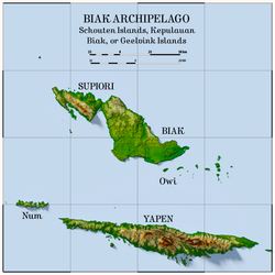
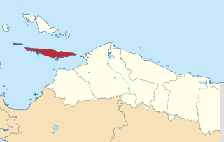
Mios Num is an island of the Yapen Islands group, in Papua Province of Western New Guinea, northeastern Indonesia.

The 1703 Genroku earthquake occurred at 02:00 local time on December 31. The epicenter was near Edo, the forerunner of present-day Tokyo, in the southern part of the Kantō region, Japan. An estimated 2,300 people were killed by the shaking and subsequent fires. The earthquake triggered a major tsunami which caused many additional casualties, giving a total death toll of at least 5,233, possibly up to 10,000. Genroku is a Japanese era spanning from 1688 through 1704.
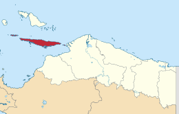
Yapen Islands Regency is a regency (kabupaten) in Papua Province of eastern Indonesia. It covers an area of 2,432.49 km2 (939.19 sq mi), and had a population of 82,951 at the 2010 Census and 112,676 at the 2020 Census; the official estimate as at mid 2022 was 116,107. It comprises an archipelago which lies in Cenderawasih Bay off the north coast of Western New Guinea.

The 1881 Chios earthquake occurred at 13:40 local time on 3 April. It caused severe damage on the island of Chios and also affected Çeşme and Alaçatı on the coast of Turkey. The earthquake had an estimated magnitude of 7.3 and there were an estimated 7,866 casualties. The devastation from the earthquake was the last of the three 'catastrophes' that affected the island of Chios in the 19th century.

The 1868 Ecuador earthquakes occurred at 19:30 UTC on August 15 and 06:30 UTC on 16 August 1868. They caused severe damage in the northeastern part of Ecuador and in southwestern Colombia. They had an estimated magnitude of 6.3 and 6.7 and together caused up to 70,000 casualties. The earthquake of 15 August occurred near El Ángel, Carchi Province, close to the border with Colombia, while that of August 16 occurred near Ibarra in Imbabura Province. Reports of these earthquakes are often confused with the effects of the earthquake of 13 August at Arica.
The 1941 Andaman Islands earthquake struck the Andaman Islands on June 26 with a magnitude of 7.7 to 8.1. Details of this event are poorly known as much of Southeast Asia was in the turmoil of World War II. The quake caused severe damage in the Andaman Islands. The tsunami it triggered was reported along the Andaman and Nicobar Islands, India and British Ceylon. There may have been damage and deaths in Bangladesh, Myanmar, and Thailand due to the tsunami.
The 1615 Arica earthquake was a major earthquake centered near Arica in the Spanish colonial Viceroyalty of Peru, within the present day Arica y Parinacota Region of northwestern Chile.
The western coast of West Sulawesi was struck by a major earthquake on 23 February 1969 at 00:36 UTC. It had a magnitude of 7.0 and a maximum felt intensity of VIII on the Modified Mercalli intensity scale. It triggered a major tsunami that caused significant damage along the coast of the Makassar Strait. At least 64 people were killed, with possibly a further 600 deaths caused by the tsunami.
The 1761 Lisbon earthquake and its subsequent tsunami occurred in the north Atlantic Ocean and south of the Iberian Peninsula. This violent shock which struck just after noon on 31 March 1761, was felt across many parts of Western Europe and in Morocco. Its direct effects were observed even far north in Scotland and Amsterdam, and to the south in the Canary Islands of Spain. The estimated surface-wave magnitude 8.5 event was the largest in the region, and the most significant earthquake in Europe since the Great Lisbon earthquake of 1755.
The 1843 Nias earthquake off the northern coast of Sumatra, Indonesia caused severe damage when it triggered a tsunami along the coastline. The earthquake with a moment magnitude (Mw ) of 7.8 lasted nine minutes, collapsing many homes in Sumatra and Nias. It was assigned a maximum modified Mercalli intensity of XI (Extreme).
On 29 November, at 14:10 UTC, a magnitude 7.7 earthquake struck off the southern coast of Taliabu Island Regency in North Maluku, Indonesia. At least 41 people were killed on the nearby islands and a tsunami was triggered. Several hundred homes, buildings and offices were damaged or destroyed.

The 1867 Central Java earthquake occurred on June 10 at between 04:20 and 04:30 local time. It struck off the southern coast of the Indonesian island with an estimated moment magnitude of 7.8 (Mw ). Widespread devastation occurred in Central Java, where as many as 700 people were killed. The intermediate-depth intraslab earthquake did not cause a tsunami.
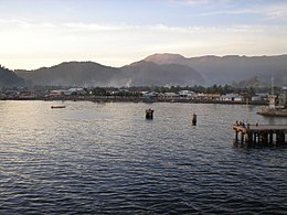
The 1979 Yapen earthquake occurred on September 12 at 05:17:51 UTC. It had an epicenter near the coast of Yapen Island in Irian Jaya, Indonesia. Measuring 7.5 on the moment magnitude scale and having a depth of 20 km (12 mi), it caused severe damage on the island. At least 115 were killed due to shaking and a moderate tsunami.