1169 Sicily earthquake

Last updated

1169 Sicily earthquake
Relief map of Italy Sicily.png
Bullseye1.png
Local date4 February 1169 (1169-02-04) [1]
Local time08:00 [2]
Magnitude7.3 Ms [3]
Epicenter 37°13′01″N14°57′00″E / 37.217°N 14.95°E / 37.217; 14.95 [2]
Areas affectedEastern Sicily
Max. intensity MMI X (Extreme)
TsunamiYes
Casualties15,000–25,000 deaths

The 1169 Sicily earthquake occurred on 4 February 1169 at 08:00 local time on the eve of the feast of St. Agatha of Sicily (in southern Italy). It had an estimated magnitude of between 6.4 and 7.3 and an estimated maximum perceived intensity of X (Extreme) on the Mercalli intensity scale. The cities of Catania, Lentini and Modica were severely damaged, and the earthquake also triggered a paleotsunami. Overall, the earthquake is estimated to have caused the deaths of at least 15,000 people.

Contents

Tectonic setting

Main faults of the Siculo-Calabrian rift zone Siculo-Calabrian Rift.png
Main faults of the Siculo-Calabrian rift zone

Sicily lies on part of the complex convergent boundary where the African Plate is subducting beneath the Eurasian Plate. This subduction zone is responsible for the formation of the stratovolcano Mount Etna. Most of the damaging earthquakes occur on the Siculo-Calabrian rift zone, a zone of extensional faulting which runs for about 370 kilometres (230 mi), forming three main segments through Calabria, along the east coast of Sicily and immediately offshore, and finally forming the southeastern margin of the Hyblean Plateau, a carbonate platform in southeastern Sicily. Faults in the Calabrian segment were responsible for the 1783 Calabrian earthquakes sequence. [4]

In the southern part of the eastern coast of Sicily, investigations have identified a series of active normal dip-slip faults, dipping to the east. Most of these lie offshore, and some control basins that contain large thicknesses of Quaternary sediments. The two largest faults, known as the western and eastern master faults, border half-grabens, with fill of up to 700 metres (2,297 ft) and 800 metres (2,625 ft) respectively. Onshore, two ages of faulting have been recognised, an earlier phase trending NW-SE and a later phase trending SSW-NNE that clearly offsets the first group, including the Avola fault and the Rosolini-Ispica fault system. [5]

Earthquake

The location of the earthquake's epicentre is quite uncertain, with different seismologists giving locations offshore and onshore; there is similar uncertainty regarding the 1693 Sicily earthquake. The damaged area is similar to that for the 1693 earthquake, suggesting that both the location and magnitude were similar. [3] Intensities of X (Extreme) have been estimated for Catania, Lentini and Modica, IX (Violent) at Syracuse and Piazza Armerina and VIII (Severe) at Santi Pietro e Paolo and Messina. The earthquake was also felt in Calabria with a maximum intensity of VI (Strong) in Reggio Calabria. [2]

The magnitude of the earthquake has been estimated from intensity information and these estimates vary from 6.4 on the Me (Energy magnitude scale) [2] to 7.3 on the surface wave magnitude scale. [3]

Tsunami

The tsunami affected most of the Ionian coast of Sicily and caused inundation from Messina in the north to the mouth of the Simeto River in the south. [6]

Tsunami deposits correlated with this earthquake have been found both onshore [7] and offshore. [8] The tsunami is also thought to be responsible for moving several large boulders from the middle of the sublittoral zone onto the coast between Augusta and Syracuse. [9]

Eruption of Etna

Some accounts of this earthquake refer to a major eruption from Etna at the time of the earthquake, blaming most of the deaths in Catania and the tsunami on the eruption. However, most later workers believe the tsunami was triggered by the earthquake and that the only effect on Etna was the collapse of part of the cone above Taormina, with no significant eruption. [10] As with the 1693 earthquake the 1169 event seems to have followed after a major period of eruptive activity. [11] Calculations have shown that a major eruption may significantly increase the stress on the normal faults to the south-east of the volcano. [12]

Damage

Catania was almost completely destroyed. Catania Cathedral collapsed, killing the Bishop John of Ajello, 44 of the Benedictine monks, and many others who were crowded into the building for the feast of St. Agatha. [13] Lentini, Modica, Aci Castello, Sortino and Syracuse were also severely damaged. [3]

In a contemporary account, Hugo Falcandus described the effects on the Arethusa spring in Syracuse, which increased its rate of flow greatly and became salty. Near Casale Saraceno the flow of another spring, known as Tais, stopped after the earthquake. Two hours later it returned with much greater force than before and had the colour of blood. [14]

Estimates of the death toll in the earthquake vary, with 15,000 being often quoted, sometimes for the overall total [15] and sometimes just for Catania. [14] A few sources give the higher estimate of 25,000. [16]

Aftermath

In the chaos that followed the earthquake, there was concern that exiles like Tancred of Lecce and Robert of Loritello would take part in a Byzantine invasion of the island. However, these disaffected exiles were soon allowed to return and there was no invasion, nor the rebellion that it might have triggered. [17]

Peter of Blois saw the earthquake as God's punishment on the Sicilians for the exile of Stephen du Perche and the appointment of Bishop John of Ajello, through bribery, to the see of Catania, replacing his brother William of Blois in the post. [18]

See also

Related Research Articles

<span class="mw-page-title-main">1908 Messina earthquake</span> Devastating 7.1 magnitude earthquake & tsunami in southern Italy

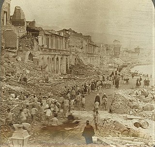
A devastating earthquake occurred on 28 December 1908 in Sicily and Calabria, southern Italy with a moment magnitude of 7.1 and a maximum Mercalli intensity of XI (Extreme). The epicentre was in the Strait of Messina which separates Sicily from the Italian mainland. The cities of Messina and Reggio Calabria were almost completely destroyed and between 75,000 and 82,000 people died, making it the most destructive earthquake ever to strike Europe.

<span class="mw-page-title-main">1693 Sicily earthquake</span> 1693 earthquake in Sicily

The 1693 Sicily earthquake struck parts of southern Italy near Sicily, Calabria, and Malta on 11 January at around 21:00 local time. This earthquake was preceded by a damaging foreshock on 9 January. The main quake had an estimated magnitude of 7.4 on the moment magnitude scale, the most powerful in Italian recorded history, and a maximum intensity of XI (Extreme) on the Mercalli intensity scale, destroying at least 70 towns and cities, seriously affecting an area of 5,600 square kilometres (2,200 sq mi) and causing the death of about 60,000 people.

The 1783 Calabrian earthquakes were a sequence of five strong earthquakes that hit the region of Calabria in southern Italy, the first two of which produced significant tsunamis. The epicenters form a clear alignment extending nearly 100 km from the Straits of Messina to about 18 km SSW of Catanzaro. The epicenter of the first earthquake occurred in the plain of Palmi. The earthquakes occurred over a period of nearly two months, all with estimated magnitudes of 5.9 or greater. Estimates of the total number of deaths lie in the range 32,000 to 50,000.

The 1968 Belice earthquake sequence took place in Sicily between 14 and 15 January. The largest shock measured 5.5 on the moment magnitude scale, with five others of magnitude 5+. The maximum perceived intensity was X (Extreme) on the Mercalli intensity scale. The earthquake sequence, centred between the towns of Gibellina, Salaparuta and Poggioreale, killed at least 231 people, possibly more than 400, with between 632 and about 1,000 injured and left 100,000 homeless. It is known in Italy as Terremoto del Belice.

The 1481 Rhodes earthquake occurred at 3:00 in the morning on 3 May. It triggered a small tsunami, which caused local flooding. There were an estimated 30,000 fatalities. It was the largest of a series of earthquakes that affected Rhodes, starting on 15 March 1481, continuing until January 1482.

<span class="mw-page-title-main">551 Beirut earthquake</span> Earthquake off the Lebanese coast

The 551 Beirut earthquake occurred on 9 July with an estimated magnitude of about 7.5 on the moment magnitude scale and a maximum felt intensity of X (Extreme) on the Mercalli intensity scale. It triggered a devastating tsunami which affected the coastal towns of Byzantine Phoenicia, causing great destruction and sinking many ships. Overall large numbers of people were reported killed, with one estimate of 30,000 by the anonymous pilgrim of Piacenza for Beirut alone.

The first of the 1894 Atalanti earthquakes occurred on 20 April 1894 at 16:52 UTC, with a magnitude of 6.4 on the moment magnitude scale and a maximum perceived intensity of X on the Mercalli intensity scale. It was followed seven days later on 27 April at 19:42 UTC by the second, with a magnitude of 6.9 and had a maximum intensity of X. These two earthquakes caused widespread damage in the Locris area, causing a total of 255 deaths. More literature on these destructive events can be seen in the references section.

The 1886 Peloponnese earthquake occurred at 23:27 local time on 27 August. It had an estimated magnitude between 6.8 and 7.3 on the moment magnitude scale and a maximum felt intensity of X (Extreme) on the Mercalli intensity scale. It caused extensive damage in Messenia, with the towns of Filiatra and Marathos both severely affected. Between 326 and 600 people were killed. It was felt over a wide area from the Khedivate of Egypt to Malta and possibly as far away as Bern and Marseille.

<span class="mw-page-title-main">1669 eruption of Mount Etna</span> Volcanic eruption in Sicily, Italy

The 1669 eruption of Mount Etna is the largest-recorded historical eruption of the volcano on the east coast of Sicily, Italy. After several weeks of increasing seismic activity that damaged the town of Nicolosi and other settlements, an eruption fissure opened on the southeastern flank of Etna during the night of 10–11 March. Several more fissures became active during 11 March, erupting pyroclastics and tephra that fell over Sicily and accumulated to form the Monti Rossi scoria cone.

In early 1981 the eastern Gulf of Corinth, Greece was struck by three earthquakes with a magnitude greater than 6 Ms over a period of 11 days. The earthquake sequence caused widespread damage in the Corinth–Athens area, destroying nearly 8,000 houses and causing 20–22 deaths.

The 1990 Carlentini earthquake occurred off the Sicilian coast, 20 km east northeast from the town of Augusta, Sicily on 13 December at 01:24 local time. The moderately-sized earthquake measuring 5.6 on the moment magnitude scale (Mw ) resulted in the deaths of 19 people and caused at least 200 injuries. It also inflicted significant damage in the region, leaving 2,500 homeless.

The 1790 Oran earthquake occurred on 10 October, striking near the coastal city of Oran in Algeria. The earthquake had an evaluated maximum seismic intensity of VIII–X on the European macroseismic scale (EMS-98). An estimated 3,000 people died during the earthquake and accompanying tsunami. The magnitude of this earthquake has been disputed among members of the paleoseismology field, with estimates ranging from 7.5 to even as small as 5.5.

The 1716 Algiers earthquake was part of a seismic sequence which began in February and ended in May 1716. The largest and most destructive shock occurred on February 3 with an estimated moment magnitude of 7.0. The earthquakes with an epicenter thought to be in the Algiers region had a maximum European macroseismic scale (EMS-98) intensity of IX (Destructive), killing approximately 20,000 people. The earthquake was felt in Catania and Syracuse on the Italian island Sicily.

On December 5, 1456, the largest earthquake to occur on the Italian Peninsula struck the Kingdom of Naples. The earthquake had an estimated moment magnitude of Mw  7.19–7.4, and was centred near the town of Pontelandolfo in the present-day Province of Benevento, southern Italy. Earning a level of XI (Extreme) on the Modified Mercalli intensity scale, the earthquake caused widespread destruction in central and southern Italy. Estimates of the death toll range greatly with as many as 70,000 deaths reported. It was followed by two strong Mw  7.0 and 6.0 earthquakes to the north on December 30. The earthquake sequence is considered the largest in Italian history, and one of the most studied.

A series of four mainshocks struck Calabria on March 27–28 and June 9, 1638. The first three earthquakes had moment magnitudes estimated to be Mw 6.6–7.1. On June 9, another mainshock estimated at Mw  6.7 struck the same region, causing further damage and casualties. The four earthquakes resulted in as many as 30,000 fatalities.

The 1743 Salento earthquake affected the Apulian region of southwestern Italy on 20 February at 23:30 IST. The ~7.1 Mw  earthquake had an epicenter in the Adriatic and Ionian seas, off the coast of modern-day Lecce and Brindisi provinces in Salento. It had a maximum Modified Mercalli intensity of IX (Violent), causing heavy damage in Nardò. Damage was also reported across the sea, in the Balkans. The earthquake also generated a tsunami of up to 11 meters in run-up. Between 180 and 300 people were killed in the disaster.

<span class="mw-page-title-main">1867 Keelung earthquake</span> Earthquake and tsunami affecting the northern coast of Taiwan

The 1867 Keelung earthquake occurred off the northern coast of Taiwan on the morning of December 18 with a magnitude of 7.0. It produced strong shaking that seriously damaged the cities of Keelung and Taipei. A tsunami, thought to be the only confirmed destructive of its kind in Taiwan, drowned hundreds and had a run-up exceeding 15 m (49 ft). The total death toll was estimated to be 580 while more than 100 were injured. It was followed by aftershocks that were felt on average ten times a day.

<span class="mw-page-title-main">1833 Shōnai earthquake</span> Earthquake in Japan

The Shōnai offshore earthquake occurred at around 14:00 on December 7, 1833. It struck with an epicenter in the Sea of Japan, off the coast of Yamagata Prefecture, Japan. A tsunami was triggered by the estimated MJMA  7.5–7.7 earthquake. One hundred and fifty people were killed and there was severe damage in the prefecture.

<span class="mw-page-title-main">Siculo-Calabrian rift</span> Geological feature in Italy

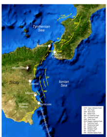
The Siculo-Calabrian rift is a zone of active extensional tectonics running about 200 km from northern Calabria to near Syracuse in Sicily. It is formed of a series of overlapping normal faults that control graben and half-graben on their downthrown sides. These faults have regularly ruptured historically, causing destructive earthquakes, often in sequences, such as the 1783 Calabrian earthquakes.

References

  1. Barbano, Maria Serafina; De Martini, P.M.; Pantosti, D.; Smedile, A.; Del Carlo, P.; Gerardi, F.; Guarnieri, P.; Pirrotta, C. (2010). "In search of tsunami deposits along the eastern coast of Sicily (Italy): state of the art". In Guarnieri, Pierpaolo (ed.). Recent progress on earthquake geology (PDF). New York: Nova Science Publishers. ISBN   9781608761470. OCLC   429026456.
  2. 1 2 3 4 Guidoboni, E.; Ferrari G.; Mariotti D.; Comastri A.; Tarabusi G. & Valensise G. "Catalogue of Strong Earthquakes in Italy (461 BC – 1997) and Mediterranean Area (760 B.C. – 1500)". INGV-SGA. Retrieved 24 June 2012.
  3. 1 2 3 4 Azzaro, R.; Barbano M.S. (2000). "Analysis of the seismicity of Southeastern Sicily: a proposed tectonic interpretation". Annali di Geofisica. 43 (1): 171–188. Viewed 25 June 2012.
  4. Catalano, S.; De Guidi G.; Monaco C.; Tortorici G. & Tortorici L. (2008). "Active faulting and seismicity along the Siculo–Calabrian Rift Zone (Southern Italy)". Tectonophysics. 453 (1–4). Elsevier: 177–192. Bibcode:2008Tectp.453..177C. doi:10.1016/j.tecto.2007.05.008.
  5. Bianca, M.; Monaco C.; Tortorici L. & Cernobori L. (1999). "Quaternary normal faulting in southeastern Sicily (Italy): a seismic source for the 1693 large earthquake". Geophysical Journal International . 139 (2). London: Royal Astronomical Society: 370–394. Bibcode:1999GeoJI.139..370B. doi: 10.1046/j.1365-246X.1999.00942.x .
  6. De Martini, P.M.; Barbano M.S.; Smedile A.; Gerardi F.; Pantosti D.; Del Carlo P. & Pirrotta C. (2010). "A unique 4000 yrs long geological record of multiple tsunami inundations in the Augusta Bay (eastern Sicily, Italy)" (PDF). Marine Geology. 276 (1–4). Elsevier: 42–57. Bibcode:2010MGeol.276...42D. doi:10.1016/j.margeo.2010.07.005 . Retrieved 24 June 2012.
  7. Scicchitano, G.; Costa B.; Di Stefano A.; Longhitano S. & Monaco C. (2008). "Tsunami deposits in the Siracusa coastal area (south-eastern Sicily)" (PDF). Rend. Online SGI Note Brevi. 1. Società Geologica Italiana: 159–162. Archived from the original (PDF) on 25 February 2012. Retrieved 24 June 2012.
  8. Smedile, A.; De Martini P.M.; Pantosti D.; Bellucci L.; Del Carlo P.; Gasperini L.; Pirrotta C.; Polonia A. & Boschi E. (2011). "Possible tsunami signatures from an integrated study in the Augusta Bay offshore (Eastern Sicily—Italy)". Marine Geology. 281 (1–4). Elsevier: 1–13. Bibcode:2011MGeol.281....1S. doi:10.1016/j.margeo.2011.01.002.
  9. Scicchitano, G.; Monaco C. & Tortorici L. (2007). "Large boulder deposits by tsunami waves along the Ionian coast of south-eastern Sicily (Italy)". Marine Geology. 238 (1–4). Elsevier: 75–91. Bibcode:2007MGeol.238...75S. doi:10.1016/j.margeo.2006.12.005.
  10. Tinti, S. (1993). Tsunamis in the World. Advances in Natural and Technological Hazards Research. Vol. 1. Springer. p. 57. ISBN   978-0-7923-2316-7.
  11. Hirn, A.; Nicolich R.; Gallart J.; Laigle M.; Cernobori L. & ETNASEIS Scientific Group (1997). "Roots of Etna volcano in faults of great earthquakes". Earth and Planetary Science Letters. 148 (1–2). Elsevier: 171–191. Bibcode:1997E&PSL.148..171H. doi:10.1016/S0012-821X(97)00023-X.
  12. Feuillet, N.; Cocco M.; Musumeci C. & Nostro C. (2006). "Stress interaction between seismic and volcanic activity at Mt Etna" (PDF). Geophysical Journal International. 164 (3). London: Royal Astronomical Society: 697–718. Bibcode:2006GeoJI.164..697F. doi: 10.1111/j.1365-246X.2005.02824.x .
  13. White, L.T. (1938). Latin Monasticism in Norman Sicily. The Mediaeval academy of America. Vol. 31. Mediaeval Academy of America. p. 115.
  14. 1 2 Falcando, Ugo (1998). Loud G.A.; Wiedmann T.E.J. (eds.). The History of the Tyrants of Sicily by "Hugo Falcandus," 1154–69. Manchester University Press. pp. 216–217. ISBN   978-0-7190-5435-8.
  15. Solov'ev, S.L. (2000). Tsunamis in the Mediterranean Sea, 2000 B.C.-2000 A.D. Advances in Natural and Technological Hazards Research. Vol. 13. Springer. p. 36. ISBN   978-0-7923-6548-8.
  16. Barbano, M.S.; De Martini P.M.; Pantosti D.; Smedile A.; Del Carlo P.; Gerardi F.; Guarnieri P. & Pirrotta C. (2011). "In search of Tsunami deposits along the eastern coast of Sicily (Italy): state of the art" (PDF). In Guarnieri P. (ed.). Recent Progress on Earthquake Geology. Nova. pp. 109–146. ISBN   978-1-60876-147-0 . Retrieved 25 June 2012.
  17. Metcalfe, A. (2009). The Muslims of Medieval Italy. Edinburgh University Press. p. 205. ISBN   978-0-7486-2008-1.
  18. Peter of Blois. "Some Letters of Peter of Blois concerning Sicily" (PDF). Translated by Loud G.A. pp. 4–6. Archived from the original (PDF) on 10 December 2013. Retrieved 25 June 2012.