A volcano observatory is an institution that conducts research and monitoring of a volcano.
An earthquake occurred northeast of the city of Adana in the Armenian Kingdom of Cilicia on 14 May 1269 at "the first hour of the night". Most sources give a death toll of 8,000 in the Armenian Kingdom of Cilicia in southern Asia Minor, but a figure of 60,000 dead was reported by Robert Mallet in 1853 and repeated in many later catalogues.
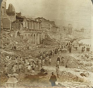
An earthquake occurred on 28 December 1908 in Sicily and Calabria, southern Italy with a moment magnitude of 7.1 and a maximum Mercalli intensity of XI (Extreme). The epicentre was in the Strait of Messina which separates Sicily from the Italian mainland. The cities of Messina and Reggio Calabria were almost completely destroyed and between 75,000 and 82,000 people died, making it the most destructive earthquake ever to strike Europe.
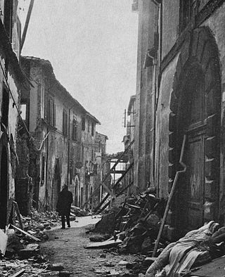
The 1980 Irpinia earthquake took place in Italy on 23 November 1980, with a moment magnitude of 6.9 and a maximum Mercalli intensity of X (Extreme). It left at least 2,483 people dead, at least 7,700 injured, and 250,000 homeless.
On 5 February AD 62, an earthquake of an estimated magnitude of between 5 and 6 and a maximum intensity of IX or X on the Mercalli scale struck the towns of Pompeii and Herculaneum, severely damaging them. The earthquake may have been a precursor to the eruption of Mount Vesuvius in AD 79, which destroyed the same two towns. The contemporary philosopher and dramatist Seneca the Younger wrote an account of the earthquake in the sixth book of his Naturales quaestiones, entitled De Terrae Motu.
The National Institute of Geophysics and Volcanology is a research institute for geophysics and volcanology in Italy.
After a year of foreshocks, an earthquake occurred on 12 August 1157 near the city of Hama, in west-central Syria, where the most casualties were sustained. In eastern Syria, near the Euphrates, the quake destroyed the predecessor of the citadel al-Rahba, subsequently rebuilt on the same strategic site. The earthquake also affected Christian monasteries and churches in the vicinity of Jerusalem.
Two major earthquakes occurred in the Near East on 18 March and 29 May, AD 1068. The two earthquakes are often amalgamated by contemporary sources. The first earthquake had its epicentre somewhere in the northwestern part of the Arabian Peninsula around Tabuk, while the second was most damaging in the city of Ramla in Palestine, some 500 km to the northwest.
The Gibilmanna Observatory is a research station used for a diverse range of studies set up and run by the Istituto Nazionale di Geofisica e Vulcanologia (INGV) and it is located on Cozzo Timpa Rossa at 1005 m.a.s.l. near Cefalù, a town in the district of Palermo, Italy.
The 1139 Ganja earthquake was one of the worst seismic events in history. It affected the Seljuk Empire and Kingdom of Georgia; modern-day Azerbaijan and Georgia. The earthquake had an estimated magnitude of 7.7 , 7.5 and 7.0–7.3 . A controversial death toll of 230,000–300,000 came as a consequence of this event.
The 1971 Tuscania earthquake occurred on 6 February in Italy. It had an epicenter located halfway between Tuscania and Arlena di Castro, about 20 km west of Viterbo. It had a body wave magnitude of 4.6.
On December 5, 1456, the largest earthquake to occur on the Italian Peninsula struck the Kingdom of Naples. The earthquake had an estimated moment magnitude of Mw 7.19–7.4, and was centred near the town of Pontelandolfo in the present-day Province of Benevento, southern Italy. Earning a level of XI (Extreme) on the Modified Mercalli intensity scale, the earthquake caused widespread destruction in central and southern Italy. Estimates of the death toll range greatly with as many as 70,000 deaths reported. It was followed by two strong Mw 7.0 and 6.0 earthquakes to the north on December 30. The earthquake sequence is considered the largest in Italian history, and one of the most studied.
A series of four mainshocks struck Calabria on March 27–28 and June 9, 1638. The first three earthquakes had moment magnitudes estimated to be 6.6–7.1. On June 9, another mainshock estimated at Mw 6.7 struck the same region, causing further damage and casualties. The four earthquakes resulted in as many as 30,000 fatalities.
The second shock in the 1962 Irpinia earthquake sequence was the largest and most destructive in a series of earthquakes in the southern Apennines. It occurred on 21 August at 18:19 CET, measuring 6.15 and assigned a maximum intensity of IX (Violent). It was preceded by an Mw 5.68 foreshock, and followed by a 5.34 aftershock. The earthquakes resulted in nearly 20 fatalities and significant property losses.
The 1706 Abruzzo earthquake, also known as the Maiella earthquake, occurred on November 3 at 13:00 CEST. The earthquake with a possible epicenter in the Central Apennine Mountains (Maiella), Abruzzo had an estimated moment magnitude of 6.6–6.84 Mw . It was assigned a maximum Mercalli intensity of XI (Extreme), causing tremendous destruction in Valle Peligna. At least 2,400 people were killed.
The 1743 Salento earthquake affected the Apulian region of southwestern Italy on 20 February at 23:30 IST. The ~7.1 Mw earthquake had an epicenter in the Adriatic and Ionian seas, off the coast of modern-day Lecce and Brindisi provinces in Salento. It had a maximum Modified Mercalli intensity of IX (Violent), causing heavy damage in Nardò. Damage was also reported across the sea, in the Balkans. The earthquake also generated a tsunami of up to 11 meters in run-up. Between 180 and 300 people were killed in the disaster.
The 1875 Dinar earthquake occurred in Afyonkarahisar Province in present-day Turkey. More than 1,300 people died and 1,000 homes were destroyed when the Mw 6.77 earthquake struck. The communities of Çivril and Yaka were destroyed while Işıklı and Dinar were badly damaged. Ground fissures and hot springs appeared near Civril although these reports may have been exaggerated. There was minor damage in Uşak and Afyon.
Antonio Costa is a geophysicist and academic. He is a Senior Researcher at the National Institute of Geophysics and Volcanology (INGV) Branch of Bologna, and an adjunct professor at the University of Bologna, in Bologna, Italy.
