Related Research Articles

Mount Tambora, or Tomboro, is an active stratovolcano in West Nusa Tenggara, Indonesia. Located on Sumbawa in the Lesser Sunda Islands, it was formed by the active subduction zones beneath it. Before 1815, its elevation reached more than 4,300 metres high, making it one of the tallest peaks in the Indonesian archipelago.

The volcanic winter of 536 was the most severe and protracted episode of climatic cooling in the Northern Hemisphere in the last 2,000 years. The volcanic winter was caused by at least three simultaneous eruptions of uncertain origin, with several possible locations proposed in various continents. Most contemporary accounts of the volcanic winter are from authors in Constantinople, the capital of the Eastern Roman Empire, although the impact of the cooler temperatures extended beyond Europe. Modern scholarship has determined that in early AD 536, an eruption ejected massive amounts of sulfate aerosols into the atmosphere, which reduced the solar radiation reaching the Earth's surface and cooled the atmosphere for several years. In March 536, Constantinople began experiencing darkened skies and lower temperatures.

A volcanic winter is a reduction in global temperatures caused by droplets of sulfuric acid obscuring the Sun and raising Earth's albedo (increasing the reflection of solar radiation) after a large, sulfur-rich, particularly explosive volcanic eruption. Climate effects are primarily dependent upon the amount of injection of SO2 and H2S into the stratosphere where they react with OH and H2O to form H2SO4 on a timescale of a week, and the resulting H2SO4 aerosols produce the dominant radiative effect. Volcanic stratospheric aerosols cool the surface by reflecting solar radiation and warm the stratosphere by absorbing terrestrial radiation for several years. Moreover, the cooling trend can be further extended by atmosphere–ice–ocean feedback mechanisms. These feedbacks can continue to maintain the cool climate long after the volcanic aerosols have dissipated.

Eldgjá is a volcano and a canyon in Iceland. Eldgjá is part of the Katla volcano; it is a segment of a 40 kilometres (25 mi) long chain of volcanic craters and fissure vents that extends northeast away from Katla volcano almost to the Vatnajökull ice cap. This fissure experienced a major eruption around 939 CE, which was the largest effusive eruption in recent history. It covered about 780 square kilometres (300 sq mi) of land with 18.6 cubic kilometres (4.5 cu mi) of lava from two major lava flows.

Mount Takahe is a 3,460-metre-high (11,350 ft) snow-covered shield volcano in Marie Byrd Land, Antarctica, 200 kilometres (120 mi) from the Amundsen Sea. It is a c. 30-kilometre-wide (19 mi) mountain with parasitic vents and a caldera up to 8 kilometres (5 mi) wide. Most of the volcano is formed by trachytic lava flows, but hyaloclastite is also found. Snow, ice, and glaciers cover most of Mount Takahe. With a volume of 780 km3 (200 cu mi), it is a massive volcano; the parts of the edifice that are buried underneath the West Antarctic Ice Sheet are probably even larger. It is part of the West Antarctic Rift System along with eighteen other known volcanoes.
Haraldur Sigurðsson or Haraldur Sigurdsson is an Icelandic volcanologist and geochemist.

The Minoan eruption was a catastrophic volcanic eruption that devastated the Aegean island of Thera circa 1600 BCE. It destroyed the Minoan settlement at Akrotiri, as well as communities and agricultural areas on nearby islands and the coast of Crete with subsequent earthquakes and paleotsunamis. With a Volcanic Explosivity Index (VEI) of between 6 and 7, it resulted in the ejection of approximately 28–41 km3 (6.7–9.8 cu mi) of dense-rock equivalent (DRE), the eruption was one of the largest volcanic events in human history. Since tephra from the Minoan eruption serves as a marker horizon in nearly all archaeological sites in the Eastern Mediterranean, its precise date is of high importance and has been fiercely debated among archaeologists and volcanologists for decades, without coming to a definite conclusion.
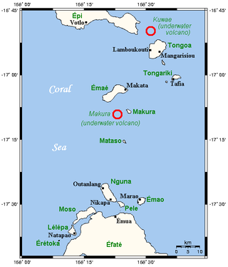
Kuwae was a landmass that existed in the vicinity of Tongoa and was destroyed by volcanic eruption in fifteenth century, probably through caldera subsidence. The exact location of the caldera is debated. A submarine caldera, now known as Kuwae caldera that is located between the Epi and Tongoa islands is a potential candidate. Kuwae Caldera cuts through the flank of the Tavani Ruru volcano on Epi and the northwestern end of Tongoa. Another potential candidate is a proposed caldera between Tongoa and Tongariki.

This timeline of volcanism on Earth includes a list of major volcanic eruptions of approximately at least magnitude 6 on the Volcanic explosivity index (VEI) or equivalent sulfur dioxide emission during the Quaternary period. Other volcanic eruptions are also listed.
Mount Tambora is a volcano on the island of Sumbawa in present-day Indonesia, then part of the Dutch East Indies, and its 1815 eruption was the most powerful volcanic eruption in recorded human history. This volcanic explosivity index (VEI) 7 eruption ejected 37–45 km3 of dense-rock equivalent (DRE) material into the atmosphere, and was the most recent confirmed VEI-7 eruption.

The 1808 mystery eruption is one or potentially multiple unidentified volcanic eruptions that resulted in a significant rise in stratospheric sulfur aerosols, leading to a period of global cooling analogous to the Year Without a Summer in 1816.
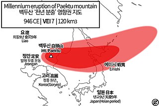
The 946 eruption of Paektu Mountain in Korea and China, also known as the Millennium Eruption or Tianchi eruption, was one of the most powerful volcanic eruptions in recorded history and is classified as a VEI-6 event. The eruption resulted in a brief period of significant climate change in Manchuria. The eruption occurred in late 946 CE.
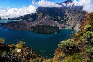
In 1257, a catastrophic eruption occurred at Samalas, a volcano on the Indonesian island of Lombok. The event had a probable Volcanic Explosivity Index of 7, making it one of the largest volcanic eruptions during the Holocene epoch. It left behind a large caldera that contains Lake Segara Anak. Later volcanic activity created more volcanic centres in the caldera, including the Barujari cone, which remains active.

Kurile Lake is a caldera and crater lake in Kamchatka, Russia. It is also known as Kurilskoye Lake or Kuril Lake. It is part of the Eastern Volcanic Zone of Kamchatka which, together with the Sredinny Range, forms one of the volcanic belts of Kamchatka. These volcanoes form from the subduction of the Pacific Plate beneath the Okhotsk Plate and the Asian Plate.
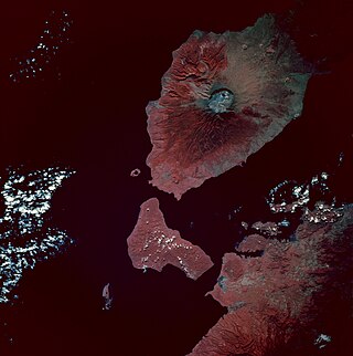
Laika is a small uninhabited island in the Pacific Ocean, a part of the Shepherd Islands archipelago in the Shefa Province of Vanuatu.

Tefala is a small uninhabited island in the Pacific Ocean, belonging to the Shefa Province of Vanuatu.

The Tierra Blanca Joven eruption of Lake Ilopango was the largest volcanic eruption in El Salvador during historic times, and one of the largest volcanic events on Earth in the past 7,000 years, registering at 6 on the Volcanic explosivity index (VEI), and dating back to the mid 5th century A.D. The eruption produced between 37–82 km3 (8.9–19.7 cu mi) of ejecta. The date of the eruption has been constrained within 429–433 CE by identifying its signature volcanic ash in precision-dated ice cores sampled from Greenland, thus eliminating it as the cause of extreme weather events of 535–536.
The 1452/1453 mystery eruption is an unidentified volcanic event that triggered the first large sulfate spike in the 1450s, succeeded by another spike in 1458 caused by another mysterious eruption. The eruption caused a severe volcanic winter leading to one of strongest cooling events in the Northern Hemisphere. This date also coincides with a substantial intensification of the Little Ice Age.
References
- 1 2 3 Plummer, Christopher T.; Curran, M. A. J.; van Ommen, Tas D.; Rasmussen, S.O.; Moy, A. D.; Vance, Tessa R.; Clausen, H. B.; Vinther, Bo M.; Mayewski, P. A. (2012-05-01). "An independently dated 2000-yr volcanic record from Law Dome, East Antarctica, including a new perspective on the dating of the c. 1450s eruption of Kuwae, Vanuatu". Climate of the Past Discussions. 8: 1567–1590. doi: 10.5194/cpd-8-1567-2012 .
- 1 2 3 4 5 Cole-Dai, Jihong; Ferris, David G.; Lanciki, Alyson L.; Savarino, Joël; Thiemens, Mark H.; McConnell, Joseph R. (2013-07-17). "Two likely stratospheric volcanic eruptions in the 1450s C.E. found in a bipolar, subannually dated 800 year ice core record". Journal of Geophysical Research: Atmospheres. 118 (14): 7459–7466. Bibcode:2013JGRD..118.7459C. doi: 10.1002/jgrd.50587 . S2CID 129790360.
- 1 2 3 4 Hartman, Laura H.; Kurbatov, Andrei V.; Winski, Dominic A.; Cruz-Uribe, Alicia M.; Davies, Siwan M.; Dunbar, Nelia W.; Iverson, Nels A.; Aydin, Murat; Fegyveresi, John M.; Ferris, David G.; Fudge, T. J.; Osterberg, Erich C.; Hargreaves, Geoffrey M.; Yates, Martin G. (8 October 2019). "Volcanic glass properties from 1459 C.E. volcanic event in South Pole ice core dismiss Kuwae caldera as a potential source". Scientific Reports. 9 (1): 14437. Bibcode:2019NatSR...914437H. doi:10.1038/s41598-019-50939-x. ISSN 2045-2322. PMC 6783439 . PMID 31595040.
- 1 2 3 Németh, Károly; Cronin, Shane J.; White, James D. L. (2007-11-27). "Kuwae Caldera and Climate Confusion". The Open Geology Journal. 1 (1): 7–11. Bibcode:2007OGJ.....1....7N. doi: 10.2174/1874262900701010007 .
- 1 2 3 Bauch, Martin (2017), "The Day the Sun Turned Blue: A Volcanic Eruption in the Early 1460s and Its Possible Climatic Impact—A Natural Disaster Perceived Globally in the Late Middle Ages?", Historical Disaster Experiences, Transcultural Research – Heidelberg Studies on Asia and Europe in a Global Context, Cham: Springer International Publishing, pp. 107–138, doi:10.1007/978-3-319-49163-9_6, ISBN 978-3-319-49162-2
- ↑ Delmas, Robert J.; Kirchner, Severine; Palais, Julie M.; Petit, Jean-Robert (1992). "1000 years of explosive volcanism recorded at the South Pole". Tellus B. 44 (4): 335–350. doi:10.1034/j.1600-0889.1992.00011.x. ISSN 0280-6509.
- 1 2 3 Gao, Chaochao; Robock, Alan; Self, Stephen; Witter, Jeffrey B.; Steffenson, J. P.; Clausen, Henrik Brink; Siggaard-Andersen, Marie-Louise; Johnsen, Sigfus; Mayewski, Paul A.; Ammann, Caspar (2006). "The 1452 or 1453 A.D. Kuwae eruption signal derived from multiple ice core records: Greatest volcanic sulfate event of the past 700 years". Journal of Geophysical Research. 111 (D12): D12107. Bibcode:2006JGRD..11112107G. doi: 10.1029/2005JD006710 . ISSN 0148-0227.
- 1 2 3 4 Sigl, Michael; McConnell, Joseph R.; Layman, Lawrence; Maselli, Olivia; McGwire, Ken; Pasteris, Daniel; Dahl-Jensen, Dorthe; Steffensen, Jørgen Peder; Vinther, Bo; Edwards, Ross; Mulvaney, Robert; Kipfstuhl, Sepp (2013-02-16). "A new bipolar ice core record of volcanism from WAIS Divide and NEEM and implications for climate forcing of the last 2000 years: A 2000YR BIPOLAR VOLCANO RECORD". Journal of Geophysical Research: Atmospheres. 118 (3): 1151–1169. doi:10.1029/2012JD018603. S2CID 130773456.
- ↑ Sigl, Michael; Toohey, Matthew; McConnell, Joseph R.; Cole-Dai, Jihong; Severi, Mirko (2022-07-12). "Volcanic stratospheric sulfur injections and aerosol optical depth during the Holocene (past 11 500 years) from a bipolar ice-core array". Earth System Science Data. 14 (7): 3167–3196. doi: 10.5194/essd-14-3167-2022 . ISSN 1866-3516.
- ↑ Sigl, Michael; Toohey, Matthew; McConnell, Joseph R.; Cole-Dai, Jihong; Severi, Mirko (2021-03-02). "HolVol: Reconstructed volcanic stratospheric sulfur injections and aerosol optical depth for the Holocene (9500 BCE to 1900 CE)". Pangaea. doi:10.1594/PANGAEA.928646.
{{cite journal}}: Cite journal requires|journal=(help) - ↑ Hartman, Laura H.; Kurbatov, Andrei V.; Winski, Dominic A.; Cruz-Uribe, Alicia M.; Davies, Siwan M.; Dunbar, Nelia W.; Iverson, Nels A.; Aydin, Murat; Fegyveresi, John M.; Ferris, David G.; Fudge, T. J.; Osterberg, Erich C.; Hargreaves, Geoffrey M.; Yates, Martin G. (2019-10-08). "Volcanic glass properties from 1459 C.E. volcanic event in South Pole ice core dismiss Kuwae caldera as a potential source". Scientific Reports. 9 (1): 14437. doi:10.1038/s41598-019-50939-x. ISSN 2045-2322. PMC 6783439 . PMID 31595040.
- ↑ Esper, Jan; Büntgen, Ulf; Hartl-Meier, Claudia; Oppenheimer, Clive; Schneider, Lea (2017-05-06). "Northern Hemisphere temperature anomalies during the 1450s period of ambiguous volcanic forcing". Bulletin of Volcanology. 79 (6): 41. doi:10.1007/s00445-017-1125-9. ISSN 1432-0819. S2CID 133844199.
- ↑ Garanger, José (1972). Archéologie des Nouvelles-Hébrides: Contribution à la connaissance des îles du Centre (in French). Société des Océanistes. doi:10.4000/books.sdo.859. ISBN 978-2-85430-054-3.
- 1 2 Monzier, Michel; Robin, Claude; Eissen, Jean-Philippe (1994-01-01). "Kuwae (≈ 1425 A.D.): the forgotten caldera". Journal of Volcanology and Geothermal Research. 59 (3): 207–218. doi:10.1016/0377-0273(94)90091-4. ISSN 0377-0273.
- ↑ Witter, J. B.; Self, S. (2007-01-01). "The Kuwae (Vanuatu) eruption of AD 1452: potential magnitude and volatile release". Bulletin of Volcanology. 69 (3): 301–318. Bibcode:2007BVol...69..301W. doi:10.1007/s00445-006-0075-4. ISSN 1432-0819. S2CID 129403009.
- ↑ "Secrets of Kuwae begin to be revealed - CHL - ANU". chl.anu.edu.au. Retrieved 2023-01-18.[ permanent dead link ]
- ↑ Shane J Cronin; Katharine V Cashman (2016-06-03). "Volcanic Oral Traditions in Hazard Assessment and Mitigation". In Grattan, John; Torrence, Robin (eds.). Living Under the Shadow. pp. 185–212. doi:10.4324/9781315425177. ISBN 9781315425160.
- ↑ Stern, Charles R. (2008-02-01). "Holocene tephrochronology record of large explosive eruptions in the southernmost Patagonian Andes". Bulletin of Volcanology. 70 (4): 435–454. doi:10.1007/s00445-007-0148-z. ISSN 1432-0819. S2CID 140710192.
- ↑ Abbott, Peter M.; Plunkett, Gill; Corona, Christophe; Chellman, Nathan J.; McConnell, Joseph R.; Pilcher, John R.; Stoffel, Markus; Sigl, Michael (2021-03-04). "Cryptotephra from the Icelandic Veiðivötn 1477 CE eruption in a Greenland ice core: confirming the dating of volcanic events in the 1450s CE and assessing the eruption's climatic impact". Climate of the Past. 17 (2): 565–585. doi: 10.5194/cp-17-565-2021 . ISSN 1814-9324. S2CID 233267071.