
The 1999 Athens earthquake occurred on September 7 at near Mount Parnitha in Greece with a moment magnitude of 6.0 and a maximum Mercalli intensity of IX (Violent). The proximity to the Athens metropolitan area resulted in widespread structural damage, mainly to the nearby suburban towns of Ano Liosia, Acharnes, Fyli, Thrakomakedones, Kifissia, Metamorfosi, Kamatero and Nea Filadelfeia. More than 100 buildings across those areas collapsed trapping scores of victims under their rubble while dozens more were severely damaged. With damage estimated at $3–4.2 billion, 143 people were killed, and up to 1,600 were treated for injuries in Greece's deadliest natural disaster in almost half a century.
The 1202 Syria earthquake struck at about dawn on 20 May 1202 with an epicenter in southwestern Syria. The earthquake is estimated to have killed around 30,000 people. It was felt over an extensive area, from Sicily to Mesopotamia and Anatolia to upper Egypt, mostly affecting the Ayyubid Sultanate and the Kingdom of Jerusalem. The cities of Tyre, Acre and Nablus were heavily damaged. A magnitude of 7.6 has been estimated with damage up to XI on the Mercalli intensity scale.
The Rhodes earthquake of 226 BC, which affected the island of Rhodes, Greece, is famous for having toppled the large statue known as the Colossus of Rhodes. Following the earthquake, the statue lay in place for nearly eight centuries before being sold off by invaders. While 226 BC is most often cited as the date of the quake, sources variously cite 226 or 227 BC as dates when it occurred.
The 1868 Hawaiʻi earthquake was the largest recorded in the history of Hawaiʻi island, with an estimated magnitude of 7.9 and a maximum Mercalli intensity of X (Extreme). The earthquake occurred at 4 p.m. local time on April 2, 1868 and caused a landslide and tsunami that led to 77 deaths. The aftershock sequence for this event has continued up to the present day.
The 1992 Cape Mendocino earthquakes occurred along the Lost Coast of Northern California on April 25 and 26. The three largest events were the M7.2 thrust mainshock that struck near the unincorporated community of Petrolia midday on April 25 and two primary strike-slip aftershocks measuring 6.5 and 6.6 that followed early the next morning. The sequence encompassed both interplate and intraplate activity that was associated with the Mendocino Triple Junction, a complex system of three major faults that converge near Cape Mendocino. The total number of aftershocks that followed the events exceeded 2,000.
The 1303 Crete earthquake occurred at about dawn on 8 August. It had an estimated magnitude of about 8, a maximum intensity of IX (Violent) on the Mercalli intensity scale, and triggered a major tsunami that caused severe damage and loss of life on Crete and at Alexandria. It badly damaged the Lighthouse of Alexandria.
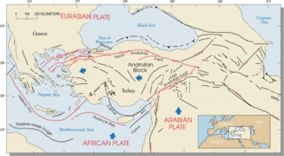
The Hellenic arc or Aegean arc is an arcuate mountain chain of the southern Aegean Sea located on the southern margin of the Aegean Sea Plate. Geologically it results from the subduction of the African Plate under it along the Hellenic subduction zone. The Hellenic Trench trends parallel to its southern side. The Aegean Sea Plate, a microplate, is often considered part of the Eurasian Plate from which it is in the process of diverging. The arc itself is mainly marine, the mountaintops appearing as islands in the Ionian Sea, Crete and its environs, or in the Dodecanese group. It encroaches on mainland terrain in the Peloponnesus, on Crete, on Rhodes, and on the southern coast of Anatolia, thus being encompassed by both Greece and Turkey.
The 1810 Crete earthquake occurred at 22:15 on 16 February. It caused great destruction in Heraklion and some damage from Malta to northern Egypt, and was felt from central Italy to Syria. 300 fatalities were reported from Candia (Heraklion).
The 1956 Amorgos earthquake occurred at 03:11 UTC on July 9. It had a magnitude of 7.7 on the moment magnitude scale and a maximum perceived intensity of IX on the Mercalli intensity scale. The epicentre was to the south of the island of Amorgos, the easternmost island of the Cyclades in the Aegean Sea. There was significant damage on Amorgos and the neighbouring island of Santorini. It was the largest earthquake in Greece in the 20th century. It was followed 13 minutes later by a magnitude 7.2 earthquake near Santorini. It triggered a major tsunami with a maximum run-up of 30 m. The combined effects of the earthquake shaking and the tsunami caused the deaths of 53 people with a further 100 injured.
The 1886 Peloponnese earthquake occurred at 23:27 local time on 27 August. It had an estimated magnitude between 6.8 and 7.3 on the moment magnitude scale and a maximum felt intensity of X (Extreme) on the Mercalli intensity scale. It caused extensive damage in Messenia, with the towns of Filiatra and Marathos both severely affected. Between 326 and 600 people were killed. It was felt over a wide area from the Khedivate of Egypt to Malta and possibly as far away as Bern and Marseille.
The 1953 Paphos earthquake struck British Cyprus on the morning of 10 September, at 06:05 EET. It had a magnitude of Ms 6.5 on the surface-wave magnitude scale, and had a maximum intensity of X (Extreme) on the Modified Mercalli intensity scale. The epicenter of this earthquake was situated off the island's west coast, near the city of Paphos. At least 40 people died and 100 were injured. It was also felt in Rhodes, Turkey, Egypt, Lebanon and Kastellorizo.
The 1856 Heraklion earthquake, also known as the Crete earthquake or Rhodes earthquake, occurred on the morning of October 12 at 02:45 am local time. This extremely catastrophic earthquake had an estimated magnitude of 7.7 to 8.3 at a depth of approximately 61 to 100 km. The earthquake was felt over a very wide area extending from Sicily, Italy to the Levant and North Africa. On the Greek island of Crete, the effects of the earthquake were cataclysmic, over 500 bodies were recovered in the city of Heraklion. Shockwaves from the earthquake were felt intensely, covering all of the Ottoman Empire; present-day Turkey, Cyprus and the Middle East where damage and human losses were reported. In Malta, the earthquake collapsed the Għajn Ħadid Tower—a coastal watchtower built around the year 1638. In Cairo, Egypt, the earthquake destroyed buildings, created seiches in canals, and killed several people. Off the Egyptian and Italian coasts, sailors reported feeling a seaquake.
The 1986 Kalamata earthquake struck the southern Peloponnese Region of Greece on September 13 at 20:24 local time. The 12.5 km (7.8 mi) deep moment magnitude (Mw ) 5.9 earthquake had an epicenter near the coastal city of Kalamata and was assigned X (Extreme) on the Mercalli intensity scale. The earthquake was the result of normal faulting along a northwest-dipping fault and produced surface ruptures. Extensive damage was reported in Kalamata and Elaiochori. At least 20 people died and 330 were injured. Survivors sought refuge at campsites and reconstruction work lasted five years.

An earthquake occurred off the coast of the Alaska Peninsula on July 28, 2021, at 10:15 p.m. local time. The large megathrust earthquake had a moment magnitude of 8.2 according to the United States Geological Survey (USGS). A tsunami warning was issued by the National Oceanic and Atmospheric Administration (NOAA) but later cancelled. The mainshock was followed by a number of aftershocks, including three that were of magnitude 5.9, 6.1 and 6.9 respectively.
The northern part of the Ottoman Empire was struck by a major earthquake on 13 August 1822. It had an estimated magnitude of 7.0 and a maximum felt intensity of IX (Destructive) on the European macroseismic scale (EMS). It may have triggered a tsunami, affecting nearby coasts. Damaging aftershocks continued for more than two years, with the most destructive being on 5 September 1822. The earthquake was felt over a large area including Rhodes, Cyprus and Gaza. The total death toll reported for this whole earthquake sequence ranges between 30,000 and 60,000, although 20,000 is regarded as a more likely number.
The 1979 Yapen earthquake occurred on September 12 at 05:17:51 UTC. It had an epicenter near the coast of Yapen Island in Irian Jaya, Indonesia. Measuring 7.5 on the moment magnitude scale and having a depth of 20 km (12 mi), it caused severe damage on the island. At least 115 were killed due to shaking and a moderate tsunami.
An earthquake struck Western Greece near the coastal city of Aigio at on 15 June 1995. The second destructive earthquake to strike Greece in a month, it measured 6.4–6.5 on the moment magnitude scale (Mw ). It was assigned a maximum Modified Mercalli intensity of VIII (Severe) and EMS-98 intensity of IX (Destructive). The horizontal peak ground acceleration reached 0.54 g and ground velocity peaked at 52 cm/s (20 in/s)—the strongest ground motion ever recorded in Greece. Fifteen minutes after the mainshock, a large aftershock struck, causing further damage to Aigio. Faulting occurred on either the Aigion fault or an unnamed offshore fault. Other faults in the region have the potential to produce earthquakes up to Mw 6.9, which poses a risk to Aigio and the surrounding Gulf of Corinth.
The 1755 Meknes earthquake affected Morocco on 27 November 1755. The earthquake had a moment magnitude (Mw ) estimated at between 6.5 and 7.0. It devastated the cities of Fes and Meknes—killing at least 15,000 people in both cities. The earthquake struck less than a month after another earthquake that devastated Morocco and Lisbon on 1 November. Previously regarded as an aftershock, this earthquake likely represented rupture of a separate fault due to changes in tectonic stress following their first event.

The 1940 Shakotan earthquake occurred on August 2 at 00:08:22 JST with a moment magnitude (Mw ) of 7.5 and maximum JMA seismic intensity of Shindo 4. The shock had an epicenter off the coast of Hokkaido, Japan. Damage from the shock was comparatively light, but the accomanying tsunami was destructive. The tsunami caused 10 deaths and 24 injuries on Hokkaido, and destroyed homes and boats across the Sea of Japan. The highest tsunami waves were recorded at the coast of Russia while along the coast of Hokkaido, waves were about 2 m.
