
An earthquake – also called a quake, tremor, or temblor – is the shaking of the Earth's surface resulting from a sudden release of energy in the lithosphere that creates seismic waves. Earthquakes can range in intensity, from those so weak they cannot be felt, to those violent enough to propel objects and people into the air, damage critical infrastructure, and wreak destruction across entire cities. The seismic activity of an area is the frequency, type, and size of earthquakes experienced over a particular time. The seismicity at a particular location in the Earth is the average rate of seismic energy release per unit volume.

An intraplate earthquake is an earthquake that occurs in the interior of a tectonic plate, in contrast to an interplate earthquake on the boundary of a tectonic plate. It is also called an intraslab earthquake, especially when occurring in a microplate.
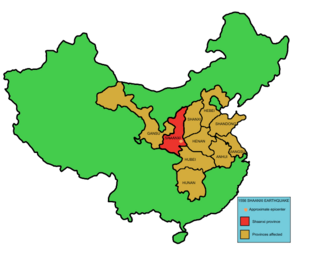
The 1556 Shaanxi earthquake, known in Chinese colloquially by its regnal year as the Jiajing Great Earthquake "嘉靖大地震" or officially by its epicenter as the Hua County Earthquake "华县地震", occurred in the early morning of 23 January 1556 in Huaxian, Shaanxi during the Ming dynasty.
The Saint Lawrence rift system is a seismically active zone paralleling the Saint Lawrence River. The rift system trends northeast and southwest and forms a half-graben that links the Ottawa-Bonnechere and the Saguenay grabens. The rift system extends more than 1,000 km (620 mi) along the Saint Lawrence valley from the Ottawa – Montreal area. Within the system, fault reactivation is believed to occur along late Proterozoic to early Paleozoic normal faults related to the opening of the Iapetus Ocean.
The 1663 Charlevoix earthquake occurred on February 5 in New France, and was assessed to have a moment magnitude of between 7.3 and 7.9. The earthquake occurred at 5:30 p.m. local time and was estimated to have a maximum perceived intensity of X (Extreme) on the Mercalli intensity scale. The main shock epicentre is suggested to have occurred along the Saint Lawrence River, between the mouth of the Malbaie River on the north and the mouth of the Ouelle River on the south. A large portion of eastern North America felt the effects. Landslides and underwater sediment slumps were a primary characteristic of the event with much of the destruction occurring near the epicentral region of the St. Lawrence estuary and also in the area of the Saguenay Graben.
The 1783 Calabrian earthquakes were a sequence of five strong earthquakes that hit the region of Calabria in southern Italy, the first two of which produced significant tsunamis. The epicenters form a clear alignment extending nearly 100 km from the Straits of Messina to about 18 km SSW of Catanzaro. The epicenter of the first earthquake occurred in the plain of Palmi. The earthquakes occurred over a period of nearly two months, all with estimated magnitudes of 5.9 or greater. Estimates of the total number of deaths lie in the range 32,000 to 50,000.
The 1966 Toro earthquake, or the 1966 Ruwenzori earthquake, occurred on March 20 at 01:42 UTC. The earthquake was located near the border between Uganda and the Democratic Republic of the Congo (DRC), to the south of Lake Albert. Some sources put the epicenter in Uganda while some put it in the Democratic Republic of the Congo. The earthquake had a magnitude of 6.8 and a maximum perceived intensity of VIII (Severe) on the Mercalli intensity scale.

The 1303 Hongdong earthquake occurred in Yuan dynasty of the Mongol Empire, on September 25. The shock was estimated to have a moment magnitude of 7.6 and it had a maximum Mercalli intensity of XI (Extreme). This was one of the most deadly earthquakes in China, in turn making it one of the top disasters in China by death toll.
The Afyon Province of western Turkey was struck by an earthquake measuring 6.5 on 3 February 2002 at 10:11 local time. It had a maximum felt intensity of VIII (Severe) on the Modified Mercalli intensity scale. It damaged hundreds of buildings and caused the deaths of 44 people and a further 318 injuries.
The 1988 Lancang–Gengma earthquakes, also known as the 11.6 earthquakes by the Chinese media were a pair of devastating seismic events that struck Lancang and Gengma counties, Yunnan, near the border with Shan State, Burma. The earthquake measured moment magnitude (Mw ) 7.0 and was followed 13 minutes later by a 6.9 Mw shock. These earthquakes were assigned a maximum China seismic intensity of IX and X, respectively. Between 748 and 939 people were killed; more than 7,700 were injured. Both earthquakes resulted in US$270 million in damage and economic losses. Moderately large aftershocks continued to rock the region, causing additional casualties and damage.
A major earthquake occurred during the rule of the Qing dynasty in Shandong Province on July 25, 1668. It had an estimated magnitude of 8.5, making it the largest historical earthquake in East China, and one of the largest to occur on land. An estimated 43,000 to 50,000 people were killed, and its effects were widely felt. Its epicenter may have been located between Ju and Tancheng counties, northeast of the prefecture-level city of Linyi in southern Shandong.
The 1739 Yinchuan–Pingluo earthquake rocked the northern Ningxia Hui Autonomous Region on January 3 with an epicenter in the prefecture-level city Shizuishan. The estimated magnitude 7.1–7.6 earthquake had a maximum intensity of XI on the Mercalli intensity scale, and killed about 50,000 residents and officials. It was widely felt; perceived in Shanxi, Shaanxi and Hebei provinces. Aftershocks persisted for more than two years with the largest being a 5.5 on February 13 that same year.
The 2021 Luxian earthquake was a damaging seismic event occurring in the early hours of September 16 at 04:33 China Standard Time. The surface wave magnitude (Ms ) 6.0 or moment magnitude (Mw ) 5.4 earthquake struck at a shallow depth of 7.5 km and severe shaking in an area of 4,000 square kilometers was assigned a maximum intensity of VIII on the China seismic intensity scale. Three people were killed and 146 injured when the earthquake struck Lu County, Luzhou, Sichuan Province. At least 36,800 buildings were affected, 7,800 of them seriously damaged or completely destroyed, causing about a quarter of a billion dollars worth of damage.
Western Henan and southern Shanxi in northern China were struck by an earthquake of estimated magnitude 6.8 on 23 October 1815. The epicentre was in Pinglu County in southernmost Shanxi, which was the worse affected area. It had a maximum felt intensity of IX (violent) on the Modified Mercalli scale. It caused the collapse of many houses and cave dwellings and led to the deaths of at least 13,000 people.
The 1626 Lingqiu earthquake had an epicentre in Lingqiu County, Shanxi Province during the Ming dynasty. The estimated surface wave magnitude (Ms ) 7.0 earthquake caused many buildings to collapse. Over 5,200 people were killed.
The 1923 Renda earthquake occurred on March 24 at 20:40 local time between the counties of Daofu and Luhuo in Sichuan, China. The estimated 7.3 earthquake was assigned a maximum modified Mercalli intensity scale rating of X (Extreme). Severe damage occurred in Sichuan, killing an estimated 4,800 people.
The Shanxi Rift System or Fen–Wei Rift System is a zone of active extensional tectonics that forms the eastern margin of the Ordos Block in northern China. The zone extends for at least 900 km (560 mi) and runs south-southwest to north-northeast. The individual rift basins that make up the rift system have an overall en echelon geometry, consistent with a right lateral sense of strike-slip displacement across the zone. The basins contain a thick sedimentary sequence of Neogene age, which ranges from 2.0 to 3.8 km in thickness. The rift system is continuous with the Weihe Basin to the southwest, which became active during the Paleogene. Rupture of the major normal faults that bound the Weihe and Shanxi rift basins has caused many large and damaging historical earthquakes, including the 1303 Hongdong, 1556 Shaanxi, 1626 Lingqiu, 1695 Linfen and 1815 Pinglu events.
The 1870 Charlevoix earthquake occurred on 20 October in the Canadian province of Quebec. It had a moment magnitude of 6.6 Mw and a Modified Mercalli intensity rating of X (Extreme). The town of Baie-Saint-Paul was seriously damaged by the event, with the loss of six lives. Effects from the earthquake were felt as far as Virginia and along the New England coast of the United States.
The 1038 Dingxiang earthquake devastated present-day Shanxi Province, northern China on 9 January. At least 32,300 people died across the province when the Ms 7.25 earthquake struck Dingxiang and Xinxian counties. In Xinzhou, about 19,742 people died and 5,655 were injured. More than 50,000 livestock also perished. About 759 were killed in Guoxian County and in present-day Taiyuan, 1,890 people died.


