
The 2002 Bou'in-Zahra earthquake occurred on 22 June 2002. The epicenter was near the city of Bou'in-Zahra in Qazvin Province, a region of northwestern Iran which is crossed by several major faults that is known for destructive earthquakes. The shock measured 6.5 on the scale, had a maximum Mercalli intensity of VIII (Severe), and was followed by more than 20 aftershocks. At least 230 people were killed and 1,500 more were injured.

The 2008 Yingjiang earthquakes were a series of major earthquakes ranging from surface wave magnitude (Ms) 4.1 to 5.9 that struck Yingjiang County, Yunnan province, China between August 19 and September 3. It caused 5 deaths, 21 serious injuries, and RMB 2.7 billion in direct economic damage. USGS put the magnitude of the strongest one to Mw 6.0.
The 1970 Tonghai earthquake occurred at with a moment magnitude of 7.1 and a maximum Mercalli intensity of X (Extreme). The strike-slip rupture originated on the Red River Fault, which had not experienced an earthquake above magnitude 7 since 1700, and affected Tonghai County, Yunnan province, China. At least 10,000 people were killed, making it one of the deadliest in its decade. The tremor caused between US$5 to $25 million in damage, felt over an area of 8,781 km2 (3,390 sq mi). In Hanoi, North Vietnam, almost 483 km (300 mi) from the epicenter, victims left their homes as the rupture rumbled through the city.

The 2003 Bingöl earthquake hit eastern Turkey with a moment magnitude of 6.4 and a maximum Mercalli intensity of IX (Violent) on 1 May at . The epicenter of this strike-slip earthquake was in Bingöl Province, 15 km north of Bingöl. At least 177 people were killed, and 625 buildings collapsed or suffered heavy damage in the affected region. Eighty-Four of the fatalities occurred when a dormitory block collapsed in a boarding school in Celtiksuyu.
The 2011 Yunnan earthquake was a 5.4 magnitude earthquake that occurred on 10 March 2011 at 12:58 CST, with its epicenter in Yingjiang County, Yunnan, People's Republic of China, near the Burmese border. A total of 26 people died and 313 were injured with 133 in serious condition. China's Xinhua reports that up to seven aftershocks, measuring up to a magnitude of 4.7, followed the initial quake, which caused a total of 127,000 people to be evacuated to nearby shelters. It joined over 1,000 other minor tremors that affected the region in the two preceding months. Following damage surveys, officials reported that 1,039 buildings were destroyed and 4,994 more were seriously damaged. The earthquake occurred one day before a much larger earthquake struck Japan that also formed a tsunami.

The 2011 Burma earthquake occurred with a magnitude 6.9 on 24 March. It had an epicenter in the eastern part of Shan State in Burma (Myanmar) with a hypocenter 10 km deep. It had two aftershocks, one of magnitude 4.8, another at magnitude 5.4, and two subsequent shocks at magnitude 5.0 and 6.2. The quake's epicentre was 70 miles (110 km) from the northern Thai city of Chiang Rai, north of Mae Sai and southeast of Kentung.

The Sagaing Fault is a major fault in Burma, a mainly continental right-lateral transform fault between the Indian Plate and Sunda Plate. It links the divergent boundary in the Andaman Sea with the zone of active continental collision along the Himalayan front. It passes through populated cities of Mandalay, Yamethin, Pyinmana, the capital Naypyidaw, Toungoo and Pegu before dropping off into the Gulf of Martaban, running for a total length of over 1200 kilometers.
The 2003 Zhaosu earthquake, also known as the Syumbinskoe earthquake, occurred on December 1 at 01:38 UTC. The epicenter was located in the Almaty Region, Kazakhstan, near the Sino–Kazakh border. The earthquake had a magnitude of 6.0 and had a maximum observed intensity of VII on the Medvedev–Sponheuer–Karnik scale. The epicenter was close to the Zhaosu County, Xinjiang, where 10 people were reported dead, 73 people injured, and more than 800 buildings collapsed. Some people were evacuated in Zhaosu. The earthquake occurred in the cold winter, and the 30 cm ground snow covered the roads in the mountainous region and hindered the relief work.
The 1925 Dali earthquake occurred at 14:42 UTC on 16 March. It had an estimated magnitude of 7.0 on the surface wave magnitude scale and a maximum perceived intensity of at least IX (Violent) on the Mercalli intensity scale. It had an epicenter in the province of Yunnan in southern China and killed an estimated 5,000 people.
On 7 September 2012, a series of earthquakes occurred in Yiliang County, Zhaotong, Yunnan. The two main shocks occurred at 11:19 and 12:16 China Standard Time. The earthquakes left 81 people dead and 821 injured. According to the officials, at least 100,000 people were evacuated and more than 20,000 houses were damaged.
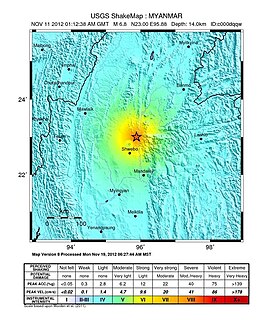
The 2012 Shwebo earthquake occurred at 07:42 local time on 11 November in Myanmar. It had a magnitude of 6.8 on the moment magnitude scale and a maximum perceived intensity of VIII (Severe) on the Mercalli intensity scale. The epicenter was near the town of Male, 52 km NNE of the city of Shwebo, 64 km west of Mogok and 120 km north of Mandalay. Significant damage and possible casualties have been reported from near the epicenter, with up to 26 people dead and many more injured. Part of a bridge under construction fell into the Irrawaddy River near Shwebo and a gold mine collapsed at Sintku. An aftershock with a magnitude of 5.8 followed at 17:24 local time.

The 2014 Mae Lao earthquake occurred at on May 5. The epicenter was located at a point 9 km (6 mi) south of Mae Lao District, 27 km (17 mi) southwest of Chiang Rai, Thailand. One person was killed as a result.

The 2014 Ludian earthquake struck Ludian County, Yunnan, China, with a moment magnitude of 6.1 on 3 August. The earthquake killed at least 617 people, injuring at least 2,400 others. As of 5 August 2014, 112 people remain missing. Over 12,000 houses collapsed and 30,000 were damaged. According to the United States Geological Survey, the earthquake occurred 29 km (18 mi) WSW of Zhaotong city at 16:03 local time (08:03 UTC).

The 2019 Eastern Samar Earthquake struck the islands of Visayas in the Philippines on April 23, 2019 at 1:37:51 PM(PHT).It had a moment magnitude of 6.5 and a local magnitude of 6.2 with a max intensity of VI based on the PHIVOLCS Earthquake Intensity Scale(PEIS). The epicenter was in San Julian, Eastern Samar and the hypocenter was at a depth of 64 km(~39.76 mi). As of April 30, 2019 there were 172 aftershocks ranging from magnitudes of 1.6 to 4.6. The earthquake did not result in any casualties but did injure 48 people and damaged about 245 homes.

The 2019 Cotabato earthquakes were an earthquake swarm which struck the province of Cotabato on the island of Mindanao in the Philippines in October 2019. Three of these earthquakes were above 6.0 on the moment magnitude scale with a Mercalli intensity of VIII. More than 40 people have been reported dead or missing and nearly 800 were injured as a result of these events.
At 14:11 PST on December 15, 2019, the province of Davao del Sur on the island of Mindanao in the Philippines was struck by an earthquake measuring 6.8 . It had a maximum perceived intensity of VII on the Modified Mercalli Intensity Scale. At least 13 people were killed and another 210 injured.

The 1988 Lancang–Gengma earthquakes, also known as the 11.6 earthquakes by the Chinese media were a pair of devastating seismic events which struck Lancang and Gengma counties, Yunnan, near the border with Shan State, Burma in the Shan Plateau. The pair of earthquakes occurred thirteen minutes apart with the first registering 7.7 on the moment magnitude scale and second measuring 7.2 on the surface wave magnitude scale. The two earthquakes were assigned their maximum Mercalli intensities of X (Extreme) and IX (Violent) respectively. At least 939 people were killed and more than 7,700 were injured in 20 counties across five prefectures in Yunnan, making it the worst in the country since the 1976 Tangshan earthquake. Both earthquakes resulted in US $270 million in damages and economical losses. Moderately large aftershocks continued to rock the region, causing additional casualties and damages. Much information about the earthquakes and its devastation were hidden by the Chinese government as the country was going through major political and cultural revolutions at the time.
The 2021 Maduo earthquake, also known as the 5.22 earthquake struck Madoi County in Qinghai Province, China on the morning of 22 May at 02:04 local time. The earthquake had a moment magnitude and surface-wave magnitude of 7.4, according to the Global Centroid Moment Tensor (GCMT) and the China Earthquake Administration (CEA) respectively. In the Qinghai, The earthquake caused no deaths but 19 people sustained minor injuries. Highway bridges, roads and walls collapsed as a result of the earthquake. According to non-government sources, however, at least twenty people were killed, 300 were injured, and 13 were missing. The earthquake was the strongest in China since the 2008 Sichuan earthquake. It was assigned intensity X in Machali town, Maduo County on the China seismic intensity scale, and X (Extreme) on the Modified Mercalli intensity scale. This earthquake was preceded by another unrelated earthquake; the 2021 Dali earthquake which had occurred 5 hours earlier in Yunnan.

The 1995 Menglian earthquake or 1995 Myanmar–China earthquake occurred on 12 July at 05:46:43 local time in the Myanmar–China border region. The earthquake had an epicenter on the Myanmar side of the border, located in the mountainous region of Shan State. It registered 7.3 on the Chinese surface wave magnitude scale (Ms ) and 6.8 on the moment magnitude scale (Mw ). With a maximum Mercalli intensity assigned at VIII, the quake killed eleven people and left another 136 injured. Over 100,000 homes in both countries were destroyed and 42,000 seriously damaged. Some damage to structures were also reported in Chiang Mai and Chiang Rai, Thailand. The low death toll from this earthquake was attributed to an early warning issued prior to it happening. Precursor events including foreshocks and some seismic anomalies led to an evacuation of the area before the mainshock struck. It is thought to be one of the few successfully predicted earthquakes in history.
