1932 Jalisco earthquakes

Last updated
1932 Jalisco earthquakes
Mexico relief location map.jpg
Bullseye1.png
UTC  time1932-06-03 10:36:58
ISC  event 906183
USGS-ANSS ComCat
Local dateJune 3, 1932 (1932-06-03)
Local time4:36:58 CST
Duration95 seconds [1]
Magnitude8.1 Mw [2]
Depth60 km (37 mi)
Epicenter 19°30′N104°15′W / 19.5°N 104.25°W / 19.5; -104.25 [2]
Areas affectedMexico
Guatemala [2]
Max. intensity X (Extreme)
Tsunamiyes
Casualties400+ [3]

The 1932 Jalisco earthquakes began on June 3 at 10:36 UTC with a megathrust event that registered 8.1 on the moment magnitude scale. [2] With a maximum perceived intensity of X (Extreme) on the Mercalli intensity scale, at least 400 deaths were caused in Mexico and neighboring Guatemala. [2] It was the first of a series of seismic events that affected parts of western Mexico during the month of June 1932, all reaching magnitude 7 or greater. [4]

Contents

The Mexican subduction zone, the Middle America Trench, is seismically active and has generated both destructive and non-destructive tsunamis. Each earthquake in the series caused significant damage, injuries, and deaths, and in each case tsunamis of various heights were generated, with the June 22 catastrophic tsunami in Cuyutlán and San Blas being described as one of the most destructive events in the region based on all available historical records. [5]

Tectonic setting

This part of Mexico lies on a complex convergent boundary where the Rivera Plate and the Cocos Plate are being subducted beneath the North American Plate. The transform boundary between the Rivera and Cocos Plates is poorly defined. This earthquake is thought to have ruptured the south-easternmost segment of the interface involving the Rivera Plate, [6] although it may also have affected the north-westernmost part of the Cocos-North American Plate interface. [7]

The complex subduction zone off the coast of Colima and Jalisco experiences large recurring earthquakes. Prior events occurred in 1806, 1818, and 1900, and a recurrence period of 77 years was proposed for the region, but because of difficulty in positively identifying the rupture zones, this time frame was not precisely established. [8] In 2003, near the same location, an earthquake with a magnitude of 7.6 claimed 29 lives.

Earthquake

The mainshock was preceded by a series of small foreshocks. [2] The rupture is thought to have initiated near Manzanillo, propagating to the northwest, although early reports from seismologists placed the epicenter farther southeast near the border of Oaxaca and Guerrero. [9] The length of the rupture is estimated to be about 220 km. [6] Seismometers located in New York, London, and Pasadena, California all measured the earthquake. [9]

Plate boundaries in the Pacific, offshore western Mexico Tectonic setting western Mexico.png
Plate boundaries in the Pacific, offshore western Mexico

Carlos Valdez, director of the National Seismology Center at the National Autonomous University of Mexico, called the earthquake the most powerful quake in modern Mexican history. [10]

Sequence

The initial earthquake of June 3 off of the coast of Colima and Jalisco caused extensive damage along western Mexico, with much of the deaths and injuries concentrated in the area of Guadalajara. Early reporting from the Los Angeles Times noted that there were 300 deaths or injuries in that area alone. [3]

Fifteen days after the first shock, June 18 at 4:15 am, there was a magnitude 7.7 event with an estimated rupture length of 60 kilometers (37 mi) and a duration of 22 seconds. [1] Similar patterns of damage occurred as in the first quake. This time the human loss was centered around the city of Colima with 3 deaths and twelve injured, with heavy damage reported in Manzanillo. [11] The low number of casualties may have been a result of many residents still sleeping outdoors since the previous quake. [11] The Governor of Colima's home partially collapsed, though he escaped injury. [12] The tsunami created from this event, reported to be 1 meter (3 ft 3 in) in height, was the smallest generated from the three June earthquakes. [13]

The final and smallest event occurred on June 22 with a magnitude 7 earthquake. A few minutes after the quake, there was a tsunami which resulted in the almost total destruction of the hotels and village homes in the city of Cuyutlán. [14] The wave(s) were reported to be up to 10 meters (33 ft) in height. [15] Up to 100 people were reported killed as the wave swept into the center of that small coastal village. [16] The port city of Manzanillo also saw heavy damage again, but early reports via messenger did not indicate any deaths in that area. [14] Both wired telegraph and radio communications were interrupted there. [11] As Governor Saucedo gathered reports of inadequate care for those affected in Cuyutlán following the destructive wave, he appealed to the Red Cross to fill gaps where federal and state aid were proving ineffective. [16] In the capital of Colima, where the residents were already recovering in their own neighborhoods, 2000 refugees were taken in from the wave swept coast. [16]

Tsunami

The earthquake triggered a tsunami that had a maximum run-up height of 3 m at Bahia San Pedrito in Manzanillo. The tsunami was also recorded at Apia, San Diego, Hilo and Honolulu. [17] Little damage was recorded from the tsunami other than the washing out of part of the railway line between Cuyutlán and Manzanillo and partial flooding of the port town of San Blas, Nayarit, [17] but no deaths occurred there. [18]

Damage

The earthquake caused significant damage and deaths in Colima, Ayotlán, Manzanillo, Cihuatlán, Zamora and Acatlán de Juárez. In Colima almost 3,000 houses were damaged. [2] The sixteenth century Guadalajara Cathedral also sustained damage in the quake. [10] Farther south in Mexico City several buildings toppled over and numerous cracks formed on the streets. [9]

Following the quake there were no communications coming in from the city of Oaxaca. [9] That city had suffered heavy damage the prior year in a magnitude 7.8 event, [4] and there was initial concern that there had been a repeat event with a high death toll centered in that area. [9]

See also

Related Research Articles

<span class="mw-page-title-main">Rivera Plate</span> Small tectonic plate off the west coast of Mexico

The Rivera Plate is a small tectonic plate located off the west coast of Mexico, just south of the Baja California Peninsula. It is bounded on the northwest by the East Pacific Rise, on the southwest by the Rivera Transform Fault, on the southeast by a deformation zone, and on the northeast by the Middle America Trench and another deformation zone.

The 2003 Colima earthquake occurred on 21 January with a moment magnitude of 7.6 and a maximum Mercalli intensity of VIII (Severe). The epicenter was located on the Pacific coast in the Mexican state of Colima. The earthquake was felt as far away as Mexico City and in southern parts of the United States.

The 2009 Swan Islands earthquake occurred on May 28 at 02:24:45 AM local time with a moment magnitude of 7.3 and a maximum Mercalli intensity of VII. The epicenter was located in the Caribbean Sea, 64 kilometres (40 mi) northeast of the island of Roatán, 19 miles northeast of Port Royal, Isla de Bahias, 15 miles northwest of Isla Barbaretta, and 130 kilometres (81 mi) north-northeast of La Ceiba. Three aftershocks followed the earthquake within magnitude 4 range.

The 1995 Colima–Jalisco earthquake occurred on October 9 at 15:35 UTC with a moment magnitude of 8.0 and a maximum Mercalli intensity of VIII (Severe). The shock occurred off the coast of Jalisco, Mexico, where a tsunami was triggered that affected a 200 km (120 mi) stretch of the coast. The earthquake could be felt in Mexico City and in high-rise buildings in Dallas and Houston. In Mexico, the Cihuatlan-Manzanillo was the most severely affected area. At least 49 people died and 100 were injured.

<span class="mw-page-title-main">1978 Miyagi earthquake</span>

The 1978 Miyagi earthquake occurred at 17:14 local time on 12 June. The epicentre was offshore of Miyagi Prefecture, Japan. It had a surface wave magnitude of 7.7, JMA magnitude 7.4, and triggered a small tsunami. The earthquake reached a maximum intensity of Shindo 5 in Sendai and caused 28 deaths and 1,325 injuries.

<span class="mw-page-title-main">Tsunami earthquake</span> Type of earthquake which triggers a tsunami of far-larger magnitude

In seismology, a tsunami earthquake is an earthquake which triggers a tsunami of significantly greater magnitude, as measured by shorter-period seismic waves. The term was introduced by Japanese seismologist Hiroo Kanamori in 1972. Such events are a result of relatively slow rupture velocities. They are particularly dangerous as a large tsunami may arrive at a coastline with little or no warning.

The 1941 Colima earthquake occurred on April 15 at 19:09 UTC. The epicenter was located in the State of Michoacán, Mexico.

The 1931 Oaxaca earthquake affected portions of southern Mexico on January 14 at 18:50 MST. It registered a magnitude of 8.0 on the surface wave magnitude scale and had a maximum perceived intensity of X (Extreme) on the Mercalli intensity scale.

The 1981 Playa Azul earthquake occurred on October 24, 1981, at 21:22 local time. It was located near Playa Azul, Michoacán, Mexico. The magnitude of the earthquake was Mw 7.2, or Ms 7.3. Three deaths were reported, two from Michoacán and one from Mexico City. Some buildings were damaged in both Michoacán and Mexico City. A small tsunami was registered in Acapulco with a maximum height of 9 cm.

The 1941 Andaman Islands earthquake struck the Andaman Islands on June 26 with a magnitude of 7.7 to 8.1. Details of this event are poorly known as much of Southeast Asia was in the turmoil of World War II. The quake caused severe damage in the Andaman Islands. The tsunami it triggered was reported along the Andaman and Nicobar Islands, India and British Ceylon. There may have been damage and deaths in Bangladesh, Myanmar, and Thailand due to the tsunami.

<span class="mw-page-title-main">2017 Chiapas earthquake</span> 8.2 Mw earthquake and tsunami off of Mexico and Guatemala

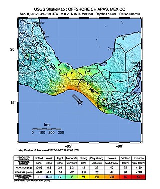
The 2017 Chiapas earthquake struck at 23:49 CDT on 7 September in the Gulf of Tehuantepec off the southern coast of Mexico near the state of Chiapas, approximately 87 kilometres (54 mi) southwest of Pijijiapan, with a Mercalli intensity of IX (Violent). The moment magnitude was estimated to be Mw8.2.

<span class="mw-page-title-main">2018 Swan Islands earthquake</span>

On 9 January 2018, at approximately 8:51 p.m. local time, a magnitude 7.5 earthquake struck in the Yucatán Basin of the Caribbean Sea, 44 kilometres (27 mi) east of Great Swan Island off the coast of Honduras. The earthquake was felt across Central America, and rattled windows in Tegucigalpa. The earthquake was also felt in the Cayman Islands.

<span class="mw-page-title-main">2013 Craig, Alaska earthquake</span> Earthquake in Alaska and British Columbia

The 2013 Craig, Alaska earthquake struck on January 5, at 12:58 am (UTC–7) near the city of Craig and Hydaburg, on Prince of Wales Island. The Mw 7.5 earthquake came nearly three months after an Mw  7.8 quake struck Haida Gwaii on October 28, in 2012. The quake prompted a regional tsunami warning to British Columbia and Alaska, but it was later cancelled. Due to the remote location of the quake, there were no reports of casualties or damage.

On January 30, 1973, at 15:01 (UTC–6), a magnitude 7.6 earthquake struck 35.3 km (21.9 mi) beneath the Sierra Madre del Sur range in the Mexican states of Colima, Jalisco and Michoacán. On the Mercalli intensity scale, the earthquake reached a maximum intensity of X (Extreme), causing serious damage in the region. At least 56 people were killed and about 390 were injured. The event is commonly referred to as the Colima earthquake.

The Nemuro-Oki earthquake in scientific literature, occurred on June 17 at 12:55 local time. It struck with an epicenter just off the Nemuro Peninsula in northern Hokkaidō, Japan. It measured 7.8–7.9 on the moment magnitude scale (Mw ), 8.1 on the tsunami magnitude scale (Mt ) and 7.4 on the Japan Meteorological Agency magnitude scale (MJMA ).

On April 13, 1923 at 15:31 UTC, an earthquake occurred off the northern coast of the Kamchatka Peninsula in the USSR, present-day Russia. The earthquake had a surface-wave magnitude (Ms ) of 6.8–7.3 and an estimated moment magnitude (Mw ) of 7.0–8.2. This event came just two months after a slightly larger earthquake with an epicenter struck south of the April event. Both earthquakes were tsunamigenic although the latter generated wave heights far exceeding that of the one in February. After two foreshocks of "moderate force", the main event caused considerable damage. Most of the 36 casualties were the result of the tsunami inundation rather than the earthquake.

<span class="mw-page-title-main">2021 Chignik earthquake</span> 7th largest earthquake in the US

An earthquake occurred off the coast of the Alaska Peninsula on July 28, 2021, at 10:15 p.m. local time. The large megathrust earthquake had a moment magnitude of 8.2 according to the United States Geological Survey (USGS). A tsunami warning was issued by the National Oceanic and Atmospheric Administration (NOAA) but later cancelled. The mainshock was followed by a number of aftershocks, including three that were of magnitude 5.9, 6.1 and 6.9 respectively.

The 2021 South Sandwich Islands earthquakes were a pair of powerful earthquakes, followed by many strong aftershocks which struck along the South Sandwich Trench in August 2021. The quakes measured 7.5 and 8.1 on the moment magnitude scale, according to the United States Geological Survey. The mainshock is tied with another event in 1929 as the largest earthquake ever recorded in this region, and is tied with the 2021 Kermadec Islands earthquake as the second largest earthquake of 2021.

The 1979 Petatlán earthquake, also known as the IBERO earthquake occurred on March 14 at 05:07 local time in the Mexican state of Guerrero. The earthquake had a surface wave magnitude of Ms  7.6 or moment magnitude of Mw  7.4 and maximum Modified Mercalli intensity of VIII (Severe). The epicenter, onshore, was located 12 km south southeast of Vallecitos de Zaragoza.

<span class="mw-page-title-main">2022 Michoacán earthquake</span> 2022 earthquake in Mexico

On 19 September 2022, a moment magnitude 7.7 earthquake struck between the Mexican states of Michoacán and Colima at 13:05:06 local time. The earthquake had a depth of 16.9 km (10.5 mi), resulting in a maximum intensity of VIII (Severe) on the Modified Mercalli intensity scale. The USGS reported the epicentre was 37 km (23 mi) southeast of the town of Aquila. Two people were killed and at least 35 others were injured across several states. A magnitude 6.8 aftershock struck on 22 September, causing three more deaths.

References

  1. 1 2 Pacheco et al. 1997, p. 2225
  2. 1 2 3 4 5 6 7 NGDC. "Significant earthquake". National Geophysical Data Center . Retrieved 19 December 2011.
  3. 1 2 "Quake Toll Increases; Mexican Victims Exceed 400", Los Angeles Times , June 5, 1932
  4. 1 2 Singh, S.K.; Pacheco J.F.; Alcántara L.; Reyes G.; Ordaz M.; Iglesias A.; Alcocer S.M.; Gutierrez C.; Valdés C.; Kostoglodov V.; Reyes C.; Mikumo T.; Quaas R. & Anderson J.G. (2003). "A Preliminary Report on the Tecomán, Mexico Earthquake of 22 January 2003 (Mw 7.4) and Its Effects". Seismological Research Letters. Seismological Society of America. 74 (3): 279–289. Bibcode:2003SeiRL..74..279S. doi:10.1785/gssrl.74.3.279 . Retrieved 22 December 2011.
  5. Farreras & Sanchez 1991 , pp. 301, 303
  6. 1 2 S. K. Singh; L. Ponce; S. P. Nishenko (October 1985). "The great Jalisco, Mexico, earthquakes of 1932: Subduction of the Rivera plate". Bulletin of the Seismological Society of America. Seismological Society of America. 75 (5): 1301–1313. Bibcode:1985BuSSA..75.1301S. doi:10.1785/BSSA0750051301.
  7. Eissler, H.K.; McNally, K.C. (1984). "Seismicity and Tectonics of the Rivera Plate and Implications For the 1932 Jalisco, Mexico, Earthquake". Journal of Geophysical Research. American Geophysical Union. 89 (B6): 4520–4530. Bibcode:1984JGR....89.4520E. doi:10.1029/JB089iB06p04520. Archived from the original on 2 March 2012. Retrieved 19 December 2011.
  8. Pacheco et al. 1997 , p. 2223
  9. 1 2 3 4 5 "Many Injured in Mexico; At Least Twenty-three Die as Tremors Shake Large Section of Country; Buildings Fall and Streets Crack in Capital, With People in Terror", Los Angeles Times , June 4, 1932
  10. 1 2 Mark Fineman; Kenneth Reich (October 10, 1995). "Dozens Die as 7.6 Quake Hits Mexico's West Coast : Latin America: Temblor brings down resort hotel in Manzanillo. Two-minute tremor rattles nerves in capital". Los Angeles Times . Retrieved 2011-12-21.
  11. 1 2 3 "Fears Rise For City In Quake Area; Manzanillo Shut Off and Gale Disaster Suspected; Three Dead in Temblor", Los Angeles Times , June 20, 1932
  12. "Many Lives Feared Lost as Quakes Shake Mexico", Los Angeles Times , June 19, 1932
  13. Farreras & Sanchez 1991 , p. 303
  14. 1 2 "Thirty Die in Wave; Town in Mexico Swept by Sea; Scores Missing After Tidal Flood and Earthquakes Strike Cuytlan; Colima Officials Rush Relief; Casualties Evacuated; Rail Line Wrecked", Los Angeles Times , June 23, 1932
  15. Farreras & Sanchez 1991 , pp. 303, 304
  16. 1 2 3 "Stricken Area Pleads for Aid; Quake-Torn. Wave-swept Colima Demoralized; Governor Asks for Help of World Red Cross; Pestilence and Resultant Death Toll Feared", Los Angeles Times , June 24, 1932
  17. 1 2 NGDC. "Tsunami Event". National Geophysical Data Center . Retrieved 19 December 2011.
  18. "Quakes Laid To Volcano Under Sea; Tidal Waves Follow in Wake of Temblors That Shook Mexican Areas", Los Angeles Times , June 6, 1932
Bibliography