
The 1946 Aleutian Islands earthquake occurred near the Aleutian Islands, Alaska on April 1, 1946. The shock had a moment magnitude (Mw ) of 8.6, a tsunami magnitude Mt of 9.3, and a surface-wave magnitude (Ms ) of only 7.4, and a maximum Mercalli intensity of VI (Strong). It resulted in 165–173 casualties and over $26 million in damage. The seafloor along the fault was elevated, triggering a Pacific-wide tsunami with multiple destructive waves at heights ranging from 45–138 ft (14–42 m). The tsunami obliterated the Scotch Cap Lighthouse on Unimak Island, Alaska among others, and killed all five lighthouse keepers. Despite the destruction to the Aleutian Island Unimak, the tsunami had almost an imperceptible effect on the Alaskan mainland.
The 1938 Banda Sea earthquake occurred on February 2 with an estimated magnitude of 8.5–8.6 on the moment magnitude scale and a Rossi–Forel intensity of VII. This oblique-slip event generated destructive tsunamis of up to 1.5 metres in the Banda Sea region, but there were no deaths.
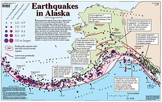
The Queen Charlotte Fault is an active transform fault that marks the boundary of the North American plate and the Pacific plate. It is Canada's right-lateral strike-slip equivalent to the San Andreas Fault to the south in California. The Queen Charlotte Fault forms a triple junction south with the Cascadia subduction zone and the Explorer Ridge. The Queen Charlotte Fault (QCF) forms a transpressional plate boundary, and is as active as other major transform fault systems in terms of slip rates and seismogenic potential. It sustains the highest known deformation rates among continental or continent-ocean transform systems globally, accommodating greater than 50mm/yr dextral offset. The entire approximately 900 km offshore length has ruptured in seven greater than magnitude 7 events during the last century, making the cumulative historical seismic moment release higher than any other modern transform plate boundary system.
The 1995 Antofagasta earthquake occurred on July 30 at 05:11 UTC with a moment magnitude of 8.0 and a maximum Mercalli intensity of VII. The Antofagasta Region in Chile was affected by a moderate tsunami, with three people killed, 58 or 59 injured, and around 600 homeless. Total damage from the earthquake and tsunami amounted to $1.791 million.
Striking the Autonomous Region of Azores on 1 January, the 1980 Azores Island earthquake killed 61 people and injured over 400, causing severe damage on the islands of Terceira and São Jorge. Measuring 6.9 on the moment magnitude scale, it also shook the islands of Pico and Faial, and resulted from a strike slip fracture, typical of other historical Azorean earthquakes.
The 1996 Biak earthquake, or the Irian Jaya earthquake, occurred on 17 February at near Biak Island, Indonesia. The earthquake, which occurred on the New Guinea Trench, had a moment magnitude of 8.2 and a maximum Mercalli intensity of IX (Violent). The run-up height of the generated tsunami reached 7.7 m (25 ft). The disaster left at least 108 people dead, 423 injured, and 58 missing. It damaged or destroyed 5,043 houses which subsequently made another 10,000 homeless. At Korim, 187 houses were destroyed. Various countries and organizations provided aid and relief in the aftermath of the earthquake.
The 1984 Northern Sumatra earthquake occurred with a moment magnitude of 7.2 on November 17 at 06:49 UTC. The epicentre was located off the coast of Sumatra, near the island of Nias, where building damage was reported. This earthquake could be strongly felt in parts of Northern Sumatra, including Padang and Medan. The focal mechanism corresponded to reverse faulting.

The 1994 offshore Sanriku earthquake occurred on December 28, 1994, at 12:19 UTC. This was a magnitude 7.7 earthquake with epicenter located in the Pacific Ocean at about 180 km east of Hachinohe, Aomori. The intensity reached shindo 6 in Hachinohe, Aomori, about 187.6 km from epicenter. It could be felt in Tokyo, about 632.9 km from epicenter, with shindo 2. The Japanese Meteorological Agency put the magnitude at 7.5. Slip associated with this earthquake continued for more than a year and it has been termed an 'ultra-slow earthquake'.
The 1906 Aleutian Islands earthquake occurred at 00:11 UTC on August 17. It had an estimated seismic moment of 3.8 x 1028 dyn cm−1, equivalent to a magnitude of 8.35 on the moment magnitude scale. This earthquake was followed thirty minutes later by the 1906 Valparaíso earthquake in Chile, but the two events are not thought to be linked. Due to the remote location, there are no reports of damage associated with this earthquake. A transpacific tsunami reported from Japan and Hawaii was triggered by the Chilean event, rather than the Aleutian Islands earthquake.
The 1981 Playa Azul earthquake occurred on October 24, 1981, at 21:22 local time. It was located near Playa Azul, Michoacán, Mexico. The magnitude of the earthquake was 7.2, or 7.3. Three deaths were reported, two from Michoacán and one from Mexico City. Some buildings were damaged in both Michoacán and Mexico City. A small tsunami was registered in Acapulco with a maximum height of 9 cm.
The 2006 Mozambique earthquake occurred at 22:19 UTC on 22 February. It had a magnitude of 7.0 on the moment magnitude scale and caused 4 deaths and 36 injuries. The epicenter was near Machaze in Manica Province of southern Mozambique, just north of the Save River. It was the largest historical earthquake in Mozambique and the first earthquake in southern Africa to have an identified surface rupture.
The 1988 Myanmar–India earthquake, also known as the Indo–Burma earthquake struck the Sagaing Region of Myanmar, about 30 kilometres (19 mi) from the border with India on 6 August at 7:06 am MMT with a moment magnitude (Mw ) of 7.3 or Richter magnitude (ML ) of 7.5. At least five people were killed, more than 30 were injured, and another 30 were missing as a result. Serious damage was reported in India and Bangladesh, while some minor damage occurred in Myanmar. The earthquake was reportedly felt in the Soviet Union.
On January 30, 1973, at 15:01 (UTC–6), a magnitude 7.6 earthquake struck 35.3 km (21.9 mi) beneath the Sierra Madre del Sur range in the Mexican states of Colima, Jalisco and Michoacán. On the Mercalli intensity scale, the earthquake reached a maximum intensity of X (Extreme), causing serious damage in the region. At least 56 people were killed and about 390 were injured. The event is commonly referred to as the Colima earthquake.
The 1761 Lisbon earthquake and its subsequent tsunami occurred in the north Atlantic Ocean and south of the Iberian Peninsula. This violent shock which struck just after noon on 31 March 1761, was felt across many parts of Western Europe. Its direct effects were even observed far north in Scotland and Amsterdam, and to the south in the Canary Islands of Spain. The estimated surface-wave magnitude 8.5 event was the largest in the region, and the most significant earthquake in Europe since the Great Lisbon earthquake of 1755.
The Nemuro-Oki earthquake in scientific literature, occurred on June 17 at 12:55 local time. It struck with an epicenter just off the Nemuro Peninsula in northern Hokkaidō, Japan. It measured 7.8–7.9 on the moment magnitude scale (Mw ), 8.1 on the tsunami magnitude scale (Mt ) and 7.4 on the Japan Meteorological Agency magnitude scale (MJMA ).

An earthquake occurred off the coast of the Alaska Peninsula on July 28, 2021, at 10:15 p.m. local time. The large megathrust earthquake had a moment magnitude of 8.2 according to the United States Geological Survey (USGS). A tsunami warning was issued by the National Oceanic and Atmospheric Administration (NOAA) but later cancelled. The mainshock was followed by a number of aftershocks, including three that were of magnitude 5.9, 6.1 and 6.9 respectively.
The 1816 North Atlantic earthquake occurred on 2 February somewhere between the Azores Islands and Lisbon, Portugal. The estimated moment magnitude 8.3–8.9 earthquake had an epicenter offshore in the Atlantic Ocean, and was felt in Lisbon at 00:40 local time. Little is known about the quake, but it is believed to be one of the largest to have struck the Atlantic.
The 1979 Saint Elias earthquake occurred near noon local time on the 28th of February. It measured Mw 7.4–7.6. Though the maximum recorded Modified Mercalli intensity was VII, damage was minimal and there were no casualties due to the remoteness of the faulting. The epicenter lies near the Alaskan border between America and Canada.

The 1940 Shakotan earthquake occurred on August 2 at 00:08:22 JST with a moment magnitude (Mw ) of 7.5 and maximum JMA seismic intensity of Shindo 4. The shock had an epicenter off the coast of Hokkaido, Japan. Damage from the shock was comparatively light, but the accomanying tsunami was destructive. The tsunami caused 10 deaths and 24 injuries on Hokkaido, and destroyed homes and boats across the Sea of Japan. The highest tsunami waves were recorded at the coast of Russia while along the coast of Hokkaido, waves were about 2 m.
