1975 Kinnaur earthquake

Last updated

1975 Kinnaur earthquake
India relief location map.jpg
Bullseye1.png
UTC  time1975-01-19 08:02:02
ISC  event 733389
USGS-ANSS ComCat
Local date19 January 1975 (1975-01-19)
Local time13:32:02
Magnitude6.8 Ms
Depth33 km
Epicenter 32°28′N78°26′E / 32.46°N 78.43°E / 32.46; 78.43 Coordinates: 32°28′N78°26′E / 32.46°N 78.43°E / 32.46; 78.43 [1]
Type Normal
Areas affected India, Himachal Pradesh
Max. intensity IX (Violent)
Casualties47
Key Monastery and the Spiti Valley, seriously affected by the Kinnaur earthquake Ki Monastery.jpg
Key Monastery and the Spiti Valley, seriously affected by the Kinnaur earthquake

The 1975 Kinnaur earthquake occurred in the early afternoon (local time) (08:02 UTC) of 19 January. It had a magnitude of 6.8 on the surface wave magnitude scale and a maximum perceived intensity of IX (Violent) on the Mercalli intensity scale, causing extensive damage in Himachal Pradesh, in northern India. [2] [3] Its epicentre was in Kinnaur district in the southeastern part of Himachal Pradesh and caused 47 casualties. [2] Landslides, rock falls and avalanches caused major damage to the Hindustan-Tibet Road. [2] The earthquake affected many monasteries and buildings in the state and led to an extensive restoration work in the late 1970s and early 1980s in Himachal Pradesh. The Spiti and Parachu valleys in particular suffered the greatest damage being on the north–south Kaurik-Chango fault, [2] causing damage to landmarks such as Key Monastery and Tabo Monastery.

Contents

Tectonic setting

The state of Himachal Pradesh lies towards the southern boundary of the Himalayan mountain belt, which was formed by the collision between the Indian Plate and the Eurasian Plate. The mountain building that formed the Himalayas is an example of thrust tectonics and is dominated by thrust faulting. [4] There is however, a significant amount of extension along the length of the mountain belt, possibly related to its arcuate form, with the extension accommodating the bulging out of the frontal part of the Himalayas. However, the faulting in the NW Himalayas demonstrates west–east extension, which is at a fairly high angle to the trend of the main thrust structures and may be better explained as partly accommodating the eastward spreading of the Tibetan Plateau. [5] One of the most significant extensional structures in Himachal Pradesh is the Kaurik-Chango Fault Zone. This is interpreted to be seismically active from the presence of thermal springs and gypsum deposits [6] and from studies of soft-sediment deformation structures thought to be seismites. These seismites have been used to suggest eight earlier earthquakes of magnitude greater than 6 in the Sumdo area affecting these Late Pleistocene to Holocene sediments. [7] The estimated recurrence interval for earthquakes along this fault zone is about 10,000 years. [8]

Earthquake

The earthquake rupture is estimated to be about 25 kilometres (16 mi) in length and 575 square kilometres (222 sq mi) in area, with a displacement of about 0.6 metres (2 ft 0 in). The mainshock was preceded by a major foreshock. [3] Ground rupture was observed in the form of a series of small vertical faults, with downthrow to the west, offsetting part of National Highway 22 between Sumdo and Kaurik, with displacements up to 50 cm. [7]

The isoseismal lines for the earthquake are elongated in a north–south direction, parallel to the strike of the Kaurik-Chango Fault Zone. The focal mechanism of the earthquake indicates normal faulting along with a north–south-trending, west-dipping fault. [3] [5]

Damage

The areas most strongly affected by the earthquake were the districts of Kinnaur and Lahaul-Spiti. The worst-affected villages were in the Parachu and Spiti river valleys. The village of Karauk showed the greatest degree of damage, with no building being unaffected. Buildings sited on slopes or at the base of slopes were not only affected by the shaking but by boulders falling from the hills above them. [6] The performance of the different types of residential buildings varied greatly. Houses made from mud, either directly or as sun-dried bricks showed damage over a wide area (up to 100 kilometres (62 mi) from the epicentre) and those in the epicentral area were often severely damaged. Unreinforced masonry structures were also badly affected, particularly those made of "random rubble stone masonry" (RRSM) with mud mortar, some of them have collapsed completely. The best performing buildings were barrack type houses constructed from corrugated iron covering a timber frame, which generally showed little or no damage. [6]

The many monasteries and temples in the area were mostly badly damaged. They were often constructed with mudbrick or RRSM walls and had heavy roofs. [6] Strong vertical motion during the earthquake led to excessive loads on the upper part of the supporting walls causing them to bulge outwards. [9]

There were many landslides, rockfalls and avalanches triggered by the earthquake. [6] One landslide dammed the Parachu river to a height of 60 metres (200 ft), forming a lake that caused flash flooding when it burst two months later. [10]

Aftermath

Damaged temples and monasteries were repaired or rebuilt immediately after the earthquake. [9] The Guru Ghantal monastery at Tupchiling, which was completely destroyed in the earthquake, was rebuilt using stone masonry and cement mortar. The roof, which was originally wooden, although it had already been replaced by slates by 1975, now consists of corrugated iron sheets. [11] The original design of these earthen buildings had already evolved to contain elements of earthquake resistance before the damage in 1975. The walls were reinforced using ring beams around the whole structure to prevent outward displacement during an earthquake. Further reinforcement was in some cases provided by buttresses of stone or brick at each corner of the building. Initial repairs after the earthquake by the local people involved additional corner buttresses, replacement wooden roofs and repair of the upper walls with stone masonry. Most of these repairs, however, have either caused further problems or may do so in the future. [9]

See also

Related Research Articles

<span class="mw-page-title-main">Lahaul and Spiti district</span> District of Himachal Pradesh in India

The Lahaul and Spiti district in the Indian state of Himachal Pradesh consists of the two formerly separate districts of Lahaul and Spiti. The present administrative center is Kyelang in Lahaul. Before the two districts were merged, Kardang was the capital of Lahaul, and Dhankar the capital of Spiti. The district was formed in 1960 and is the fourth least populous district in India. It is the least densely populated district of India, according to the Census of India 2011.

<span class="mw-page-title-main">Kinnaur district</span> District of Himachal Pradesh in India

Kinnaur district is one of the twelve administrative districts of the state of Himachal Pradesh in northern India. The district is divided into three administrative areas and has six tehsils. The administrative headquarters of the district is at Reckong Peo. The mountain peak of Kinnaur Kailash is found in this district. As of 2011, it is the second least populous district of Himachal Pradesh, after Lahaul and Spiti.

<span class="mw-page-title-main">Tabo, Himachal Pradesh</span> Town and village in Himachal Pradesh, India

Tabo is a small town in the Lahaul and Spiti district on the banks of the Spiti River in Himachal Pradesh, India. The town lies on the road between Rekong Peo and Kaza, the sub-divisional headquarters of Spiti. The town surrounds a Buddhist monastery which, according to legend, is said to be over a thousand years old. The Dalai Lama has expressed his desire to retire to Tabo, since he maintains that the Tabo Monastery is one of the holiest. In 1996, the Dalai Lama conducted the Kalachakra initiation ceremony in Tabo, which coincided with the millennium anniversary celebrations of the Tabo monastery. The ceremony was attended by thousands of Buddhists from across the world. Tabo Monastery's spiritual head is Tsenshap Serkong Rinpoche.

<span class="mw-page-title-main">Geography of Himachal Pradesh</span>

The state of Himachal Pradesh is spread over an area 55,673 km2 (21,495 sq mi) and is bordered by Jammu and Kashmir and Ladakh on the north, Punjab on the southwest, Haryana on the south, Uttarakhand on the southeast, a small border with Uttar Pradesh in the south, and Tibet on the east. Entire Himachal Pradesh lies in the mountainous Himalaya region, rich in natural resources

<span class="mw-page-title-main">Spiti</span> River valley in Himachal Pradesh

Spiti is a high-altitude region of the Himalayas, located in the north-eastern part of the northern Indian state of Himachal Pradesh. The name "Spiti" means "The middle land", i.e. the land between Tibet and India. Spiti incorporates mainly the valley of the Spiti River, and the valleys of several rivers that feed into the Spiti River. Some of the prominent side-valleys in Spiti are the Pin valley and the Lingti valley. Spiti is bordered on the east by Tibet, on the north by Ladakh, on the west and southwest by Lahaul, on the south by Kullu, and on the southeast by Kinnaur. Spiti has a cold desert environment. The valley and its surrounding regions are among the least populated regions of India. The Bhoti-speaking local population follows Tibetan Buddhism.

The 1999 Chamoli earthquake occurred on 29 March in the Chamoli district in the Indian state of Uttar Pradesh. Approximately 103 people died in the earthquake.

<span class="mw-page-title-main">Manirang</span>

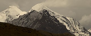
Manirang is one of the highest mountains in the Indian state Himachal Pradesh. It lies on the border between Kinnaur district and Lahaul and Spiti district. Close to the peak is the high Manirang pass, which was one of the early trade routes between Spiti and Kinnaur, before the motorable road was built. The trail over the pass starts from Mane Yogma on the Spiti side and runs to the Ropa valley in Kinnaur.

<span class="mw-page-title-main">Nako, Himachal Pradesh</span> Village in Himachal Pradesh, India

Nako is a village in the Himalayas of northern India, located near the Indo-China border in the Trans-Himalayan region of Kinnaur district in Himachal Pradesh. Nako Lake is a prominent feature here where it borders the village. Nako Monastery, dated to 1025, is located in the village as well as several other Buddhist chortens.

<span class="mw-page-title-main">Kaza, Himachal Pradesh</span> Town in Himachal Pradesh, India

Kaza, also spelled Kaze, Karze, Karzey, is a town and the subdivisional headquarters of the remote Spiti Valley in the western Himalayas in the Lahaul and Spiti district of the northern Indian state of Himachal Pradesh. Spiti is a high altitude or cold desert having close similarities to the neighbouring Tibet and Ladakh regions in terms of terrain, climate and the Buddhist culture. Kaza, situated along the Spiti River at an elevation of 3,650 m (11,980 ft) above mean sea level, is the largest township and commercial center of the Spiti valley.

The 1991 Uttarkashi earthquake occurred at 02:53:16 Indian Standard Time (UTC+05:30) on 20 October with a moment magnitude of 6.8 and a maximum Mercalli intensity of IX (Violent). This thrust event was instrumentally recorded and occurred along the Main Central Thrust in the Uttarkashi and Gharwal regions of the Indian state of Uttarakhand. High intensity shaking resulted in the deaths of at least 768 people and the destruction of thousands of homes.

<span class="mw-page-title-main">Tabo Monastery</span> Tibetan Buddhist monastery in Tabo, Himachal Pradesh, India

Tabo Monastery is located in the Tabo village of Spiti Valley, Himachal Pradesh, northern India. It was founded in 996 CE in the Tibetan year of the Fire Ape by the Tibetan Buddhist lotsawa (translator) Rinchen Zangpo, on behalf of the king of western Himalayan Kingdom of Guge, Yeshe-Ö. Tabo is noted for being the oldest continuously operating Buddhist enclave in both India and the Himalayas. A large number of frescoes displayed on its walls depict tales from the Buddhist pantheon. There are many priceless collections of thankas, manuscripts, well-preserved statues, frescos and extensive murals which cover almost every wall. The monastery is in need of refurbishing as the wooden structures are aging and the thanka scroll paintings are fading. After the earthquake of 1975, the monastery was rebuilt, and in 1983 a new Du-kang or Assembly Hall was constructed. It is here that the 14th Dalai Lama held the Kalachakra ceremonies in 1983 and 1996. The monastery is protected by the Archaeological Survey of India (ASI) as a national historic treasure of India.

<span class="mw-page-title-main">Lhalung Monastery</span>

Lhalung Monastery, Lhalun Monastery or Lalung Monastery, was one of the earliest monasteries founded in Spiti, Himachal Pradesh, India, by the great Tibetan Buddhist lotswa (translator) Rinchen Zangpo, the king of western Himalayan Kingdom of Guge during the late 10th century CE. The altitude of the neighbouring village of Lhalun is 3,658 metres.

<span class="mw-page-title-main">Gemur Monastery</span>

Gemur Monastery is a Buddhist gompa, above the village of Gemur, Lahaul and Spiti district, Himachal Pradesh, northern India. The monastery dates from the first half of the 17th century.

<span class="mw-page-title-main">Buddhism in Himachal Pradesh</span>

Buddhism in the Himachal Pradesh state of India of has been a long-recorded practice. The spread of Buddhism in the region has occurred intermediately throughout its history. Starting in the 3rd century BCE, Buddhism was propagated by the Maurya Empire under the reign of Ashoka. The region would remain an important center for Buddhism under the Kushan Empire and its vassals. Over the centuries the following of Buddhism has greatly fluctuated. Yet by experiencing revivals and migrations, Buddhism continued to be rooted in the region, particularly in the Lahaul, Spiti and Kinnaur valleys.

<span class="mw-page-title-main">Spiti Horse</span> Indian breed of horse

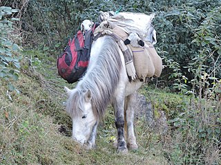
The Spiti Horse is a breed of small mountain horse or pony from Himachal Pradesh in northern India. It takes its name from the Spiti River, and is found mainly in the Kullu, Lahaul and Spiti and Kinnaur districts of the state.

<span class="mw-page-title-main">National Highway 505 (India)</span> National Highway in Himachal Pradesh, India

National Highway 505, commonly called NH 505, is a national highway in India. It is a spur road of National Highway 5. NH-505 traverses the state of Himachal Pradesh in India. NH505 a high elevation road, covers Kinnaur and Lahaul and Spiti districts of Himachal Pradesh, mainly running along Spiti river in Spiti valley. The highway from Kaza to Gramphu remains closed for 6–9 months in a year due to heavy snowfall and closure of Kunzum La pass at an elevation of 4,550 m (14,930 ft).

<span class="mw-page-title-main">Gue (Lahul and Spiti)</span> Village in Lahul and Spiti District, Himachal Pradesh, India

Gue is a village in the Lahul & Spiti district of the state of Himachal Pradesh in India. In this little village lays the perfectly well-preserved 593-year-old mummy of Sangha Tenzing. It was a Buddhist monk from Tibet. It was found in a sitting position, with his skin and hair intact. The village is about 40 km from the Tabo Monastery. The latitude 31.11 and longitude 77.16 are the geocoordinate of the Gue. Current Gue is controlled by India but claimed by Zanda County, Ngari Prefecture, Tibet, China.

Kaurik and is village in the Lahul and Spiti district, in Himachal Pradesh, India. It is in the valley of the Parang or Pare Chu river before its confluence with the Spiti River. Kaurik is close to the border with Tibet, the opposite village on the Tibetan side being Tsurup Sumgyi. China claims the village as part of its Zanda County, Tibet.

<span class="mw-page-title-main">Mud village, Spiti</span> Village in Himachal Pradesh, India

Mud is a small village in the cold desert region of Spiti in Himachal Pradesh, India. Located at an altitude of 3,810 m (12,500 ft) on the left bank of the Pin River, a right bank tributary of the Spiti River, the village nestles at the base of the Parbati range that towers almost vertically 1,600 m (5,200 ft) above. Mud is near the boundary of the Pin Valley National Park and is a convenient base for treks in the park, and to the neighbouring districts of Kullu and Kinnaur. It is the last village on the Spiti side of the Pin Parbati trek to Kullu and the Pin Bhaba trek to Kinnaur.

The 1555 Kashmir earthquake occurred at around midnight in the month of Ashvin in the Hindu calendar, or September in the Gregorian calendar, although the exact day of occurrence is not known. The earthquake seriously impacted the Kashmir Valley in present-day Pakistan and northwestern India. A moment magnitude (Mw ) of 7.6 to 8.0 and Modified Mercalli intensity of XII (Extreme) has been estimated for the earthquake. Thought to be one of the most destructive in the Kashmir Valley, the earthquake caused serious widespread damage and ground effects, killing an estimated 600–60,000 individuals.

References

  1. NGDC. "Comments for the Significant Earthquake" . Retrieved 27 August 2010.
  2. 1 2 3 4 The Kinnaur earthquake of January 19, 1975: A field report. Seismological Society of America, June 1976; v. 66; no. 3; pp. 887–901.
  3. 1 2 3 Khattri, K.; Rai K.; Jain A.K.; Sinvhal H.; Gaur V.K. & Mithal R.S. (1978). "The Kinnaur earthquake, Himachal Pradesh, India, of 19 January, 1975". Tectonophysics. 49 (1–2): 1–21. Bibcode:1978Tectp..49....1K. doi:10.1016/0040-1951(78)90095-1.
  4. Mugnier, J.L.; Huyghe, P.; Leturny, P.; Jouanne F. (2004). "Episodicity and rates of thrust-sheet motion in the Himalayas (Western Nepal)". In McClay K.R. (ed.). Thrust tectonics and hydrocarbon systems. Memoir. Vol. 82. AAPG. pp. 91–92. ISBN   978-0-89181-363-7 . Retrieved 6 December 2013.
  5. 1 2 Hintersberger, E.; Thiede R.C.; Strecker M.R. & Hacker B.R. (2010). "East-west extension in the NW Indian Himalaya". Geological Society of America Bulletin. 122 (9/10): 1499–1515. Bibcode:2010GSAB..122.1499H. doi:10.1130/B26589.1.
  6. 1 2 3 4 5 Singh, S.; Jain A.K.; Singh V.N. & Srivastava L.S. "Damage during Kinnaur Earthquake of January 19, 1975, in Himachal Pradesh, India" (PDF). pp. 184–190. Retrieved 1 December 2011.
  7. 1 2 Mohindra, R.; Bagati T.N. (1996). "Seismically induced soft-sediment deformation structures (seismites) around Sumdo in the lower Spiti valley (Tethys Himalaya)". Sedimentary Geology. 101 (1–2): 69–83. Bibcode:1996SedG..101...69M. doi:10.1016/0037-0738(95)00022-4.
  8. Singh, S.; Jain A.K. (2007). "Liquefaction and fluidization of lacustrine deposits from Lahaul-Spiti and Ladakh Himalaya: Geological evidences of paleoseismicity along active fault zone". Sedimentary Geology . 196 (1–4): 47–57. Bibcode:2007SedG..196...47S. doi:10.1016/j.sedgeo.2006.06.005.
  9. 1 2 3 Sikka, S.; Chaudhry C. "Research on the Upgrade of Traditional Seismic Retrofits for Ancient Buddhist Temples in the Region of Spiti and Kinnaur in the Western Himalayas" (PDF). The Getty Conservation Institute. pp. 109–119. Archived from the original (PDF) on 26 April 2012. Retrieved 2 December 2011.
  10. Himachal SoE (2006). "Natural Disasters and Climate Change" (PDF). p. 130. Archived from the original (PDF) on 27 February 2012. Retrieved 2 December 2011.
  11. Handa, O.C. (2004). Buddhist Monasteries of Himachal (2nd ed.). Indus Publishing. pp. 125–126. ISBN   978-81-7387-170-2.