
Kutch district is a district of Gujarat state in western India, with its headquarters (capital) at Bhuj. Covering an area of 45,674 km², it is the largest district of India. The area of Kutch District is larger than the entire area of states like Haryana (44,212 km2) and Kerala (38,863 km2) The population of Kutch is about 2,092,371. It has 10 talukas, 939 villages and 6 municipalities. The Kutch district is home to the Kutchi people who speak the Kutchi language.
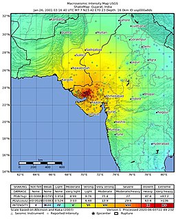
The 2001 Gujarat earthquake, also known as the Bhuj earthquake, occurred on 26 January, India's 52nd Republic Day, at . The epicentre was about 9 km south-southwest of the village of Chobari in Bhachau Taluka of Kutch District of Gujarat, India.

Bhuj is a Municipality and District Headquarters of Kutch District in the state of Gujarat, India.

Anjar is a town, a tehsil and a municipality in the Kachchh district in the state of Gujarat, India. It is a town of historic importance, located in Southern Kachchh, around 40 km away from one of the biggest ports in India, Kandla Port. Founded around 650 AD, with nearly 1,400 years of history, Anjar is claimed to be the oldest town in Kachchh.

Gandhidham is a developed, largest and most populous city in Kutch District, Gujarat, India. It was created in the early 1950s for the resettlement of Sindhi Hindu refugees from Sindh in the aftermath of the partition of India. It was named after Mahatma Gandhi, the father of the Indian nation. An economic capital of Kutch and a growing area for families and retirees, it is Gujarat's 8th most populous city. It is a popular destination for conventions, business, and meetings.
Rapar is a city and a municipality in Kutch district in the Indian state of Gujarat. Particularly this area of Kutch is called 'Vagad'. The name derives from famous Vaghela rulers.it means the land of Vaghelas.
Galpadar is a village in the Gandhidham Municipal Corporation, within the Kutch District of the Gujarat State of India. It is located at a distance of about 3 km from Gandhidham, 11 km from Anjar and 51 km from Bhuj.
Ratnal is a village near the town of Anjar in the Anjar taluka of Kutch district in the Indian state of Gujarat. It is located around 15 kilometres (9.3 mi) from Anjar and 25 kilometres (16 mi) from Bhuj capital of Kutch.
Tuna Port is a port town in Anjar taluka of Kutch District of Gujarat State of India.

The Sagaing Fault is a major fault in Burma, a mainly continental right-lateral transform fault between the Indian Plate and Sunda Plate. It links the divergent boundary in the Andaman Sea with the zone of active continental collision along the Himalayan front. It passes through populated cities of Mandalay, Yamethin, Pyinmana, the capital Naypyidaw, Toungoo and Pegu before dropping off into the Gulf of Martaban, running for a total length of over 1200 kilometers.
The 2012 Negros earthquake occurred on February 6 at , with a body wave magnitude of 6.7 and a maximum intensity of VII (Destructive) off the coast of Negros Oriental, Philippines. The epicenter of the thrust fault earthquake was approximately 72 kilometres (45 mi) north of the provincial capital of Dumaguete City.

The 1819 Rann of Kutch earthquake occurred at about 18:45 to 18:50 local time on 16 June. It had an estimated magnitude ranging from 7.7 to 8.2 on the moment magnitude scale and a maximum perceived intensity of XI (Extreme) on the Mercalli intensity scale. It triggered a tsunami and caused at least 1,543 deaths. The earthquake caused an area of subsidence that formed the Sindri Lake and a local zone of uplift to the north about 80 km long, 6 km wide and 6 m high that dammed the Koree / Kori / Puran / Nara river. This natural dam was known as the Allah Bund.

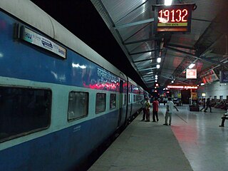
Gandhidham Junction railway station, located in Gandhidham, Gujarat, India, serves the people residing in Gandhidham and Kandla areas.

The Gandhidham–Bhuj section belongs to Western Railway of Kutch district in Gujarat state. It passes through Adipur and Anjar
The Gandhidham–Samakhiali section is a rail line belonging to the Western Railway of Kutch district in Gujarat state, India. It passes through Bhimasar, Chirai and Bhachau.
The Gandhidham–Ahmedabad main line belongs to Western Railway of Ahmedabad Division in Gujarat State.
The 1994 Mascara earthquake occurred on August 18 at 02:13 local time with an epicenter in the Tell Atlas. Despite the moderate size of the earthquake, measuring 5.8 on the moment magnitude scale, and 5.6 on the local magnitude scale, it caused the deaths of 171 people and left 8,000 to 10,000 homeless. Reaching a maximum intensity of VIII (Damaging) on the MSK 64 scale, the earthquake was far more devastating for its size, destroying or damaging many homes.
On 9 July 2019, at 8:36 PM (PST), an earthquake measuring 5.6 jolted the province of North Cotabato, Davao del Sur, and other nearby provinces. The National Disaster Risk Reduction and Management Council reported one dead and three injured in Makilala after the earthquake, and a total of 164 families affected in Cotabato Province. Near the epicenter of the earthquake, the severity of strong ground motion was assigned VI (Strong) on the Modified Mercalli intensity scale. A total of 106 schools, 119 houses, and 14 other infrastructures were damaged by the earthquake.
On February 7, 2021, at 12:22 PM PST, an earthquake measuring Mw 6.1 rocked Davao del Sur and Cotabato. The event registered a Modified Mercalli Intensity Scale (MMI) of VIII (Severe) with VII on the PHIVOLCS Earthquake Intensity Scale (PEIS).
The 1870 Charlevoix earthquake occurred on 20 October in the Canadian province of Quebec. It had a moment magnitude of 6.6 Mw and a Modified Mercalli intensity rating of X (Extreme). The town of Baie-Saint-Paul was seriously damaged by the event, with the loss of six lives. Effects from the earthquake were felt as far as Virginia and along the New England coast of the United States.
