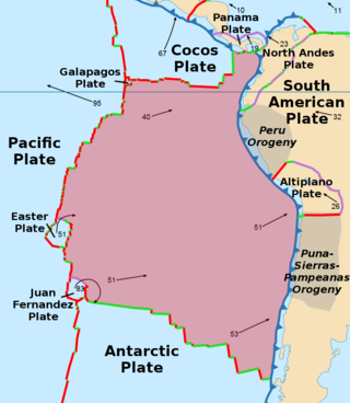
The Nazca Plate or Nasca Plate, named after the Nazca region of southern Peru, is an oceanic tectonic plate in the eastern Pacific Ocean basin off the west coast of South America. The ongoing subduction, along the Peru–Chile Trench, of the Nazca Plate under the South American Plate is largely responsible for the Andean orogeny. The Nazca Plate is bounded on the west by the Pacific Plate and to the south by the Antarctic Plate through the East Pacific Rise and the Chile Rise respectively. The movement of the Nazca Plate over several hotspots has created some volcanic islands as well as east–west running seamount chains that subduct under South America. Nazca is a relatively young plate both in terms of the age of its rocks and its existence as an independent plate having been formed from the break-up of the Farallon Plate about 23 million years ago. The oldest rocks of the plate are about 50 million years old.
The Peru–Chile Trench, also known as the Atacama Trench, is an oceanic trench in the eastern Pacific Ocean, about 160 kilometres (99 mi) off the coast of Peru and Chile. It reaches a maximum depth of 8,065 m (26,460 ft) below sea level in Richards Deep and is approximately 5,900 km (3,666 mi) long; its mean width is 64 km (40 mi) and it covers an expanse of some 590,000 km2 (230,000 sq mi).

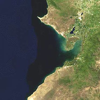
The Gulf of Guayaquil is a large body of water of the Pacific Ocean in western South America. Its northern limit is the city of Santa Elena, in Ecuador, and its southern limit is Cabo Blanco, in Peru.


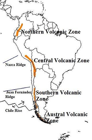
The Andean Volcanic Belt is a major volcanic belt along the Andean cordillera in Argentina, Bolivia, Chile, Colombia, Ecuador, and Peru. It is formed as a result of subduction of the Nazca Plate and Antarctic Plate underneath the South American Plate. The belt is subdivided into four main volcanic zones which are separated by volcanic gaps. The volcanoes of the belt are diverse in terms of activity style, products, and morphology. While some differences can be explained by which volcanic zone a volcano belongs to, there are significant differences within volcanic zones and even between neighboring volcanoes. Despite being a type location for calc-alkalic and subduction volcanism, the Andean Volcanic Belt has a broad range of volcano-tectonic settings, as it has rift systems and extensional zones, transpressional faults, subduction of mid-ocean ridges and seamount chains as well as a large range of crustal thicknesses and magma ascent paths and different amounts of crustal assimilations.

The Nazca Ridge is a submarine ridge, located on the Nazca Plate off the west coast of South America. This plate and ridge are currently subducting under the South American Plate at a convergent boundary known as the Peru-Chile Trench at approximately 7.7 cm (3.0 in) per year. The Nazca Ridge began subducting obliquely to the collision margin at 11°S, approximately 11.2 Ma, and the current subduction location is 15°S. The ridge is composed of abnormally thick basaltic ocean crust, averaging 18 ±3 km thick. This crust is buoyant, resulting in flat slab subduction under Peru. This flat slab subduction has been associated with the uplift of Pisco Basin and the cessation of Andes volcanism and the uplift of the Fitzcarrald Arch on the South American continent approximately 4 Ma.
The 1949 Ambato earthquake was the deadliest earthquake in the Western Hemisphere in five years. On August 5, 1949, it struck Ecuador's Tungurahua Province southeast of its capital Ambato and killed 5,050 people. Measuring 6.4 on the scale, it originated from a hypocenter 15 km beneath the surface. The nearby villages of Guano, Patate, Pelileo, and Pillaro were destroyed, and the city of Ambato suffered heavy damage. The earthquake flattened buildings and subsequent landslides caused damage throughout the Tungurahua, Chimborazo, and Cotopaxi Provinces. It disrupted water mains and communication lines and opened a fissure into which the small town of Libertad sank. Moderate shaking from the event extended as far away as Quito and Guayaquil.
The 1797 Riobamba earthquake occurred at 12:30 UTC on 4 February. It devastated the city of Riobamba and many other cities in the Interandean valley, causing between 6,000–40,000 casualties. It is estimated that seismic intensities in the epicentral area reached at least XI (Extreme) on the Mercalli intensity scale, and that the earthquake had a magnitude of 7.6–8.3, the most powerful historical event known in Ecuador. The earthquake was studied by Prussian geographer Alexander von Humboldt, when he visited the area in 1801–1802.

The 1868 Ecuador earthquakes occurred at 19:30 UTC on August 15 and 06:30 UTC on 16 August 1868. They caused severe damage in the northeastern part of Ecuador and in southwestern Colombia. They had an estimated magnitude of 6.3 and 6.7 and together caused up to 70,000 casualties. The earthquake of 15 August occurred near El Ángel, Carchi Province, close to the border with Colombia, while that of August 16 occurred near Ibarra in Imbabura Province. Reports of these earthquakes are often confused with the effects of the earthquake of 13 August at Arica.
The 1998 Bahía de Caráquez earthquake occurred on August 4 at 13:59 local time with a magnitude 7.2. The epicenter was located at 10 km north of Bahía de Caráquez, about 190 km NNW of Guayaquil, and about 215 km W of Quito, Ecuador. The intensity in Bahía de Caráquez reached MM VIII. In Bahía de Caráquez, electricity, telephone, and water services disrupted, and many buildings were damaged. It was felt strongly in Guayaquil and Quito and could be felt in much of Ecuador and in Cali, Colombia. An Mw 5.4 foreshock occurred 1 hour and 24 minutes before the main shock and hence alerted many people. The Nazca Plate is subducting beneath the South American Plate near the Ecuadorian coast. This earthquake was a shallow thrust earthquake in this subduction zone.
The 1979 Tumaco earthquake occurred at on 12 December with a moment magnitude of 8.2 and a maximum Mercalli intensity of IX (Violent). The epicenter was just offshore from the border between Ecuador and Colombia, near the port city of Tumaco. It triggered a major tsunami, which was responsible for most of the estimated 300–600 deaths. The hardest hit area was Colombia's Nariño Department.
The 1942 Peru earthquake occurred on August 24 at and was located near the border of the departments of Ica and Arequipa, Peru. It had a magnitude of 8.2 or 8.4.

Flat slab subduction is characterized by a low subduction angle beyond the seismogenic layer and a resumption of normal subduction far from the trench. A slab refers to the subducting lower plate. A broader definition of flat slab subduction includes any shallowly dipping lower plate, as in western Mexico. Flat slab subduction is associated with the pinching out of the asthenosphere, an inland migration of arc magmatism, and an eventual cessation of arc magmatism. The coupling of the flat slab to the upper plate is thought to change the style of deformation occurring on the upper plate's surface and form basement-cored uplifts like the Rocky Mountains. The flat slab also may hydrate the lower continental lithosphere and be involved in the formation of economically important ore deposits. During the subduction, a flat slab itself may deform or buckle, causing sedimentary hiatus in marine sediments on the slab. The failure of a flat slab is associated with ignimbritic volcanism and the reverse migration of arc volcanism. Multiple working hypotheses about the cause of flat slabs are subduction of thick, buoyant oceanic crust (15–20 km) and trench rollback accompanying a rapidly overriding upper plate and enhanced trench suction. The west coast of South America has two of the largest flat slab subduction zones. Flat slab subduction is occurring at 10% of subduction zones.
An earthquake measuring 8.0 struck Peru and the surrounding areas on 26 May 2019 at 02:41 local time. It had a maximum perceived intensity of VII on the Modified Mercalli intensity scale in the towns of Yurimaguas and Lagunas. Two people died and a further 30 were injured. It was the strongest earthquake in 2019 by magnitude.
The 1942 Ecuador earthquake or the Guayaquil earthquake occurred on 13 May at 9:06 or 9:13 pm local time with a moment magnitude of Mw 7.9. The temblor struck the coastal (Esmeraldas) region of Manabí Province, Ecuador. It caused damage mainly to cities like Guayaquil, Portoviejo and Guaranda. More than 300 people were killed and the total cost of damage was about US$2.5 million. Ecuador's largest city Guayaquil was the most affected despite the significant distantce from the epicenter. Many reinforced concrete structures in a particular area in the city were completely destroyed, contributing to fatalities.
The 1604 Arica earthquake is an earthquake that occurred at 1:30 pm on November 24, 1604, offshore Arica, Chile. The estimated magnitude range is 8.0–8.5 and possibly up to 9.0 . It had a destructive tsunami that destroyed Arica and caused major damage at Arequipa. 1,200 km of coastline were affected by the tsunami. The recorded effects of this earthquake are very similar to those for the 1868 Arica event, suggesting a similar magnitude and rupture area of the megathrust between the subducting Nazca Plate and the overriding South American Plate. Tsunami deposits have been identified on the Chatham Islands that are likely to have been caused by a trans-Pacific tsunami caused by the 1604 earthquake.

Oblique subduction is a form of subduction for which the convergence direction differs from 90° to the plate boundary. Most convergent boundaries involve oblique subduction, particularly in the Ring of Fire including the Ryukyu, Aleutian, Central America and Chile subduction zones. In general, the obliquity angle is between 15° and 30°. Subduction zones with high obliquity angles include Sunda trench and Ryukyu arc.

The Chile Ridge, also known as the Chile Rise, is a submarine oceanic ridge formed by the divergent plate boundary between the Nazca Plate and the Antarctic Plate. It extends from the triple junction of the Nazca, Pacific, and Antarctic plates to the Southern coast of Chile. The Chile Ridge is easy to recognize on the map, as the ridge is divided into several segmented fracture zones which are perpendicular to the ridge segments, showing an orthogonal shape toward the spreading direction. The total length of the ridge segments is about 550–600 km.
A strong earthquake struck southern Ecuador on 18 March 2023. It measured 6.8 on the moment magnitude scale, and struck with a hypocenter 65.8 km (40.9 mi) deep. The epicenter was located in the Gulf of Guayaquil, just off the coast of the canton of Balao and some 80 kilometres (50 mi) south of the city of Guayaquil. It caused major damage, with 446 injuries and 16 fatalities in the provinces of El Oro, Azuay and Guayas, while two additional fatalities and dozens of injuries were reported in Peru.


