1996 Pacific Northwest floods

Last updated
1996 Pacific Northwest floods
Pacific Northwest Flood of 1996 (24526655880).jpg
Flooding in the Willamette Valley in 1996.
DateFebruary 1996
Location Washington, Oregon, and Idaho in the United States
Property damage$700-$800 million ($1.4 billion in 2021) [1] [2]

The 1996 Pacific Northwest floods were a series of floods in Washington, Oregon, and the Idaho Panhandle in the United States. Large portions of the Columbia River and Puget Sound watersheds were impacted, including the Portland, Yakima, and the Palouse region. The flood was largely caused by warm temperatures and heavy rain falling on significant snowpack and caused an estimated $800 million in damage (1996 value). [3] [1]

Contents

Meteorological synopsis

The winter of 1995-96 started with near to below average snowpack for much of the affected region with ski resorts opening later than usual. [4] The weather pattern changed a few weeks later, producing significant snowfall in lowland areas. Moscow, Idaho recorded 42 inches (110 cm) of snow in ten days during the second half of January. [5] Prolonged cold settled in following the heavy snow, causing the ground to freeze throughout much of the Columbia Basin and surrounding valleys. In places where the ground wasn't frozen, it was generally saturated with water. [6]

In early February, a storm developed near Java and moved eastward. It was picked up by the jet stream and funneled toward the Pacific Northwest, reaching the region as a pineapple express, a name applied to atmospheric rivers observed on the U.S. and Canadian west coast that are sourced in the tropical or subtropical Pacific Ocean. La Niña conditions with a ridge of high pressure over the Rocky Mountains and an Aleutian Low helped to drive the moisture into Washington and Oregon rather than into California. [3] [5] The moisture reached Washington and Oregon on February 6 and on the 8th, Seattle observed its wettest February day with 3.06 inches (78 mm) of rain at the airport. [7] [8] With soils in many places either frozen or saturated, water resulting from rain falling on snowpack was unable to seep into the ground, instead remaining on the surface causing flooding. [5]

Flood and Damage

Flooding on the Columbia River itself was largely mitigated due to dams and other flood control measures taken after the 1948 Columbia River flood, though a few blocks in Vancouver were evacuated. [3] [9] Projects completed on a few smaller waterways in the 1960s were also successful in limiting flooding, such as the concrete channel dug for the Palouse River in Colfax, Washington after the Christmas flood of 1964. It is estimated that flood control infrastructure in the Willamette Valley prevented additional damage around $1.1 billion (1996 value) in Portland alone. [7] Flooding was common elsewhere. [5]

Western Washington & Oregon

A McDonald's sign submerged in floodwater in Oregon. Pacific Northwest Flood of 1996 (24822181235).jpg
A McDonald's sign submerged in floodwater in Oregon.

The Willamette River crested at 28.6 feet (8.7 m) in Portland on February 9, reaching major flood stage and causing some flooding issues in lowlying parts of the city, including the Northwest Industrial Area. Sandbags were placed along the downtown seawall to prevent flooding, but the river came a few inches short of overtopping the lowest sections. [10] [11] Further upstream, cities from Oregon City to Corvallis were impacted by rising waters on the Willamette River and Oregon Department of Agriculture was forced to temporarily relocate to a new facility in the Salem area. [7] [12] The water reached so high in Oregon City that Willamette Falls almost disappeared. [13] Several rivers flowing west out of the Oregon Coast Range into the Pacific also flooded. The dairy industry in Tillamook County with 500 cattle having drowned and sediment left behind covering about a quarter of the grazing land in the county. [14]

Southwest Washington saw significant impacts. Near Centralia and Chehalis, Interstate 5 was covered by up to 10 feet (3.0 m) of water and the dike built to protect the Chehalis-Centralia Airport overflowed. The Skookumchuck River reached a new record high discharge, with the Chehalis River and Cowlitz River also getting well above flood stage. [15] Further south, a mudslide near Woodland also closed Interstate 5. [9]

Numerous roads were washed out in King County. One man died when he drove into a 40 feet (12 m) deep hole left behind when the road he was driving on was destroyed. Parts of Kent and Renton flooded and a landslide caused a house in Tacoma to slide into the Tacoma Narrows. [9] Because of its position between the Puget Sound and Lake Washington, Seattle did not experience significant flooding though the city was unable to draw water from the Cedar River because of the amount of sediment in the river. [16]

Inland Northwest

About 11 inches (280 mm) of rain fell on the east side of Snoqualmie Pass in three days, causing the Yakima River to rise. Similar values were recorded near the headwaters of the Naches River, a tributary of the Yakima, with most communities from Nile in the Cascade Mountains to Toppenish taking damage. Visitors to a country club in Yakima were stranded when an ice jam blocked the river and cut off access, requiring military vehicles to be used in the evacuation. Interstate 82 near Granger was closed for flooding, and sediment entering the Naches River from one of its tributaries forced the closure of State Route 410. [17]

Near Milton-Freewater to the south of Walla Walla, Mill Creek rose to the point where helicopters had to be used to evacuate people. [18] Four levees in St. Maries, Idaho broke from high water and damage from ice. U.S. Route 95 and U.S. Route 12 were closed in Idaho. Tug boats had to be used on Lake Coeur d'Alene to keep a restaurant boat from floating away from its dock. The University of Idaho closed after some housing on campus was flooded by Paradise Creek. [5]

Response

U.S. President Bill Clinton speaking in Portland, Oregon while touring flood damaged areas. Pacific Northwest Flood of 1996 (24195344733).jpg
U.S. President Bill Clinton speaking in Portland, Oregon while touring flood damaged areas.

The National Guard was deployed in each of the affected states to help with flood relief efforts. [5] U.S. President Bill Clinton visited Boise, Idaho and the greater Portland area to tour flood damage and meet with both victims and local officials. He also issued a disaster declaration for parts of the Pacific Northwest. During the flooding, the U.S. Army Corps of Engineers used night-vision goggles to watch dikes. [1]

Yakima County created a flood control district in 1998 to mitigate flood risk there. Among the projects was the removal of a scrapyard south of Union Gap to expand a bridge allowing for a wider floodplain. Previous to this, floodwaters would get backed up and rush into Wapato and Toppenish as occurred in 1996. Other agencies also made improvements to the Yakima River, including by widening the area between levees and constructing a new bridge for State Route 24, both near Yakima. [17]

Environmental groups and scientists in Oregon lobbied for wetland and flood plain restoration along the Willamette River. Existing dams and other infrastructure provided examples of how far flood control in the region had come during the 20th Century, but it was not considered feasible to build more. The Army Corps of Engineers was directed by Congress to conduct a study of how successful such a program would be, which was still ongoing as recently as 2021. [3]

See also

Related Research Articles

<span class="mw-page-title-main">Columbia River</span> River in the Pacific Northwest of North America

The Columbia River is a major river which flows through southern British Columbia, central Washington and forms a portion of the Washington - Oregon boundary before emptying into the Pacific Ocean. It is the largest river in the Pacific Northwest region of the United States. The river rises in the Rocky Mountains of British Columbia, Canada. It flows northwest and then south into the U.S. state of Washington, then turns west to form most of the border between Washington and the state of Oregon before emptying into the Pacific Ocean. The river is 1,243 miles long, and its largest tributary is the Snake River. Its drainage basin is roughly the size of France and extends into seven of the United States plus a Canadian province. The fourth-largest river in the United States by volume, the Columbia has the greatest flow of any North American river entering the Pacific. The Columbia has the 36th greatest discharge of any river in the world.

<span class="mw-page-title-main">Willamette River</span> 187-mile Columbia River tributary in northwest Oregon, US

The Willamette River is a major tributary of the Columbia River, accounting for 12 to 15 percent of the Columbia's flow. The Willamette's main stem is 187 miles (301 km) long, lying entirely in northwestern Oregon in the United States. Flowing northward between the Oregon Coast Range and the Cascade Range, the river and its tributaries form the Willamette Valley, a basin that contains two-thirds of Oregon's population, including the state capital, Salem, and the state's largest city, Portland, which surrounds the Willamette's mouth at the Columbia.

<span class="mw-page-title-main">Chehalis River (Washington)</span> River in Washington state, United States

The Chehalis River is a river in Washington in the United States. It originates in several forks in southwestern Washington, flows east, then north, then west, in a large curve, before emptying into Grays Harbor, an estuary of the Pacific Ocean.

<span class="mw-page-title-main">Eastern Oregon</span> Geographic and cultural region of the U.S. state of Oregon

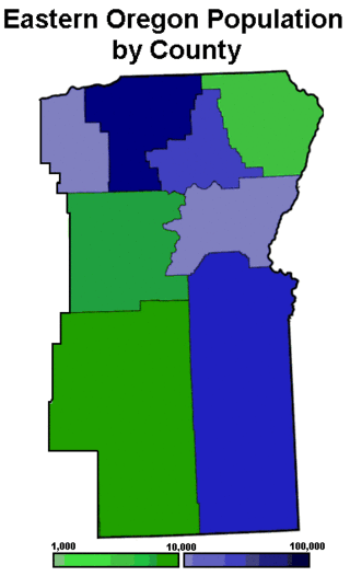
Eastern Oregon is the eastern part of the U.S. state of Oregon. It is not an officially recognized geographic entity; thus, the boundaries of the region vary according to context. It is sometimes understood to include only the eight easternmost counties in the state; in other contexts, it includes the entire area east of the Cascade Range. Cities in the basic eight-county definition include Baker City, Burns, Hermiston, Pendleton, Boardman, John Day, La Grande, and Ontario. Umatilla County is home to the largest population base in Eastern Oregon; accounting for 42% of the region's residents. Hermiston, located in Umatilla County, is the largest city in the region, accounting for 10% of Eastern Oregon's residents. Major industries include transportation/warehousing, timber, agriculture and tourism. The main transportation corridors are I-84, U.S. Route 395, U.S. Route 97, U.S. Route 26, U.S. Route 30, and U.S. Route 20.

<span class="mw-page-title-main">Interstate 84 (Oregon–Utah)</span> Interstate Highway in the U.S. states of Oregon, Idaho, and Utah

Interstate 84 (I-84) is an Interstate Highway in the northwestern United States. The highway runs from Portland, Oregon, to a junction with I-80 near Echo, Utah. The highway serves and connects Portland, Boise, and Ogden, Utah. With connections to other highways, I-84 connects these cities to points east and also serves as part of a corridor between Seattle and Salt Lake City. The sections running through Oregon and Idaho are also known as the Vietnam Veterans Memorial Highway.

<span class="mw-page-title-main">Willamette Valley flood of 1996</span> Series of floods in the Pacific Northwest of the United States, particularly in Oregon

The Willamette Valley flood of 1996 was part of a larger series of floods in the Pacific Northwest of the United States which took place between late January and mid-February 1996. It was Oregon's largest flood event in terms of fatalities and monetary damage during the 1990s. The floods spread beyond Oregon's Willamette Valley, extending west to the Oregon Coast and east toward the Cascade Mountains. Significant flood damage also impacted the American states of Washington, Idaho and California. The floods were directly responsible for eight deaths in Oregon, as well as over US$500 million in property damage throughout the Pacific Northwest. Three thousand residents were displaced from their homes.

<span class="mw-page-title-main">Sullivan's Gulch, Portland, Oregon</span> Neighborhood in Portland, Oregon, United States

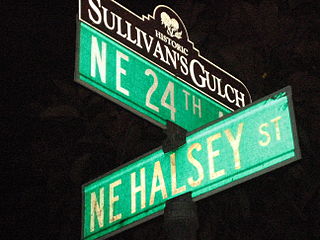
Sullivan's Gulch is a neighborhood in the Northeast section of Portland, Oregon. The name commemorates Timothy Sullivan, an early farmer in the area. Sullivan settled his donation land claim on January 27, 1851. He was born in Ireland in 1805, received citizenship in the United States in 1855, and most likely received title to the claim around 1863.

<span class="mw-page-title-main">Great Coastal Gale of 2007</span> Storm in the United States and Canada

The Great Coastal Storm of 2007 was a series of three powerful Pacific storms that affected the U.S. states of Oregon and Washington and the Canadian province of British Columbia between December 1, 2007 and December 4, 2007.

<span class="mw-page-title-main">Umtanum Ridge Water Gap</span> Geologic feature in Washington, United States

Umtanum Ridge Water Gap is a geologic feature in Washington state in the United States. It includes the Yakima Canyon, and is located between the cities of Ellensburg and Yakima in central Washington. Washington State Route 821 was once the main route between Ellensburg and Yakima. The old highway still runs close to the river through the canyon, with Interstate 82 currently carrying most traffic between Ellensburg and Yakima on large bridges nearby.

<span class="mw-page-title-main">U.S. Route 12 in Washington</span> Section of U.S. Highway in Washington, United States

U.S. Route 12 is a major east–west U.S. Highway, running from Aberdeen, Washington, to Detroit, Michigan. It spans 430.8 miles across the state of Washington, and is the only numbered highway to span the entire state from west to east, starting near the Pacific Ocean, and crossing the Idaho state line near Clarkston. It crosses the Cascade Range over White Pass, south of Mount Rainier National Park. Portions of it are concurrent with Interstate 5 (I-5) and Interstate 82 (I-82), although the majority of the route does not parallel any interstate highway.

<span class="mw-page-title-main">Balch Creek</span> Tributary of Willamette River

Balch Creek is a 3.5-mile (5.6 km) tributary of the Willamette River in the U.S. state of Oregon. Beginning at the crest of the Tualatin Mountains, the creek flows generally east down a canyon along Northwest Cornell Road in unincorporated Multnomah County and through the Macleay Park section of Forest Park, a large municipal park in Portland. At the lower end of the park, the stream enters a pipe and remains underground until reaching the river. Danford Balch, after whom the creek is named, settled a land claim along the creek in the mid-19th century. After murdering his son-in-law, he became the first person legally hanged in Oregon.

<i>Enterprise</i> (1855)

The Enterprise was an early steamboat operating on the Willamette River in Oregon and also one of the first to operate on the Fraser River in British Columbia. This vessel should not be confused with the many other vessels, some of similar design, also named Enterprise. In earlier times, this vessel was sometimes called Tom Wright's Enterprise after one of her captains, the famous Tom Wright.

<span class="mw-page-title-main">Ice Age Floods National Geologic Trail</span>

The Ice Age Floods National Geologic Trail is a network of routes connecting natural sites and facilities that provide interpretation of the geological consequences of the Glacial Lake Missoula floods of the last glacial period that occurred about 18,000 to 15,000 years ago. It includes sites in Washington, Oregon, Idaho, and Montana. It was designated as the first National Geologic Trail in the United States in 2009.

<span class="mw-page-title-main">Christmas flood of 1964</span> Major flood in the United States

The Christmas flood of 1964 was a major flood in the United States' Pacific Northwest and some of Northern California between December 18, 1964, and January 7, 1965, spanning the Christmas holiday. Considered a 100-year flood, it was the worst flood in recorded history on nearly every major stream and river in coastal Northern California and one of the worst to affect the Willamette River in Oregon. It also affected parts of southwest Washington, Idaho, and Nevada. In Oregon, 17 or 18 people died as a result of the disaster, and it caused hundreds of millions of dollars in damage. The flooding on the Willamette covered 152,789 acres (61,831.5 ha). The National Weather Service rated the flood as the fifth most destructive weather event in Oregon in the 20th century. California Governor Pat Brown was quoted as saying that a flood of similar proportions could "happen only once in 1,000 years," and it was often referred to later as the Thousand Year Flood. The flood killed 19 people, heavily damaged or completely devastated at least 10 towns, destroyed all or portions of more than 20 major highway and county bridges, carried away millions of board feet of lumber and logs from mill sites, devastated thousands of acres of agricultural land, killed 4,000 head of livestock, and caused $100 million in damage in Humboldt County, California, alone.

<span class="mw-page-title-main">Willamette Valley</span> Valley in the Pacific Northwest region of the United States

The Willamette Valley is a 150-mile (240 km) long valley in Oregon, in the Pacific Northwest region of the United States. The Willamette River flows the entire length of the valley and is surrounded by mountains on three sides: the Cascade Range to the east, the Oregon Coast Range to the west, and the Calapooya Mountains to the south.

<i>Jennie Clark</i> American steamboat

Jennie Clark, also seen spelled Jenny Clark, was the first sternwheel-driven steamboat to operate on the rivers of the Pacific Northwest, including British Columbia. This vessel was commonly known as the Jennie when it was in service. The design of the Jennie Clark set a pattern for all future sternwheel steamboats built in the Pacific Northwest and in British Columbia.

<span class="mw-page-title-main">Badger Mountain (Benton County, Washington)</span> Mountain in Washington (state), United States

Badger Mountain is a small mountain in Richland, Washington. Badger rises above the Tri-Cities connected to the smaller Candy Mountain via Goose Gap, is visible throughout much of the area and is a popular hiking destination for a wide variety of climbers. There are a number of trails climbing the mountain with varying levels of difficulty. Most of Badger Mountain is protected by the Badger Mountain Centennial Preserve, but the radio towers at the peak are private property. There are two summits on Badger Mountain, named the East Summit and the West Summit. The West Summit is the highest.

<span class="mw-page-title-main">1948 Columbia River flood</span> 1948 flood in the United States and Canada

The 1948 Columbia River flood was a regional flood that occurred in the Pacific Northwest of the United States and Canada. Large portions of the Columbia River watershed were impacted, including the Portland area, Eastern Washington, northeastern Oregon, Idaho Panhandle, northwestern Montana, and southeastern British Columbia. A publication of the U.S. Geological Survey in 1949 stated property damage reached $102.7 million, 250,000 acres of farmland were flooded, 20,000 acres of land were damaged or destroyed, and at least 16 died in the flood ; estimates for total deaths from the flood go as high as 102. Among the damage was the complete destruction of Vanport, in the Portland metropolitan area, which was the second largest city in Oregon at the time. The flood was largely caused by rapid melting of above-average snowpack by heavy precipitation and warm temperatures. It remains the second largest flood recorded on the river.

<span class="mw-page-title-main">2020 Pacific Northwest floods</span> Floods in the United States

The 2020 Pacific Northwest floods were a series of floods in the Pacific Northwest, United States. The main impacts were experienced in the northwest quarter of Washington and along rivers and streams draining the Blue Mountains in southeast Washington and northeast Oregon. Small portions of the Lower Mainland in British Columbia, Canada also flooded. The flooding was primarily caused by heavy rain falling on mountain snow and represents the worst flood on record for some of the affected rivers. Large rivers in the region, such as the Columbia and Snake were largely unaffected.

The following is a timeline of the history of Oregon in the United States of America.

References

  1. 1 2 3 McAllister, Bill (February 15, 1996). "Clinton views flood damage in Northwest". The Washington Post. Archived from the original on July 10, 2017. Retrieved January 13, 2022.
  2. "U.S. Inflation Calculator". Archived from the original on 2008-07-23. Retrieved 2022-01-13.
  3. 1 2 3 4 "Containing the Flood of 1996". U.S. Army Corps of Engineers. February 1, 2021. Archived from the original on January 13, 2022. Retrieved January 13, 2022.
  4. "Historical season openings since the 94/95 season". Mt. Hood Meadows. Archived from the original on January 13, 2022. Retrieved January 13, 2022.
  5. 1 2 3 4 5 6 "A look back at the floods of February 1996". National Weather Service Spokane, Washington. January 29, 2016. Archived from the original on January 13, 2022. Retrieved January 13, 2022.
  6. "Flooding in Washington". National Weather Service. Archived from the original on January 13, 2022. Retrieved January 13, 2022.
  7. 1 2 3 Rose, Joseph (February 5, 2020). "Remembering Oregon's epic 1996 flood (photos)". Archived from the original on January 13, 2022. Retrieved January 13, 2022.
  8. Broom, Jack (February 8, 2011). "Feb. 8, 1996: A wet day for the record books". The Seattle Times. Archived from the original on January 13, 2022. Retrieved January 13, 2022.
  9. 1 2 3 Quiason, Melissa (February 10, 1996). "It ain't bad, but it's wet. Be grateful". The Kitsap Sun. Archived from the original on January 13, 2022. Retrieved January 13, 2022.
  10. "Willamette River at Portland". National Weather Service. Archived from the original on January 18, 2022. Retrieved January 13, 2022.
  11. Taylor, George H. "The Great Flood of 1996" (PDF). Oregon State University. Archived (PDF) from the original on January 18, 2022. Retrieved January 13, 2022.
  12. "New Facilities Temporarily House ODA". The Agriculture Quarterly. Oregon Department of Agriculture. Spring 1996. p. 3.
  13. Killen, John (February 10, 2015). "Flood of 1996: Nearly two decades ago, huge flood struck Portland, Oregon City". The Oregonian. Archived from the original on January 13, 2022. Retrieved January 13, 2022.
  14. Forgey, Pat (February 18, 1996). "Flood mucks up dairies". The Oregonian.
  15. "The 1996 Flood - Day by Day". The Chronicle. February 8, 2011. Archived from the original on January 13, 2022. Retrieved January 13, 2022.
  16. "Flooding" (PDF). Seattle Office of Emergency Management. April 23, 2014. Archived (PDF) from the original on January 13, 2022. Retrieved January 13, 2022.
  17. 1 2 "Yakima County's flood of 1996 -- could it happen again?". Yakima Herald-Republic. February 10, 2016. Archived from the original on January 13, 2022. Retrieved January 13, 2022.
  18. "Hermiston History:Flood Sweeps Through Umatilla County". Hermiston Herald. February 17, 2021. Archived from the original on January 13, 2022. Retrieved January 13, 2022.