Portland is a port city in the Pacific Northwest and the largest city in the U.S. state of Oregon. Situated at the confluence of the Willamette and Columbia rivers, Portland is the county seat of Multnomah County, the most populous county in Oregon. As of 2020, Portland had a population of 652,503, making it the 26th-most populated city in the United States, the sixth-most populous on the West Coast, and the second-most populous in the Pacific Northwest, after Seattle. Approximately 2.5 million people live in the Portland metropolitan statistical area, making it the 25th most populous in the United States. About half of Oregon's population resides within the Portland metropolitan area.

The Willamette River is a major tributary of the Columbia River, accounting for 12 to 15 percent of the Columbia's flow. The Willamette's main stem is 187 miles (301 km) long, lying entirely in northwestern Oregon in the United States. Flowing northward between the Oregon Coast Range and the Cascade Range, the river and its tributaries form the Willamette Valley, a basin that contains two-thirds of Oregon's population, including the state capital, Salem, and the state's largest city, Portland, which surrounds the Willamette's mouth at the Columbia.
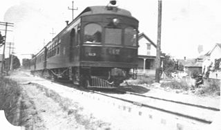
The Oregon Electric Railway (OE) was an interurban railroad line in the U.S. state of Oregon that linked Portland to Eugene. Service from Portland to Salem began in January 1908. The Spokane, Portland and Seattle Railway purchased the system in 1910, and extended service to Eugene in 1912. Regular passenger service in the Willamette Valley ended in May 1933. Freight operations continued and the railway survived into the 1990s, ultimately as a Burlington Northern feeder. Operation as an electric railroad ended July 10, 1945.

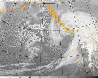
Pineapple Express is a non-technical term for a meteorological phenomenon, a specific recurring atmospheric river characterized by a strong and persistent large-scale flow of warm moist air, and the associated heavy precipitation both in the waters immediately northeast of the Hawaiian Islands and extending northeast to any location along the Pacific coast of North America. A Pineapple Express is an example of an atmospheric river, which is a more general term for such relatively narrow corridors of enhanced water vapor transport at mid-latitudes around the world.

The Willamette Stone was a small stone obelisk originally installed by the Department of Interior in 1885 in the western hills of Portland, Oregon in the United States to mark the intersection and origin of the Willamette meridian and Willamette baseline. It replaced a cedar stake placed by the Surveyor General of the Oregon Territory in 1851; this stake defined the grid system of sections and townships from which all real property in the states of Oregon and Washington has been measured following the Donation Land Claim Act of 1850. The Willamette meridian runs north–south, and the Willamette baseline runs east–west through the marker. The easternmost northeast corner of Washington County is sited on the marker.

The Columbus Day Storm of 1962 was a Pacific Northwest windstorm that struck the West Coast of Canada and the Pacific Northwest coast of the United States on October 12, 1962. Typhoon Freda was the twenty-eighth tropical depression, the twenty-third tropical storm, and the eighteenth typhoon of the 1962 Pacific typhoon season. Freda originated from a tropical disturbance over the Northwest Pacific on September 28. On October 3, the system strengthened into a tropical storm and was given the name Freda, before becoming a typhoon later that day, while moving northeastward. The storm quickly intensified, reaching its peak as a Category 3-equivalent typhoon on October 5, with maximum 1-minute sustained winds of 115 mph (185 km/h) and a minimum central pressure of 948 millibars (28.0 inHg). Freda maintained its intensity for another day, before beginning to gradually weaken, later on October 6. On October 9, Freda weakened into a tropical storm, before transitioning into an extratropical cyclone on the next day. On October 11, Freda turned eastward and accelerated across the North Pacific, before striking the Pacific Northwest on the next day. On October 13, the cyclone made landfall on Washington and Vancouver Island, and then curved northwestward. Afterward, the system moved into Canada and weakened, before being absorbed by another developing storm to the south on October 17. The Columbus Day Storm of 1962 is considered to be the benchmark of extratropical wind storms. The storm ranks among the most intense to strike the region since at least 1948, likely since the January 9, 1880 "Great Gale" and snowstorm. The storm is a contender for the title of the most powerful extratropical cyclone recorded in the U.S. in the 20th century; with respect to wind velocity, it is unmatched by the March 1993 "Storm of the Century" and the "1991 Halloween Nor'easter". The system brought strong winds to the Pacific Northwest and southwest Canada, and was linked to 46 fatalities in the northwest and Northern California resulting from heavy rains and mudslides.
Floods in the United States are generally caused by excessive rainfall, excessive snowmelt, and dam failure. Below is a list of flood events that were of significant impact to the country during the 20th century, from 1900 through 1999, inclusive.
The Hanukkah Eve windstorm of 2006 was a powerful Pacific Northwest windstorm in the Pacific Northwest region of the United States and southern British Columbia, Canada between December 14, 2006 and December 15, 2006. The storm produced hurricane-force wind gusts and heavy rainfall, causing hundreds of millions of dollars in damage and leaving over 1.8 million residences and businesses without power. Eighteen people were killed, most of whom died of carbon monoxide poisoning in the days following the storm because of improper use of barbecue cookers and generators indoors. The name of the storm was chosen in a contest run by the National Weather Service office in Seattle from about 8,000 entries.

Johnson Creek is a 25-mile (40 km) tributary of the Willamette River in the Portland metropolitan area of the U.S. state of Oregon. Part of the drainage basin of the Columbia River, its catchment consists of 54 square miles (140 km2) of mostly urban land occupied by about 180,000 people as of 2012. Passing through the cities of Gresham, Portland, and Milwaukie, the creek flows generally west from the foothills of the Cascade Range through sediments deposited by glacial floods on a substrate of basalt. Though polluted, it is free-flowing along its main stem and provides habitat for salmon and other migrating fish.

The Great Coastal Storm of 2007 was a series of three powerful Pacific storms that affected the U.S. states of Oregon and Washington and the Canadian province of British Columbia between December 1, 2007 and December 4, 2007.

Balch Creek is a 3.5-mile (5.6 km) tributary of the Willamette River in the U.S. state of Oregon. Beginning at the crest of the Tualatin Mountains, the creek flows generally east down a canyon along Northwest Cornell Road in unincorporated Multnomah County and through the Macleay Park section of Forest Park, a large municipal park in Portland. At the lower end of the park, the stream enters a pipe and remains underground until reaching the river. Danford Balch, after whom the creek is named, settled a land claim along the creek in the mid-19th century. After murdering his son-in-law, he became the first person legally hanged in Oregon.
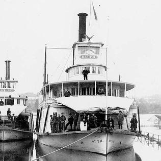
The steamboat Ruth operated from 1896 to 1917 on the Willamette River in the U.S. state of Oregon. Ruth played an important role in the transport of goods and agricultural products in Oregon, and was one of the fastest steamboats ever to operate on the upper Willamette. This vessel should not be confused with the sternwheeler Ruth built at Libby, Montana in 1896.

The Great Flood of 1862 was the largest flood in the recorded history of California, Oregon, and Nevada, inundating the western United States and portions of British Columbia and Mexico. It was preceded by weeks of continuous rains and snows that began in Oregon in November 1861 and continued into January 1862. This was followed by a record amount of rain from January 9–12, and contributed to a flood that extended from the Columbia River southward in western Oregon, and through California to San Diego, and extended as far inland as Idaho in the Washington Territory, Nevada and Utah in the Utah Territory, and Arizona in the western New Mexico Territory. The event dumped an equivalent of 10 feet (3.0 m) of water in California, in the form of rain and snow, over a period of 43 days. Immense snowfalls in the mountains of far western North America caused more flooding in Idaho, Arizona, New Mexico, as well as in Baja California and Sonora, Mexico the following spring and summer, as the snow melted.

The Christmas flood of 1964 was a major flood in the United States' Pacific Northwest and some of Northern California between December 18, 1964, and January 7, 1965, spanning the Christmas holiday. Considered a 100-year flood, it was the worst flood in recorded history on nearly every major stream and river in coastal Northern California and one of the worst to affect the Willamette River in Oregon. It also affected parts of southwest Washington, Idaho, and Nevada. In Oregon, 17 or 18 people died as a result of the disaster, and it caused hundreds of millions of dollars in damage. The flooding on the Willamette covered 152,789 acres (61,831.5 ha). The National Weather Service rated the flood as the fifth most destructive weather event in Oregon in the 20th century. California Governor Pat Brown was quoted as saying that a flood of similar proportions could "happen only once in 1,000 years," and it was often referred to later as the Thousand Year Flood. The flood killed 19 people, heavily damaged or completely devastated at least 10 towns, destroyed all or portions of more than 20 major highway and county bridges, carried away millions of board feet of lumber and logs from mill sites, devastated thousands of acres of agricultural land, killed 4,000 head of livestock, and caused $100 million in damage in Humboldt County, California, alone.

The Willamette Valley is a 150-mile (240 km) long valley in Oregon, in the Pacific Northwest region of the United States. The Willamette River flows the entire length of the valley and is surrounded by mountains on three sides: the Cascade Range to the east, the Oregon Coast Range to the west, and the Calapooya Mountains to the south.

Naito Parkway is a major thoroughfare of Portland in the U.S. state of Oregon. It was formerly known as Front Avenue and Front Street and was renamed in 1996 to honor Bill Naito. It runs between SW Barbur Boulevard and NW Front Avenue, and adjacent to Tom McCall Waterfront Park through Downtown Portland.

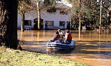
The 1948 Columbia River flood was a regional flood that occurred in the Pacific Northwest of the United States and Canada. Large portions of the Columbia River watershed were impacted, including the Portland area, Eastern Washington, northeastern Oregon, Idaho Panhandle, northwestern Montana, and southeastern British Columbia. A publication of the U.S. Geological Survey in 1949 stated property damage reached $102.7 million, 250,000 acres of farmland were flooded, 20,000 acres of land were damaged or destroyed, and at least 16 died in the flood ; estimates for total deaths from the flood go as high as 102. Among the damage was the complete destruction of Vanport, in the Portland metropolitan area, which was the second largest city in Oregon at the time. The flood was largely caused by rapid melting of above-average snowpack by heavy precipitation and warm temperatures. It remains the second largest flood recorded on the river.

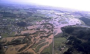
The 1996 Pacific Northwest floods were a series of floods in Washington, Oregon, and the Idaho Panhandle in the United States. Large portions of the Columbia River and Puget Sound watersheds were impacted, including the Portland, Yakima, and the Palouse region. The flood was largely caused by warm temperatures and heavy rain falling on significant snowpack and caused an estimated $800 million in damage.
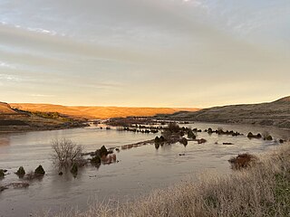
The 2020 Pacific Northwest floods were a series of floods in the Pacific Northwest, United States. The main impacts were experienced in the northwest quarter of Washington and along rivers and streams draining the Blue Mountains in southeast Washington and northeast Oregon. Small portions of the Lower Mainland in British Columbia, Canada also flooded. The flooding was primarily caused by heavy rain falling on mountain snow and represents the worst flood on record for some of the affected rivers. Large rivers in the region, such as the Columbia and Snake were largely unaffected.
The following is a timeline of the history of Oregon in the United States of America.