2019 Midwestern U.S. floods

Last updated

2019 Midwestern U.S. floods
Historic floods have inundated Nebraska (40463013783).jpg
March 2018 and March 2019 side-by-side comparison of the Omaha–Council Bluffs metropolitan area showing effects of flooding of the Platte and Missouri Rivers.
DateMarch 2019 – December 2019 [1]
Location Midwestern United States
Deaths3
Property damage$2.9 billion ($1.6 billion in Iowa; $1.3 billion in Nebraska)

The Midwestern United States experienced major floods in the spring of 2019, primarily along the Missouri River and its tributaries in Nebraska, Missouri, South Dakota, Iowa, and Kansas. The Mississippi River also saw flooding, although starting later and ending earlier. The 2019 January-to-May period was the wettest on record for the U.S., with multiple severe weather outbreaks through May in the Midwest, High Plains, and South exacerbating the flooding and causing additional damage. [2] [3] [4] Throughout late May and early June, rain in Iowa, Illinois, and Missouri caused every site on the Mississippi River to record a top-five crest. [5] At least three people in Iowa and Nebraska died. [6]

Contents

Nearly 14 million people in the midwestern and southern states were affected by the flooding, which the New York Times called "The Great Flood of 2019". [1]

New record river levels were set in 42 different locations. [7]

Although $12 billion in aid was made "available to farmers who lost money due to the trade war" the previous year, Reuters reported that the USDA had "no program to cover the catastrophic and largely uninsured stored-crop losses from the widespread flooding." [8] In Nebraska, under the banner "Nebraska Strong", private fundraisers popped up across the state to help ease the financial strain, as well as offers to donate supplies, house livestock, or donate farming supplies lost. The largest private fundraiser came from Alex Stepanek of St. Paul, Nebraska, who raised $241,756 through a Facebook fundraiser. After seeing a post he created bringing attention to the devastation across the state go viral around the world, he created the fundraiser and by the following day had over $100,000. [9] The money was distributed throughout 5 towns, 5 counties, four families who had loved ones die in the flood, and the largest chunk (1/3) went to the Nebraska Farm Bureau to go directly to agriculture and farmer needs. [9]

At least 1 million acres of U.S. farmland, in nine major grain producing states, flooded. [10]

On September 17, 2019, a third round of flooding along the Missouri River was considered likely, due to heavy rains of up to "four times what is normal in parts of Montana, North and South Dakota and Nebraska." [11]

On October 28, 2019, it was predicted that the prolonged Missouri River flooding, which lasted as long as seven months in some locations, could continue all winter, with no end in sight. [12]

On December 16, 2019, the prolonged Missouri River flooding in the Kansas City district was declared officially over. [13]

Causes

From January until early March, average temperatures in the Midwest remained in the low 20 to 30 average degree Fahrenheit range, with record snowfall in many areas, including the early March blizzard, up to three feet on the ground in some areas. [14] In Nebraska, over the course of three days (March 11 – 13), [15] temperatures rose to 60 degrees Fahrenheit, combined with 1.5 inches of rain. This quickly melted the snow, and the frozen ground was not able to absorb any meaningful amount, which led to unprecedented runoff into local streams and rivers. [16] Saturated soils, combined with elevated river flow from the previous fall, led to severe, widespread flooding across the middle of the United States. [5] Many of the rivers were still frozen over with a thick layer of ice, which the powerful flow of water broke up and dislodged, creating massive chunks of ice that traveled downstream, acting like a plow. [17]

As of September 17, 2019, a third round of flooding along the Missouri River was considered likely, due to heavy rains of up to "four times what is normal in parts of Montana, North and South Dakota and Nebraska." [11]

Damage

Illinois

Illinois was affected by the flooding, and the Illinois National Guard was activated to assist with the efforts along the Illinois and Mississippi Rivers. [18] [19] The Illinois National Guard was released from flood fighting duties on July 29, 2019. [20]

The river crest in Grafton was the fourth highest ever recorded. Cairo experienced over 156 days with waters above flood stage. [1]

In March, record flooding occurred on segments of the Rock and Pecatonica Rivers, and minor to moderate flooding occurred on the Fox, Des Plaines, Kankakee and Illinois Rivers. [21] The Pecatonica River, which has flooded seven times since May 2017, flooded again in October, along with other Chicago area rivers including the Fox River and the Rock River. [22] [23] Freeport is seeking funding to buy out flood-prone homes. [22]

Iowa

Iowa was also affected by heavy rains and flooding. Iowa Governor Kim Reynolds signed an emergency disaster proclamation March 14. [24] One man was killed in Iowa. [25]

Parts of all nine state parks were closed. [24] Standing water from the spring floods was still present near Iowa roads in mid-September. [26] [27]

Governor Reynolds estimated the damage at $1.6 billion, a state record. Reynolds asked the president to declare a disaster in 67 counties. [28] [29]

A website was established, 2019 Iowa Floods, to help residents apply for assistance, report hazards, check on levee and road status, and access areas with closed roads.

Western Iowa

Western Iowa suffered severe impacts, especially in the Missouri River Valley south of Council Bluffs. There, at least 30 levee failures flooded towns and highways. [30]

In Hamburg, two-thirds of the town was underwater when the bomb cyclone hit. [31] The town lost sewage and gas services, according to city officials. [32] The town's levee, which was in need of repair, was breached. Residents had been unable to raise the $5 million for necessary repairs before the storm, despite releasing a 2012 flash mob YouTube video of residents dancing on Main Street, singing "Levee. Levee. Save us from the river." to the tune of Creedence Clearwater Revival's "Proud Mary." [1] [33]

Floodwaters damaged the water treatment plant in Glenwood. [34] On April 5, the city of Glenwood was still "trucking in more than 6,000-gallon tanks of water to provide the roughly 275,000 gallons its residents ... [were] using each day." [35]

On April 11, hundreds of homes in Fremont County were still evacuated, and road closures remained in place. [36] Satellite images from the Weather Channel showed the town of Bartlett almost completely underwater. [37] Fremont County farmers lost an estimated "390,000 bushels of stored soybeans and about 1.2 million bushels of stored corn." [38]

One homeowner in McPaul had to wait 180 days for floodwater to drain; the home flooded again five days later. The McPaul exit off of Interstate 29 was still closed in early October, and standing water was visible. [33]

43% of flooded homeowners in Pacific Junction, other parts of rural Mills County, and Hamburg expressed interest in federal buyouts, which have a partial funding match from the Iowa Flood Mitigation Board. [33]

Eastern Iowa

In Eastern Iowa, the Quad Cities spent 96 days with the Mississippi above flood stage levels. In Burlington, the Mississippi rose above its banks for more than 104 days, surpassing its 1993 record. [39]

The Mississippi River Cities and Towns Initiative (MRCTI) estimated over 2 billion dollars in flood damage. [39]

Road closures

Interstate 29 was closed in March, and again in May, from Council Bluffs to the Missouri state border and from there to St. Joseph, Missouri, [40] [41] [42] with portions of the interstate under 15 ft (4.6 m) of water.[ citation needed ]

On September 20, sections of Interstate-680 and Interstate 29 were once again closed due to Missouri River flooding. Some of the standing water by Iowa roads had been there since the spring floods. [26] [27]

Missouri

Picture taken in Rocheport, Missouri, during the flood of 2019. Flood of 2019- Rocheport, MO.jpg
Picture taken in Rocheport, Missouri, during the flood of 2019.

The entire community of Craig, as well as parts of St. Joseph, were evacuated, [43] and portions of Interstate 29 were under 15 feet (4.6 metres) of water. On March 21, a state of emergency was issued by Governor Mike Parson, who said:

The rising floodwaters are affecting more Missouri communities and farms, closing more roads and threatening levees, water treatment plants and other critical infrastructure. We will continue to work closely with our local partners to assess needs and provide resources to help as Missourians continue this flood fight and as we work to assist one another. [44]

In Holt County, about 30,000 acres (12,140 hectares) of the 95,000 acres (38,445 hectares) that flooded in spring 2019 were still underwater in late October, leading to concerns of the floodwater freezing during the winter. [12] Corning had flooded more than once by November. [45]

Nebraska

Aerial view of Offutt Air Force Base in Nebraska, flooded Team Offutt battling flood waters 190317-F-IT794-1052.jpg
Aerial view of Offutt Air Force Base in Nebraska, flooded

On March 14, 2019, the Spencer Dam on the Niobrara River collapsed, releasing an eleven-foot wall of water. [46] The unrestrained flooding which followed destroyed three bridges downstream, including the Highway 281 bridge. [47] [37]

In east central Nebraska, residents along the flooded Missouri, Platte and Elkhorn Rivers were forced to evacuate as some locals experienced all-time record flooding. The city of Norfolk evacuated a third of its residents. [48] The Platte and Elkhorn Rivers had overflowed their levees in the greater Omaha region, and some communities were put under a mandatory evacuation order. The Platte River at numerous sites had reached flooding of "historical proportions" with some sites breaking all-time record flood levels by as much as 5 feet (1.5 m). [49] By March 15, access to the city of Fremont was blocked due to all roads being closed in and out of the city. [50] This remained the case days later, with national guard military convoys being set up to get food and other supplies into the city.

Offutt Air Force Base had extensive flooding from the Missouri River, inundating 30 buildings and 3,000 ft (910 m) of their only runway. [51] The base received damage that was said to "not be repaired for months", which caused some events to be moved back. [52] Camp Ashland, one of the Nebraska National Guard's main training sites, was also extensively damaged, with 51 of 62 buildings affected. Military representatives stated that the flooding is the worst that the camp has seen in its history, including a serious flood from 2015 that cost 3.7 million in repairs. It took several months to clean and repair the facility to support scaled back operations, with more extensive rebuilding efforts ongoing for the next several years. [53]

Thirty of the one hundred homes in Lynch were destroyed by the flood. [1]

On March 18, Nebraska governor Pete Ricketts declared a state of emergency and stated that the floods caused "[t]he most extensive damage our state has ever experienced." [54]

Flood damage in Nebraska has been estimated at over $1.3 billion, including "$449 million in damage to roads, levees and other infrastructure." Twenty-seven bridges were damaged. [55]

Agricultural damages included "$440 million in crop losses; and $400 million in cattle losses." [56] [57] Livestock losses included seven hundred hogs that were drowned on a farm near Fremont. [58] Volunteers from Ohio's Rural America Relief mounted a 10 truck convoy to North Bend with supplies for farm cleanup, "including four Gators to access the saturated fields." [59] After the 2011 Missouri River Flood, "it took years for some affected fields to be cleaned of debris and sand," according to a Nebraska DOT official." [57] Nebraska's agronomists stress the importance of choosing appropriate cover crops for flooded fields which can not be replanted. [60] [61] [57]

The University of Nebraska announced Flood Recovery Serviceships with the Nebraska Disaster Recovery Service Corps, sending 24 students to affected communities. [62] [63]

North Dakota

Widespread spring flooding "damaged homes, public infrastructure, hundreds of roads and thousands of acres of farmland in 19 counties in western, south central and eastern North Dakota," and resulted in $16.6 million in federal funds and state loans. [64]

On October 21, 2019, North Dakota Governor Doug Burgum declared a statewide flood emergency, as "unprecedented fall flooding" and rising river levels threatened the harvest. [65] North Dakota Agricultural Commissioner Doug Goehring said, "We probably have in western Minnesota and North Dakota about two billion dollars worth of soybeans that are sitting in water or at least in conditions which may not allow producers to get out there and get them anytime soon." [66]

South Dakota

In March 2019, a powerful blizzard dumped up to two feet of snow in South Dakota, followed by rapidly warming temperatures that left flooding in its wake. [67] Some residents of the Pine Ridge Indian Reservation were stranded for days, and about 8,000 people lost drinking water. [68] High water on the Moreau River prompted evacuations on the Cheyenne River Indian Reservation. [69] Pennington County approved a local disaster declaration as a result of a bridge collapse and other damage. [67]

In September 2019, "heavy rains dumped more than four times what is normal in parts of Montana, North and South Dakota and Nebraska." [70] [71]

Between September 12–15, 2019, the Big Sioux River overflowed its banks. Three blocks of Dell Rapids, South Dakota were flooded, and up to a dozen homes damaged. [72] Bridges were washed out in Mitchell, which received 7 inches of rain in one night. [73] [74] Interstate 90 was shut down between Mitchell and Sioux Falls. [75] [76] Baltic, South Dakota, was only accessible via Highway 115. [74] Non-residents were urged to avoid Dell Rapids, Baltic, and Renner until the floods cleared. [77] In Madison, "about 30 people had to be rescued by boats and heavy equipment," after nine inches of rain fell in just two days. [73] Schools in Spencer were closed for two days, and streets were submerged. [70]

On September 17, residents of Dakota Dunes, a development sandwiched between the Big Sioux River and the Missouri River, were encouraged to evacuate as a precaution due to heavy rains, with peak waters expected the following Tuesday." [11]

See also

Related Research Articles

<span class="mw-page-title-main">Interstate 29</span> Interstate Highway from Kansas City north to Canada

Interstate 29 (I-29) is an Interstate Highway in the Midwestern United States. I-29 runs from Kansas City, Missouri, at a junction with I-35 and I-70, to the Canada–US border near Pembina, North Dakota, where it connects with Manitoba Provincial Trunk Highway 75 (PTH 75), which continues on to Winnipeg. The road follows the course of three major rivers, all of which form the borders of US states. The southern portion of I-29 closely parallels the Missouri River from Kansas City northward to Sioux City, Iowa, where it crosses and then parallels the Big Sioux River. For the northern third of the highway, it closely follows the Red River of the North. The major cities that I-29 connects to includes Council Bluffs, Iowa; Sioux City, Iowa; Sioux Falls, South Dakota; Fargo, North Dakota; and Grand Forks, North Dakota.

<span class="mw-page-title-main">Hamburg, Iowa</span> City in Iowa, United States

Hamburg is a city in Fremont County, Iowa, United States, that is the most southwestern city in Iowa, hugging the borders of Missouri to the south and Nebraska to the west. It is situated between the Nishnabotna and Missouri rivers. The population was 890 at the time of the 2020 census. It derives its name from the German city of Hamburg.

<span class="mw-page-title-main">Big Sioux River</span> River in eastern South Dakota and northwestern Iowa

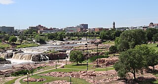
The Big Sioux River is a tributary of the Missouri River in eastern South Dakota and northwestern Iowa in the United States. It flows generally southwardly for 419 mi (674 km), and its watershed is 9,006 sq mi (23,330 km2). The United States Board on Geographic Names settled on "Big Sioux River" as the stream's name in 1931. The river was named after the Lakota people which was known by them as Tehankasandata, or Thick Wooded River.

<span class="mw-page-title-main">Great Flood of 1993</span> Midwestern United States flooding

The Great Flood of 1993 was a flood that occurred in the Midwestern United States, along the Mississippi and Missouri rivers and their tributaries, from April to October 1993.

<span class="mw-page-title-main">Eppley Airfield</span> Airport in Omaha, Nebraska, United States

Eppley Airfield, also known as Omaha Airport, is an airport in the midwestern United States, located three miles (5 km) northeast of downtown Omaha, Nebraska. On the west bank of the Missouri River in Douglas County, it is the largest airport in Nebraska, with more arrivals and departures than all other airports in the state combined. It is classified as a medium hub airport by the Federal Aviation Administration (FAA). It is owned and operated by the Omaha Airport Authority (OAA).

<span class="mw-page-title-main">Interstate 680 (Nebraska–Iowa)</span> Highway in Iowa and Nebraska

Interstate 680 (I-680) in Nebraska and Iowa is the northern bypass of the Omaha–Council Bluffs metropolitan area. I-680 spans 16.49 miles (26.54 km) from its southern end in western Omaha, Nebraska, to its eastern end near Crescent, Iowa. The freeway passes through a diverse range of scenes and terrains—the urban setting of Omaha, the Missouri River and its valley, the rugged Loess Hills, and the farmland of Pottawattamie County, Iowa.

East Omaha is a geographically designated community located in Omaha, Nebraska. Located three miles (5 km) from downtown Omaha, East Omaha is the site of Eppley Omaha International Airport, Omaha's main airport, and Carter Lake. This area was Omaha's first annexation, joining the city in 1854. Originally separated from Omaha by the Missouri River, a large section of the area's land was dissected by a ruling from the U.S. Supreme Court in 1892. Today, 2,500 houses, a school, grocery stores and a church that made up the original town have been demolished and replaced by several government facilities, the Eppley Airfield, and more.

<span class="mw-page-title-main">Floods in the United States (2000–present)</span>

Floods in the United States (2000–present) is a list of flood events which were of significant impact to the country during the 21st century, since 2000. Floods are generally caused by excessive rainfall, excessive snowmelt, storm surge from hurricanes, and dam failure.

<span class="mw-page-title-main">Early Spring 2008 Midwest floods</span> Weather event

The March 2008 Midwest floods were a massive flooding event in the Southern Midwest and portions of the Southern Plains. Cape Girardeau, Missouri officially reported 11.48 inches (29.2 cm) between March 18 and 19. At least 17 people died as a result of the flooding. Levee breaks were observed in several areas, most notably in Southeastern Missouri, where levee breaks occurred through mid-April.

The Great Flood of 1881 was along the Missouri River between April 1, 1881, and April 27, 1881. The flood began around Pierre, South Dakota and struck areas down river in Yankton, South Dakota, Omaha, Nebraska, Council Bluffs, Iowa, Nebraska City, Nebraska, Kansas City, Missouri, and farther south. This was the first detailed reporting of Missouri River flooding, and caused millions of dollars in damage.

<span class="mw-page-title-main">Tornado outbreak sequence of June 3–11, 2008</span> 2008 tornado outbreak in the United States

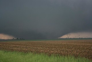
The tornado outbreak sequence of June 3–11, 2008 was a series of tornado outbreaks affecting most of central and eastern North America from June 3–11, 2008. 192 tornadoes were confirmed, along with widespread straight–line wind wind damage. Seven people were killed from a direct result of tornadoes; four in Iowa, two in Kansas, and one in Indiana. Eleven additional people were killed across five states by other weather events including lightning, flash flooding, and straight-line winds. Severe flooding was also reported in much of Indiana, Wisconsin, Minnesota and Iowa as a result of the same thunderstorms, while high heat and humidity affected much of eastern North America; particularly along the eastern seaboard of the United States from New York City to the Carolinas.

<span class="mw-page-title-main">June 2008 Midwest floods</span> Weather outbreak that lead to flooding in the American Midwest

The June 2008 Midwestern United States floods were flooding events which affected portions of the Midwestern United States. After months of heavy precipitation, a number of rivers overflowed their banks for several weeks at a time and broke through levees at numerous locations. Flooding continued into July. States affected by the flooding included Illinois, Indiana, Iowa, Michigan, Minnesota, Missouri and Wisconsin. The American Red Cross assisted the victims of flooding and tornadoes across seven states and the National Guard was mobilized to assist in disaster relief and evacuation.

<span class="mw-page-title-main">Iowa flood of 2008</span> Natural Disaster (flood) in Iowa, US from June 8 – July 1, 2008

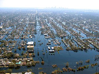
The Iowa flood of 2008 was a hydrological event involving most of the rivers in eastern Iowa which began June 8 and continued until July 1. Flooding continued on the Upper Mississippi River in the southeastern area of the state for many more days. The phrase "Iowa's Katrina" was often heard.

<span class="mw-page-title-main">2011 Missouri River Flood</span> 2011 flood affecting multiple states in USA

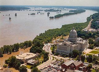
The 2011 flooding event on the Missouri River in the United States was triggered by record snowfall in Rocky Mountains of Montana and Wyoming along with near-record spring rainfall in central and eastern Montana. All six major dams along the Missouri River released record amounts of water to prevent overflow which led to flooding threatening several towns and cities along the river from Montana to Missouri; in particular Bismarck, North Dakota; Pierre, South Dakota; Dakota Dunes, South Dakota; South Sioux City, Nebraska, Sioux City, Iowa; Omaha, Nebraska; Council Bluffs, Iowa; Saint Joseph, Missouri; Kansas City, Missouri; Jefferson City, Missouri, and St. Louis, Missouri. Many smaller towns were also at risk, suffering the same fate as the larger cities if not worse. According to the National Weather Service, in the second half of the month of May 2011, almost a year's worth of rain fell over the upper Missouri River basin. Extremely heavy rainfall in conjunction with an estimated 212 percent of normal snowpack in the Rocky Mountains contributed to this flooding event.

<span class="mw-page-title-main">2011 Souris River flood</span> 2011 flood affecting Canada and USA

The 2011 Souris/Mouse River flood in Canada and the United States occurred in June and was greater than a hundred-year flooding event for the river. The US Army Corps of Engineers estimated the flood to have a recurrence interval of two to five centuries.

<span class="mw-page-title-main">Great Flood of 1913</span> Natural disaster affecting the southern and eastern United States

The Great Flood of 1913 occurred between March 23 and March 26, after major rivers in the central and eastern United States flooded from runoff and several days of heavy rain. Related deaths and damage in the United States were widespread and extensive. While the exact number is not certain, flood-related deaths in Ohio, Indiana, and eleven other states are estimated at approximately 650. The official death toll range for Ohio falls between 422 and 470. Flood-related death estimates in Indiana range from 100 to 200. More than a quarter million people were left homeless. The death toll from the flood of 1913 places it second to the Johnstown Flood of 1889 as one of the deadliest floods in the United States. The flood remains Ohio's largest weather disaster. In the Midwestern United States, damage estimates exceeded a third of a billion dollars. Damage from the Great Dayton Flood at Dayton, Ohio, exceeded $73 million. Indiana's damages were estimated at $25 million. Further south, along the Mississippi River, damages exceeded $200 million. Devastation from the flood of 1913 and later floods along the Mississippi River eventually changed the country's management of its waterways and increased federal support for comprehensive flood prevention and funding for flood control projects. The Ohio Conservancy Act, which was signed by the governor of Ohio in 1914, became a model for other states to follow. The act allowed for the establishment of conservancy districts with the authority to implement flood control projects.

<span class="mw-page-title-main">March 2019 North American blizzard</span> Colorado Low storm

The March 2019 North American blizzard was a powerful Colorado Low that produced up to two feet of snow in the plains and Midwest. Rapid snowmelt following the storm caused historic flooding, and some areas received hurricane-force wind gusts. Comparable to the 1993 Storm of the Century, the storm was labeled a bomb cyclone after barometric pressure readings dropped in excess of 24 mbar (0.71 inHg) over a 24-hour period. After the storm entered Colorado from its origination in Arizona, the pressure dropped more than 30 mbar (0.89 inHg) and rapidly intensified over the western High Plains. The severe storm set new all-time record low barometric pressure readings in Colorado, Kansas and New Mexico. The storm itself killed only one person in Colorado, but flooding caused by the storm killed at least 3, one in Iowa and at least two in Nebraska and left ~140,000 without power in Texas.

<span class="mw-page-title-main">2019 Arkansas River floods</span> A series of floods effecting the Arkansas river basin in 2019

Between May and June 2019, an extended sequence of heavy rainfall events over the South Central United States caused historic flooding along the Arkansas River and its tributaries. Major and record river flooding occurred primarily in northeastern Oklahoma, and the elevated flows continued downstream into Arkansas where they caused additional inundation. Antecedent soil moisture levels and water levels in lakes and streams were already high from previous rains, priming the region for significant runoff and flooding. The prolonged combination of high atmospheric moisture and a sustained weather pattern extending across the continental United States led to frequent high-yield rainfall over the Arkansas River watershed. The overarching weather pattern allowed moisture levels to quickly rebound after each sequential rainfall episode. With soils already saturated, the excess precipitation became surface runoff and flowed into the already elevated lakes and streams. Most rainfall occurred in connection with a series of repeated thunderstorms between May 19–21, which was then followed by additional rains that kept streams within flood stage.

The 2022 south eastern Australia floods are a series of floods that have occurred in south-eastern Australia since October 2022. Some towns experienced the highest river peaks in decades, and many places saw rivers peak multiple times. The floods were attributed to excess torrential rain caused by La Niña and a negative Indian Ocean Dipole.

<span class="mw-page-title-main">2013 Midwestern U.S. floods</span>

In April 2013, persistent heavy rains caused widespread flooding, primarily impacting the Midwestern and Great Lakes regions. In a span of two days on April 17 and 18, heavy rainfall associated with a slow-moving storm system caused widespread flooding across rivers and areas, where rainfall amounts over 8 inches (200 mm) caused rivers to swell and crest, including the Mississippi River and the Red River, with the latter river dealing with melting ice caps. The Grand River crested to a record level, prompting water rescues and evacuations in Grand Rapids, Michigan. A local state of emergency was declared for the city of Des Plaines, Illinois after the Des Plaines River swelled to 10.92 feet (3,330 mm). The governors of Illinois and Missouri declared state of emergencies, and the Federal Emergency Management Agency declared a federal emergency and a disaster declaration for 46 counties in Illinois. Five fatalities occurred: two each in Illinois and Indiana, with a fifth in Missouri. Three others were injured, all in Illinois.

References

  1. 1 2 3 4 5 Almukhtar, Sarah; Migliozzi, Blacki; Schwartz, John; Williams, Josh (September 11, 2019). "The Great Flood of 2019: A Complete Picture of a Slow-Motion Disaster". New York Times . Archived from the original on September 12, 2019. Retrieved September 15, 2019.
  2. "Severe Won't Let Up: Major Outbreak and Flood Threat Looming for Monday by Bob Henson | Category 6". Weather Underground. Retrieved July 5, 2019.
  3. "Classic Spring Severe Weather Outbreak on Tap for Southern Plains by Bob Henson | Category 6". Weather Underground. Retrieved July 5, 2019.
  4. "Wettest 12 Months in U.S. History—Again by Bob Henson | Category 6". Weather Underground. Retrieved July 5, 2019.
  5. 1 2 US Department of Commerce, NOAA. "Spring Flooding Summary 2019". www.weather.gov. Retrieved July 8, 2019.
  6. Smith, Mitch (March 20, 2019). "An Iowa Town Fought and Failed to Save a Levee. Then Came the Flood". The New York Times . Retrieved March 21, 2019.
  7. Erdman, Jonathan (March 17, 2019). "Record Flooding in Nebraska, Iowa, South Dakota, Wisconsin, Minnesota and Illinois Follows Snowmelt, Bomb Cyclone". The Weather Channel, via Climate Signals. Retrieved September 22, 2019.
  8. Polansek, Tom (April 2, 2019). "U.S. disaster aid won't cover crops drowned by Midwest floods". Reuters, via Climate Signals. Archived from the original on September 21, 2019. Retrieved September 21, 2019.
  9. 1 2 Service, Betsie Freeman BH Media News. "An astonishing fundraiser". The Grand Island Independent. Retrieved September 27, 2021.
  10. Huffstutter, P.J.; Pamuk, Humeyra (April 1, 2019). "Exclusive: More than 1 million acres of U.S. cropland ravaged by floods". Reuters, via Climate Signals. Archived from the original on September 22, 2019. Retrieved September 22, 2019.
  11. 1 2 3 Associated Press (September 17, 2019). "Third round of flooding in 2019 likely along Missouri River". KOMU.com. Archived from the original on September 20, 2019. Retrieved September 22, 2019.
  12. 1 2 Associated Press (October 28, 2019). "Prolonged Missouri River flooding could last all winter". KSDK. Retrieved November 13, 2019.
  13. "Missouri River flood in Kansas City district officially over". KSHB. December 16, 2019. Retrieved December 17, 2019.
  14. Hassan, Adeel (March 18, 2019). "Why Is There Flooding in Nebraska, South Dakota, Iowa and Wisconsin?". The New York Times.
  15. "Omaha Month Weather - AccuWeather Forecast for NE 68102". AccuWeather.
  16. Hassan, Adeel (March 18, 2019). "Why Is There Flooding in Nebraska, South Dakota, Iowa and Wisconsin?". The New York Times. Retrieved March 21, 2019.
  17. Bureau, Paul Hammel World-Herald. "Propelled by ferocious floodwaters, huge ice chunks batter buildings in Niobrara". Omaha.com.
  18. "Pritzker Activates Illinois National Guard Amid Flooding". NBC Chicago.
  19. "National Guard arrives in Southern Illinois to help with flood preparation efforts". bnd.
  20. Parker, Molly (August 1, 2019). "Illinois National Guard Released from Flood-Fighting Duties". www.govtech.com.
  21. Dailey, Paul (March 18, 2019). "Record flooding on segments of the Rock and Pecatonica Rivers". WGN-TV. Archived from the original on March 19, 2019. Retrieved November 13, 2019.
  22. 1 2 Chase, Brett (November 11, 2019). "Neighborhoods Face Extinction As Floods Increase". Better Government Association. Archived from the original on November 11, 2019. Retrieved November 13, 2019.
  23. Dailey, Paul (October 18, 2019). "Chicago-area rivers are falling – flooding continues on segments of the Rock, Fox and Pecatonica Rivers". WGN-TV. Archived from the original on October 19, 2019. Retrieved November 13, 2019.
  24. 1 2 "Late-winter storm hits Midwest after paralyzing Colorado". Twin Cities. March 14, 2019. Retrieved March 16, 2019.
  25. Johnson, Alex. "Historic flooding kills three, forces hundreds from homes across the Midwest". NBC News. No. March 17, 2019. Retrieved March 18, 2019.
  26. 1 2 Campbell, Tara. "HEARTLAND FLOOD: A half a year deep in the water". www.wowt.com. Retrieved September 22, 2019.
  27. 1 2 Peikes, Katie (September 20, 2019). "Missouri River Flooding Closes Portions Of I-680, I-29". www.iowapublicradio.org. Retrieved September 22, 2019.
  28. "Flood Damage costs 1.6 billion in Iowa". Associated Press. March 22, 2019. Retrieved March 22, 2019.
  29. "Flooding causes estimated $1.6B damage in Iowa". KCCI. March 22, 2019.
  30. Norvell, Kim (March 20, 2019). "Number of levee breaches up to 30 from 12, and Iowa's flood season is just getting started". Des Moines Register. Retrieved September 21, 2019.
  31. Young, Robin; McMahon, Serena (April 10, 2019). "'Half Of Our Town Is Still Underwater': One Iowa Mayor Worries About More Flooding As Snow Hits The Midwest". WBUR . Archived from the original on April 10, 2019. Retrieved September 21, 2019.
  32. Everson, Sean (March 19, 2019). "Hamburg, Iowa, devastated by flooding, is without water, sewage and gas". KETV Omaha. ABC. Retrieved March 22, 2019.
  33. 1 2 3 Norvell, Kim (October 9, 2019). "205 days and counting: For western Iowa, recovery from historic flooding remains a long way off". Des Moines Register. Retrieved December 8, 2019.
  34. Peikes, Katie (March 19, 2019). "Floodwaters Affect Southwest Iowa Water Plants". Iowa Public Radio . Archived from the original on March 20, 2019. Retrieved September 22, 2019.
  35. Funk, Josh (April 5, 2019). "Climate Signals | In southwest Iowa and elsewhere, drinking water problems linger long after flooding". Des Moines Register, via Climate Signals. Archived from the original on September 21, 2019. Retrieved September 21, 2019.
  36. Peikes, Katie (April 12, 2019). "Fremont County Family Among Many Devastated By Western Iowa Flooding". www.iowapublicradio.org. Retrieved September 22, 2019.
  37. 1 2 Dolce, Chris (March 19, 2019). "Before-and-After Images Show Ongoing Flood Disaster in Nebraska and Iowa". The Weather Channel. Archived from the original on March 17, 2019. Retrieved September 22, 2019.
  38. Eller, Donnelle (March 19, 2019). "Western Iowa farmers rush to save grain, livestock before Missouri flood waters overtake them". Des Moines Register. Retrieved September 22, 2019.
  39. 1 2 Gerlock, Grant (June 25, 2019). "As Water Recedes, River Cities Tally Flood Damage". Iowa Public Radio . Archived from the original on June 26, 2019. Retrieved September 22, 2019.
  40. Norvell, Kim (March 20, 2019). "Number of levee breaches up to 30 from 12, and Iowa's flood season is just getting started". Des Moines register. Retrieved March 21, 2019.
  41. Norvell, Kim (May 29, 2019). "Interstate 29 is closed — again — due to flooding in Iowa, Missouri". Des Moines Register. Retrieved September 22, 2019.
  42. Gaarder, Nancy (March 15, 2019). "Portions of Interstate 29 closed; Highway 2 closed at Nebraska City Missouri River bridge". Sandhills Express. Archived from the original on September 22, 2019. Retrieved September 22, 2019.
  43. "People in Craig, Missouri, told to 'evacuate town immediately' after levee breach". KNBC Kansas City. March 20, 2019. Retrieved March 22, 2019.
  44. Hollingsworth, Heather. "Missouri declares state of emergency amid flooding; Nebraska estimates over $1 billion in damage". Associated Press. Chicago Tribune. Retrieved March 23, 2019.
  45. Banerjee, Neela (November 25, 2019). "The Common Language of Loss". InsideClimate News . Archived from the original on November 27, 2019. Retrieved December 8, 2019.
  46. Salter, Peter (March 17, 2019). "11-foot wall of water: One dam breaks, three counties suffer". JournalStar.com. Archived from the original on March 17, 2019. Retrieved September 22, 2019.
  47. "Spencer Dam collapsed". Siouxland Proud. March 14, 2019. Archived from the original on March 27, 2019. Retrieved March 15, 2019.
  48. "Flash flood emergency up for Platte after ice jam breaks; 1 missing in Norfolk". Lincoln Journal Star. March 14, 2019. Retrieved March 15, 2019.
  49. Duffy, Erin; Gaarder, Nancy; Peters, Chris (March 15, 2019). "Flood emergency declared for western Douglas County; weather service urges residents to evacuate". Omaha World-Herald. Retrieved March 15, 2019.
  50. Ursch, Blake. "Access to Fremont blocked due to road closures caused by record flooding". Omaha.com.
  51. Liewer, Steve. "One-third of Offutt underwater; at least 30 buildings damaged in flood". Omaha World-Herald. Retrieved March 18, 2019.
  52. Ortega, Jennifer. "HEARTLAND FLOOD: Offutt begins long road to recovery from flood". www.wowt.com.
  53. "Nebraska National Guard camp recovering after worst flooding of the last century, official says". Stars and Stripes. Archived from the original on April 7, 2019. Retrieved April 7, 2019.
  54. Ristau, Reece (March 19, 2019). "Floodwaters receding in Nebraska, but long and costly recovery lies ahead". Winston-Salem Journal . Retrieved March 19, 2019 via Omaha World-Herald.
  55. Mollenkamp, Allison (July 2, 2019). "Nebraska Roads and Bridges Still in Recovery After Flooding | netnebraska.org". NET Nebraska News. Archived from the original on July 2, 2019. Retrieved September 22, 2019.
  56. Schwartz, Matthew S (March 21, 2019). "Nebraska Faces Over $1.3 Billion In Flood Losses". National Public Radio . Retrieved September 22, 2019.
  57. 1 2 3 Spiegel, Bill (March 20, 2019). "Nebraska Flood Damage: $1.5 Billion and Rising". Successful Farming. Archived from the original on August 6, 2019. Retrieved September 22, 2019.
  58. Chapman, John (March 19, 2019). "Fremont farmers lose hundreds of animals in flood". WOWT . Archived from the original on March 31, 2019. Retrieved September 22, 2019.
  59. Tevis, Cheryl (August 19, 2019). "Ohio Volunteers Help Flooded Farmers in Nebraska". Successful Farming. Archived from the original on August 19, 2019. Retrieved September 22, 2019.
  60. Sivits, Sarah (July 12, 2019). "Crop Impacts and Options After Mid-Season Flooding". CropWatch. Archived from the original on September 22, 2019. Retrieved September 22, 2019.
  61. Pope, Joanna (August 26, 2019). "Noah's Nebraska Flood Story". Farmers.gov. Archived from the original on September 22, 2019. Retrieved September 22, 2019.
  62. "Flood Recovery Serviceships". University of Nebraska. 2019. Archived from the original on April 11, 2019. Retrieved September 22, 2019.
  63. "Nebraska students begin flood serviceship projects". University of Nebraska. June 27, 2019. Archived from the original on July 10, 2019. Retrieved September 22, 2019.
  64. "North Dakota to use $16.6M to cover spring flooding costs". The Mighty 790 KFGO. September 19, 2019. Archived from the original on October 25, 2019. Retrieved October 25, 2019.
  65. "Burgum declares statewide flood emergency". KX NEWS. October 21, 2019. Retrieved October 25, 2019.
  66. "North Dakota governor declares a statewide flood emergency". MPR News. Retrieved October 25, 2019.
  67. 1 2 DenOuden, Candy (April 9, 2019). "Pennington County approves local disaster declaration". Rapid City Journal Media Group. Archived from the original on April 11, 2019. Retrieved September 21, 2019.
  68. Smith, Mitch (March 24, 2019). "'A State of Emergency': Native Americans Stranded for Days by Flooding". The New York Times. ISSN   0362-4331 . Retrieved September 21, 2019.
  69. "Flooding forces evacuations on South Dakota reservation". KX NEWS. March 28, 2019. Retrieved September 21, 2019.
  70. 1 2 Funk, Josh. "Third round of flooding in 2019 likely along Missouri River". Associated Press, via www.msn.com. Archived from the original on September 20, 2019. Retrieved September 22, 2019.
  71. "Missouri River Basin – Update" (PDF). US Army Corps of Engineers. September 17, 2019. Archived from the original (PDF) on September 22, 2019.
  72. Sneve, Joe (September 20, 2019). "Homes in Dell Rapids could be slated for demolition after floods". Argus Leader. Retrieved September 21, 2019.
  73. 1 2 "Homes Evacuated, Roads Washed Out in South Dakota Flooding". The Weather Channel. September 14, 2019. Archived from the original on September 15, 2019. Retrieved September 21, 2019.
  74. 1 2 "Mitchell among many communities hit by flooding". KSFY . September 12, 2019. Archived from the original on September 13, 2019. Retrieved September 21, 2019.
  75. Nelson, Katie; Sneve, Joe; Ferguson, Danielle; Huber, Makenzie (September 12, 2019). "Big Sioux River surpasses March's record-breaking flood levels, I-90 closed from Plankinton to Sioux Falls". Argus Leader. Retrieved September 21, 2019.
  76. "UPDATE: Portions of I-90 to remain closed". KSFY . September 12, 2019. Archived from the original on September 13, 2019. Retrieved September 21, 2019.
  77. Hergert, Kristin (March 25, 2019). "Please stay away if you're not from the area". KELO Newstalk 1320 107.9. Archived from the original on September 21, 2019. Retrieved September 21, 2019.