Eastern Ontario is a secondary region of Southern Ontario in the Canadian province of Ontario which lies in a wedge-shaped area between the Ottawa River and St. Lawrence River. It shares water boundaries with Quebec to the north and New York State to the east and south, as well as a small land boundary with the Vaudreuil-Soulanges region of Quebec to the east.

The North American Ice Storm of 1998 was a massive combination of five smaller successive ice storms in January 1998 that struck a relatively narrow swath of land from eastern Ontario to southern Quebec, New Brunswick and Nova Scotia in Canada, and bordering areas from northern New York to central Maine in the United States. It caused massive damage to trees and electrical infrastructure throughout the area, leading to widespread long-term power outages. Millions were left in the dark for periods varying from days to several weeks, and in some instances, months. It led to 34 fatalities, a shutdown of activities in large cities like Montreal and Ottawa, and an unprecedented effort in reconstruction of the power grid. The ice storm led to the largest deployment of Canadian military personnel since the Korean War, with over 16,000 Canadian Forces personnel deployed, 12,000 in Quebec and 4,000 in Ontario at the height of the crisis.

HMCS Ville de Québec is a Halifax-class frigate that has served in the Canadian Forces and Royal Canadian Navy since 1993. Ville de Québec is the third vessel in her class which is the name for the Canadian Patrol Frigate Project. The frigate is the second Royal Canadian Navy ship to be named Ville de Québec and is Canada's only fully bilingual warship. She is assigned to Maritime Forces Atlantic (MARLANT) and is homeported at CFB Halifax. The vessel serves on MARLANT missions protecting Canada's sovereignty in the Atlantic Ocean and enforcing Canadian laws in its territorial sea and exclusive economic zone.

The Cameron Highlanders of Ottawa (Duke of Edinburgh's Own) is a Canadian Army Primary Reserve infantry regiment.

Canada was one of the countries to provide the most aid and relief for Hurricane Katrina. They provided ships, supplies, volunteers, search-and-rescue teams, and more. It has also accepted some evacuees to stay in Canada.
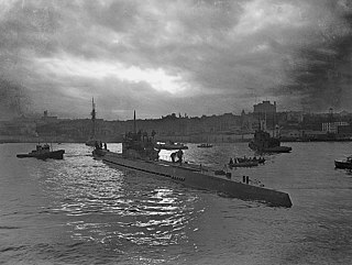
The Battle of the St. Lawrence involved marine and anti-submarine actions throughout the lower St. Lawrence River and the entire Gulf of Saint Lawrence, Strait of Belle Isle, Anticosti Island and Cabot Strait from May–October 1942, September 1943, and again in October–November 1944. During this time, German U-boats sank over 20 merchant ships and four Canadian warships. There were several near-shore actions involving the drop of German spies, or the attempted pickup of escaping prisoners of war. Despite the 23 ships lost, this battle marked a strategic victory for Canadian forces as ultimately they managed to disrupt U-boat activity, protect Canadian and Allied convoys, and intercept all attempted shore operations. This marked the first time that a foreign power had inflicted casualties in Canadian inland waters since the US incursions in the War of 1812.

Matapédia is a municipality at the southern tip of the Gaspé Peninsula, in eastern Quebec, Canada. Matapédia is located along Quebec Route 132 on the border of New Brunswick.
The history of flooding in Canada includes floods caused by snowmelt runoff or freshet flooding, storm-rainfall and "flash flooding", ice jams during ice formation and spring break-up, natural dams, coastal flooding on ocean or lake coasts from storm surges, hurricanes and tsunamis. Urban flooding can be caused by stormwater runoff, riverine flooding and structural failure when engineered flood management structures, including dams and levees, prove inadequate to manage the quantities and force of flood waters. Floods can also occur when groundwater levels rise entering buildings cracks in foundation, floors and basements. Flooding is part of the natural environmental process. Flooding along large river systems is more frequent in spring where peak flows are often governed by runoff volume due to rainfall and snowmelt, but can take place in summer with flash floods in urban systems that respond to short-duration, heavy rainfall. Flooding due to hurricanes, or downgraded severe storms, is a concern from August to October when tropical storms can affect Eastern North America. Flood events have had a significant effect on various regions of the country. Flooding is the costliest natural disaster for Canadians. Most home insurance claims in Canada deal with water damage due to sewer back-up, not fire.
The Early December 2007 North American winter storm was a major winter storm which affected the majority of the United States and portions of southern Canada from November 29 to December 5, hitting the Intermountain West and Midwestern United States, the Great Lakes region and the Northeast. The storm brought significant snows to portions of the Upper Midwest, Great Plains and Great Lakes regions of the United States and Canada on December 1 with a major winter storm for Quebec, Ontario and parts of the Northeast region on December 2 and 3 as well as the Canadian Maritimes on December 4 and 5. The system was also responsible for a major ice storm across the Midwestern states which caused disruptions to several major cities including Des Moines, Chicago, Detroit, Milwaukee and Toronto. The storm was blamed for at least 16 deaths across nine US states and one Canadian province. 10 traffic deaths had been reported, as of 2 December 2007.

The Mid-December 2007 North American winter storms were a series of two winter storms that affected much of central and eastern North America, from December 8 to December 18, 2007. The systems affected areas from Oklahoma to Newfoundland and Labrador with freezing rain, thunderstorms, sleet, snow, damaging winds, and blizzard-like conditions in various areas. The first two storms produced copious amounts of ice across the Midwestern United States and Great Plains from December 8 to December 11, knocking out power to approximately 1.5 million customers from Oklahoma north to Iowa. The second storm moved northeast, producing heavy snow across New York and New England. A third storm was responsible for a major winter storm from Kansas to the Canadian Maritimes, bringing locally record-breaking snowfalls to Ontario, an icestorm across the Appalachians, and thunderstorms and 9 tornadoes to the Southeastern United States.

The North American blizzard of 2008 was a winter storm that struck most of southern and eastern North America from March 6 to March 10, 2008. The storm was most notable for a major winter storm event from Arkansas to Quebec. It also produced severe weather across the east coast of the United States with heavy rain, damaging winds and tornadoes, causing locally significant damage. The hardest hit areas by the wintry weather were from the Ohio Valley to southern Quebec where up to a half a meter of snow fell locally including the major cities of Columbus, Ohio, Cleveland, Ohio, and Ottawa, Ontario. For many areas across portions of the central United States, Ontario and Quebec, it was the worst winter storm in the past several years. The blizzard and its aftermath caused at least 17 deaths across four US states and three Canadian provinces, while hundreds others were injured mostly in weather-related accidents and tornadoes.
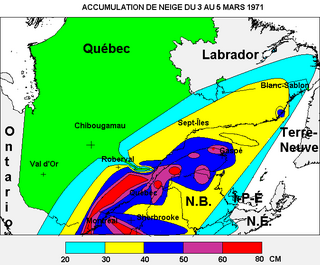
The Eastern Canadian blizzard of March 1971 was a severe winter storm that struck portions of eastern Canada from March 3 to March 5, 1971. The storm was also nicknamed the "Storm of the Century" in Quebec. The event included the worst 24-hour snowfall on record in the city of Montreal with 43 centimetres of snow falling on March 4, for a total of 47 centimetres, until the one-day record was broken again on December 27, 2012. Higher terrain in eastern Quebec received as much as 80 centimetres. Heavy snowfall was also recorded in eastern Ontario and northern New Brunswick as well as parts of the Northeastern United States. The storm itself was responsible for the deaths of 17 people in Montreal along with numerous other injuries directly and indirectly attributed to the blizzard.

Global storm activity of 2008 profiles the major worldwide storms, including blizzards, ice storms, and other winter events, from January 1, 2008 to December 31, 2008. A winter storm is an event in which the dominant varieties of precipitation are forms that only occur at cold temperatures, such as snow or sleet, or a rainstorm where ground temperatures are cold enough to allow ice to form. It may be marked by strong wind, thunder and lightning, heavy precipitation, such as ice, or wind transporting some substance through the atmosphere. Major dust storms, Hurricanes, cyclones, tornados, gales, flooding and rainstorms are also caused by such phenomena to a lesser or greater existent.
Global weather activity of 2007 profiles the major worldwide weather events, including blizzards, ice storms, tornadoes, tropical cyclones, and other weather events, from January 1, 2007, to December 31, 2007. Winter storms are events in which the dominant varieties of precipitation are formed during cold temperatures; they include snow or sleet, or a rainstorm where ground temperatures are cold enough to allow ice, including freezing rain, to form. Thehy may be marked by strong wind, thunder, lightning thunderstorms, heavy precipitation, including ice storm, wind transporting some substance through the atmosphere, including dust storms, snowstorms, and hail storms. Other major non winter events such as large dust storms, hurricanes, cyclones, tornados, gales, flooding, and rainstorms are also caused by such phenomena.

The 2011 Lake Champlain and Richelieu River floods were a series of water level increases that began at the end of April 2011 and caused a subsequent overflow of the Richelieu River in Canada and Lake Champlain in the United States. The flooding occurred due to record snowfall in the area followed by its snowmelt and in combination with intense spring rains. Lake Champlain stayed at flood stage for 67 days from April to June, and on May 10, 2011, the lake broke its previous flood level set in 1869 by reaching 102.8 ft. at Rouses Point, New York. The floods affected about 3,000 homes in Montérégie and caused an estimated six million U.S. dollars of damage in seven counties in the northern area of Vermont. The damage was so bad that a state of emergency was declared by Vermont on May 5, 2011. Similar damage was reported in New York State.

The Montreal flood of 1987 happened on July 14 of that year when a series of strong thunderstorms crossed the island of Montreal, Quebec, Canada, between the noon hour and 2:30 p.m. Over 100 millimetres (3.9 in) of rain fell during this very short period of time. The sewer systems were overwhelmed by the deluge and the city was paralyzed by the flooded roads. Autoroute 15, a sunken highway also known as the Décarie Expressway, soon filled with water, trapping motorists. Some 350,000 houses lost electricity, and tens of thousands had flooded basements. Two people died, one in a submerged car and another who was electrocuted.

The December 2013 North American storm complex was a significant storm complex that included many different types of severe weather, including a winter storm, a severe ice storm and a tornado outbreak that impacted the central and eastern portions of Canada, parts of the Central Great Plains, the Southern United States, and the northeastern United States from 20 to 23 December 2013. Formed in the South Central United States, the storm headed across the Great Plains towards Canada into Atlantic Canada and northeastern United States where the storm dissipated on 23 December 2013. The storm produced freezing rain and snow to the affected areas which caused massive damage to electric power transmission and trees. The storm resulted in 29 deaths, loss of power to over a million residents and over $200 million in damages. The storm produced similar conditions to the ice storm of 1998 which affected similar areas.

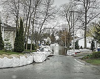
Spring snowfall and heavy rain caused floods in southern Quebec on 3 May 2017. In total, 5,371 residences were flooded, 4,066 people were forced from their homes, and 261 municipalities were affected, largely in the Outaouais Region, the Greater Montreal Area, the Montérégie, the Mauricie, the Gaspésie and the Côte-Nord regions. The floods were listed as the third most significant weather event of 2017 by the Canadian Meteorological and Oceanographic Society.
The zec Dumoine is a controlled harvesting zone located in the unorganized territory of Les Lacs-du-Témiscamingue, in the MRC Témiscamingue Regional County Municipality, in the administrative region of Abitibi-Témiscamingue, in Quebec, in Canada.