List of A roads in zone 9 in Great Britain starting north of the A8, east of the A9 (roads beginning with 9).
List of A roads in zone 9 in Great Britain starting north of the A8, east of the A9 (roads beginning with 9).
| Road | From | To | Notes |
|---|---|---|---|
| Falkirk | Scrabster | Formerly continued to John o' Groats; this became part of the A99 in 1997. | |
| Edinburgh | Fraserburgh | Via Perth and Aberdeen Western Peripheral Route. Originally had its north end in Dundee, but was extended north in the 1990s. | |
| St Andrews | Stirling | ||
| Dunfermline | Blackdog interchange | Via Tay Road Bridge, Dundee, Arbroath, Stonehaven and Aberdeen. Swapped with the A914 in the 1990s. Formerly continued north to Fraserburgh; this became the A90 and A952 in the 1990s. There is a dispute about the designation for the Cowdenbeath Spur leading from the M90 (J2A) onto the A92.[ citation needed ] | |
| Perth | Aberdeen | Via Braemar. Section east of Holburn Street declassified in 2020 due to the opening of the Aberdeen Western Peripheral Route; this section is now Willowbank Road, Springbank Terrace, College Street, and Guild Street. | |
| Perth | Forfar | Via Coupar Angus. Formerly continued north to Stonehaven; this became part of the A90 in the 1990s. | |
| Aviemore | Banff | ||
| Aberdeen | Inverness | Originally ran along Gallowgate on the east end. This was declassified by the 1980s, and the A96 was rerouted over a portion of the A946. | |
| Banff | Dinnet | ||
| Fraserburgh | Fochabers | ||
| Latheron | John o' Groats | Formerly a portion of the A9 (and the A88, A882 and B875 before that) until 1997. An older routing went from the A80 in Pirnhall to the A9 in Bannockburn. Renumbered to a portion of the A91 in the late 1980s. |
| Road | From | To | Notes |
|---|---|---|---|
| Edinburgh | Leith | Leith Street / Leith Walk / Constitution Street | |
| Leith | Granton | Great Junction Street / North Junction Street / Lindsay Road / Pier Place / Starbank Road / Lower Granton Road | |
| Leith | Maybury | Ferry Road / Telford Road / [joins A90 Queensferry Road] / Maybury Road | |
| Granton | Trinity | Granton Road | |
| South Queensferry | Falkirk | ||
| Grangemouth | Stirling | ||
| Ran from the A823 in Dunfermline to the A90 in Inverkeithing. The southern section was renumbered as an eastern extension of the A985 between 1948 and 1951 (based on maps) and the northern half was downgraded to the B9156 in the mid 1980s. Following construction of the M90, the A90 was downgraded and the eastern end of the ex-A906 is now part of the A921 (the A985 was cut back to the M90). | |||
| Stirling | Crossgates | ||
| Alloa | Tillicoultry | ||
| Burntisland | Kelty | ||
| Kirkcaldy | Kirkcaldy | ||
| Windygates | Milnathort | ||
| Perth | Muirhead | ||
| Cupar | Aberargie | ||
| Muirhead | Newport-on-Tay | Swapped with the A92 in the 1990s. | |
| Kirkcaldy | St Andrews | ||
| Windygates | Cupar | ||
| Largo | St Andrews | Coast road via Crail | |
| St Andrews | St Andrews | ||
| St Michaels | Guardbridge | ||
| Ellon | Dufftown | Originally allocated to a road from A90 (now A912) in Perth east and north via Marshall Place and Tay Street to A85 (now A989) & A921 (now South Street). Renumbered to a portion of the A94 in 1936 and is now part of the A989. Later allocated to a road from Dufftown to Keith; this became the B9014 when the current A920 replaced the old B9014 from Dufftown to Huntly and other roads. | |
| Kirkcaldy | M90 | Originally allocated to a road from A9 (now Caledonian Road) in Perth via York Place, County Place, and South Street to A85 & A920. Became a spur of the A85 in 1936 and is now unclassified. Later allocated between 1947 and 1955 (based on maps) to a road from Upper Largo to north of Crail as a replacement of the A917 and B942. The A917 and B942 got their sections back while the remainder was downgraded to the B9171. | |
| Kinross | Kinross | Previously allocated to a road from South Street (then A85) in Perth north to West Bridge Street (then A94). Renumbered to a portion of the A94 in 1936, and shown as a spur of the A85 by the mid 1960s, but is now part of the A85 mainline due to creation of the A989. | |
| Dundee | Dunkeld | ||
| Pitlochry | Bridge of Cally | ||
| A923 in Blairgowrie | A93 in Blairgowrie | ||
| Forfar | Blairgowrie | ||
| Ran from A923 northwest of Dundee to downtown Alyth. The section north of the A926 became the B952 and the southern section became the B954. | |||
| Kirriemuir | Todhills, A90 | ||
| Dundee | Dundee | Dual labelling of King Street (after North Marketgait) / Princes Street and Victoria Road (from Ladywell Roundabout) / Arthurstone Terrace, combining as Albert Street / Forfar Road to meet the A972. Formerly continued north to Forfar; this section became part of the A90 in the 1990s. [1] | |
| Dundee | Carnoustie | ||
| Ran from A92 via Dock Street to A92 (now A991) in Dundee; this became part of a rerouted A92, while the old route of the A92 is now the B959, A929, and A991. | |||
| Forfar | Friockheim | The A932 joins the A90 in the west via a flat crossing. It was previously possible to join the A90 in both directions, now it is only possible to continue south. [2] | |
| Brechin | Arbroath | Formerly continued north via what is now the A935 and B966 to Clerk Street (then part of the A94); this section was eliminated when the A94 bypass (now A90 bypass) was built. | |
| Montrose | Glasterlaw | ||
| Brechin | Montrose | ||
| Ran from Southesk Street (then part of the A933) in Brechin via Panmure Street to Clerk Street (then part of the A94). Became part of the A935 when the A94 (now A90) bypass was built. | |||
| Laurencekirk | Montrose | ||
| Carrbridge | Dulnain Bridge | ||
| Nairn | Ballater | ||
| Forres | Dava | ||
| Lossiemouth | Rhynie | ||
| Cullen | Buckie | ||
| Ran from Banchory to Bridge of Dee. Downgraded to the B9077 and B974, probably due to rerouting of the A957 across Durris Bridge. | |||
| Aberdeen | Corgarff | ||
| Ran from the A9013 in Bridge of Dee (now unclassified Holburn Street) via Riverside Drive to the A956 in Aberdeen. Declassified in 2020 due to the opening of the Aberdeen Western Peripheral Route. | |||
| Ran from A96 (now George Street) in Aberdeen to Aberdeen Docks. Became a portion of a rerouted A96 in 1982 after two shopping malls were built over its southern end; the section up to King Street is still part of the A96, the section from King Street to Hanover Street is now the A956 and the remainder unclassified. | |||
| Aberdeen | Banff | ||
| Ellon | New Deer | Formerly continued to Turriff via what is now the B9170. | |
| Dornoch | Bonar Bridge | Previously allocated to a road from Peterhead to Toll of Birness. Became a portion of an extended A952 in 1935 and is now part of the A90 and A982. | |
| Peterhead | A98 at New Pitsligo | ||
| First used from the A950 via King Street to Queen Street (then the A952) in Peterhead; became a spur of the A952 in 1935 and is now part of the A982. Next used from A9 (now B9152) south of Aviemore to Coylumbridge, formerly a spur of the B970. Returned to the B970 around 1980 after the A9 Aviemore bypass opened. | |||
| Toll of Birness | Cortes | Originally went through Peterhead instead of Mintlaw; this became part of an extended A90 in the 1990s, and the number was reused on the section of the A92 that did not become part of the A90. | |
| A97, Castle Street, Banff | Harbour Place, Banff | Quayside. 300yds long. | |
| Ran as a loop off the A914 (now B946) via High Road in Newport-on-Tay; this became part of the B946 when the Tay road bridge was built, causing the A92 to be extended and the A914 (which later was swapped with the A92) to be rerouted to bypass Newport-on-Tay. A 1966 map lists the route as part of the A914 (a typo). | |||
| Kirkcaldy | Leven | ||
| Bridge of Don, Aberdeen | A90 at Cleanhill (near Maryculter) | Includes King Street, Market Street and Wellington Road in Aberdeen; extended from Charlestown to Cleanhill in 2018 as part of AWPR | |
| Stonehaven | Crathes | Known as the Slug Road; formerly the B978 before it was upgraded. | |
| Ran from Muirdrum to Forfar; formerly the B963. Downgraded to the B9128 in the 1970s; the northernmost section is now part of the A932 Forfar relief road. | |||
| Ran from Anstruther to Brownhills; formerly the B944. Downgraded to the B9131 in the 1970s. | |||
| Kirkwall | Deerness | ||
| Kirkwall | Burwick | ||
| Broad Street, Kirkwall | Junction Road, Kirkwall | Great Britain's shortest "A road". | |
| Kirkwall | Junction with A961 | ||
| Kirkwall | Junction with A965 | ||
| Kirkwall | Stromness | ||
| Finstown | Birsay | ||
| Stromness | Birsay | ||
| Voe | Haroldswick | Includes two ferry crossings. Previously allocated to a road from Lerwick to Sumburgh; this became part of the A970 when the current route was created. | |
| Lerwick | Lerwick | Formerly continued west to Scalloway via what is now a spur of the A970. | |
| Sumburgh | North Roe | Spurs to Scalloway and Hillswick | |
| Tingwall | Sandness | Spur to Walls | |
| Dundee | Dundee | Formerly continued west to the A90 (now A85); this section became part of the A90 in the 1990s, [1] while the old route of the A90 in Dundee became an extension of the A85. | |
| Ran from Crathie to Potarch. Due to two Class I routes running parallel (the A973 paralleled the A93), it was downgraded before 1974 with much of the route becoming an extension of the B976 and the remainder a detached section of the B993. | |||
| Ran from Ordie to Westhill, formerly the B974. Downgraded to the B9119 in the 1970s; the easternmost section is now part of the A944. | |||
| A90 (Rashierieve nr Newburgh) | Longhaven (A90) | Aberdeen–Peterhead coastal route | |
| Ran from A907 to A823 in Dunfermline via Baldridgeburn, Mill Street, and Foundry Street; the Baldridgeburn section was downgraded to the B9155 and the rest declassified after 1973. | |||
| Kincardine Bridge | Kinross | ||
| Ran from the A956 in Old Aberdeen via St. Machar Drive, Hilton Street, Westburn Drive, Argyll Place, Westfield Road, Craigie Loanings, Albert Street, Waverley Place, Victoria Street, Alford Place, and Ubion Street to the A9013 (now Holburn Street) in Holburn Junction. In 2020, the section along St. Machar Drive was redesignated as the B991 and the remainder was declassified due to the opening of the Aberdeen Western Peripheral Route. | |||
| Ran from Oyne to Gartly. Downgraded in the 1970s (but before 1974) to the B9002. | |||
| Alford, Aberdeenshire | Banchory | ||
| New Deer | Fraserburgh | Formerly continued to Inverurie via what is now the B9170. | |
| Peterhead, South A90 Junction | Peterhead, North Road (A90) | Former alignment of A90. Previously allocated to Telford Road from A90 to Ferry Road (then part of the A902) in Edinburgh; this became part of a rerouted A902, while the old route of A902 became the B9085. | |
| Ran from Falkland to southeast of Newburgh; originally the B936. Downgraded back to the B936 after 1974, possibly due to the opening of the M90. | |||
| Coupar Angus | Dunkeld | ||
| Kincardine | Inverkeithing | Now incorporates the Kincardine Bridge. | |
| Finstown | Twatt | ||
| Ran from Kirkcaldy to west of Aberdour; formerly the B924. Downgraded to the B9157 in the late 1980s due to the opening of the new A92. Previously allocated to another road, probably in Perth, but it is unknown where that road was. | |||
| Ran from A910 to A921 north of Kirkcaldy; formerly the B926. Downgraded to the B981 in the late 1980s due to the opening of the new A92. Previously allocated to another road, probably in Perth, but it is unknown where that road was. | |||
| Perth | Perth | Perth Inner Ring Road, former sections of the A9, A85, A90, A94 and A920. | |
| Broadley | Buckie | ||
| Dundee | Dundee | Dundee Inner Ring Road | |
| Unused | |||
| Bo'ness | Muirhouses | ||
| Dunfermline | Cairneyhill, at Cairneyhill Roundabout | ||
| Unused | |||
| Ran from A9 to A91 north of Stirling Declassified in the early 1970s, but was upgraded to Class II status as the B998. | |||
| Unused |
| Road | From | To | Notes |
|---|---|---|---|
| South Queensferry | North Queensferry | New road created on 30 August 2017 as a renumbering of the A90 over the Forth Road Bridge as the Queensferry Crossing opened. A short section of original dual carriageway which carried the A90 from the current M90 southern extension can be seen between the eastern carriageway of the A9000 and the southbound slip onto the M90. | |
| Ran from A92 via Ashgrove Road West to A978 (now unclassified Westburn Drive) in Stockethill. Declassified in 2020 due to the opening of the Aberdeen Western Peripheral Route. | |||
| Ran from A92 in Ashgrove via Rosehill Drive to A978 (now unclassified Hilton Street and Westburn Drive) in Northfield. Declassified in 2020 due to the opening of the Aberdeen Western Peripheral Route. | |||
| Ran from the A92 in Bridge of Dee via Holburn Street, Union Street, and King Street in Aberdeen to the A956. Declassified in 2020 due to the opening of the Aberdeen Western Peripheral Route. | |||
| A9103 | Possible typo for the A9013. | ||
| Kingswells | Aberdeen | Renumbering of a portion of the B9119 in 2020 due to the opening of the Aberdeen Western Peripheral Route. |

Transport in the United Kingdom is highly facilitated by road, rail, air and water networks. Transport is a devolved matter with each of the countries of the United Kingdom having separate systems under separate governments.

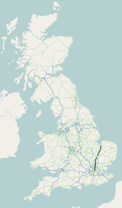
The M6 motorway is the longest motorway in the United Kingdom. It is located entirely within England, running for just over 230 miles (370 km) from the Midlands to the border with Scotland. It begins at Junction 19 of the M1 and the western end of the A14 at the Catthorpe Interchange, near Rugby before heading north-west. It passes Coventry, Birmingham, Wolverhampton, Stoke-on-Trent, Preston, Lancaster and Carlisle before terminating at Junction 45 near Gretna. Here, just short of the Scottish border it becomes the A74(M) which continues to Glasgow as the M74. Its busiest sections are between junctions 4 and 10a in the West Midlands, and junctions 16 to 19 in Cheshire; these sections have now been converted to smart motorways.
The A1, also known as the Great North Road, is the longest numbered road in the United Kingdom, at 410 miles (660 km). It connects London, the capital of England, with Edinburgh, the capital of Scotland. The numbering system for A-roads, devised in the early 1920s, was based around patterns of roads radiating from two hubs at London and Edinburgh. The first number in the system, A1, was given to the most important part of that system: the road from London to Edinburgh, joining the two central points of the system and linking the UK's (then) two mainland capital cities. It passes through or near north London, Hatfield, Welwyn Garden City, Stevenage, Baldock, Letchworth Garden City, Biggleswade, Eaton Socon, Buckden, Peterborough, Stamford, Grantham, Newark-on-Trent, Retford, Doncaster, Pontefract, York, Wetherby, Ripon, Darlington, Durham, Gateshead, Newcastle upon Tyne, Morpeth, Alnwick and Berwick-upon-Tweed.

The Great Britain road numbering scheme is a numbering scheme used to classify and identify all roads in Great Britain. Each road is given a single letter and a subsequent number. Though this scheme was introduced merely to simplify funding allocations, it soon became used on maps and as a method of navigation. There are two sub-schemes in use: one for motorways, and another for non-motorway roads.

The Westway is a 2.5-mile (4 km) elevated dual carriageway section of the A40 trunk road in West London running from Paddington in the east to North Kensington in the west. It connects the London Inner Ring Road to the West London suburbs.
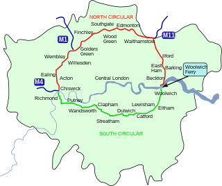
The South Circular Road in south London, England, is a major road that runs from the Woolwich Ferry in the east to the Chiswick Flyover in the west via Eltham, Lee Green, Catford, Forest Hill, Dulwich, Tulse Hill, Clapham Common, Clapham Junction, Wandsworth, Putney, Barnes, Mortlake and Kew Bridge. Together with the North Circular Road and Woolwich Ferry, it makes a complete ring-road around Central London and is a former boundary of the Ultra Low Emission Zone. The South Circular is largely a sequence of urban streets joined together, requiring several at-grade turns, unlike the mostly purpose-made carriageways of the North Circular. As a result, it is frequently congested.
The A10 is a major road in England which runs between The City of London and King's Lynn in Norfolk.

The M48 is a 13-mile (21 km) long motorway in Great Britain, which crosses the Severn near Chepstow, Monmouthshire, linking England with Wales via the Severn Bridge. This road used to be the M4, and as a result is anomalously numbered: as it lies to the north of the M4 and to the west of the M5, it is in the Motorway Zone 5. The M4, M48 and the A48(M) motorway are the only motorways in Wales.
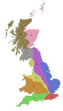
In the Great Britain road numbering scheme, the country is divided into numbered zones, the boundaries of which are usually defined by single-digit roads. The first digit of a road's number should be the number of the zone it occupies. If the road occupies multiple zones, then the furthest-anticlockwise zone is the correct one. The following tables list all British roads which are anomalously numbered. Roads in bold lie completely outside their "correct" zone; all other roads run for some length in their "correct" zones but trespass into zones anticlockwise of this zone. A further table lists duplicated road numbers.

England has a dense, multimodal transportation infrastructure. The Department for Transport is the government department responsible for the transport network in England. The Secretary of State for Transport is the member of the cabinet responsible to Parliament for the Department for Transport.
The United Kingdom has a well developed and extensive network of roads totalling about 262,300 miles (422,100 km). Road distances are shown in miles or yards and UK speed limits are indicated in miles per hour (mph) or by the use of the national speed limit (NSL) symbol. Some vehicle categories have various lower maximum limits enforced by speed limiters. A unified numbering system is in place for Great Britain, whilst in Northern Ireland, there is no available explanation for the allocation of road numbers.

The A120 is an A-road in England, which runs between Puckeridge in Hertfordshire and Harwich in Essex.

List of A roads in the zone 7 in Great Britain starting north of the Solway Firth/Eden Estuary, west of the A7 and south of the A8. Data from Openstreetmap.
List of A roads in zone 8 in Great Britain starting north of the A8 and west of the A9.
B roads are numbered routes in Great Britain of lesser importance than A roads. See the article Great Britain road numbering scheme for the rationale behind the numbers allocated.
B roads are numbered routes in Great Britain of lesser importance than A roads. See the article Great Britain road numbering scheme for the rationale behind the numbers allocated.
B roads are numbered routes in Great Britain of lesser importance than A roads. See the article Great Britain road numbering scheme for the rationale behind the numbers allocated.
These are lists of roads in the United Kingdom.

The London Low Emission Zone (LEZ) is an area of London in which an emissions standard based charge is applied to non-compliant commercial vehicles. Its aim is to reduce the exhaust emissions of diesel-powered vehicles in London. This scheme should not be confused with the Ultra Low Emission Zone (ULEZ), introduced in April 2019, which applies to all vehicles. Vehicles that do not conform to various emission standards are charged; the others may enter the controlled zone free of charge. The low emission zone started operating on 4 February 2008 with phased introduction of an increasingly stricter regime until 3 January 2012. The scheme is administered by the Transport for London executive agency within the Greater London Authority.

Road speed limits in the United Kingdom are used to define the maximum legal speed for vehicles using public roads in the UK.