This list of motorways in the United Kingdom is a complete list of motorways in the United Kingdom. Note that the numbering scheme used for Great Britain does not include roads in Northern Ireland, which are allocated numbers on an ad hoc basis. [1]
Link | Route | Ceremonial counties (England) Council areas (Scotland) Principal areas (Wales) | Highest junction to junction average daily vehicle flow 2019 [2] | Length | |
---|---|---|---|---|---|
mi | km | ||||
M1 | A south-north motorway linking London to Leeds. The first long-distance motorway in the country to be built. [3] | Greater London, Hertfordshire, Bedfordshire, Buckinghamshire, Northamptonshire, Leicestershire, Nottinghamshire, Derbyshire, South Yorkshire, West Yorkshire | 168,763 | 193.5 | 311.4 |
M2 | A west-east motorway bypassing Medway, Sittingbourne and Faversham. | Kent | 106,582 | 25.7 | 41.4 |
M3 | A northeast-southwest motorway linking London to Southampton. | Surrey, Hampshire | 136,059 | 58.6 | 94.3 |
M4 | An east-west motorway linking London to Cardiff and South Wales. | Greater London, Buckinghamshire, Berkshire, Wiltshire, Gloucestershire, Monmouthshire, Newport, Cardiff, Vale of Glamorgan, Rhondda Cynon Taff, Bridgend, Neath Port Talbot, Swansea, Carmarthenshire | 161,807 | 189 | 304 |
M5 | A northeast-southwest motorway in South West England, linking Birmingham to Exeter. | West Midlands, Worcestershire, Gloucestershire, Bristol, Somerset, Devon | 127,584 | 162.9 | 262.2 |
M6 | A southeast-northwest motorway linking the West Midlands to North West England and Scotland. Continues as A74(M). The first and longest motorway in the country to be built. [3] | Leicestershire, Warwickshire, West Midlands, Staffordshire, Cheshire, Merseyside, Greater Manchester, Lancashire, Cumbria | 173,201 | 232.2 | 373.7 |
M6 Toll | A tolled bypass of the M6 in the West Midlands. | West Midlands, Staffordshire, Warwickshire | 110,489 | 27 | 43 |
M8 | An east-west motorway linking Edinburgh to Glasgow. | Edinburgh, West Lothian, North Lanarkshire, Glasgow, Renfrewshire | 160,484 | 60.3 | 97.0 |
M9 | A southeast-northwest motorway linking Edinburgh to Stirling. | Edinburgh, West Lothian, Falkirk, Stirling | 68,143 | 33.0 | 53.1 |
M11 | A south-north motorway linking London to Cambridge. | Greater London, Essex, Cambridgeshire | 121,964 | 55.0 | 88.5 |
M18 | A southwest-northeast motorway linking the M1 to the M62. | South Yorkshire, East Riding of Yorkshire | 108,855 | 26.5 | 42.6 |
M20 | A west-east motorway linking London to Folkestone and the Channel Tunnel. | Kent | 120,348 | 50.6 | 81.4 |
M23 | A north-south motorway linking London to Gatwick Airport and Crawley. | Surrey, West Sussex | 110,574 | 15.9 | 25.6 |
M25 | A ring road of London numbered clockwise from Dartford. | Kent, Surrey, Berkshire, Greater London, Buckinghamshire, Hertfordshire, Essex | 216,108 | 117 | 188 |
M26 | An east-west motorway linking the M25 to the M20. | Kent | 70,674 | 9.9 | 15.9 |
M27 | A west-east motorway linking Southampton to Portsmouth. | Hampshire | 134,210 | 25.0 | 40.2 |
M32 | A spur from the M4 into central Bristol. | Gloucestershire, Bristol | 84,898 | 4.4 | 7.1 |
M40 | A southeast-northwest motorway linking London to Birmingham. | Buckinghamshire, Oxfordshire, Northamptonshire, Warwickshire | 133,490 | 89.0 | 143.2 |
M42 | A motorway bypassing Birmingham to the south and east, continuing to the M1 at Kegworth as the A42. | Worcestershire, Warwickshire, West Midlands, Leicestershire | 154,532 | 40.0 | 64.4 |
M45 | A spur from the M1 south of Rugby. | Warwickshire, Northamptonshire | 19,536 | 7.9 | 12.7 |
M48 | An alternative route to the M4 between Bristol and Caldicot. | Gloucestershire, Monmouthshire | 22,632 | 12 | 19 |
M49 | A western bypass of Bristol. | Bristol, Gloucestershire | 22,461 | 5.0 | 8.0 |
M50 | A west-east motorway between the M5 and Ross-on-Wye. | Worcestershire, Gloucestershire, Herefordshire | 32,032 | 21.6 | 34.8 |
M53 | A north-south motorway linking Birkenhead (and Liverpool via Kingsway Tunnel) to Chester. | Merseyside, Cheshire | 79,872 | 18.9 | 30.4 |
M54 | An east-west motorway linking Wolverhampton to Telford. | Staffordshire, Shropshire | 70,652 | 23.0 | 37.0 |
M55 | An east-west motorway linking Preston to Blackpool. | Lancashire | 84,905 | 12.2 | 19.6 |
M56 | A west-east motorway linking Manchester to Liverpool and Chester. | Greater Manchester, Cheshire | 174,693 | 33.3 | 53.6 |
M57 | An eastern bypass of Liverpool linking the M62 to Maghull. | Merseyside | 99,521 | 10 | 16 |
M58 | A west-east motorway linking Liverpool to Wigan. | Merseyside, Lancashire, Greater Manchester | 49,376 | 12 | 19 |
M60 | A ring road of Manchester numbered clockwise from Stockport. | Greater Manchester | 180,501 | 36 | 58 |
M61 | A north-south motorway linking Preston to Manchester. | Greater Manchester, Lancashire | 150,331 | 20.0 | 32.2 |
M62 | A west-east motorway linking Liverpool to Hull. | Merseyside, Cheshire, Greater Manchester, West Yorkshire, North Yorkshire, East Riding of Yorkshire | 161,700 | 107 | 172 |
M65 | A west-east motorway linking Preston to Burnley and Colne. | Lancashire | 82,970 | 25.8 | 41.5 |
M66 | A north-south motorway linking Ramsbottom to Manchester. | Lancashire, Greater Manchester | 111,851 | 8.0 | 12.9 |
M67 | A west-east motorway linking Manchester to Hadfield. | Greater Manchester | 58,435 | 5.0 | 8.0 |
M69 | A northeast-southwest motorway linking Leicester to Coventry. | Warwickshire, Leicestershire | 64,828 | 15.7 | 25.3 |
M73 | An eastern bypass of Glasgow. | North Lanarkshire, Glasgow, South Lanarkshire | 95,331 | 7.0 | 11.3 |
M74 | A northwest-southeast motorway linking Glasgow to North West England. Continues as the A74(M) south of Abington. | Glasgow, North Lanarkshire, South Lanarkshire | 107,475 | 40 | 60 |
M77 | A north-south motorway linking Glasgow to Kilmarnock. | Glasgow, East Renfrewshire, East Ayrshire | 94,151 | 20.0 | 32.2 |
M80 | A southwest-northeast motorway linking Glasgow to Stirling. | Glasgow, North Lanarkshire, Falkirk, Stirling | 104,305 | 25.0 | 40.2 |
M90 | A south-north motorway linking Edinburgh to Perth. | Edinburgh, Fife, Perth and Kinross | 76,503 | 36.0 | 57.9 |
M180 | A west-east motorway linking Thorne to Grimsby. Continues as the A180 after the exit for the Humber Bridge. | South Yorkshire, Lincolnshire | 48,780 | 25.0 | 40.2 |
M181 | A spur of the M180 leading to Scunthorpe. | Lincolnshire | 18,213 | 2.0 | 3.2 |
M271 | A spur of the M27 bypassing Southampton to the west. | Hampshire | 53,678 | 2.3 | 3.7 |
M275 | A spur from the M27 to central Portsmouth and Cosham. | 86,291 | 2.0 | 3.2 | |
M602 | A west-east motorway linking the M62 to Salford. | Greater Manchester | 73,292 | 4.0 | 6.4 |
M606 | A spur from the M62 to Bradford. | West Yorkshire | 77,277 | 3.0 | 4.8 |
M621 | An east-west motorway linking Leeds to the M1 and M62. | 103,207 | 7.7 | 12.4 | |
M876 | A southwest-northeast motorway linking Bonnybridge to Kincardine. | Falkirk | 42,611 | 8.0 | 12.9 |
M898 | A spur from the M8 leading to Erskine Bridge. | Renfrewshire | 51,831 | 0.5 | 0.8 |
Link | Route | Ceremonial counties (England) Council areas (Scotland) Principal areas (Wales) | Highest junction to junction average daily vehicle flow 2019 [2] |
---|---|---|---|
A1(M) | A south-north motorway split into four sections:
| Hertfordshire, Bedfordshire, Cambridgeshire, Nottinghamshire, South Yorkshire, West Yorkshire, North Yorkshire, County Durham, Tyne and Wear | 143,012 |
A3(M) | A north-south motorway linking the A3 to the A27 near Portsmouth. | Hampshire | 92,989 |
A8(M) | A spur from the M8 and M73 to Ballieston. | Glasgow | 10,586 |
A38(M) | A spur from the M6 to central Birmingham. | West Midlands | 146,908 |
A48(M) | A spur from the M4 to central Cardiff. | Newport, Cardiff | 47,203 |
A57(M) | Forms part of a ring road of Manchester. Also known as the Mancunian Way. | Greater Manchester | 90,785 |
A58(M) | Forms the western part of the Leeds inner ring road. | West Yorkshire | 81,647 |
A64(M) | Forms the eastern part of the Leeds inner ring road. | 43,617 | |
A66(M) | A spur from the A1(M) to the A66 south of Darlington. | North Yorkshire | 15,337 |
A74(M) | A northwest-southeast motorway linking the M74 to North West England. Continues as the M6. | South Lanarkshire, Dumfries and Galloway, Cumbria | 41,662 |
A167(M) | An urban motorway in Newcastle-Upon-Tyne. | Tyne and Wear | 63,911 |
A194(M) | A south-north motorway linking the A1(M) to the Tyne Tunnel. | 42,802 | |
A308(M) | A spur from the M4 south of Maidenhead. | Berkshire | 23,541 |
A329(M) | A southeast-northwest motorway linking Bracknell to Reading. | 69,520 | |
A404(M) | A spur from the M4 to High Wycombe. Continues as the A404 west of Maidenhead. | 59,816 | |
A627(M) | A south-north motorway linking Rochdale to Oldham. | Greater Manchester | 55,749 |
A823(M) | A spur from the M90 to Dunfermline. | Fife | 20,363 |
A1077(M) | A spur from the M181 to Scunthorpe. | Lincolnshire | 18,213 |
Link | Description |
---|---|
M10 | A spur that ran from the M1 to St Albans, now part of the A414. |
M41 | The former number for the West Cross Route, now part of the A3220 road. [4] |
A40(M) | The former number for the Westway, now part of the A40. [4] |
A102(M) | The former number for the East Cross Route, split into two sections:
|
A601(M) | A spur that ran from the M6 to Carnforth and Over Kellet. Now part of the A6070 and B6601. [5] [6] |
A6144(M) | A spur that ran from the M60 to Carrington. It was unique for being single carriageway throughout. |
Link | Route | Council areas |
---|---|---|
M1 | An east-west motorway linking Belfast to Dungannon. Continues as the A4. | Belfast, Lisburn and Castlereagh, Armagh City, Banbridge and Craigavon, Mid Ulster |
M2 | A southeast-northwest motorway split into two sections: Continues as the A26. | Belfast, Antrim and Newtownabbey, Mid and East Antrim |
M3 | A spur from the M2 to the A2 in east Belfast. | Belfast |
M5 | A spur from the M2 to Newtownabbey in north Belfast. | Belfast, Antrim and Newtownabbey |
M12 | A spur from the M1 to Portadown. | Armagh City, Banbridge and Craigavon |
M22 | A spur from the M2 to Randalstown. Continues as the A6. | Antrim and Newtownabbey |
Link | Route | Council areas |
---|---|---|
A8(M) | A spur from the M2 to the A8 northwest of Newtownabbey. | Antrim and Newtownabbey |
The M6 motorway is the longest motorway in the United Kingdom. It is located entirely within England, running for just over 230 miles (370 km) from the Midlands to the border with Scotland. It begins at Junction 19 of the M1 and the western end of the A14 at the Catthorpe Interchange, near Rugby before heading north-west. It passes Coventry, Birmingham, Wolverhampton, Stoke-on-Trent, Preston, Lancaster and Carlisle before terminating at Junction 45 near Gretna. Here, just short of the Scottish border it becomes the A74(M) which continues to Glasgow as the M74. Its busiest sections are between junctions 4 and 10a in the West Midlands, and junctions 16 to 19 in Cheshire; these sections have now been converted to smart motorways.
The M1 motorway connects London to Leeds, where it joins the A1(M) near Aberford, to connect to Newcastle. It was the first inter-urban motorway to be completed in the UK; the first motorway in the country was the Preston Bypass, which later became part of the M6.
The M60 motorway, Manchester Ring Motorway or Manchester Outer Ring Road is an orbital motorway in North West England. Built over a 40-year period, it passes through most of Greater Manchester's metropolitan boroughs except for Wigan and Bolton. Most of Manchester is encompassed within the motorway, except for the southernmost part of the city which is served by the M56.
Heysham is a coastal village in the Lancaster district of Lancashire, England, overlooking Morecambe Bay. It is a ferry port, with services to the Isle of Man and Ireland, and the site of two nuclear power stations.
The M65 is a motorway between Preston and Colne in Lancashire, England. It runs from Bamber Bridge just south of Preston, through major junctions with the M6 and M61 motorways, east past Darwen, Blackburn, Accrington, Burnley, Brierfield, Nelson and ends at Colne.
The M7 motorway is a motorway in Ireland. The motorway runs continuously from the outskirts of Naas in County Kildare to Rossbrien on the outskirts of Limerick city. The M7 forms part of the Dublin to Limerick N7 national primary road. The section of the motorway bypassing Naas, an 8 km stretch, was the first section of motorway to open in Ireland, in 1983. Following substantial works to extend the M7 to Limerick, by the end of 2010, the motorway replaced all of the old single-carriageway N7 route which is now designated as R445. At 166.5 km, the M7 is the longest motorway in Ireland.
Darwen is a market town and civil parish in the Blackburn with Darwen borough in Lancashire, England. The residents of the town are known as "Darreners". The A666 road passes through Darwen towards Blackburn to the north, Bolton to the south and Pendlebury where it joins the A6, about 18 miles (29 km) north-west of Manchester. The population of Darwen stood at 28,046 in the 2011 census. The town comprises four wards and has its own town council.
Carnforth is a market town and civil parish in the City of Lancaster in Lancashire, England, situated at the north-east end of Morecambe Bay. The parish of Carnforth had a population of 5,560 in the 2011 census, an increase from the 5,350 recorded in the 2001 census. The town is situated around 7 miles north of Lancaster, 17 miles south of Kendal, 40 miles east of Barrow-in-Furness and 28 miles northwest of Settle. The town is also close to the Cumbria/Lancashire border.
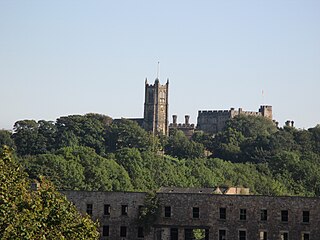
The City of Lancaster, or simply Lancaster, is a local government district with city status in Lancashire, England. It is named after its largest settlement, Lancaster, and also includes the towns of Carnforth, Heysham and Morecambe and a wider rural hinterland. The district has a population of 144,446 (2022), and an area of 219 square miles (567 km2).
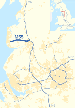
The M55 is a motorway in Lancashire, England, which can also be referred to as the Preston Northern Bypass. It connects the seaside resort of Blackpool to the M6 at Preston. It is 12.2 miles (19.6 km) in length.
The M57 motorway, also known as the Liverpool Outer Ring Road, is a motorway in England. Designed as a ring road for Liverpool, it is 10 miles (16 km) long between Tarbock Green and Switch lsland, and links various towns east of the city, as well as the M62 and M58 motorways.
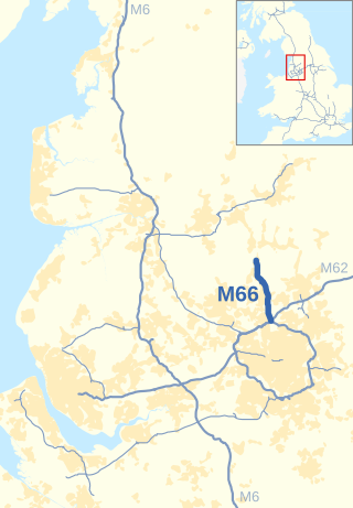
The M66, also known as the Bury Easterly Bypass, is a motorway in Lancashire and Greater Manchester, England. It is 8 miles (13 km) long and provides part of the route between the M62 and M60 motorways and the M65, with the rest being provided by the A56.
The N3 road is a national primary road in the Republic of Ireland, running between Dublin, Cavan and the border with County Fermanagh. The A509 and A46 roads in Northern Ireland form part of an overall route connecting to Enniskillen, and northwest to the border again where the N3 reappears to serve Ballyshannon in County Donegal.
The A601(M) was a motorway in Carnforth, Lancashire, England. It was at the time of its downgrade a 1.3 miles (2.1 km) long dual carriageway, meeting the M6 at Junction 35. It is no longer a motorway but remains open, as part of the B6601 and A6070.
The United Kingdom has a well developed and extensive network of roads totalling about 262,300 miles (422,100 km). Road distances are shown in miles or yards and UK speed limits are indicated in miles per hour (mph) or by the use of the national speed limit (NSL) symbol. Some vehicle categories have various lower maximum limits enforced by speed limiters. A unified numbering system is in place for Great Britain, whilst in Northern Ireland, there is no available explanation for the allocation of road numbers.
The main roads in Northern Ireland are signed "M"/"A"/"B" as in Great Britain. Whereas the roads in Great Britain are numbered according to a zonal system, there is no available explanation for the allocation of road numbers in Northern Ireland, though their numbering is separate from the system in England, Scotland and Wales.
A national primary road is a road classification in Ireland. National primary roads form the major routes between the major urban centres. There are 2649 km of national primary roads. This category of road has the prefix "N" followed by one or two digits. Motorways are prefixed "M" followed by one or two digits.
In Ireland, the highest category of road is a motorway, indicated by the prefix M followed by a one- or two-digit number. The motorway network consists entirely of motorway-grade dual carriageways and is largely focused upon Dublin. There are also several three-lane motorways, while Ireland's busiest road, the M50, incorporates four-lane, five-lane, and six-lane stretches.
The Preston Bypass was the United Kingdom's first motorway. It was designed and engineered by Lancashire County Council surveyor James Drake as part of a larger initiative to create a north-south motorway network that would later form part of the M6 motorway. The bypass was opened on 5 December 1958 by the then Prime Minister, Harold Macmillan. Nearly £3 million was spent on its construction. The original 8+1⁄4-mile (13.3 km) motorway ran around the east side of Preston between Bamber Bridge and Broughton and crosses over the River Ribble at Samlesbury at the M6 Junction 31.