
Forestdale is an unincorporated community and census-designated place (CDP) in Jefferson County, Alabama, United States. It is north of the Birmingham city neighborhood of Ensley. At the 2020 census, the population was 10,409.
Sleetmute is a census-designated place (CDP) in Bethel Census Area, Alaska, United States. At the 2010 census the population was 86, down from 100 in 2000.

Littletown was a census-designated place (CDP) in Pima County, Arizona, United States. The population was 1,010 at the 2000 census. The area was annexed into Tucson in 2017.

North Falmouth is a census-designated place (CDP) in the town of Falmouth in Barnstable County, Massachusetts, United States. The population was 3,084 at the 2010 census.
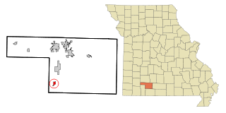
Spokane is a census-designated place in Christian County, Missouri, United States. The population was 177 at the 2010 census. It is part of the Springfield, Missouri, Metropolitan Statistical Area.

Villa Ridge is an unincorporated community and census-designated place (CDP) in Franklin County, Missouri, United States. The population was 2,636 at the 2010 census, up from 2,417 at the 2000 census.

Hartwell is a former village and census-designated place in Henry County, Missouri, United States. The population was 16 at the 2010 census.

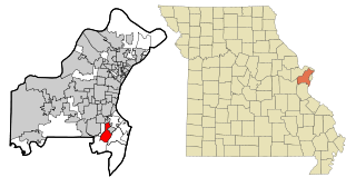
Horine is an unincorporated community and census-designated place (CDP) in Jefferson County, Missouri, United States. The population was 821 at the 2010 census, down from 923 in 2000.
Crestwood is a city in south St. Louis County, Missouri, United States, part of the Metropolitan Statistical Area known as Greater St. Louis. The population was 11,912 at the 2010 census.

Lemay is a census-designated place (CDP) in south St. Louis County, Missouri, United States. The population was 16,645 at the 2010 census.

Mehlville is a census-designated place (CDP) in south St. Louis County, Missouri, United States, an area locally known as "South County". It is an inner-ring suburb of St. Louis, and part of the Greater St. Louis metropolitan area.
Oakville is a census-designated place (CDP) in south St. Louis County, Missouri, United States. The population was 36,301 at the 2020 census. Oakville is 18 miles south of the city of St. Louis and borders the Mississippi and Meramec rivers; the area is part of "South County".

Lolo is a census-designated place (CDP) in Missoula County, Montana, United States. It is part of the Missoula Metropolitan Statistical Area. The population was 4,399 at the 2020 census, an increase from its population of 3,892 in 2010. It is home to Travelers' Rest State Park, a site where Lewis and Clark camped in 1805 and again in 1806.
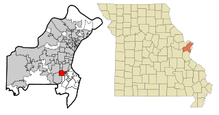
Concord is a census-designated place (CDP) in St. Louis County, Missouri, United States. The population was 16,421 at the 2010 census. It should not be confused with Concord Township; which the CDP shares much land with, but these areas' boundaries are not identical.

Twin Lakes is a census-designated place (CDP) in McKinley County, New Mexico, United States. The population was 1,069 at the 2000 census.
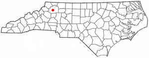
Millers Creek is a census-designated place (CDP) in Wilkes County, North Carolina, United States. The population was 2,112 at the 2010 census. West Wilkes High School, one of the four public high schools in Wilkes County, is located in Millers Creek.

Mission is an unincorporated community in Umatilla County, Oregon, United States. For statistical purposes, the United States Census Bureau has defined Mission as a census-designated place (CDP). The census definition of the area may not precisely correspond to local understanding of the area with the same name. The population was 1,019 at the 2000 census.

Harper is an unincorporated community and census-designated place (CDP), located 23 miles (37 km) west of Fredericksburg on U.S. Highway 290, in Gillespie County, in the U.S. state of Texas. The population was 1,192 at the 2010 census.

Matoaca is a census-designated place (CDP) in Chesterfield County, Virginia, United States. The population was 2,403 at the 2010 census. It is named after the Pamunkey princess Matoaka who was better known by her nickname "Pocahontas". It was near the site of an Appomattoc village Matoka or Matoks, which was reputedly her girlhood home, and the palace town of the weroansqua Oppussoquionuske.
Buena Ventura Lakes, more commonly known as BVL, is a census-designated place (CDP) in northern Osceola County, Florida, United States, near Kissimmee. Its population was 26,079 at the 2010 census. It is part of the Orlando–Kissimmee–Sanford, Florida Metropolitan Statistical Area. The community is served by the Osceola Library System.


