Alakanuk, Alaska

Last updated

Alakanuk
Alarneq (Central Yupik)
AUK-Aerial Map.jpg
Alakanuk Airport
USA Alaska location map.svg
Red pog.svg
Alakanuk
Location in Alaska
Coordinates: 62°41′5″N164°38′43″W / 62.68472°N 164.64528°W / 62.68472; -164.64528
CountryUnited States
State Alaska
Census area Kusilvak
Incorporated October 28, 1969 [1]
Government
   Mayor Thomas Alstrom [2]
   State senator Donny Olson (D)
   State rep. Neal Foster (D)
Area
[3]
  Total41.80 sq mi (108.26 km2)
  Land32.20 sq mi (83.40 km2)
  Water9.60 sq mi (24.86 km2)
Elevation
3 ft (1 m)
Population
 (2020) [4]
  Total756
  Density23.48/sq mi (9.07/km2)
Time zone UTC-9 (Alaska (AKST))
  Summer (DST) UTC-8 (AKDT)
ZIP code
99554
Area code 907
FIPS code 02-01200
GNIS feature ID 1398042

Alakanuk(ah-LUG-uh-nuck) (Central Yupik : Alarneq) is a second class city in the Kusilvak Census Area of the Unorganized Borough in the western part of the U.S. state of Alaska. As of the 2010 census, the population of the city was 677, up from 652 in 2000.

Contents

Location and climate

Alakanuk is located at 62.688890° North, 164.61528° West (Sec. 14, T030N, R082W, Seward Meridian). [5] Alakanuk is located in the Bethel Recording District.

Alakanuk is located at the east entrance of Alakanuk Pass, the major southern channel of the Yukon River, 15 miles (24 km) from the Bering Sea. It is part of the Yukon Delta National Wildlife Refuge. It lies 8 miles (13 km) southwest of Emmonak, approximately 162 miles (261 km) northwest of Bethel. It is the longest village on the lower Yukon - the development stretches over a 3-mile (4.8 km) area along the Pass. Approximately 25 homes along the bank are being threatened by erosion.

The climate of Alakanuk is subarctic, averaging 60 inches (1,500 mm) of snowfall and 19 inches (480 mm) of total precipitation per year. Temperatures range from −25 to 79 °F (−32 to 26 °C). Heavy winds are frequent during the fall and winter. The Yukon River is used as an ice road during freeze-up, from November through May.

According to the United States Census Bureau, the city has a total area of 41.0 square miles (106 km2), of which, 32.4 square miles (84 km2) of it is land and 8.7 square miles (23 km2) of it (21.14%) is water.

History and culture

Alakanuk is a Yup'ik word meaning "wrong way" or "mistake village", aptly applied to a village on this maze of watercourses. The village was first reported by G.R. Putnam of the U.S. Coast & Geodetic Survey in 1899. It was originally settled by a Yup'ik shaman named Anguksuar and his family. A Catholic mission school was built near the village. A post office was established in 1946. In 1948, the school was relocated to St. Mary's, and many families moved from the old school site to Alakanuk. It incorporated as a second-class city in 1969.

A federally recognized tribe is located in the community—the Village of Alakanuk.

Demographics

Historical population
CensusPop.Note
1940 61
1950 140129.5%
1960 27898.6%
1970 41448.9%
1980 52226.1%
1990 5444.2%
2000 65219.9%
2010 6773.8%
2020 756[ citation needed ]11.7%
U.S. Decennial Census [6] [ failed verification ]

Alakanuk first appeared on the 1940 U.S. Census as the unincorporated native village of "Alaganuck." [7] It returned as Alakanuk in 1950 [8] and every successive census to date (2010). [9] It formally incorporated in 1969.

As of the census [10] of 2000, there were 652 people, 139 households, and 118 families residing in the city. The population density was 20.2 people per square mile (7.8/km2). There were 160 housing units at an average density of 4.9 per square mile (1.9/km2). The racial makeup of the city was 1.99% White, 95.40% Native American, 0.15% Asian, and 2.45% from two or more races.

There were 139 households, out of which 59.7% had children under the age of 18 living with them, 57.6% were married couples living together, 12.9% had a female householder with no husband present, and 15.1% were non-families. 10.8% of all households were made up of individuals, and 2.9% had someone living alone who was 65 years of age or older. The average household size was 4.69 and the average family size was 5.19.

In the city, the age distribution of the population shows 44.6% under the age of 18, 12.9% from 18 to 24, 21.9% from 25 to 44, 13.7% from 45 to 64, and 6.9% who were 65 years of age or older. The median age was 20 years. For every 100 females, there were 111.0 males. For every 100 females age 18 and over, there were 109.9 males.

The median income for a household in the city was $26,346, and the median income for a family was $26,500. Males had a median income of $19,792 versus $32,500 for females. The per capita income for the city was $6,884. About 32.5% of families and 33.8% of the population were below the poverty line, including 34.1% of those under age 18 and 25.8% of those age 65 or over.

Facilities, utilities, and healthcare

The City operates the water and piped sewer system and the central watering point. Approximately 90% of homes are connected. There is a sewage lagoon available for individuals to dump their honey buckets. The City Council is the policy-making body for the utility. Water is derived from the Alakanuk Slough; it is treated, stored in a tank, and piped to most of the community. In 1998, 83 homes, the school and teachers' housing were connected to a new piped system. New facilities include a water treatment plant, heated 300,000-gal. water storage tank, vacuum sewage plant, sewage lagoon, Arctic piping, and household plumbing. A new subdivision is currently underway, and nine homes will be connected to the piped utilities. The city has funding from DEC for service connections to 20 homes. Ten homes have been moved from the erosion zone on the river bank and are ready for service. The city is planning to move an additional 10 homes. AVCP is building a 9-home subdivision, including water and sewer mains and service connections, for occupancy in 2002. The city completed a feasibility study for service area 7, which is the area across the river, and would like to obtain funding to make this expansion. The landfill is reported as inactive. Electricity is provided by AVEC. Local hospitals or health clinics include Alakanuk Health Clinic and Pearl E. Johnson Sub-Regional Clinic in Emmonak. Alakanuk Health Clinic is a Primary Health Care facility. Alakanuk is classified as an isolated village, located in EMS Region 7A in the Yukon/Kuskokwim Region. Emergency Services have coastal and air access. Emergency service is provided by a health aide.

The sale, importation and possession of alcohol are banned in the village. [11]

Education

K-12 students are zoned for Alakanuk School.

Economy and Transportation

Alakanuk experiences a seasonal economy. 76 residents hold commercial fishing permits. Many have gill net permits, and set net fishermen sell their salmon to Seattle fish buyers. Poor fish returns since 1998 have significantly affected the community. Government employment and retail businesses provide limited year-round employment. Salmon, beluga whale, seal, moose and rabbit provide food sources. Some residents trap. Many residents travel to Emmonak to shop and attend social events and basketball tournaments.

Alakanuk Airport, a State-owned 2,200' long by 55' wide gravel airstrip, is available. An airport relocation project is underway, due to erosion. Grant Aviation, Hageland Aviation and Tanana Air Service offer passenger flight service. Alakanuk is easily accessible from the Yukon River and Bering Sea by barge and riverboat. Most passengers and mail arrive by air. There are no roads connecting Alakanuk with other population centers in the region, but ice roads are used in winter. Snowmachines and boats are used for local travel.

Taxes: Sales: 4%, Property: None, Special: None

Notable people

Related Research Articles

<span class="mw-page-title-main">Kusilvak Census Area, Alaska</span> Census area in Alaska, United States

Kusilvak Census Area, formerly known as Wade Hampton Census Area, is a census area located in the U.S. state of Alaska. As of the 2020 census, the population was 8,368, up from 7,459 in 2010. It is part of the Unorganized Borough and therefore has no borough seat. Its largest community is the city of Hooper Bay, on the Bering Sea coast.

<span class="mw-page-title-main">Akutan, Alaska</span> City in Alaska, United States

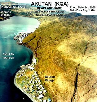
Akutan is a city on Akutan Island in the Aleutians East Borough of the Aleutian Islands in Alaska, United States. The population was 1,589 at the 2020 census, up from 1,027 in 2010, making it the 4th fastest-growing city of the decade in Alaska. Akutan Harbor is adjacent.

<span class="mw-page-title-main">Akiachak, Alaska</span> Census-designated place in Alaska, United States

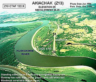
Akiachak is a census-designated place (CDP) in the Bethel Census Area in the U.S. state of Alaska. The population was 677 in the 2020 census, up from 627 in 2010, and 585 in 2000.

<span class="mw-page-title-main">Akiak, Alaska</span> City in Alaska, United States

Akiak(ACK-ee-ack) is a city in Bethel Census Area, Alaska, United States. The population was 462 at the 2020 census, up from 346 in 2010. It is the home of the Akiak Native Community.

<span class="mw-page-title-main">Bethel, Alaska</span> City in Alaska, United States

Bethel is a city in the U.S. state of Alaska, located on the Kuskokwim River approximately 50 miles (80 km) from where the river discharges into Kuskokwim Bay. It is the largest community in western Alaska and in the Unorganized Borough and the eighth-largest in the state. Bethel has a population of 6,325 as of the 2020 census, up from 6,080 in 2010.

<span class="mw-page-title-main">Akhiok, Alaska</span> City in Alaska, United States

Akhiok is a second-class city in Kodiak Island Borough, Alaska, United States. Akhiok is Kodiak's southernmost village. The population was 63 at the 2020 census. Akhiok, which does not have a post office, is a rural location in postal code 99615 that belongs to Kodiak. The village is sometimes called Alitak, after a nearby bay.

<span class="mw-page-title-main">Nondalton, Alaska</span> Town in Alaska, United States

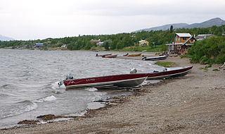
Nondalton is a town on the west shore of Six Mile Lake in the Lake and Peninsula Borough, Alaska, United States. At the 2020 census, the population was 133, down from 164 in 2010.

St. Michael, historically referred to as Saint Michael, is a city in Nome Census Area, Alaska. The population was 401 at the 2010 census, up from 368 in 2000.

<span class="mw-page-title-main">Unalakleet, Alaska</span> City in Alaska, United States

Unalakleet is a city in Nome Census Area, Alaska, United States, in the western part of the state. At the 2010 census the population was 688, down from 747 in 2000. Unalakleet is known in the region and around Alaska for its salmon and king crab harvests; the residents rely for much of their diet on caribou, ptarmigan, oogruk, and various salmon species.

<span class="mw-page-title-main">Alcan Border, Alaska</span> Census-designated place in Alaska, United States

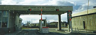
Alcan Border, also known as Port Alcan, is a census-designated place in the Southeast Fairbanks Census Area in the U.S. state of Alaska. Part of the Unorganized Borough, Alcan Border is the site of the Alcan - Beaver Creek Border Crossing, the main U.S. port of entry for persons arriving in Alaska by road. The population was 33 at the 2010 census, up from 21 in 2000.

<span class="mw-page-title-main">Chevak, Alaska</span> City in Alaska, United States

Chevak is a city in Kusilvak Census Area, Alaska, United States. At the 2020 census the population was 951, up from 938 in 2010.

Emmonak is a city in Kusilvak Census Area, Alaska, United States. At the 2010 census the population was 762, down from 767 in 2000.

Kotlik is a city in Kusilvak Census Area, Alaska, United States. At the 2010 census the population was 577, down from 591 in 2000.

Marshall is a city in Kusilvak Census Area, Alaska, United States. At the 2010 census the population was 414, up from 349 in 2000.

<span class="mw-page-title-main">Alatna, Alaska</span> CDP in Alaska, United States

Alatna is a census-designated place (CDP) in the Yukon-Koyukuk Census Area of the Unorganized Borough in the U.S. state of Alaska. The population was 35 at the 2020 census.

<span class="mw-page-title-main">Allakaket, Alaska</span> City in Alaska, United States

Allakaket is a second class city in the Yukon-Koyukuk Census Area of the Unorganized Borough of the U.S. state of Alaska. The population was 105 at the 2010 census.

<span class="mw-page-title-main">Huslia, Alaska</span> City in Alaska, United States

Huslia is a city in Yukon-Koyukuk Census Area, Alaska, United States. Rarely known as Hussliakatna, it is inhabited by Koyukuk-hotana Athabascans. The population was 293 at the 2000 census and 275 as of the 2010 census.

<span class="mw-page-title-main">Kaltag, Alaska</span> City in Alaska, United States

Kaltag(KAL-tag) is a city and village in Yukon-Koyukuk Census Area, Alaska, United States. At the 2010 census the population was 190, down from 230 in 2000.

<span class="mw-page-title-main">Koyukuk, Alaska</span> City in Alaska, United States

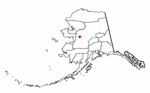
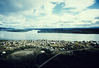
Koyukuk is a city in Yukon-Koyukuk Census Area, Alaska, United States. At the 2010 census the population was 96, down from 101 in 2000.

<span class="mw-page-title-main">Nenana, Alaska</span> City in Alaska, United States

Nenana (Lower Tanana: Toghotili; is a home rule city in the Yukon-Koyukuk Census Area of the Unorganized Borough in the Interior of the U.S. state of Alaska. Nenana developed as a Lower Tanana community at the confluence where the tributary Nenana River enters the Tanana. The population was 378 at the 2010 census, down from 402 in 2000.

References

  1. 1996 Alaska Municipal Officials Directory. Juneau: Alaska Municipal League/Alaska Department of Community and Regional Affairs. January 1996. p. 20. (though an earlier source states November 5, 1973; see "Directory of Borough and City Officials 1974". Alaska Local Government. XIII (2). Juneau: Alaska Department of Community and Regional Affairs: 14. January 1974.)
  2. 2023 Alaska Municipal Officials Directory (PDF). Juneau: Alaska Municipal League. January 2023. p. 38. Retrieved November 12, 2023.
  3. "2020 U.S. Gazetteer Files". United States Census Bureau. Retrieved October 29, 2021.
  4. "Alakanuk city, Alaska". United States Census Bureau . Retrieved September 7, 2023.
  5. "US Gazetteer files: 2010, 2000, and 1990". United States Census Bureau. February 12, 2011. Retrieved April 23, 2011.
  6. "Census of Population and Housing". Census.gov. Retrieved June 4, 2015.
  7. "Alaska - Number of Inhabitants" (PDF). United States Census Bureau. 1940.
  8. "Number of Inhabitants - Alaska" (PDF). United States Census Bureau. 1950.
  9. U.S. Census Bureau (June 2012). "2010 Census of Population and Housing - Alaska" (PDF). U.S. Government Printing Office. Archived from the original (PDF) on February 24, 2014.
  10. "U.S. Census website". United States Census Bureau . Retrieved January 31, 2008.
  11. "Schedule of Local Option Communities" (PDF). Alcoholic Beverage Control Board. Retrieved May 3, 2023.