List of boroughs and census areas in Alaska

Last updated

Boroughs and census areas of Alaska
Alaska boroughs and census areas.svg
Borough • City-borough • Census areas of the Unorganized Borough
LocationState of Alaska
Number19 organized boroughs
11 census areas
Populations(Organized boroughs): 687 (Yakutat) – 286,075 (Anchorage)
(Census areas): 2,262 (Hoonah-Angoon) – 18,224 (Bethel)
Areas(Organized boroughs): 434 square miles (1,120 km2) (Skagway) – 88,824 square miles (230,050 km2) (North Slope)
(Census areas): 4,393 square miles (11,380 km2) (Aleutians West) – 145,576 square miles (377,040 km2) (Yukon-Koyukuk)
Government
Subdivisions

The U.S. state of Alaska is divided into 19 organized boroughs and 1 unorganized borough. Alaska and the state of Louisiana are the only states that do not call their first-order administrative subdivisions counties (Louisiana uses parishes instead). [1] Delegates to the Alaska Constitutional Convention wanted to avoid the traditional county system and adopted their own unique model with different classes of boroughs varying in powers and duties. [2]

Contents

Many of the most densely populated regions of the state are part of Alaska's boroughs, which function similarly to counties in other states. There are four different classifications of organized boroughs: "Unified Home Rule" or "Non-unified Home Rule" (may exercise all legislative powers not prohibited by law or charter); "First Class" (may exercise any power not prohibited by law on a non-area wide basis by adopting ordinances); and "Second Class" (must gain voter approval for authority to exercise many non-area wide powers). [3]

However, unlike county-equivalents in the other 49 states, the organized boroughs do not cover the entire land area of the state. The area not part of any organized borough is referred to as the Unorganized Borough. The U.S. Census Bureau, in cooperation with the state, divides the Unorganized Borough into 11 census areas, each roughly corresponding to an election district, thus totaling 30 county equivalents. However, these areas exist solely for the purposes of statistical analysis and presentation; they have no government of their own. Boroughs and census areas are both treated as county-level equivalents by the Census Bureau.

Some areas in the Unorganized Borough receive limited public services directly from the Alaska state government, usually law enforcement from the Alaska State Troopers and educational funding.

Seven consolidated city-borough governments exist Juneau City and Borough, Skagway Municipality, Sitka City and Borough, Yakutat City and Borough, Wrangell City and Borough, Haines Borough, as well as the state's largest city, Anchorage. Though its legal name is the Municipality of Anchorage, it is considered a consolidated city-borough under state law.

The Federal Information Processing Standard (FIPS) 55-2,3,4 codes, which are used by the United States Census Bureau to uniquely identify states and counties, is provided with each entry. [4] Alaska's code is 02, so each code is of the format 02XXX. The FIPS code for each county equivalent links to census data for that county equivalent. There are 30 divisions in Alaska.

List of boroughs

Borough
FIPS code [5] Borough seat [6] Class
[7] [8] [9]
Est. [6] OriginEtymologyDensity
Population [10] Area [11] Map
Aleutians EastBorough 013 Sand Point Second1987-Its location in the east Aleutian Islands, which are themselves of uncertain linguistic origin; possibly derived from Chukchi word aliat ("island")0.503,4616,985 sq mi
(18,091 km2)
Map of Alaska highlighting Aleutians East Borough.svg
Anchorage 020 ( Consolidated
city-borough
)
Unified Home Rule1964/1975Anchorage Borough formed in 1964, merged with city in 1975 to form unified city-boroughDerived from the presence of a safe place to anchor and unload supplies for construction of the Alaska Railroad c.1913, thereby creating a community.167.59286,0751,707 sq mi
(4,421 km2)
Map of Alaska highlighting Anchorage Municipality.svg
Bristol BayBorough 060 Naknek Second1962-Named in 1778 by Capt. James Cook for George Digby, 2nd Earl of Bristol.1.75844482 sq mi
(1,248 km2)
Map of Alaska highlighting Bristol Bay Borough.svg
DenaliBorough 068 Healy Home Rule1990-From Denali, the tallest North American mountain, which means "great one" in the Dena'ina language 0.131,58412,641 sq mi
(32,740 km2)
Map of Alaska highlighting Denali Borough.svg
Fairbanks North StarBorough 090 Fairbanks Second1964-Named for its borough seat of Fairbanks, named in turn for Charles Fairbanks (1852–1918), U.S. Senator from Indiana and vice president under Theodore Roosevelt, and for Polaris, the North Star12.9394,8407,335 sq mi
(18,998 km2)
Map of Alaska highlighting Fairbanks North Star Borough.svg
HainesBorough 100 ( Consolidated
city-borough
)
Home Rule1968
(Consolidated 2002)
-After Haines, which was itself named for Mrs. Francina E. Haines (1819–1870), the key fundraiser for the construction of a Presbyterian mission in the town.0.882,0702,343 sq mi
(6,068 km2)
Map of Alaska highlighting Haines Borough.svg
Juneau 110 ( Consolidated
city-borough
)
Unified Home Rule1970The cities of Juneau and Douglas merged with the surrounding borough to form the municipality Joseph "Joe" Juneau (1836-1899), prospector and co-founder of the city.11.6731,5552,704 sq mi
(7,003 km2)
Map of Alaska highlighting Juneau City and Borough.svg
Kenai PeninsulaBorough 122 Soldotna Second1964-The Kenai Peninsula, whose name may be derived from Kenayskaya, the Russian name for Cook Inlet.3.8261,22316,017 sq mi
(41,484 km2)
Map of Alaska highlighting Kenai Peninsula Borough.svg
Ketchikan GatewayBorough 130 Ketchikan Second1963-The borough seat of Ketchikan and the borough's gateway location on the Alaska-Canada border.2.8313,7384,857 sq mi
(12,580 km2)
Map of Alaska highlighting Ketchikan Gateway Borough.svg
Kodiak IslandBorough 150 Kodiak Second1963-Named after Kodiak Island, which may itself be named for the Koniag people1.8812,5656,689 sq mi
(17,324 km2)
Map of Alaska highlighting Kodiak Island Borough.svg
Lake and PeninsulaBorough 164 King Salmon Home Rule1989-The borough's many large lakes, and the Alaska Peninsula 0.061,33123,832 sq mi
(61,725 km2)
Map of Alaska highlighting Lake and Peninsula Borough.svg
Matanuska-SusitnaBorough 170 Palmer Second1964-Named for the valley that the Matanuska and Susitna Rivers form.4.66115,23924,707 sq mi
(63,991 km2)
Map of Alaska highlighting Matanuska-Susitna Borough.svg
North SlopeBorough 185 Utqiaġvik Home Rule1972-The Alaska North Slope along the Brooks Range.0.1210,60388,824 sq mi
(230,053 km2)
Map of Alaska highlighting North Slope Borough.svg
Northwest ArcticBorough 188 Kotzebue Home Rule1986In 1986, residents of Kotzebue and 10 other area villages voted to form the Northwest Arctic Borough (with boundaries coincident with those of NANA), to be economically based on taxing the Red Dog mine, then under development.Its geographic location and position above the Arctic Circle.0.217,36135,663 sq mi
(92,367 km2)
Map of Alaska highlighting Northwest Arctic Borough.svg
PetersburgBorough 195 Petersburg Home Rule2013Incorporated after voters approved borough formation in December 2012.Named for Norwegian immigrant Peter Buschmann (1849-1903), founder of the former city of Petersburg.1.183,4272,901 sq mi
(7,514 km2)
Map of Alaska highlighting Petersburg Census Area.svg
Sitka 220 ( Consolidated
city-borough
)
Unified Home Rule1971-Derived from Tlingit word Shee At'iká, meaning "People on the outside of Shee (Baranof Island)."2.898,2822,870 sq mi
(7,433 km2)
Map of Alaska highlighting Sitka City and Borough.svg
Skagway 230 ( Consolidated
city-borough
)
First2007-Derived from Tlingit word Shgagwèi, meaning "a windy place with white caps on the water."2.521,095434 sq mi
(1,124 km2)
Map of Alaska highlighting Skagway City and Borough.svg
UnorganizedBorough ---1961The Borough Act of 1961 created The Unorganized Borough including all of Alaska not within a Unified, Home rule, First class or Second class borough.A legal entity in Alaska, covering those parts of Alaska not within an incorporated borough; it is directly administered by the State of Alaska. [12] 0.2475,362319,852 sq mi
(828,413 km2)
Map of Alaska highlighting the Unorganized Borough.svg
Wrangell 275 ( Consolidated
city-borough
)
Unified Home Rule2008Formerly part of Wrangell-Petersburg Census Area Ferdinand von Wrangel, Russian administrator of Alaska, 1840-49.0.812,0642,556 sq mi
(6,620 km2)
Map of Alaska highlighting Wrangell City and Borough.svg
Yakutat 282 ( Consolidated
city-borough
)
Home Rule1992- Yakutat Bay and the Yakutat Alaska Native people0.096877,623 sq mi
(19,743 km2)
Map of Alaska highlighting Yakutat City and Borough.svg

Census areas in the Unorganized Borough

Map of Alaska highlighting the Unorganized Borough Map of Alaska highlighting the Unorganized Borough.svg
Map of Alaska highlighting the Unorganized Borough

The Unorganized Borough is the portion of the U.S. state of Alaska not contained in any of its 19 organized boroughs. While referred to as the "Unorganized Borough", it is not a borough itself. It encompasses over half of Alaska's area, 970,500 km2. If the unorganized Borough were a state in itself, it would be the largest state in the United States of America, larger than the rest of Alaska and larger than Texas or California. (374,712 mi2). As of the 2023 Census estimate, 10% of Alaskans (75,362 people) reside in it.

Currently unique among the United States, Alaska is not entirely subdivided into organized county equivalents. For the 1980 census, the United States Census Bureau divided the unorganized borough into 12 census areas to facilitate census taking in the vast unorganized area. As new boroughs incorporate, these areas have been altered or eliminated to accommodate, [13] such that there are currently 11 census areas:

Census area
FIPS code [5] Largest town
(as of 2000)
EtymologyDensity
Population [10] Area [11] Map
Aleutians WestCensus Area 016 Unalaska Location in the western Aleutian Islands.1.175,1604,393 sq mi
(11,378 km2)
Map of Alaska highlighting Aleutians West Census Area.svg
BethelCensus Area 050 Bethel City of Bethel, the largest settlement in the census area, which is itself named for the Biblical term Bethel ("house of God").0.4518,22440,627 sq mi
(105,223 km2)
Map of Alaska highlighting Bethel Census Area.svg
ChugachCensus Area 063 Valdez The Chugach people
(Part of Valdez–Cordova Census Area prior to January 02, 2019) [14] [15]
0.716,7699,530 sq mi
(24,683 km2)
Map of Alaska highlighting Chugach Census Area.svg
Copper RiverCensus Area 066 Glennallen The Copper River
(Part of Valdez–Cordova Census Area prior to January 02, 2019) [14] [15]
0.112,67424,692 sq mi
(63,952 km2)
Map of Alaska highlighting Copper River Census Area.svg
DillinghamCensus Area 070 Dillingham The city of Dillingham, the largest settlement in the area, which was itself named after United States Senator Paul Dillingham (1843–1923), who had toured Alaska extensively with his Senate subcommittee in 1903.0.254,60718,334 sq mi
(47,485 km2)
Map of Alaska highlighting Dillingham Census Area.svg
Hoonah–AngoonCensus Area 105 Hoonah The cities of Hoonah and Angoon 0.352,2626,555 sq mi
(16,977 km2)
Map of Alaska highlighting Hoonah-Angoon Census Area.svg
KusilvakCensus Area 158 Hooper Bay Kusilvak Mountains
(Known as Wade Hampton prior to 2015)
0.478,00117,077 sq mi
(44,229 km2)
Map of Alaska highlighting Kusilvak Census Area.svg
NomeCensus Area 180 Nome City of Nome, the largest settlement in the census area.0.439,76322,969 sq mi
(59,489 km2)
Map of Alaska highlighting Nome Census Area.svg
Prince of Wales-HyderCensus Area 198 Craig Prince of Wales Island and the town of Hyder
(Known as Prince of Wales-Outer Ketchikan prior to the expansion of Ketchikan Gateway Borough in 2008)
1.085,6965,268 sq mi
(13,644 km2)
Map of Alaska highlighting Prince of Wales-Hyder Census Area.svg
Southeast FairbanksCensus Area 240 Deltana Its location, southeast of Fairbanks 0.297,07724,831 sq mi
(64,312 km2)
Map of Alaska highlighting Southeast Fairbanks Census Area.svg
Yukon-KoyukukCensus Area 290 Fort Yukon Yukon River ("great river" in Gwich’in), which flows through the census area; and the city of Koyukuk 0.045,129145,576 sq mi
(377,040 km2)
Map of Alaska highlighting Yukon-Koyukuk Census Area.svg

See also

Related Research Articles

<span class="mw-page-title-main">Aleutians West Census Area, Alaska</span> Census area in Alaska, United States

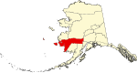
Aleutians West Census Area is a census area located in the U.S. state of Alaska. As of the 2020 census, the population was 5,232, down from 5,561 in 2010.

<span class="mw-page-title-main">Lake and Peninsula Borough, Alaska</span> Borough in Alaska, United States

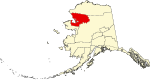
Lake and Peninsula Borough is a borough in the state of Alaska. As of the 2020 census, the population was 1,476, down from 1,631 in 2010. The borough seat of King Salmon is located in neighboring Bristol Bay Borough, although is not the seat of that borough. The most populous community in the borough is the census-designated place of Port Alsworth. With an average of 0.017 inhabitants per square kilometre, the Lake and Peninsula Borough is the second least densely populated organized county-equivalent in the United States; only the unorganized Yukon-Koyukuk Census Area has a lower density.

<span class="mw-page-title-main">Prince of Wales–Hyder Census Area, Alaska</span> Census area in Alaska, United States

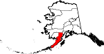
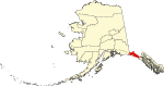
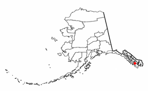
Prince of Wales–Hyder Census Area is a census area located in the U.S. state of Alaska. As of the 2020 census, the population was 5,753, up from 5,559 in 2010. It is part of the unorganized borough and therefore has no borough seat. Its largest communities are Metlakatla and Craig. It was formerly part of the Census Bureau's Prince of Wales–Outer Ketchikan Census Area, but the name was changed in 2008 after most of the Outer Ketchikan was lost to annexation by the Ketchikan Gateway Borough.

<span class="mw-page-title-main">Yakutat, Alaska</span> Consolidated city-borough in Alaska, United States

The City and Borough of Yakutat is a borough in the state of Alaska. Yakutat was also the name of a former city within the borough. The name in Tlingit is Yaakwdáat. It is derived from an Eyak name, diyaʼqudaʼt, and was influenced by the Tlingit word yaakw.

<span class="mw-page-title-main">County (United States)</span> Subdivision used by most states in the United States

In the United States, a county or county equivalent is an administrative or political subdivision of a U.S. state or other territories of the United States which consists of a geographic area with specific boundaries and usually some level of governmental authority. The term "county" is used in 48 states, while Louisiana and Alaska have functionally equivalent subdivisions called parishes and boroughs, respectively. The specific governmental powers of counties vary widely between the states, with many providing some level of services to civil townships, municipalities, and unincorporated areas. Certain municipalities are in multiple counties; New York City is uniquely partitioned into five counties, referred to at the city government level as boroughs. Some municipalities have been consolidated with their county government to form consolidated city-counties, or have been legally separated from counties altogether to form independent cities. Conversely, those counties in Connecticut, Rhode Island, eight of Massachusetts's 14 counties, and Alaska's Unorganized Borough have no government power, existing only as geographic distinctions.

<span class="mw-page-title-main">Atqasuk, Alaska</span> City in Alaska, United States

Atqasuk is a city in North Slope Borough, Alaska, United States. The population was 276 at the 2020 census and 233 as of the 2010 census.

<span class="mw-page-title-main">Wainwright, Alaska</span> City in Alaska, United States

Wainwright, also known as Ulguniq or Kuuk, is a city in North Slope Borough, Alaska, United States. At the 2020 census the population was 628, making it the third largest city in the North Slope Borough, up from 556 in 2010. The community was named after Wainwright Lagoon, which in turn was named after Lt. John Wainwright, an officer under Capt. F. W. Beechey, who were the first non-native people to travel to the lagoon in 1826. An unincorporated area known as Wainwright Inlet by 1890, Wainwright was founded as an incorporated municipality in 1904.

<span class="mw-page-title-main">Craig, Alaska</span> Town in Alaska

Craig is a city in the Prince of Wales-Hyder Census Area in the Unorganized Borough in the U.S. state of Alaska. The population was 1,036 at the 2020 census, down from 1,201 in 2010.

<span class="mw-page-title-main">Naukati Bay, Alaska</span> Census-designated place in Alaska, United States

Naukati Bay is a census-designated place (CDP) in the Prince of Wales-Hyder Census Area of the Unorganized Borough of the U.S. state of Alaska. The population was 113 at the 2010 census, down from 135 in 2000.

A minor civil division (MCD) is a term used by the United States Census Bureau for primary governmental and/or administrative divisions of a county or county-equivalent, typically a municipal government such as a city, town, or civil township. MCDs are used for statistical purposes by the Census Bureau, and do not necessarily represent the primary form of local government. They range from non-governing geographical survey areas to municipalities with weak or strong powers of self-government. Some states with large unincorporated areas give substantial powers to counties; others have smaller or larger incorporated entities with governmental powers that are smaller than the MCD level chosen by the Census.

In 45 of the 50 states of the United States, the county is used for the level of local government immediately below the state itself. Louisiana uses parishes, and Alaska uses boroughs. In Connecticut, Massachusetts, and Rhode Island, some or all counties within states have no governments of their own; the counties continue to exist as legal entities, however, and are used by states for some administrative functions and by the United States Census bureau for statistical analysis. There are 3,242 counties and county equivalent administrative units in total, including the District of Columbia and 100 county-equivalents in the U.S. territories.

<span class="mw-page-title-main">Local government in the United States</span> Governmental jurisdictions below the level of the state

Most U.S. states and territories have at least two tiers of local government: counties and municipalities. Louisiana uses the term parish and Alaska uses the term borough for what the U.S. Census Bureau terms county equivalents in those states. Civil townships or towns are used as subdivisions of a county in 20 states, mostly in the Northeast and Midwest.

<span class="mw-page-title-main">Unorganized Borough, Alaska</span> Portions of Alaska which are not contained in any of its 19 other organized boroughs

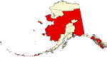
The Unorganized Borough is composed of the portions of the U.S. state of Alaska which are not contained in any of its 19 organized boroughs. While referred to as the "Unorganized Borough", it is not a borough itself, as it forgoes that level of government structure. It encompasses nearly half of Alaska's land area, 323,440 square miles (837,700 km2), and, as of the 2020 U.S. Census, it had a population of 77,157, which was 10.52% of the population of the state. The largest communities in the Unorganized Borough are the cities of Bethel, Unalaska, and Valdez.

<span class="mw-page-title-main">Government of Alaska</span> State government of the U.S. State of Alaska

The government of Alaska in common with state and federal governments of the United States, has three branches of government: the executive, consisting of the Governor of Alaska and the state agencies; the state legislature consisting of two chambers, the House of Representatives and the Senate; and the judiciary consisting of the Supreme court and lower courts.

In the United States, an independent city is a city that is not in the territory of any county or counties and is considered a primary administrative division of its state. Independent cities are classified by the United States Census Bureau as "county equivalents" and may also have similar governmental powers to a consolidated city-county or a unitary authority. However, in the case of a consolidated city-county, a city and a county were merged into a unified jurisdiction in which the county at least nominally exists to this day, whereas an independent city was legally separated from any county or merged with a county that simultaneously ceased to exist even in name.

The administrative divisions of Alaska are the various units of government that provide local government services in the state of Alaska.

References

  1. "Alaska Population Estimates". Alaska Department of Labor and Workforce Development. Archived from the original on March 27, 2020. Retrieved March 1, 2020.
  2. "Local Government". Alaska Humanities Forum. Archived from the original on November 5, 2021. Retrieved November 4, 2021.
  3. "Alaska Local Government Primer" (PDF), Alaska Municipal League, archived (PDF) from the original on September 8, 2023, retrieved September 8, 2023
  4. "FIPS Publish 6-4". National Institute of Standards and Technology. Archived from the original on September 29, 2013. Retrieved April 11, 2007.
  5. 1 2 "EPA County FIPS Code Listing". EPA.gov. Archived from the original on March 13, 2011. Retrieved February 23, 2008.
  6. 1 2 "Find A County". National Association of Counties. Archived from the original on April 16, 2013. Retrieved April 7, 2012.
  7. "Municipal Certificates". Local Boundary Commission, Division of Community and Regional Affairs, Alaska Department of Commerce, Community and Economic Development. Archived from the original on January 6, 2018. Retrieved January 5, 2018.
  8. "Alaska Taxable 2004 Municipal Taxation - Rates and Policies" (PDF). Division of Community and Regional Affairs, Alaska Department of Commerce, Community and Economic Development. January 2005. Archived from the original (PDF) on September 9, 2008. Retrieved July 16, 2008.
  9. "Background on Boroughs in Alaska" (PDF). Local Boundary Commission, Division of Community and Regional Affairs, Alaska Department of Commerce, Community and Economic Development. November 2000. Archived (PDF) from the original on October 9, 2022. Retrieved July 16, 2008.
  10. 1 2 "U.S. Census Bureau QuickFacts: Alaska". Archived from the original on September 28, 2021. Retrieved March 20, 2024.
  11. 1 2 "TIGERweb". US Census. Archived from the original on November 3, 2012. Retrieved March 1, 2020.
  12. "Governmental Unit Boundary Data Content Standard (Working Draft, Version 2.0)" (PDF). Subcommittee on Cultural and Demographic Data, Federal Geographic Data Committee, United States Census Bureau, United States Department of Commerce. February 1999. Archived (PDF) from the original on October 9, 2022. Retrieved July 16, 2008.
  13. "Substantial Changes to Counties and County Equivalent Entities: 1970-Present". United States Census Bureau. Archived from the original on March 12, 2019. Retrieved September 2, 2014.
  14. 1 2 "Changes to Counties and County Equivalent Entities: 1970-Present". The United States Census Bureau. Archived from the original on April 28, 2021. Retrieved February 29, 2020.
  15. 1 2 "Alaska Population Estimates". Alaska Department of Labor and Workforce Development. Archived from the original on March 27, 2020. Retrieved March 1, 2020.

Other sources