Place (United States Census Bureau)

Last updated

The United States Census Bureau defines a place as a concentration of population which has a name, is locally recognized, and is not part of any other place. A place typically has a residential nucleus and a closely spaced street pattern, and it frequently includes commercial property and other urban land uses. A place may be an incorporated place (a self-governing city, town, or village) or it may be a census-designated place (CDP). Incorporated places are defined by the laws of the states in which they are contained. The Census Bureau delineates CDPs. A small settlement in the open countryside or the densely settled fringe of a large city may not be a place as defined by the Census Bureau. As of the census, 26% of the people in the United States lived outside of places. [1]

Contents

Incorporated place

An incorporated place, under the Census Bureau's definition, [2] is a type of governmental unit incorporated under state law as a city, town (except in the New England states, New York, and Wisconsin), [3] borough (except in Alaska and New York), [4] or village, and having legally prescribed limits, powers, and functions. Requirements for incorporation vary widely among the states; some states have few specific criteria, while others have established population thresholds and occasionally other conditions (for example, minimum land area, population density, and distance from other existing incorporated places) that must be met for incorporation. [1]

The Census Bureau recognizes incorporated places in all U.S. states except Hawaii; for Hawaii, by agreement with the Office of the Governor, the Census Bureau recognizes all places as census-designated places (CDPs) rather than as incorporated places. Puerto Rico and several of the outlying areas under United States jurisdiction (such as Guam and the Northern Mariana Islands) also have no incorporated places. [1]

Different states use a variety of terms for their incorporated places. The designations "city", "town", "village", and "borough" are most frequent, but one or more places in Kentucky, Montana, Nevada, and Tennessee have place-type governments (usually consolidated ones) that do not have any of these designations. New Jersey is the only state that uses all four terms for types of incorporated places. Only two other states (Connecticut and Pennsylvania) include "boroughs" as incorporated places. Eleven U.S. states have only "cities", and the remainder of the states have various combinations of "cities", "towns", and "villages". [1]

Not all entities designated as "towns" and "boroughs" are considered by the Census Bureau to be places. In the six New England states, and in New York and Wisconsin, the term "town" refers to what the Census Bureau classifies as a minor civil division (MCD) rather than a place. The MCDs in these states, while often functioning with all the powers of city governments, can contain considerable rural area; outside of New England, other units of government perform the incorporated place function. In Alaska, the term "borough" refers to territory governed as a county rather than as a place; in New York, the Census Bureau treats the five boroughs that make up New York City as MCDs. [1]

Census-designated places

Census-designated places (CDPs) are communities that lack separate municipal governments, and for statistical purposes are defined by the Census Bureau in order to statistically combine and compare populated areas that physically resemble incorporated places. Before each decennial census, CDPs are delineated by state and local agencies, and by tribal officials according to Census Bureau criteria. The resulting CDP delineations are then reviewed and approved by the Census Bureau. The boundaries of a CDP have no legal status and may not correspond with the local understanding of the area with the same name. Recognized communities may be divided into two or more CDPs while on the other hand, two or more communities may be combined into one CDP. A CDP may also cover the unincorporated part of a named community where the rest lies within an incorporated place. [1]

Although only about one-fifth as numerous as incorporated places (in 1990, of 23,435 "places", 19,289 were incorporated municipalities, and 4,146 were not incorporated municipalities), CDPs are important geographic units. The CDP permits the tabulation of population counts for many localities that otherwise would have no identity within the Census Bureau's framework of geographic areas. By defining an area as a CDP, that locality then appears in the same category of census data as incorporated places. This distinguishes CDPs from other census classifications, such as minor civil divisions (MCDs), which are in a separate category. In 1990, over 29 million people in the United States resided in CDPs. [1]

Specific examples

Outside the U.S.

Statistics Canada uses the term designated place (DPL) for unincorporated population centers. However, the criteria for delineating a DPL are different from that for a CDP. [5]

Geography

The Census Bureau lists a location (latitude and longitude) for each place, although this list is not intended for general use and is part of the Bureau's TIGER mapping system to graphically represent the statistical areas used in census data. The Census Bureau's criteria for establishing the location does not correspond to the criteria used by the United States Geological Survey (USGS) for locating named communities, which is intended to be an authoritative reference for a place's location. The central location of a place shown on Census Bureau maps for a community may differ significantly from that on USGS maps for the same place and may even be outside the area that local residents think of as that community. The Census Bureau's location of a place is the approximate geographic center of the polygon making up the boundaries of the place at the time of the decennial census. [6] The USGS location of a populated place is the center of the original place, if known, such as the city or town hall, main post office, town square or main intersection regardless of changes over time. [7] [8] [9]

Notes

  1. 1 2 3 4 5 6 7 "Geographic Areas Reference Manual". United States Census Bureau. Chapter 9. Archived from the original on Mar 13, 2019.
  2. "Incorporated place". Geography Program. U.S. Census Bureau. Retrieved 22 April 2020.
  3. Towns in the New England states are governmental units on the same level as cities, but are not treated as such by the Census Bureau. In Wisconsin, towns are similar to the civil townships of other states. In New York, towns have a status intermediate between those of Wisconsin and New England.
  4. Boroughs in Alaska are analogous to counties in other states. Boroughs in New York are simultaneously counties and administrative divisions of New York City.
  5. "Designated Place (DPL)". statcan.ca. Archived from the original on Jun 1, 2008.
  6. "Q19: How did you calculate the latitude and longitude for my town since your information puts it at a point that is actually outside of town?". United States Census Bureau. Archived from the original on May 6, 2009.
  7. "Geographic Names Information System (GNIS): Domestic Names - Metadata". U.S. Geological Survey. 2009-08-18. Archived from the original on 2012-02-06. Retrieved 2023-07-30. Primary Point: The official feature location is a single point to which the official feature name is associated in order to ensure positive and unique identification and association, also referred to as the primary point. The location is determined by the authoritative source and is approved or recognized as official by the U.S. Board on Geographic Names by decision or by policy delegation to the authoritative source. The placing of the location point is governed by policies of the Board as defined in the Names Data Users Guide and GNIS metadata, generally at or near the geographic center, but there are exceptions for certain classes of features.
  8. "Domestic Names - Frequently Asked Questions (FAQs) #17". U.S. Geological Survey. 2014-10-17. Archived from the original on 2015-03-08. Retrieved 2023-07-30. Question 17: In the GNIS database, the Primary coordinate values for communities are taken at the center of the "original" community meaning the city hall, main post office, main intersection, etc.
  9. "GNIS States, Territories, Associated Areas of the United States Text Format for National tabular digital data". U.S. Geological Survey. 2017. Archived from the original on 2023-07-30. Retrieved 2023-07-30. Primary Point: The official feature location is a single point to which the official feature name is associated in order to ensure positive and unique identification and association, also referred to as the primary point. The location is determined by the authoritative source and is approved or recognized as official by the U.S. Board on Geographic Names by decision or by policy delegation to the authoritative source. The placing of the location point is governed by policies of the Board as defined in the Names Data Users Guide and GNIS metadata, generally at or near the geographic center, but there are exceptions for certain classes of features. For example, the official feature location of flowing bodies of water (streams, rivers, creeks, etc.) or trending linear features (valleys, gulchs, gullys, hollows, etc.) is at the mouth. A geographic feature may have only one official location regardless of size, extent, composition, structure, or boundaries. The location point is coincident with, but in addition to and independent of, any other geospatial representation or boundary definition that may be attached to the feature in other datasets. Linear and aerial features may have secondary points as defined in the Names Data Users Guide and GNIS metadata. Locations are stored in the Geographic Names Information System as latitude and longitude in decimal degrees to seven places.

Related Research Articles

<span class="mw-page-title-main">Bostonia, California</span> Neighborhood in San Diego, California, United States

Bostonia is a neighborhood in San Diego County, California, comprising part of the northeastern portion of the city of El Cajon, as well as adjacent unincorporated areas of San Diego County such as Grossmont and Santee. The portion of Bostonia that lies outside the El Cajon city limits is classified as a census-designated place (CDP) for statistical purposes by the United States Census Bureau. The population of the CDP was 15,379 at the 2010 census, up from 15,169 at the 2000 census.

<span class="mw-page-title-main">Unincorporated area</span> Region of land not governed by own local government

An unincorporated area is a region that is not governed by a local municipal corporation. Widespread unincorporated communities and areas are a feature of the United States and Canada. Most other countries of the world either have no unincorporated areas at all or these are very rare.

A census-designated place (CDP) is a concentration of population defined by the United States Census Bureau for statistical purposes only.

A minor civil division (MCD) is a term used by the United States Census Bureau for primary governmental and/or administrative divisions of a county or county-equivalent, typically a municipal government such as a city, town, or civil township. MCDs are used for statistical purposes by the Census Bureau, and do not necessarily represent the primary form of local government. They range from non-governing geographical survey areas to municipalities with weak or strong powers of self-government. Some states with large unincorporated areas give substantial powers to counties; others have smaller or larger incorporated entities with governmental powers that are smaller than the MCD level chosen by the Census.

<span class="mw-page-title-main">Geographic Names Information System</span> Geographical database

The Geographic Names Information System (GNIS) is a database of name and location information about more than two million physical and cultural features throughout the United States and its territories, Antarctica, and the associated states of the Marshall Islands, Federated States of Micronesia, and Palau. It is a type of gazetteer. It was developed by the United States Geological Survey (USGS) in cooperation with the United States Board on Geographic Names (BGN) to promote the standardization of feature names.

<span class="mw-page-title-main">Administrative divisions of New York (state)</span> Administrative divisions of New York State

The administrative divisions of New York are the various units of government that provide local services in the U.S. State of New York. The state is divided into boroughs, counties, cities, towns, and villages. They are municipal corporations, chartered (created) by the New York State Legislature, as under the New York State Constitution the only body that can create governmental units is the state. All of them have their own governments, sometimes with no paid employees, that provide local services. Centers of population that are not incorporated and have no government or local services are designated hamlets. Whether a municipality is defined as a borough, city, town, or village is determined not by population or land area, but rather on the form of government selected by the residents and approved by the New York State Legislature. Each type of local government is granted specific home rule powers by the New York State Constitution. There are still occasional changes as a village becomes a city, or a village dissolves, each of which requires legislative action. New York also has various corporate entities that provide local services and have their own administrative structures (governments), such as school and fire districts. These are not found in all counties.

<span class="mw-page-title-main">Whittier, North Carolina</span> Census-designated place in North Carolina, United States

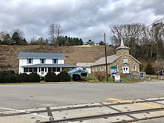
Whittier is an unincorporated community and census-designated place (CDP) in Jackson and Swain counties in the western part of the U.S. state of North Carolina. It was first listed as a CDP in the 2020 census with a population of 6,990.

<span class="mw-page-title-main">New England town</span> Basic unit of local government in the six New England states of the United States

The town is the basic unit of local government and local division of state authority in the six New England states. Most other U.S. states lack a direct counterpart to the New England town. New England towns overlay the entire area of a state, similar to civil townships in other states where they exist, but they are fully functioning municipal corporations, possessing powers similar to cities and counties in other states. New Jersey's system of equally powerful townships, boroughs, towns, and cities is the system which is most similar to that of New England. New England towns are often governed by a town meeting legislative body. The great majority of municipal corporations in New England are based on the town model; there, statutory forms based on the concept of a compact populated place are uncommon, though elsewhere in the U.S. they are prevalent. County government in New England states is typically weak at best, and in some states nonexistent. Connecticut, for example, has no county governments, nor does Rhode Island. Both of those states retain counties only as geographic subdivisions with no governmental authority, while Massachusetts has abolished eight of fourteen county governments so far. Counties serve mostly as dividing lines for the states' judicial systems and some other state services in the southern New England states, while providing varying services in the more sparsely populated three northern New England states.

<span class="mw-page-title-main">Census county division</span> U.S. statistical division of unincorporated areas of counties

A Census County Division (CCD) is a subdivision of a county used by the United States Census Bureau for the purpose of presenting statistical data. A CCD is a relatively permanent statistical area delineated cooperatively by the Census Bureau and state and local government authorities. CCDs are defined in 21 states that do not have well-defined and stable minor civil divisions (MCDs), such as townships, with local governmental purposes, or where the MCDs are deemed to be "unsatisfactory for the collection, presentation, and analysis of census statistics".

<span class="mw-page-title-main">Watkins, Colorado</span> Census Designated Place in Colorado, United States

Watkins is an unincorporated town and a census-designated place (CDP) located in and governed by Arapahoe and Adams counties, Colorado, United States. The CDP is a part of the Denver–Aurora–Lakewood, CO Metropolitan Statistical Area. The town is surrounded by Aurora and its post office, which lies within the Aurora city limits, has the ZIP Code 80137. At the United States Census 2020, the population of the Watkins CDP was 682.

<span class="mw-page-title-main">Human settlement</span> Community of any size, in which people live

In geography, statistics and archaeology, a settlement, locality or populated place is a community of people living in a particular place. The complexity of a settlement can range from a minuscule number of dwellings grouped together to the largest of cities with surrounding urbanized areas. Settlements may include hamlets, villages, towns and cities. A settlement may have known historical properties such as the date or era in which it was first settled, or first settled by particular people. The process of settlement envolves human migration

Connecticut shares with the five other New England states a governmental structure known as the New England town. From 1666 to 1960, Connecticut had a system of county governments, which each had limited powers given to it by the General Assembly. They were abolished by Public Act 152 in 1960. Connecticut also had a system of sheriffs' offices until October 2000, when those were also abolished.

A designated place (DPL) is a type of community or settlement identified by Statistics Canada that does not meet the criteria used to define municipalities or population centres. DPLs are delineated every 5 years for the Canadian census as the statistical counterparts of incorporated places such as cities, towns, and villages.

Sweetwater is an unincorporated community in Beaver Township, Buffalo County, Nebraska, United States. It lies along Nebraska Highway 2, half way between Ravenna and Hazard. It is a part of the Kearney, Nebraska Micropolitan Statistical Area. Sweetwater is located on Mud Creek, a tributary of the South Loup River.

This article includes information about the 100 most populous incorporated cities, the 100 most populous core-based statistical areas (CBSAs), and the 100 most populous primary statistical areas (PSAs) of the United States and Puerto Rico. This information is displayed in two tables. The first table ranks the cities, CBSAs, and PSAs separately by population. The second table displays the areas in hierarchical order by the most populous PSA, then most populous CBSA, and then most populous city.

<span class="mw-page-title-main">Four Square Mile, Colorado</span> Census Designated Place in Colorado, United States

Four Square Mile is an unincorporated community and a census-designated place (CDP) located in and governed by Arapahoe County, Colorado, United States. The population was 22,872 at the 2020 census. The CDP is a part of the Denver–Aurora–Lakewood, CO Metropolitan Statistical Area. The CDP is surrounded by Denver on the north, west, and south and by Aurora on the east. The name is derived from the four square miles bounded by Quebec Street, Mississippi Avenue, Havana Street and Yale Avenue. Annexation of the Arapahoe County enclave was contested between Denver and Aurora in the early 1970s, with Denver annexing east from Quebec Street and Aurora west from Havana Street. Denver’s annexations were ultimately stopped by the Poundstone Amendment; Aurora is not similarly limited but made its most recent annexation to Dayton Street in 1984, leaving nearly three of the four square miles unincorporated. The Four Square Mile CDP includes Sullivan, a previous unincorporated community designation. The area lies in ZIP codes 80231 and 80247.

References