Southeast Fairbanks Census Area, Alaska

Last updated

Southeast Fairbanks Census Area
Eagle Courthouse.JPG
Historic Courthouse in Eagle, Alaska.
Map of Alaska highlighting Southeast Fairbanks Census Area.svg
Location within the U.S. state of Alaska
Alaska in United States (US50).svg
Alaska's location within the U.S.
Coordinates: 63°46′N143°36′W / 63.77°N 143.6°W / 63.77; -143.6
CountryFlag of the United States.svg United States
StateFlag of Alaska.svg  Alaska
Established1980 [1]
Named for its location to the southeast of Fairbanks, Alaska
Largest CDP Deltana
Area
  Total25,059 sq mi (64,900 km2)
  Land24,769 sq mi (64,150 km2)
  Water291 sq mi (750 km2)  1.2%
Population
 (2020)
  Total7,021
  Density0.28/sq mi (0.11/km2)
Time zone UTC−9 (Alaska)
  Summer (DST) UTC−8 (ADT)
Congressional district At-large

Southeast Fairbanks Census Area is a census area located in the U.S. state of Alaska. As of the 2020 census, the population was 6,808, down from 7,029 in 2010. [2] [3] It is part of the unorganized borough and therefore has no borough seat. Its largest communities are Deltana and Tok, both unincorporated CDPs.

Contents

Geography

According to the U.S. Census Bureau, the census area has a total area of 25,059 square miles (64,900 km2), of which 24,769 square miles (64,150 km2) is land and 291 square miles (750 km2) (1.2%) is water. [4] For comparison, it is slightly bigger than the state of West Virginia.

Adjacent boroughs and census areas

National protected areas

Politics

Southeast Fairbanks is one of the most Republican parts of Alaska, frequently giving Republican candidates well over 70% of the vote. Southeast Fairbanks has consistently mirrored Alaska's overall electoral preferences, voting for the statewide winner in every presidential election since Alaska's statehood in 1960.

United States presidential election results for Southeast Fairbanks Census Area, Alaska [5]
Year Republican Democratic Third party
No.%No.%No.%
2020 2,82376.19%74820.19%1343.62%
2016 2,44171.10%66919.49%3239.41%
2012 2,24972.81%68022.01%1605.18%
2008 2,76679.80%70020.20%00.00%
2004 1,66877.01%41419.11%843.88%
2000 2,12873.71%47116.31%2889.98%
1996 1,53261.50%56322.60%39615.90%
1992 1,15843.91%52519.91%95436.18%
1988 1,52267.58%58826.11%1426.31%
1984 1,85577.10%45718.99%943.91%
1980 1,15859.08%37419.08%42821.84%
1976 80353.93%55837.47%1288.60%
1972 56259.28%27829.32%10811.39%
1968 45449.13%28731.06%18319.81%
1964 25832.74%53067.26%00.00%
1960 36555.14%29744.86%00.00%

Demographics

Historical population
CensusPop.Note
1970 4,179
1980 5,67635.8%
1990 5,9134.2%
2000 6,1744.4%
2010 7,02913.8%
2020 6,808−3.1%
2023 (est.)7,077 [6] 4.0%
U.S. Decennial Census [7]
1900–1990 [8] 1990–2000 [9]
2010–2020 [2] [3]

As of the census [10] of 2000, there were 6,174 people, 2,098 households, and 1,506 families living in the census area. The population density was 0.25 people per square mile (0.097 people/km2). There were 3,225 housing units at an average density of 0.13 per square mile (0.050/km2). The racial makeup of the census area was 78.99% White, 1.98% Black or African American, 12.71% Native American, 0.68% Asian, 0.15% Pacific Islander, 0.73% from other races, and 4.76% from two or more races. 2.70% of the population were Hispanic or Latino of any race. 4.29% reported speaking an Athabaskan language at home, while 4.02% speak Russian, 3.76% Ukrainian, and 2.34% Spanish. [11]

Of the 2,098 households, 39.40% had children under the age of 18 living with them, 58.20% were married couples living together, 8.60% had a female householder with no husband present, and 28.20% were non-families. 23.50% of households were one person, and 5.50% were one person aged 65 or older. The average household size was 2.80 and the average family size was 3.34.

In the census area, the population was spread out, with 32.80% under the age of 18, 7.60% from 18 to 24, 27.80% from 25 to 44, 25.70% from 45 to 64, and 6.10% 65 or older. The median age was 34 years. For every 100 females, there were 107.20 males. For every 100 females age 18 and over, there were 108.60 males.

2020 Census

Races (alone or in combination with other) in Southeast Fairbanks Census Area (2020 United States Census) [12]
RacePercentage of Population
White 82.70%
Black or African American 1.87%
American Indian or Alaska Native 16.64%
Asian 2.75%
Native Hawaiian and Other Pacific Islander 1.10%
Some other race4.48%

Communities

Cities

Census-designated places

See also

Related Research Articles

<span class="mw-page-title-main">Bethel Census Area, Alaska</span> Census area in Alaska, United States

Bethel Census Area is a census area in the U.S. state of Alaska. As of the 2020 census, the population is 18,666, up from 17,013 in 2010. It is part of the unorganized borough and therefore has no borough seat. Its largest community is the city of Bethel, which is also the largest city in the unorganized borough.

<span class="mw-page-title-main">Denali Borough, Alaska</span> Borough in Alaska, United States

The Denali Borough is a borough located in the U.S. state of Alaska. As of the 2020 census the population of the borough was 1,619, down from 1,826 in 2010. The borough seat and most populated community is Healy, and its only incorporated place is Anderson. The borough was incorporated in December 1990.

<span class="mw-page-title-main">Fairbanks North Star Borough, Alaska</span> Borough in Alaska, United States

The Fairbanks North Star Borough is a borough located in the U.S. state of Alaska. As of the 2020 census, the population was 95,665, down from 97,581 in 2010. The borough seat is Fairbanks. The borough's land area is slightly smaller than that of the state of New Jersey.

<span class="mw-page-title-main">Haines Borough, Alaska</span> Borough in Alaska, United States

Haines Borough is a home-rule borough located in the state of Alaska. As of the 2020 census, the population was 2,080, down from 2,508 in 2010.

<span class="mw-page-title-main">Ketchikan Gateway Borough, Alaska</span> Borough in Alaska, United States

Ketchikan Gateway Borough is a borough located in the U.S. state of Alaska. As of the 2020 census its population was 13,948, up from 13,477 in 2010. The borough seat is Ketchikan. The borough is the second most populous borough in Southeast Alaska, the first being Juneau Borough.

<span class="mw-page-title-main">Lake and Peninsula Borough, Alaska</span> Borough in Alaska, United States

Lake and Peninsula Borough is a borough in the state of Alaska. As of the 2020 census, the population was 1,476, down from 1,631 in 2010. The borough seat of King Salmon is located in neighboring Bristol Bay Borough, although is not the seat of that borough. The most populous community in the borough is the census-designated place of Port Alsworth. With an average of 0.017 inhabitants per square kilometre, the Lake and Peninsula Borough is the second least densely populated organized county-equivalent in the United States; only the unorganized Yukon-Koyukuk Census Area has a lower density.

<span class="mw-page-title-main">Matanuska-Susitna Borough, Alaska</span> Borough in Alaska, United States

Matanuska-Susitna Borough is a borough located in the U.S. state of Alaska. Its borough seat is Palmer, and the largest community is the census-designated place of Knik-Fairview. As of the 2020 census, the borough's population was 107,801.

<span class="mw-page-title-main">Nome Census Area, Alaska</span> Census area in Alaska, United States

Nome Census Area is a census area located in the U.S. state of Alaska, mostly overlapping with the Seward Peninsula. As of the 2020 census, the population was 10,046, up from 9,492 in 2010. It is part of the unorganized borough and therefore has no borough seat. Its largest community by far is the city of Nome.

<span class="mw-page-title-main">Prince of Wales–Hyder Census Area, Alaska</span> Census area in Alaska, United States

Prince of Wales–Hyder Census Area is a census area located in the U.S. state of Alaska. As of the 2020 census, the population was 5,753, up from 5,559 in 2010. It is part of the unorganized borough and therefore has no borough seat. Its largest communities are Metlakatla and Craig. It was formerly part of the Census Bureau's Prince of Wales–Outer Ketchikan Census Area, but the name was changed in 2008 after most of the Outer Ketchikan was lost to annexation by the Ketchikan Gateway Borough.

<span class="mw-page-title-main">Hoonah–Angoon Census Area, Alaska</span> Census area in Alaska, United States

Hoonah–Angoon Census Area is a census area located in the U.S. state of Alaska. As of the 2020 census, the population was 2,365, up from 2,150 in 2010. It is part of the unorganized borough and therefore has no borough seat. Its largest community is the city of Hoonah.

<span class="mw-page-title-main">Valdez–Cordova Census Area, Alaska</span> Census area in Alaska, United States

Valdez–Cordova Census Area was a census area located in the state of Alaska, United States. As of the 2010 census, the population was 9,636. It was part of the Unorganized Borough and therefore had no borough seat. On January 2, 2019, it was abolished and replaced by the Chugach Census Area and the Copper River Census Area.

<span class="mw-page-title-main">Kusilvak Census Area, Alaska</span> Census area in Alaska, United States

Kusilvak Census Area, formerly known as Wade Hampton Census Area, is a census area located in the U.S. state of Alaska. As of the 2020 census, the population was 8,368, up from 7,459 in 2010. It is part of the Unorganized Borough and therefore has no borough seat. Its largest community is the city of Hooper Bay, on the Bering Sea coast.

<span class="mw-page-title-main">Petersburg Borough, Alaska</span> Borough in Alaska, United States

Petersburg Borough is a borough in the U.S. state of Alaska. According to the 2020 census, the population was 3,398. The borough seat is Petersburg.

<span class="mw-page-title-main">Yakutat, Alaska</span> Consolidated city-borough in Alaska, United States

The City and Borough of Yakutat is a borough in the state of Alaska. Yakutat was also the name of a former city within the borough. The name in Tlingit is Yaakwdáat. It is derived from an Eyak name, diyaʼqudaʼt, and was influenced by the Tlingit word yaakw.

<span class="mw-page-title-main">Yukon–Koyukuk Census Area, Alaska</span> Census area in Alaska, United States

Yukon–Koyukuk Census Area is a census area in the U.S. state of Alaska. As of the 2020 census, the population was 5,343, down from 5,588 in 2010. With an area of 147,842.51 sq mi (382,910.3 km2), it is the largest of any county or county-equivalent in the United States, or about the same size as the entire state of Montana. It is part of the unorganized borough of Alaska and therefore has no borough seat. Its largest communities are the cities of Galena, in the west, and Fort Yukon, in the northeast.

<span class="mw-page-title-main">College, Alaska</span> Census-designated place in Alaska, United States

College is a census-designated place (CDP) in Fairbanks North Star Borough, Alaska, United States. It is part of the Fairbanks, Alaska Metropolitan Statistical Area. As of the 2020 census, the population was 11,332, down from 12,964 in 2010. College is the third-most populated CDP in Alaska.

<span class="mw-page-title-main">Alcan Border, Alaska</span> Census-designated place in Alaska, United States

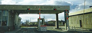
Alcan Border, also known as Port Alcan, is a census-designated place in the Southeast Fairbanks Census Area in the U.S. state of Alaska. Part of the Unorganized Borough, Alcan Border is the site of the Alcan - Beaver Creek Border Crossing, the main U.S. port of entry for persons arriving in Alaska by road. The population was 33 at the 2010 census, up from 21 in 2000.

Deltana is a census-designated place (CDP) in the Southeast Fairbanks Census Area, Alaska, United States. At the 2020 census, the population was 2,359, up from 2,251 in 2010. Native inhabitants are Tanana Athabaskans.

<span class="mw-page-title-main">Tetlin, Alaska</span> CDP in Alaska, United States

Tetlin is a census-designated place (CDP) in Southeast Fairbanks Census Area, Alaska, United States. At the 2010 census the population was 127, up from 117 in 2000.

<span class="mw-page-title-main">Chisana, Alaska</span> CDP in Alaska, United States

Chisana is a census-designated place (CDP) in the Copper River Census Area in the U.S. state of Alaska. As of the 2010 Census, the population of the CDP was 0. The English name Chisana derives from the Ahtna Athabascan name Tsetsaan' Na, meaning literally 'copper river'. The Chisana River joins the Nabesna River just north of Northway Junction, Alaska, to form the Tanana River, a major tributary of the Yukon River. The Chisana Airport consists of a turf and gravel runway which is largely serviced by flights from Tok, Alaska.

References

  1. In 1980, the United States Census Bureau divided the Unorganized Borough into 12 census areas.
  2. 1 2 "2020 Census Data - Cities and Census Designated Places" (Web). State of Alaska, Department of Labor and Workforce Development. Retrieved October 31, 2021.
  3. 1 2 "State & County QuickFacts". United States Census Bureau. Archived from the original on May 19, 2014. Retrieved May 18, 2014.
  4. "US Gazetteer files: 2010, 2000, and 1990". United States Census Bureau. February 12, 2011. Retrieved April 23, 2011.
  5. Elections, RRH (February 2, 2018). "RRH Elections". rrhelections.com. Retrieved January 12, 2020.
  6. "Annual Estimates of the Resident Population for Counties: April 1, 2020 to July 1, 2023". United States Census Bureau. Retrieved March 28, 2024.
  7. "U.S. Decennial Census". United States Census Bureau. Retrieved May 18, 2014.
  8. "Population of Counties by Decennial Census: 1900 to 1990". United States Census Bureau. Retrieved May 18, 2014.
  9. "Census 2000 PHC-T-4. Ranking Tables for Counties: 1990 and 2000" (PDF). United States Census Bureau. Archived (PDF) from the original on October 9, 2022. Retrieved May 18, 2014.
  10. "U.S. Census website". United States Census Bureau . Retrieved May 14, 2011.
  11. Language Map Data Center. Mla.org (April 3, 2013). Retrieved on August 2, 2013.
  12. "2020 Census Demographic Data Map Viewer".

Commons-logo.svg Media related to Southeast Fairbanks Census Area, Alaska at Wikimedia Commons

63°46′N143°36′W / 63.77°N 143.60°W / 63.77; -143.60