Related Research Articles

Alaska is a non-contiguous U.S. state on the northwest extremity of North America. It borders the Canadian province of British Columbia and the Yukon territory to the east; it shares a western maritime border in the Bering Strait with Russia's Chukotka Autonomous Okrug. The Chukchi and Beaufort Seas of the Arctic Ocean lie to the north and the Pacific Ocean lies to the south. Technically a semi-exclave of the U.S., it is the largest exclave in the world.
A ferry is a watercraft that carries passengers, and sometimes vehicles and cargo, across a body of water. A small passenger ferry with many stops, such as in Venice, Italy, is sometimes called a water taxi or water bus.

Hoonah is a largely Tlingit community on Chichagof Island, located in Alaska's panhandle in the southeast region of the state. It is 30 miles (48 km) west of Juneau, across the Alaskan Inside Passage. Hoonah is the only first-class city on Chichagof Island, the 109th-largest island in the world and the 5th-largest island in the U.S. At the 2020 census the population was 931, up from 760 in 2010. In the summer the population can swell to over 1,300 depending on fishing, boating, hiking and hunting conditions.

The Kenai Peninsula is a large peninsula jutting from the coast of Southcentral Alaska. The name Kenai is derived from the word "Kenaitze" or "Kenaitze Indian Tribe", the name of the Native Athabascan Alaskan tribe, the Kahtnuht’ana Dena’ina, who historically inhabited the area. They called the Kenai Peninsula Yaghanen.
A riverboat is a watercraft designed for inland navigation on lakes, rivers, and artificial waterways. They are generally equipped and outfitted as work boats in one of the carrying trades, for freight or people transport, including luxury units constructed for entertainment enterprises, such as lake or harbour tour boats. As larger water craft, virtually all riverboats are especially designed and constructed, or alternatively, constructed with special-purpose features that optimize them as riverine or lake service craft, for instance, dredgers, survey boats, fisheries management craft, fireboats and law enforcement patrol craft.

Prince of Wales Island is one of the islands of the Alexander Archipelago in the Alaska Panhandle. It is the fourth-largest island in the United States and the 97th-largest island in the world.
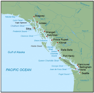
The Inside Passage is a coastal route for ships and boats along a network of passages which weave through the islands on the Pacific Northwest coast of the North American Fjordland. The route extends from southeastern Alaska in the United States, through western British Columbia in Canada, to northwestern Washington state in the United States. Ships using the route can avoid some of the bad weather in the open ocean and may visit some of the many isolated communities along the route. The Inside Passage is heavily travelled by cruise ships, freighters, tugs with tows, fishing craft, pleasure craft, and ships of the Alaska Marine Highway, BC Ferries, and Washington State Ferries systems. Coast Guard vessels of both Canada and the United States patrol and transit in the Passage.
The Alaska Marine Highway (AMH) or the Alaska Marine Highway System (AMHS) is a ferry service operated by the U.S. state of Alaska. It has its headquarters in Ketchikan, Alaska.
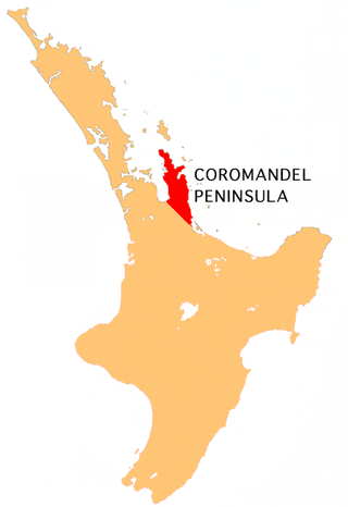
The Coromandel Peninsula on the North Island of New Zealand extends 85 kilometres (53 mi) north from the western end of the Bay of Plenty, forming a natural barrier protecting the Hauraki Gulf and the Firth of Thames in the west from the Pacific Ocean to the east. It is 40 kilometres (25 mi) wide at its broadest point. Almost its entire population lives on the narrow coastal strips fronting the Hauraki Gulf and the Bay of Plenty. In clear weather the peninsula is clearly visible from Auckland, the country's biggest city, which lies on the far shore of the Hauraki Gulf, 55 kilometres (34 mi) to the west. The peninsula is part of the Thames-Coromandel District and the Waikato Region.

The Aniakchak River is a stream, 27 miles (43 km) long, in Lake and Peninsula Borough on the Alaska Peninsula in the United States. It arises in Surprise Lake in the crater of Mount Aniakchak, a volcano in the Aleutian Range. It flows eastward from Aniakchak National Monument and Preserve into Aniakchak Bay and the Pacific Ocean.

The six main types of motorcycles are generally recognized as standard, cruiser, touring, sports, off-road, and dual-purpose. Sport touring is sometimes recognized as a seventh category or integrated with the touring category.

An aircraft stabilizer is an aerodynamic surface, typically including one or more movable control surfaces, that provides longitudinal (pitch) and/or directional (yaw) stability and control. A stabilizer can feature a fixed or adjustable structure on which any movable control surfaces are hinged, or it can itself be a fully movable surface such as a stabilator. Depending on the context, "stabilizer" may sometimes describe only the front part of the overall surface.
This article discusses transportation in the U.S. state of Alaska.

Southwest Alaska is a region of the U.S. state of Alaska. The area is not exactly defined by any governmental administrative region(s); nor does it always have a clear geographic boundary.

Bunny boots or Mickey Mouse boots are the most common nicknames for the Extreme Cold Vapor Barrier Boots used by the United States Armed Forces. These large, bulbous, waterproof rubber boots can be worn in extremely cold weather, −20 to −60 °F, with the liner-free interior retaining warmth by sandwiching up to one inch of wool and felt insulation between two vacuum-tight layers of rubber; this vacuum layer insulates the wearer's feet similar to a vacuum flask. These boots were originally developed at the Navy Clothing and Textile Research Center in Natick, Massachusetts, for use during the Korean War.
The Alaska Department of Transportation & Public Facilities (DOT&PF) is a department within the government of Alaska. Its headquarters are in Alaska's capital city, Juneau. The mission of Alaska DOT&PF is to "Keep Alaska Moving through service and infrastructure."The Alaska Department of Transportation was established on July 1, 1977, by Alaska Highway Commissioner Walter Parker during the administration of Governor Jay Hammond. The Alaska Department of Transportation and Public Facilities merged the former departments of Highways and Public Works.
Charles P. Wohlforth is an author and journalist, former public official, and consultant. He has written extensively about Alaska and has collaborated with other authors on a variety of topics.
Taquan Air is the operating name for Venture Travel, LLC, an American regional airline headquartered in Ketchikan, a city in the southeastern portion of the U.S. state of Alaska. It operates domestic scheduled passenger and charter services. Its base is Ketchikan Harbor Seaplane Base, which shares the same harbor and airspace as Ketchikan International Airport. As per the United States Department of Transportation in a report dated August 2, 2010, Taquan Air is a "U.S. Certificated Air Carrier", and is 1 of 125 such carriers in the US.
The Nome–Council Highway is a highway that runs for 71.970 miles (115.824 km) between the communities of Council and Nome in the Nome Census Area of the Unorganized Borough in the U.S. state of Alaska. The road travels east from Nome, following the shore of the Bering Sea until it reaches the ghost town of Solomon. From there, the route travels northeast through the interior of the Seward Peninsula before it terminates on the south bank of the Niukluk River, south of Council. One of three highways traveling from Nome to surrounding communities, the highway is disconnected from the rest of the Alaska Highway System. The route is unpaved for its entire length and becomes impassable for automobiles in the winter outside of a short portion immediately outside of Nome. The portion of the road between Nome and Solomon is part of the Iditarod Trail and the highway passes several historic sites associated with the trail and the area's gold mining history.
References
- 1 2 3 4 5 Wohlforth, Charles P. (2007). Alaska for Dummies (3rd ed.). For Dummies. p. 364. ISBN 978-0-471-94555-0.
- 1 2 3 4 5 6 7 8 9 DeVaughn, Melissa (2008). The Unofficial Guide to Adventure Travel in Alaska (2nd ed.). John Wiley and Sons. p. 457. ISBN 978-0-470-22899-9.
- ↑ Wohlforth, Charles P. (2007). Frommer's Alaska 2008. Frommer's. p. 434. ISBN 978-0-470-15288-1.
