Nome Census Area, Alaska

Last updated

Nome Census Area
SIDE AND FRONT - Iditarod Trail Shelter Cabins, Cape Nome Roadhouse, Cape Nome, Nome Census Area, AK HABS AK,9-SEW,2-M-5 (CT).tif
Map of Alaska highlighting Nome Census Area.svg
Location within the U.S. state of Alaska
Alaska in United States (US50).svg
Alaska's location within the U.S.
Coordinates: 64°44′N164°11′W / 64.74°N 164.19°W / 64.74; -164.19
CountryFlag of the United States.svg United States
StateFlag of Alaska.svg  Alaska
Established1980 [1]
Named for Nome
Largest city Nome
Area
  Total28,278 sq mi (73,240 km2)
  Land22,962 sq mi (59,470 km2)
  Water5,316 sq mi (13,770 km2)  18.8%
Population
 (2020)
  Total10,046
  Estimate 
(2022)
9,835 Decrease2.svg
  Density0.36/sq mi (0.14/km2)
Time zone UTC−9 (Alaska)
  Summer (DST) UTC−8 (ADT)
Congressional district At-large

Nome Census Area is a census area located in the U.S. state of Alaska, mostly overlapping with the Seward Peninsula. As of the 2020 census, the population was 10,046, up from 9,492 in 2010. [2] It is part of the unorganized borough and therefore has no borough seat. Its largest community by far is the city of Nome.

Contents

Geography

According to the United States Census Bureau, the census area has a total area of 28,278 square miles (73,240 km2), of which 22,962 square miles (59,470 km2) is land and 5,316 square miles (13,770 km2) (18.8%) is water. [3] It also includes the large offshore St. Lawrence Island, which has about 14 percent of the census area's population and two of its larger cities in Gambell and Savoonga. Nome Census Area is the 7th largest county-equivalent in the state of Alaska.

Adjacent boroughs and census areas

National protected areas

Politics

United States presidential election results for Nome Census Area, Alaska [4]
Year Republican Democratic Third party
No.%No.%No.%
2020 1,28735.09%2,13158.10%2506.82%
2016 93528.40%1,68951.31%66820.29%
2012 1,09630.80%2,26463.61%1995.59%
2008 1,61848.31%1,72851.60%30.09%
2004 1,48952.91%1,17141.61%1545.47%
2000 1,63751.51%1,21738.29%32410.20%
1996 1,20640.42%1,44448.39%33411.19%
1992 1,14738.01%1,22240.49%64921.50%
1988 1,45257.17%99339.09%953.74%
1984 1,65759.60%1,05938.09%642.30%
1980 93843.41%95344.10%27012.49%
1976 98951.16%88745.89%572.95%
1972 91149.48%81244.11%1186.41%
1968 81744.21%92950.27%1025.52%
1964 41023.60%1,32776.40%00.00%
1960 1,00755.98%79244.02%00.00%

Demographics

Historical population
CensusPop.Note
1960 6,091
1970 5,749−5.6%
1980 6,53713.7%
1990 8,28826.8%
2000 9,19611.0%
2010 9,4923.2%
2020 10,0465.8%
2023 (est.)9,763 [5] −2.8%
U.S. Decennial Census [6]
1790-1960 [7] 1900-1990 [8]
1990-2000 [9] 2010-2020 [2]

2020 Census

Races (alone or in combination with other) in Nome Census Area (2020 United States Census) [10]
RacePercentage of Population
White 21.83%
Black or African American 1.16%
American Indian or Alaska Native 82.57%
Asian 2.19%
Native Hawaiian and Other Pacific Islander 0.37%
Some other race1.26%

2000 census

As of the census of 2000, there were 9,196 people, 2,693 households, and 1,898 families living in the census area. The population density was 0.3 people per square mile (0.12 people/km2). There were 3,649 housing units at an average density of 0 per square mile (0/km2). The racial makeup of the census area was 19.32% White, 0.38% Black or African American, 75.20% Native American, 0.67% Asian, 0.02% Pacific Islander, 0.20% from other races, and 4.21% from two or more races. 1.00% of the population were Hispanic or Latino of any race. 16.32% reported speaking a Yupik language at home, while 8.75% speak Inupiaq; a further 2.02% reported speaking "Eskimo", a term that covers both Yupik and Inupiaq. [11]

Of the 2,693 households, 45.80% had children under the age of 18 living with them, 42.40% were married couples living together, 15.30% had a female householder with no husband present, and 29.50% were non-families. 23.20% of households were one person, and 3.30% were one person aged 65 or older. The average household size was 3.33 and the average family size was 4.01.

In the census area the population was spread out, with 37.10% under the age of 18, 9.30% from 18 to 24, 29.00% from 25 to 44, 18.60% from 45 to 64, and 5.90% 65 or older. The median age was 28 years. For every 100 females, there were 117.60 males. For every 100 females age 18 and over, there were 122.70 males.

Communities

Cities

Census-designated place

Unincorporated communities

See also

Related Research Articles

<span class="mw-page-title-main">Aleutians West Census Area, Alaska</span> Census area in Alaska, United States

Aleutians West Census Area is a census area located in the U.S. state of Alaska. As of the 2020 census, the population was 5,232, down from 5,561 in 2010.

<span class="mw-page-title-main">Bethel Census Area, Alaska</span> Census area in Alaska, United States

Bethel Census Area is a census area in the U.S. state of Alaska. As of the 2020 census, the population is 18,666, up from 17,013 in 2010. It is part of the unorganized borough and therefore has no borough seat. Its largest community is the city of Bethel, which is also the largest city in the unorganized borough.

<span class="mw-page-title-main">Dillingham Census Area, Alaska</span> Census area in Alaska, United States

Dillingham Census Area is a census area located in the state of Alaska, United States. At the 2020 census, the population was 4,857, slightly up from 4,847 in 2010. It is part of the unorganized borough and therefore has no borough seat. Its largest community by far is the city of Dillingham, on a small arm of Bristol Bay on the Bering Sea.

<span class="mw-page-title-main">Haines Borough, Alaska</span> Borough in Alaska, United States

Haines Borough is a home-rule borough located in the state of Alaska. As of the 2020 census, the population was 2,080, down from 2,508 in 2010.

<span class="mw-page-title-main">Lake and Peninsula Borough, Alaska</span> Borough in Alaska, United States

Lake and Peninsula Borough is a borough in the state of Alaska. As of the 2020 census, the population was 1,476, down from 1,631 in 2010. The borough seat of King Salmon is located in neighboring Bristol Bay Borough, although is not the seat of that borough. The most populous community in the borough is the census-designated place of Port Alsworth. With an average of 0.017 inhabitants per square kilometre, the Lake and Peninsula Borough is the second least densely populated organized county-equivalent in the United States; only the unorganized Yukon-Koyukuk Census Area has a lower density.

<span class="mw-page-title-main">Northwest Arctic Borough, Alaska</span> Borough in Alaska, United States

Northwest Arctic Borough is a borough located in the U.S. state of Alaska. As of the 2020 census, the population was 7,793, up from 7,523 in 2010. The borough seat is Kotzebue. The borough was formed on June 2, 1986.

<span class="mw-page-title-main">Prince of Wales–Hyder Census Area, Alaska</span> Census area in Alaska, United States

Prince of Wales–Hyder Census Area is a census area located in the U.S. state of Alaska. As of the 2020 census, the population was 5,753, up from 5,559 in 2010. It is part of the unorganized borough and therefore has no borough seat. Its largest communities are Metlakatla and Craig. It was formerly part of the Census Bureau's Prince of Wales–Outer Ketchikan Census Area, but the name was changed in 2008 after most of the Outer Ketchikan was lost to annexation by the Ketchikan Gateway Borough.

<span class="mw-page-title-main">Hoonah–Angoon Census Area, Alaska</span> Census area in Alaska, United States

Hoonah–Angoon Census Area is a census area located in the U.S. state of Alaska. As of the 2020 census, the population was 2,365, up from 2,150 in 2010. It is part of the unorganized borough and therefore has no borough seat. Its largest community is the city of Hoonah.

<span class="mw-page-title-main">Southeast Fairbanks Census Area, Alaska</span> Census area in Alaska, United States

Southeast Fairbanks Census Area is a census area located in the U.S. state of Alaska. As of the 2020 census, the population was 6,808, down from 7,029 in 2010. It is part of the unorganized borough and therefore has no borough seat. Its largest communities are Deltana and Tok, both unincorporated CDPs.

<span class="mw-page-title-main">Kusilvak Census Area, Alaska</span> Census area in Alaska, United States

Kusilvak Census Area, formerly known as Wade Hampton Census Area, is a census area located in the U.S. state of Alaska. As of the 2020 census, the population was 8,368, up from 7,459 in 2010. It is part of the Unorganized Borough and therefore has no borough seat. Its largest community is the city of Hooper Bay, on the Bering Sea coast.

<span class="mw-page-title-main">Yukon–Koyukuk Census Area, Alaska</span> Census area in Alaska, United States

Yukon–Koyukuk Census Area is a census area in the U.S. state of Alaska. As of the 2020 census, the population was 5,343, down from 5,588 in 2010. With an area of 147,842.51 sq mi (382,910.3 km2), it is the largest of any county or county-equivalent in the United States, or about the same size as the entire state of Montana. It is part of the unorganized borough of Alaska and therefore has no borough seat. Its largest communities are the cities of Galena, in the west, and Fort Yukon, in the northeast.

<span class="mw-page-title-main">Gambell, Alaska</span> City in Alaska, United States

Gambell(GAM-bull) is a city in the Nome Census Area of the U.S. state of Alaska. Located on St. Lawrence Island, it had a population of 681 at the 2010 census, up from 649 in 2000.

<span class="mw-page-title-main">Golovin, Alaska</span> City in Alaska, United States

Golovin is a city in Nome Census Area, Alaska, United States. At the 2010 census the population was 156, up from 144 in 2000.

<span class="mw-page-title-main">Savoonga, Alaska</span> City in Alaska, United States

Savoonga is a city in Nome Census Area, Alaska. It is located on St. Lawrence Island in the Bering Sea. As of the 2020 census, Savoonga's population was 835, up from 671 in 2010.

<span class="mw-page-title-main">Shaktoolik, Alaska</span> City in Alaska, United States

Shaktoolik is a city in Nome Census Area, Alaska, United States. At the 2010 census the population was 251, up from 230 in 2000. Shaktoolik is one of a number of Alaskan communities threatened by erosion and related global warming effects. The community has been relocated twice.

St. Michael, historically referred to as Saint Michael, is a city in Nome Census Area, Alaska. The population was 401 at the 2010 census, up from 368 in 2000.

Stebbins is a city in Nome Census Area, Alaska, United States. At the 2010 census the population was 556, up from 547 in 2000.

Marshall is a city in Kusilvak Census Area, Alaska, United States. At the 2010 census the population was 414, up from 349 in 2000.

<span class="mw-page-title-main">St. Lawrence Island</span> Island in the Bering Sea, part of Alaska, United States

St. Lawrence Island is located west of mainland Alaska in the Bering Sea, just south of the Bering Strait. The village of Gambell, located on the northwest cape of the island, is 50 nautical miles from the Chukchi Peninsula in the Russian Far East. The island is part of Alaska, but closer to Russia and Asia than to the Alaskan and North American mainland. St. Lawrence Island is thought to be one of the last exposed portions of the land bridge that once joined Asia with North America during the Pleistocene period. It is the sixth largest island in the United States and the 113th largest island in the world. It is considered part of the Bering Sea Volcanic Province. The Saint Lawrence Island shrew is a species of shrew endemic to St. Lawrence Island. The island is jointly owned by the predominantly Siberian Yupik villages of Gambell and Savoonga, the two main settlements on the island.

<span class="mw-page-title-main">Solomon, Alaska</span> Unincorporated community in the state of Alaska, United States

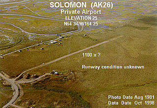
Solomon is an unincorporated community in the Nome Census Area of the Unorganized Borough of Alaska. As of the 2010 census, the population was zero (uninhabited), down from four in 2000.

References

  1. In 1980, the United States Census Bureau divided the Unorganized Borough into 12 census areas.
  2. 1 2 "State & County QuickFacts". United States Census Bureau. Retrieved April 20, 2023.
  3. "US Gazetteer files: 2010, 2000, and 1990". United States Census Bureau. February 12, 2011. Retrieved April 23, 2011.
  4. Elections, RRH (February 2, 2018). "RRH Elections". rrhelections.com. Retrieved January 12, 2020.
  5. "Annual Estimates of the Resident Population for Counties: April 1, 2020 to July 1, 2023". United States Census Bureau. Retrieved March 28, 2024.
  6. "U.S. Decennial Census". United States Census Bureau. Retrieved May 18, 2014.
  7. "Historical Census Browser". University of Virginia Library. Retrieved May 18, 2014.
  8. "Population of Counties by Decennial Census: 1900 to 1990". United States Census Bureau. Retrieved May 18, 2014.
  9. "Census 2000 PHC-T-4. Ranking Tables for Counties: 1990 and 2000" (PDF). United States Census Bureau. Archived (PDF) from the original on October 9, 2022. Retrieved May 18, 2014.
  10. "2020 Census Demographic Data Map Viewer".
  11. MLA Language Map Data Center

64°44′N164°11′W / 64.74°N 164.19°W / 64.74; -164.19