Brevig Mission, Alaska

Last updated

Brevig Mission
Sitaisaq (Inupiaq)
Brevig Mission Alaska - Drone 2018.jpg
Brevig Mission in 2017
USA Alaska location map.svg
Red pog.svg
Brevig Mission
Location in Alaska
Coordinates: 65°20′3″N166°29′35″W / 65.33417°N 166.49306°W / 65.33417; -166.49306
CountryUnited States
State Alaska
Census Area Nome
Incorporated October 6, 1969 [1]
Government
   Mayor Adrien Barr [2]
   State senator Donny Olson (D)
   State rep. Neal Foster (D)
Area
[3]
  Total2.51 sq mi (6.51 km2)
  Land2.43 sq mi (6.30 km2)
  Water0.08 sq mi (0.21 km2)
Elevation
16 ft (5 m)
Time zone UTC-9 (Alaska (AKST))
  Summer (DST) UTC-8 (AKDT)
ZIP code
99785
Area code 907
FIPS code 02-08740
GNIS feature ID 1420670

Brevig Mission (Inupiaq: Sitaisaq, Sitaisat, or Sinauraq) is a city in Nome Census Area, Alaska. The population was 388 at the 2010 census, up from 276 in 2000. It is named for the Norwegian Lutheran pastor Tollef L. Brevig, who served at the mission that would later bear his name. [4] First settled in 1900, the mission became known as Teller Mission before receiving its current name. The mostly Inupiat Eskimo population continues to practice subsistence. Brevig Mission is a dry village, which means the sale or possession of alcohol is illegal. [5]

Contents

Geography

Brevig Mission is located at 65°20′3″N166°29′35″W / 65.33417°N 166.49306°W / 65.33417; -166.49306 (65.334235, -166.492952). [6]

According to the United States Census Bureau, the city has a total area of 2.6 square miles (6.7 km2), of which, 2.6 square miles (6.7 km2) of it is land and 0.1 square miles (0.26 km2) of it (1.89%) is water.

Demographics

Historical population
CensusPop.Note
1950 109
1960 77−29.4%
1970 12359.7%
1980 13812.2%
1990 19843.5%
2000 27639.4%
2010 38840.6%
U.S. Decennial Census [7] [ failed verification ]
Native huts and storage platforms, with platform graves in the distance, Teller reindeer station (1894) Annual report on introduction of domesticated reindeer into Alaska (1894) (19180127278).jpg
Native huts and storage platforms, with platform graves in the distance, Teller reindeer station (1894)

Brevig Mission first appeared on the 1950 [8] U.S. Census and in 1960 [9] as the unincorporated village of "Teller Mission." [10] In 1969, it was formally incorporated under its present name of Brevig Mission.

As of the census of 2000, [11] there were 276 people, 68 households, and 53 families residing in the city. The population density was 106.3 inhabitants per square mile (41.0/km2). There were 76 housing units at an average density of 29.3 per square mile (11.3/km2). The racial makeup of the city was 8.0% White, 90.6% Native American, and 1.5% from two or more races. Hispanic or Latino of any race were 0.7% of the population.

Of the 68 households, 52.9% had children under the age of 18 living with them, 30.9% were married couples living together, 25.0% had a female householder with no husband present, and 20.6% were non-families. 14.7% of all households were made up of individuals, and none had someone living alone who was 65 years of age or older. The average household size was 4.06 and the average family size was 4.35.

In the city, the age distribution of the population shows 45.3% under the age of 18, 12.3% from 18 to 24, 28.6% from 25 to 44, 10.1% from 45 to 64, and 3.6% who were 65 years of age or older. The median age was 20 years. For every 100 females, there were 101.5 males. For every 100 females age 18 and over, there were 118.8 males.

The median income for a household in the city was $21,875, and the median income for a family was $16,786. Males had a median income of $11,250 versus $25,000 for females. The per capita income for the city was $7,278. About 43.3% of families and 48.4% of the population were below the poverty line, including 50.8% of those under age 18 and none of those age 65 or over.

Education

Brevig Mission is served by the Bering Strait School District. Brevig Mission School serves grades Pre-K through 12.

1918 Spanish Flu

The pandemic caused by the 1918 influenza outbreak was by far the most devastating single disease outbreak in modern history, killing at least 50 million people during an 18-month period. In Brevig Mission alone, it killed 72 out of 80 residents in a 5-day period. [12] The 72 victims were buried in the frozen ground in a mass grave dug for them by gold miners and marked by white crosses. [13] As happened elsewhere in the Americas after the arrival of Columbus, Indigenous Alaska Natives had no genetic resistance to any flu, so it decimated many villages. [12]

In 1997, a team of scientists led by Johan Hultin exhumed the frozen remains of an Iñupiat woman who had been buried in the permafrost in a gravesite near Brevig Mission in a successful attempt to recover RNA from her lung tissue. [14] It enabled them to analyze the structure of the 1918 influenza virus (Spanish flu), which may have originated in Fort Riley, Kansas, that killed her.

Health

Sale, importation and possession of alcohol are banned in the village. [15]

Related Research Articles

<span class="mw-page-title-main">Nome Census Area, Alaska</span> Census area in Alaska, United States

Nome Census Area is a census area located in the U.S. state of Alaska, mostly overlapping with the Seward Peninsula. As of the 2020 census, the population was 10,046, up from 9,492 in 2010. It is part of the unorganized borough and therefore has no borough seat. Its largest community by far is the city of Nome.

<span class="mw-page-title-main">North Slope Borough, Alaska</span> Borough in Alaska, United States

The North Slope Borough is the northernmost borough in the US state of Alaska and thus, the northernmost county or equivalent of the United States as a whole. As of the 2020 census, the population was 11,031. The borough seat and largest city, comprising nearly 1/2 of the borough’s population, is Utqiaġvik, the northernmost settlement in the United States.

<span class="mw-page-title-main">Northwest Arctic Borough, Alaska</span> Borough in Alaska, United States

Northwest Arctic Borough is a borough located in the U.S. state of Alaska. As of the 2020 census, the population was 7,793, up from 7,523 in 2010. The borough seat is Kotzebue. The borough was formed on June 2, 1986.

<span class="mw-page-title-main">Chuathbaluk, Alaska</span> City in Alaska, United States

Chuathbaluk is a city in Bethel Census Area, Alaska, United States.

Upper Kalskag is a city in Bethel Census Area, Alaska, United States. It is thirty miles west of Aniak. At the 2010 census the population was 210, down from 230 in 2000.

<span class="mw-page-title-main">Golovin, Alaska</span> City in Alaska, United States

Golovin is a city in Nome Census Area, Alaska, United States. At the 2010 census the population was 156, up from 144 in 2000.

<span class="mw-page-title-main">Teller, Alaska</span> City in Alaska, United States

Teller is a city in the Nome Census Area, Alaska, United States. At the 2010 census the population was 229, a decrease from 268 in 2000.

<span class="mw-page-title-main">Unalakleet, Alaska</span> City in Alaska, United States

Unalakleet is a city in Nome Census Area, Alaska, United States, in the western part of the state. At the 2010 census the population was 688, down from 747 in 2000. Unalakleet is known in the region and around Alaska for its salmon and king crab harvests; the residents rely for much of their diet on caribou, ptarmigan, oogruk, and various salmon species.

<span class="mw-page-title-main">Wales, Alaska</span> City in Alaska, United States

Wales is a city in the Nome Census Area, Alaska, United States. At the 2010 census the population was 145, down from 152 in 2000. It is the westernmost city on the North American mainland, although Adak, located on Adak Island, is the westernmost city in Alaska. Wales Airport serves Wales with flights on Bering Air and Ravn Alaska to Nome.

<span class="mw-page-title-main">White Mountain, Alaska</span> City in Alaska, United States

White Mountain is a city in Nome Census Area, Alaska, United States. The population was 190 at the 2010 census, down from 203 in 2000. The city is an Iġaluŋmiut Inupiat village, with historical influences from and relationships with Qawiaraq Inupiat and Golovin and Elim Yup’iks. 86.2% of the population is Alaska Native or part Native. Subsistence activities are prevalent. White Mountain is the only village on the Seward Peninsula located inland, not on the ocean.

<span class="mw-page-title-main">Kaktovik, Alaska</span> City in Alaska, United States

Kaktovik is a city in North Slope Borough, Alaska, United States. The population was 283 at the 2020 census.

Point Hope is a city in North Slope Borough, Alaska, United States. At the 2010 census the population was 674, down from 757 in 2000. In the 2020 Census, the population rose to 830.

<span class="mw-page-title-main">Deering, Alaska</span> City in Alaska, United States

Deering is a city in the Northwest Arctic Borough in the U.S. state of Alaska. It is located on a sandy spit on the Seward Peninsula where the Inmachuk River flows into Kotzebue Sound, 92 km (57 mi) southwest of Kotzebue.

<span class="mw-page-title-main">Noatak, Alaska</span> Place in Alaska, United States

Noatak is a census-designated place (CDP) in the Northwest Arctic Borough in the U.S. state of Alaska. The population was 570 at the 2020 census, up from 514 in 2010. It is served by Noatak Airport.

<span class="mw-page-title-main">Noorvik, Alaska</span> City in Alaska, United States

Noorvik is an Iñupiat city in the Northwest Arctic Borough in the U.S. state of Alaska. As of the 2020 census, the population of the city was 694, up from 668 in 2010. Located in the NANA Region Corp, Noorvik has close ties with the largest city in the region, Kotzebue. Residents speak a dialect of Iñupiaq known as Noorvik Inupiaq. Noorvik was the first town to be counted in the 2010 census.

<span class="mw-page-title-main">Hooper Bay, Alaska</span> Town in Alaska

Hooper Bay is a city in Kusilvak Census Area, Alaska, United States. At the 2020 census the population was 1,375, up from 1,093 in 2010.

<span class="mw-page-title-main">Russian Mission, Alaska</span> City in Alaska, United States

Russian Mission is a city in Kusilvak Census Area, Alaska. It was the location of a fur trading post of the Russian-American Company in 1842. After the sale of Russian-American possessions to the United States in 1867, it was officially named Russian Mission in the early 1900s. The sale of alcohol is prohibited. At the 2020 census the population was 421, up from 312 in 2010.

<span class="mw-page-title-main">Koyukuk, Alaska</span> City in Alaska, United States

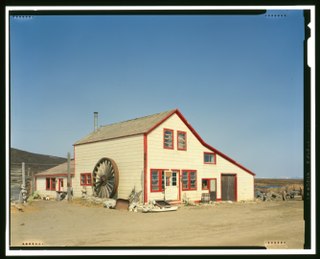
Koyukuk is a city in Yukon-Koyukuk Census Area, Alaska, United States. At the 2010 census the population was 96, down from 101 in 2000.

<span class="mw-page-title-main">Nulato, Alaska</span> City in Alaska, United States

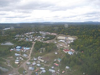
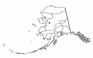
Nulato is a city in Yukon-Koyukuk Census Area, Alaska, United States. At the 2020 census, the population was 239.

<span class="mw-page-title-main">Tanana, Alaska</span> City in the Yukon-Koyukuk Census Area in Alaska, United States

Tanana is a city in the Yukon-Koyukuk Census Area in the U.S. state of Alaska. At the 2010 census the population was 246, down from 308 in 2000. It was formerly known as Clachotin, adopted by Canadian French.

References

  1. 1996 Alaska Municipal Officials Directory. Juneau: Alaska Municipal League/Alaska Department of Community and Regional Affairs. January 1996. p. 34.
  2. 2023 Alaska Municipal Officials Directory (PDF). Juneau: Alaska Municipal League. January 2023. p. 51. Retrieved November 12, 2023.
  3. "2020 U.S. Gazetteer Files". United States Census Bureau. Retrieved October 29, 2021.
  4. "Brevig Mission – Kawerak". kawerak.org. Retrieved July 28, 2019.
  5. "Brevig Mission and Teller, Alaska | Maruskiya's of Nome Alaska Native Art". www.maruskiyas.com. Retrieved July 28, 2019.
  6. "US Gazetteer files: 2010, 2000, and 1990". United States Census Bureau. February 12, 2011. Retrieved April 23, 2011.
  7. "Census of Population and Housing". Census.gov. Retrieved June 4, 2015.
  8. "Number of Inhabitants - Alaska" (PDF). United States Census Bureau. 1950.
  9. "Number of Inhabitants - Alaska" (PDF). United States Census Bureau. 1960.
  10. "Geological Survey Professional Paper". 1949.
  11. "U.S. Census website". United States Census Bureau . Retrieved January 31, 2008.
  12. 1 2 "Permafrost Preserves Clues to Deadly 1918 Flu, Alaska Science Forum". gi.alaska.edu. Archived from the original on April 19, 2012. Retrieved July 3, 2007.
  13. McKnight, Michael (May 27, 2020). "Into the Wild. Twice. For Mankind". si.com. Retrieved August 21, 2020.
  14. Kolata, Gina (January 27, 2022). "Johan Hultin, Who Found Frozen Clues to 1918 Virus, Dies at 97". New York Times. Retrieved January 30, 2022.
  15. "Schedule of Local Option Communities" (PDF). Alcoholic Beverage Control Board. Retrieved May 3, 2023.

Commons-logo.svg Media related to Brevig Mission, Alaska at Wikimedia Commons