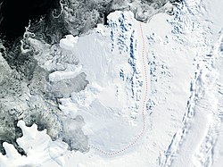
Alexander Island, also known as Alexander I Island, Alexander I Land, Alexander Land, Alexander I Archipelago, and Zemlja Alexandra I, is the largest island of Antarctica. It lies in the Bellingshausen Sea west of Palmer Land, Antarctic Peninsula from which it is separated by Marguerite Bay and George VI Sound. The George VI Ice Shelf entirely fills George VI Sound and connects Alexander Island to Palmer Land. The island partly surrounds Wilkins Sound, which lies to its west.[1] Alexander Island is about 390 kilometres (240mi) long in a north–south direction, 80 kilometres (50mi) wide in the north, and 240 kilometres (150mi) wide in the south.[2] Alexander Island is the second-largest uninhabited island in the world, after Devon Island.
Satellite photo of Alexander Island (NASA imagery)Alexander Island Mountain Ranges
The surface of Alexander Island is predominantly ice-covered. There exist some exposed nunataks and a few ice-free areas of significant size, including Ablation Point Massif. The nunataks are the peaks of north–south trending mountain ranges and hills. They include the Colbert, Havre, Lassus, Rouen, Sofia University, and Walton Mountains, the Staccato Peaks, the Lully Foothills, the Finlandia Foothills, the Elgar Uplands, and the Douglas Range. These mountains, peaks, hills, and uplands are surrounded by a permanent ice sheet, which consists of glaciers that flow off of Alexander Island. These glaciers flow west into the Bach and Wilkins Ice Shelves and Bellingshausen Sea, and east into the George VI Ice Shelf. The George VI Ice Shelf is fed by both by outlet glaciers from the ice cap on Palmer Land and Alexander Island.[1][2][7]
Another notable feature of Alexander Island is Hodgson Lake, a former subglacial lake that has emerged from under an ice sheet that had covered it. Hodgson Lake is 2km (1.2mi) long by 1.5km (0.93mi), and has a 93.4m (306ft) deep water column that lies sealed beneath a 3.6 to 4.0m (11.8 to 13.1ft) thick perennial lake ice.
The northern side of Hodgson Lake is bounded by the Saturn Glacier, which flows east into George VI Sound, while the southern side of Hodgson Lake is bounded by the northern face of Citadel Bastion. During the Last Glacial Maximum, Hodgson Lake was covered by the ice sheet at least 470m (1,540ft) thick.
This ice sheet started thinning about 13,500 years ago. It retreated and left Hodgson Lake covered by perennial ice sometime before 11,000 years ago. This lake has been covered by perennial ice since that time.[8][9]
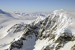
Antarctic Peninsula's tectonic movementFossil Bluff base on Alexander Island
According to Hole, "The geology of Alexander Island can be attributed mainly to processes associated with the subduction of proto-Pacific oceanic crust along the western margin of the Antarctic Peninsula, from latest Triassic to Late Tertiary times." The LeMay Group accretionary prism complex, along with plutonic and volcanic rocks, are prevalent along the western portion of the island. The LeMay Group consists of variably-deformed and metamorphosed sedimentary and igneous rocks. Although it is dominated by deformed arkosic sedimentary rocks, it includes turbiditicgreywackes, black mudstones, and conglomerates. The 4-kilometre (2.5-mile) thick Upper Jurassic to Lower Cretaceous Fossil Bluff Group sedimentary rocks outcrop as a 250km (160mi) long by 30km (19mi) wide belt along the eastern coast. This Fossil Bluff Group consists of a basal deep-marine assemblage 2,200 meters (7,200 feet) thick, overlain by a mudstone assemblage up to 950m (3,120ft) thick, followed by a shallow-marine assemblage of coarsening upward sandstones. Alkali basalts erupted after the cessation of subduction. These range in age from the tephrites at Mount Pinafore (5.5–7.6 Ma), to the basanites at Rothschild Island (5.5 Ma) and Hornpipe Heights (2.5 Ma), to the alkali and olivine basalts on Beethoven Peninsula (<1–2.5 Ma).[13][14][15][16][17][18][19][20]
The LeMay Range Fault trends N-S, parallel to the George VI Sound, and the Fossil Bluff Formation is downfaulted to the east of this fault against the LeMay Group. Sand dykes are found against this fault zone and in many other parts of the Fossil Bay Formation. Fossils within the Fossil Bluff Formation include ammonites, belemnites, bivalves, and serpulids.[16]
↑Smith, James A.; Bentley, Michael J.; Hodgson, Dominic A.; Cook, Alison J. (2007). "George VI Ice Shelf: Past history, present behaviour and potential mechanisms for future collapse". Antarctic Science. 19 (1): 131–142. Bibcode:2007AntSc..19..131S. doi:10.1017/S0954102007000193. S2CID128840101.
↑Hodgson, Dominic A.; Roberts, Stephen J.; Bentley, Michael J.; Smith, James A.; Johnson, Joanne S.; Verleyen, Elie; Vyverman, Wim; Hodson, Andy J.; Leng, Melanie J.; Cziferszky, Andreas; Fox, Adrian J.; Sanderson, David C.W. (2009). "Exploring former subglacial Hodgson Lake, Antarctica Paper I: Site description, geomorphology and limnology". Quaternary Science Reviews. 28 (23–24): 2295–2309. Bibcode:2009QSRv...28.2295H. doi:10.1016/j.quascirev.2009.04.011.
↑Hodgson, Dominic A.; Roberts, Stephen J.; Bentley, Michael J.; Carmichael, Emma L.; Smith, James A.; Verleyen, Elie; Vyverman, Wim; Geissler, Paul; Leng, Melanie J.; Sanderson, David C.W. (2009). "Exploring former subglacial Hodgson Lake, Antarctica. Paper II: Palaeolimnology". Quaternary Science Reviews. 28 (23–24): 2310–2325. Bibcode:2009QSRv...28.2310H. doi:10.1016/j.quascirev.2009.04.014.
↑Hole, M.J.; Smellie, J.L.; Marriner, G.F. (1991). Thomson, M.R.A.; Crame, J.A.; Thomson, J.W. (eds.). Geochemistry and tectonic setting of Cenozoic alkalne basalts from Alexander Island, Antarctic Peninsula, in Geological Evolution of Antarctica. Cambridge: Cambridge University Press. pp.521–522. ISBN9780521372664.
↑Butterworth, P.J.; Macdonald, D.I.M. (1991). Thomson, M.R.A.; Crame, J.A.; Thomson, J.W. (eds.). Basin shallowing from the Mesozoic Fossil Bluff Group of Alexander Island and its regional tectonic significance, in Geological Evolution of Antarctica. Cambridge: Cambridge University Press. pp.449–453. ISBN9780521372664.
↑Tranter, T.H. (1991). Thomson, M.R.A.; Crame, J.A.; Thomson, J.W. (eds.). Accretion and subduction processes along the Pacific margin of Gondwana, central Alexander Island, in Geological Evolution of Antarctica. Cambridge: Cambridge University Press. pp.437–441. ISBN9780521372664.
12Nell, P.A.R.; Storey, B.B. (1991). Thomson, M.R.A.; Crame, J.A.; Thomson, J.W. (eds.). Strike-slip tectonics within the Antarctic Peninsula fore-arc, in Geological Evolution of Antarctica. Cambridge: Cambridge University Press. pp.443–448. ISBN9780521372664.
↑Macdonald, D.I.M. and P.J. Butterworth (1990) "The stratigraphy, setting and hydrocarbon potential of the Mesozoic sedimentary basins of the Antarctic Peninsula." in B. John, ed., pp. 101–125. Antarctica as an exploration frontier; hydrocarbon potential, geology, and hazards. AAPG Studies in Geology. vol. 31 American Association of Petroleum Geologists, Tulsa, Oklahoma. doi:10.1306/St31524C8
↑Vaughan, Alan P. M.; Storey, Bryan C. (2000). "The eastern Palmer Land shear zone: A new terrane accretion model for the Mesozoic development of the Antarctic Peninsula". Journal of the Geological Society. 157 (6): 1243–1256. Bibcode:2000JGSoc.157.1243V. doi:10.1144/jgs.157.6.1243. S2CID128496050.
↑McCarron, J. J.; Smellie, J. L. (1998). "Tectonic implications of fore-arc magmatism and generation of high-magnesian andesites: Alexander Island, Antarctica". Journal of the Geological Society. 155 (2): 269–280. Bibcode:1998JGSoc.155..269M. doi:10.1144/gsjgs.155.2.0269. S2CID129620018.
This page is based on this Wikipedia article Text is available under the CC BY-SA 4.0 license; additional terms may apply. Images, videos and audio are available under their respective licenses.