Igloolik is an Inuit hamlet in Foxe Basin, Qikiqtaaluk Region in Nunavut, northern Canada. Because its location on Igloolik Island is close to Melville Peninsula, it is often mistakenly thought to be on the peninsula. The name "Igloolik" means "there is a house here". It derives from iglu meaning house or building, and refers to the sod houses that were originally in the area, not to snow igloos. In Inuktitut the residents are called Iglulingmiut.

Pond Inlet is a small, predominantly Inuit community in the Qikiqtaaluk Region of Nunavut, Canada, located on northern Baffin Island. To the Inuit the name of the place "is and always has been Mittimatalik." The Scottish explorer Sir John Ross had named an arm of the sea that separates Bylot Island from Baffin Island as Pond's Bay, and the hamlet now shares that name. On 29 August 1921, the Hudson's Bay Company opened its trading post near the Inuit camp and named it Pond Inlet, marking the expansion of its trading empire into the High Arctic.
Sir William Edward Parry was an Royal Navy officer and explorer best known for his 1819–1820 expedition through the Parry Channel, probably the most successful in the long quest for the Northwest Passage, until it was finally negotiated by Roald Amundsen in 1906. In 1827, Parry attempted one of the earliest expeditions to the North Pole. He reached 82° 45' N, setting a record for human exploration Farthest North that stood for nearly five decades before being surpassed at 83° 20' N by Albert Hastings Markham in 1875.

Sir John Ross was a Scottish Royal Navy officer and polar explorer. He was the uncle of Sir James Clark Ross, who explored the Arctic with him, and later led expeditions to Antarctica.

Bathurst Island is one of the Queen Elizabeth Islands in Nunavut, Canada. It is a member of the Arctic Archipelago. The area of the island is estimated at 16,042 km2 (6,194 sq mi), 115 to 117 mi long and from 63 mi (101 km) to 72 mi (116 km) to 92.9 mi (149.5 km) wide, making it Canada's 13th largest island. It is located between Devon Island and Cornwallis Island in the east, and Melville Island in the west. Four small islands of Cameron, Vanier, Massey and Alexander lie in its northwest.

King William Island is an island in the Kitikmeot Region of Nunavut, which is part of the Arctic Archipelago. In area it is between 12,516 km2 (4,832 sq mi) and 13,111 km2 (5,062 sq mi) making it the 61st-largest island in the world and Canada's 15th-largest island. Its population, as of the 2021 census, was 1,349, all of whom live in the island's only community, Gjoa Haven.

Bylot Island lies off the northern end of Baffin Island in Nunavut Territory, Canada. Eclipse Sound to the southeast and Navy Board Inlet to the southwest separate it from Baffin Island. Parry Channel lies to its northwest. At 11,067 km2 (4,273 sq mi) it is ranked 71st largest island in the world and Canada's 17th largest island. The island measures 180 km (110 mi) east to west and 110 km (68 mi) north to south and is one of the largest uninhabited islands in the world. While there are no permanent settlements on this Canadian Arctic island, Inuit from Pond Inlet and elsewhere regularly travel to Bylot Island. An Inuit seasonal hunting camp is located southwest of Cape Graham Moore.

Henry Asbjørn Larsen was a Norwegian-Canadian Arctic explorer. Larsen was born on a small island, Herføl, south of Fredrikstad in Norway. Like his hero, Roald Amundsen, he became a seaman. Larsen immigrated to Canada, and became a British subject in 1927. In 1928, he joined the Royal Canadian Mounted Police (RCMP).

Resolute or Resolute Bay is an Inuit hamlet on Cornwallis Island in Nunavut, Canada. It is situated at the northern end of Resolute Bay and the Northwest Passage and is part of the Qikiqtaaluk Region.

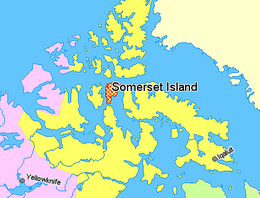
Boothia Peninsula is a large peninsula in Nunavut's northern Canadian Arctic, south of Somerset Island. The northern part, Murchison Promontory, is the northernmost point of mainland Canada.

Russell Island is an uninhabited island of the Arctic Archipelago in the Qikiqtaaluk Region of Nunavut, Canada. It is located in the Parry Channel, separated from the northern tip of Prince of Wales Island by the narrow Baring Channel. The western third of the island is separated from the other two thirds by a narrow lake and its outlet. At the northern end of the lake there is an isthmus just 1.1 km (0.68 mi) wide and this joins the two parts of the island. With a total area of 940 km2 (360 sq mi), it is the largest island offshore of Prince of Wales Island.
Lancaster Sound is a body of water in the Qikiqtaaluk Region, Nunavut, Canada. It is located between Devon Island and Baffin Island, forming the eastern entrance to the Parry Channel and the Northwest Passage. East of the sound lies Baffin Bay; to the west lies Viscount Melville Sound. Further west a traveller would enter the M'Clure Strait before heading into the Arctic Ocean.

Prince Regent Inlet is a body of water in Nunavut, Canada between the west end of Baffin Island and Somerset Island on the west. It opens north into Lancaster Sound and to the south merges into the Gulf of Boothia. The Arctic inlet's northern portion is approximately 40 mi (64 km) wide; the southern portion is approximately 65 mi (105 km) wide. It is deep throughout and there are no islands within the inlet.

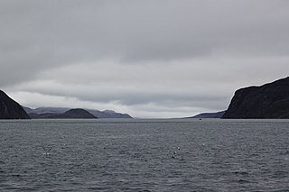
Fury and Hecla Strait is a narrow Arctic seawater channel located in the Qikiqtaaluk Region of Nunavut, Canada.
Bellot Strait is a strait in Nunavut that separates Somerset Island to its north from the Murchison Promontory of Boothia Peninsula to its south, which is the northernmost part of the mainland of the Americas. The two-kilometre-wide (1.2 mi) and 25-kilometre-long (16 mi) strait connects the Gulf of Boothia, Prince Regent Inlet, and Brentford Bay to its east with Peel Sound and Franklin Strait to its west.

The Parry Channel is a natural waterway through the central Canadian Arctic Archipelago. Its eastern two-thirds lie in the territory of Nunavut, while its western third lies in the Northwest Territories. It runs east to west, connecting Baffin Bay in the east with the Beaufort Sea in the west. Its eastern end is the only practical entrance to the Northwest Passage. Its western end would be a natural exit from the archipelago were it not filled with ice. The channel separates the Queen Elizabeth Islands to the north from the rest of Nunavut.
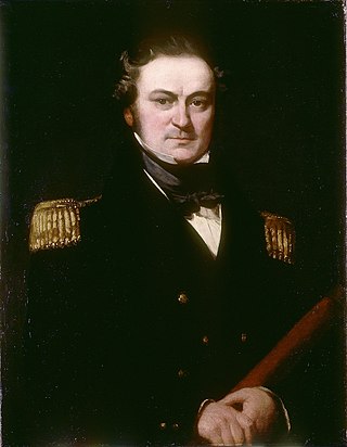
Captain Henry Parkyns Hoppner was an officer of the Royal Navy, Arctic explorer, draughtsman and artist. His career included two ill-fated voyages culminating in the loss of HMS Alceste in 1816 and HMS Fury in 1825.

Fort Ross is an abandoned former trading post on Somerset Island, in the Kitikmeot Region of Nunavut, Canada. Founded in 1937, it was the last trading post to be established by the Hudson's Bay Company. It was operational for only eleven years, being abandoned in 1948, as severe ice conditions in the surrounding waters made the site hard to reach and economically unviable.

Lori Idlout is a Canadian politician who has served as member of parliament for the riding of Nunavut in the House of Commons of Canada since 2021. She is a member of the New Democratic Party.