This article needs additional citations for verification .(December 2021) |
Altay | |
|---|---|
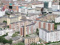 Altay City skyline in 2008 | |
 | |
 Altay Location of the city center in Xinjiang  Altay Altay (Xinjiang)  Altay Altay (China) | |
| Coordinates(Altay City government): 47°49′37″N88°07′51″E / 47.82694°N 88.13083°E | |
| Country | China |
| Autonomous region | Xinjiang |
| Prefecture | Altay |
| Municipal seat | Tuanjie Road Subdistrict |
| Area | |
| 11,400 km2 (4,400 sq mi) | |
| Elevation | 887 m (2,910 ft) |
| Population (2020) [1] | |
| 221,454 | |
| • Density | 19.4/km2 (50.3/sq mi) |
| • Urban (2016) [2] | 114,995 |
| • Rural (2016) [2] | 83,945 |
| Time zone | UTC+8 (China Standard [a] ) |
| Postal code | 836500 |
| Area code | 0906 |
| GDP (Nominal) | 2016 [2] |
| - Total | ¥6.483 billion US$1.007 billion |
| - per capita | ¥32.574 US$5.060 |
| Website | Altay City Government Website |
| Altay City | |||||||||||||
|---|---|---|---|---|---|---|---|---|---|---|---|---|---|
| Chinese name | |||||||||||||
| Chinese | 阿勒泰市 | ||||||||||||
| |||||||||||||
| Mongolian name | |||||||||||||
| Mongolian Cyrillic | Алтайхот | ||||||||||||
| Mongolian script | ᠠᠯᠲᠠᠢᠬᠣᠲᠠ | ||||||||||||
| |||||||||||||
| Uyghur name | |||||||||||||
| Uyghur | ئالتاي شەھىرى | ||||||||||||
| |||||||||||||
| Kazakh name | |||||||||||||
| Kazakh | التايقالاسى Алтайқаласы Altai qalası | ||||||||||||
Altay (also spelled Altai or Aletai) is a county-level city in Altay Prefecture within Ili Kazakh Autonomous Prefecture,in far Northern Xinjiang,China. The city centre is located on the banks of Kelan River.

