
An impact crater is a depression in the surface of a solid astronomical body formed by the hypervelocity impact of a smaller object. In contrast to volcanic craters, which result from explosion or internal collapse, impact craters typically have raised rims and floors that are lower in elevation than the surrounding terrain. Impact craters are typically circular, though they can be elliptical in shape or even irregular due to events such as landslides. Impact craters range in size from microscopic craters seen on lunar rocks returned by the Apollo Program to simple bowl-shaped depressions and vast, complex, multi-ringed impact basins. Meteor Crater is a well-known example of a small impact crater on Earth.

Iytwelepenty / Davenport Range, or Davenport Ranges National Park (Iytwellepenty), previously the Davenport Murchison National Park, is a national park in the Northern Territory of Australia about 1,033 kilometres (642 mi) south-east of the territorial capital of Darwin, occupying around 1,120 km2 (430 sq mi)s of the Davenport Range. It lies within the Davenport Murchison Ranges bioregion, an area of 58,050 km2 (22,410 sq mi), with a climate ranging from semiarid to subtropical.
The Sudbury Basin, also known as Sudbury Structure or the Sudbury Nickel Irruptive, is a major geological structure in Ontario, Canada. It is the third-largest known impact crater or astrobleme on Earth, as well as one of the oldest. The crater was formed 1.849 billion years ago in the Paleoproterozoic era.

Acraman impact structure is a deeply eroded impact crater in the Gawler Ranges of South Australia. Its location is marked by Lake Acraman, a circular ephemeral playa lake about 20 kilometres (12 mi) in diameter. The discovery of the impact structure and independent discovery of its ejecta were first reported in the journal Science in 1986. The evidence for impact includes the presence of shatter cones and shocked quartz in shattered bedrock on islands within Lake Acraman.
Foelsche is a partly buried impact structure, the eroded remnant of a former impact crater. It is situated about 85 km southeast of Borroloola in the Northern Territory, Australia, and named after the nearby Foelsche River. Although little of it is exposed at the surface, and no crater shaped topography is evident, the circular nature of the feature is obvious on aeromagnetic images, a factor that led to its discovery.
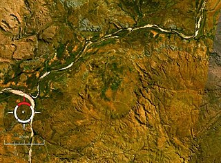
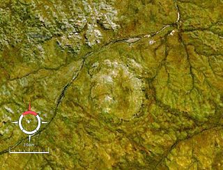
Goat Paddock is a 5 km-diameter near-circular bowl-shaped depression in a range of gently dipping Proterozoic sandstone in the Kimberley Region of northern Western Australia, 106 km west-southwest of Halls Creek. It is interpreted as an ancient meteorite impact crater, the evidence including breccia containing melted rocks, silica glass, shatter cones and shocked quartz. Drilling shows that the crater is filled with about 200 m of ancient lake sediments containing Early Eocene pollen, this age thus giving a minimum estimate for the age of the crater itself. The crater is not perfectly circular, but slightly elongated in a north–south direction, suggesting that the projectile struck at low angle from either the north or south.

Gosses Bluff is thought to be the eroded remnant of an impact crater. Known as Tnorala to the Western Arrernte people of the surrounding region, it is located in the southern Northern Territory, near the centre of Australia, about 175 km (109 mi) west of Alice Springs and about 212 km (132 mi) to the northeast of Uluru. It was named by Ernest Giles in 1872 after Australian explorer William Gosse's brother Henry, who was a member of William's expedition.

Goyder is an impact structure, the eroded remnant of a former impact crater. It is situated in Arnhem Land in the Northern Territory, Australia, and was named after the nearby Goyder River. The impact occurred into Mesoproterozoic sedimentary rocks of the McArthur Basin. The deformed area is exposed at the surface and marked by a 3 km diameter ring of fractured and faulted sandstone, which is interpreted as the eroded relic of a central uplift ; the original crater rim, long since removed by erosion, being estimated at approximately 9–12 km diameter. Evidence for an impact origin includes the presence of shatter cones and shocked quartz in outcrops of deformed sandstone at the center of the site.
Kelly West is a deeply eroded impact crater situated in the central Northern Territory, Australia. It was discovered during Government geological mapping and first reported in 1973, the evidence for impact coming principally from an abundance of shatter cones at the site.

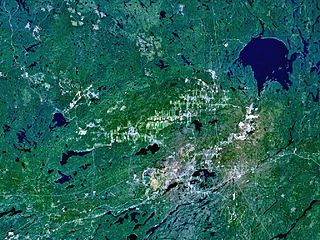
Keurusselkä is a lake in Central Finland between the towns of Keuruu to the north and Mänttä to the south. It covers an area of 117.3 km2 (45.3 sq mi). Its average depth is 6.4 m (21 ft) with a maximum depth of 40 m (130 ft). The surface lies at 105.4 m (346 ft) above sea level. The lake is 27 km (17 mi) long and is a part of the Kokemäenjoki water system. Keurusselkä gained international publicity in 2004 when a pair of amateur geologists discovered an ancient impact structure on the western shore of the lake.

Lawn Hill ‘crater’ refers to an Ordovician impact structure, the eroded remnant of a former impact crater, situated approximately 220 km north-north-west of Mount Isa in northwestern Queensland, Australia. The site is marked by an 18 km diameter ring of dolomite hills. The origin of this circular feature was uncertain until the discovery of shatter cones and shocked quartz from uplifted rocks at the centre was reported in 1987.

Liverpool is a meteorite impact crater situated in Arnhem Land within the Northern Territory, Australia. It was named after the nearby Liverpool River. Liverpool is remote and difficult to access. The crater has a raised, near-circular rim averaging about 1.6 km in diameter. It was first noticed by geologists during reconnaissance geological mapping in the 1960s, and although an impact origin was considered possible, this was not confirmed until a more detailed study was undertaken in 1970.

Shoemaker is an impact structure, the deeply eroded remnant of a former impact crater, situated in arid central Western Australia, about 100 km (62 mi) north-northeast of Wiluna. It is named in honour of planetary geologist Eugene Shoemaker.
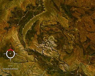
Spider is an impact structure, the deeply eroded remnant of a former impact crater, situated in the Kimberley region of northern Western Australia, 18 km east of the Mount Barnett Roadhouse on the Gibb River Road. Due to very rugged terrain the site is effectively inaccessible. The name is derived from the visually striking spider-like radiating ridges of quartzite prominently visible from the air or on satellite images.

Strangways is a large impact structure, the eroded remnant of a former impact crater, located in the Northern Territory of Australia about 65 kilometres (40 mi) east-south-east of the town of Mataranka. It was named after the nearby Strangways River. The location is remote and difficult to access. Its age has been determined as approximately 646 Ma.

Vepriai is the largest impact crater in Lithuania, named after the town of Vepriai located at its center. The crater is not exposed to the surface, having been eroded and covered by sedimentary rocks during the last glacial period.

The Vredefort impact structure is the largest verified impact structure on Earth. The crater, which has since been eroded away, has been estimated at 170–300 kilometres (110–190 mi) across when it was formed. The remaining structure, comprising the deformed underlying bedrock, is located in present-day Free State province of South Africa. It is named after the town of Vredefort, which is near its centre. The structure's central uplift is known as the Vredefort Dome. The impact structure was formed during the Paleoproterozoic Era, 2.023 billion years ago. It is the second-oldest known impact structure on Earth, after Yarrabubba.
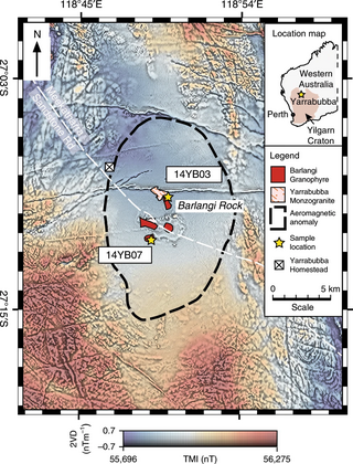
The Yarrabubba impact structure is the eroded remnant of an impact crater, situated in the northern Yilgarn Craton near Yarrabubba Station between the towns of Sandstone and Meekatharra, Mid West Western Australia. With an age of 2.229 billion years, it is the oldest known impact structure on Earth.

Glikson crater is an impact structure, the eroded remnant of a former impact crater, situated in the Little Sandy Desert of central Western Australia. A possible impact structure was first reported in 1997, and named after Australian geologist A. Y. Glikson, attention to the site being drawn by the presence of a prominent 14 km diameter ring-shaped aeromagnetic anomaly. The area within the ring contains sparse outcrop of uplifted and deformed Neoproterozoic sandstone, but is largely covered by sand dunes. The recent discovery of shatter cones and microscopic shock effects is reliable evidence for an impact origin. Deformation of the sandstone consistent with an impact origin extends out to a diameter of 19 km, which is the best estimate for the original diameter of the original crater. The ring-shaped aeromagnetic anomaly was probably caused by disruption of a horizontal layer of magnetic igneous rock, known as a sill, by the impact event. Nearby outcrops of dolerite have been dated at 508 ± 5 Ma (Middle Cambrian), and if this is the same rock causing the aeromagnetic anomaly, then the impact must be younger, probably of Paleozoic age.
The Santa Fe impact structure is an eroded remnant of a bolide impact crater in the Sangre de Cristo Mountains northeast of Santa Fe, New Mexico. The discovery was made in 2005 by a geologist who noticed shatter cones in the rocks in a decades-old road cut on New Mexico State Road 475 between Santa Fe and Hyde Memorial State Park. Shatter cones are a definitive indicator that the rocks had been exposed to a shock of pressures only possible in a meteor impact or a nuclear explosion.


