An impact crater is a circular depression in the surface of a solid astronomical object formed by the hypervelocity impact of a smaller object. In contrast to volcanic craters, which result from explosion or internal collapse, impact craters typically have raised rims and floors that are lower in elevation than the surrounding terrain. Lunar impact craters range from microscopic craters on lunar rocks returned by the Apollo program and small, simple, bowl-shaped depressions in the lunar regolith to large, complex, multi-ringed impact basins. Meteor Crater is a well-known example of a small impact crater on Earth.

An impact event is a collision between astronomical objects causing measurable effects. Impact events have been found to regularly occur in planetary systems, though the most frequent involve asteroids, comets or meteoroids and have minimal effect. When large objects impact terrestrial planets such as the Earth, there can be significant physical and biospheric consequences, as the impacting body is usually traveling at several kilometres a second, though atmospheres mitigate many surface impacts through atmospheric entry. Impact craters and structures are dominant landforms on many of the Solar System's solid objects and present the strongest empirical evidence for their frequency and scale.
Bedout, or more specifically the Bedout High, is a geological and geophysical feature centered about 250 km off the northwestern coast of Australia in the Canning and overlying Roebuck basins. Although not obvious from sea floor topography, it is a roughly circular area about 30 km in diameter where older rocks have been uplifted as much as 4 km towards the surface and may mark the centre of a very large buried impact crater up to 250 km in diameter. The Bedout High was penetrated by two petroleum exploration wells in the 1970s and 1980s. It is named after nearby Bedout Island.

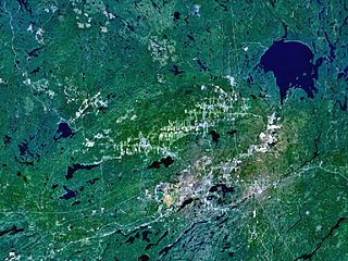
Manicouagan Reservoir is an annular lake in central Quebec, Canada, covering an area of 1,942 km2 (750 sq mi). The lake island in its centre is known as René-Levasseur Island, and its highest point is Mount Babel. The structure was created 214 (±1) million years ago, in the Late Triassic, by the impact of a meteorite 5 km (3 mi) in diameter. The lake and island are clearly seen from space and are sometimes called the "eye of Quebec". The lake has a volume of 137.9 km3 (33.1 cu mi).
The Sudbury Basin, also known as Sudbury Structure or the Sudbury Nickel Irruptive, is a major geological structure in Ontario, Canada. It is the third-largest known impact crater or astrobleme on Earth, as well as one of the oldest. The crater was formed 1.849 billion years ago in the Paleoproterozoic era.
The Araguainha crater or Araguainha dome is an impact crater on the border of Mato Grosso and Goiás states, Brazil, between the villages of Araguainha and Ponte Branca. With a diameter of 40 kilometres (25 mi), it is the largest known impact crater in South America.
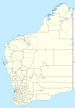
Connolly Basin is a 9 km-diameter impact crater located in the Gibson Desert of central Western Australia. It lies adjacent to the Talawana Track 45 km west of the junction with the Gary Highway, but is difficult to access due to the remoteness of the area. It was originally thought to be a diapir ; an impact origin was first proposed in 1985.,

Shoemaker is an impact structure, the deeply eroded remnant of a former impact crater, situated in arid central Western Australia, about 100 km (62 mi) north-northeast of Wiluna. It is named in honour of planetary geologist Eugene Shoemaker.
Tookoonooka is a large meteorite impact structure (astrobleme) situated in South West Queensland, Australia. It lies deeply buried within Mesozoic sedimentary rocks of the Eromanga Basin and is not visible at the surface.

The Vredefort impact structure is the largest verified impact structure on Earth. The crater, which has since been eroded away, has been estimated at 170–300 kilometres (110–190 mi) across when it was formed. The remaining structure, comprising the deformed underlying bedrock, is located in present-day Free State province of South Africa. It is named after the town of Vredefort, which is near its centre. The structure's central uplift is known as the Vredefort Dome. The impact structure was formed during the Paleoproterozoic Era, 2,023 million years ago. It is the second-oldest known impact structure on Earth, after Yarrabubba.
Wilkes Land crater is an informal term that may apply to two separate cases of conjectured giant impact craters hidden beneath the ice cap of Wilkes Land, East Antarctica. These are separated below under the heading Wilkes Land anomaly and Wilkes Land mascon (mass concentration), based on terms used in their principal published reference sources.

The Lac Wiyâshâkimî, also called the Clearwater Lakes in English and Allait Qasigialingat by the Inuit, are a pair of annular lakes and possible impact craters on the Canadian Shield in Quebec, Canada, near Hudson Bay.

Glikson crater is an impact structure, the eroded remnant of a former impact crater, situated in the Little Sandy Desert of central Western Australia. A possible impact structure was first reported in 1997, and named after Australian geologist A. Y. Glikson, attention to the site being drawn by the presence of a prominent 14 km diameter ring-shaped aeromagnetic anomaly. The area within the ring contains sparse outcrop of uplifted and deformed Neoproterozoic sandstone, but is largely covered by sand dunes. The recent discovery of shatter cones and microscopic shock effects is reliable evidence for an impact origin. Deformation of the sandstone consistent with an impact origin extends out to a diameter of 19 km, which is the best estimate for the original diameter of the original crater. The ring-shaped aeromagnetic anomaly was probably caused by disruption of a horizontal layer of magnetic igneous rock, known as a sill, by the impact event. Nearby outcrops of dolerite have been dated at 508 ± 5 Ma (Middle Cambrian), and if this is the same rock causing the aeromagnetic anomaly, then the impact must be younger, probably of Paleozoic age.
The Carnarvon Basin is a geological basin located in the north west of Western Australia which extends from the Dampier Archipelago to the Murchison bioregion, and is the main geological feature that makes up the North West Shelf. The onshore part of the Carnarvon Basin covers about 115,000 km2 and the offshore part covers approximately 535,000 km2 with water depths up to 3,500 metres. It is separated into two major areas - the Northern Carnarvon Basin, and the Southern Carnarvon Basin.

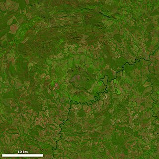
The Siljan Ring is a prehistoric impact structure in Dalarna, central Sweden. It is one of the 15 largest known impact structures on Earth and the largest in Europe, with a diameter of about 52 kilometres (32 mi). The impact that created the Siljan Ring occurred when a meteorite collided with the Earth's surface during the Devonian period. The exact timing of the impact has been estimated at 376.8 ± 1.7 Ma or at 377 ± 2 Ma. This impact has been proposed as a cause of the first Devonian extinction, the Kellwasser Event or Late Frasnian extinction, due to it being believed by some researchers to coincide around the time of the Kellwasser event at 376.1 Ma ± 1.6 Ma, although the timing of this extinction event has since been pushed forward to 371.93–371.78 Ma. The effects of the impact can clearly be seen in the bedrock in the area. The Cambrian, Ordovician and Silurian sedimentary rocks deformed by the impact are rich in fossils.
The East Warburton Basin in South Australia is the site of a hypothesised large impact crater of the Carboniferous period. The subterranean structure lies buried at a depth of ~4 km, and measures a minimum of 200 km in diameter. For comparison, the Chicxulub crater, which caused the Cretaceous–Paleogene extinction event, is about 180 km in diameter. The East Warburton crater is adjacent to the West Warburton crater, which is also around 200 km in diameter. Combined, they make up the largest known impact zone on Earth, but individually, are smaller than the largest in the world, the 300 km wide Vredefort impact structure in South Africa. The Warburton craters formed when an asteroid or comet, on a collision course with Earth, split into two main pieces and impacted the Australian continent, then part of the Gondwanan supercontinent.
Reidite is a rare polymorph of ZrSiO4 created when zircon experiences high pressure and temperature. Reidite is denser than zircon and has the same crystal structure as scheelite. All natural occurrences of reidite are associated with meteorite impact events.