Amrapur, Jamnagar district

Last updated

See Amrapur for namesakes
Amrapur [1] [2]
Village
India Gujarat location map.svg
Red pog.svg
Amrapur [7] [8]
Location in Gujarat, India
India location map.svg
Red pog.svg
Amrapur [13] [14]
Amrapur [15] [16] (India)
Coordinates: 22°22′17″N70°23′11″E / 22.371262°N 70.38633°E / 22.371262; 70.38633
CountryFlag of India.svg  India
State Gujarat
District Jamnagar
Population
 (2001)
  Total250
Languages
  Official Gujarati, Hindi
Time zone UTC+5:30 (IST)
Postal Index Number
361130
Vehicle registration GJ
Website gujaratindia.com

Amrapur is a town and former petty princely state in Jamnagar, in Kathiawar, Gujarat state, western India.

Contents

Village

Most inhabitants are farmers. Some of them are connected with animal husbandry. Mr Vijaybhai Borsadiya is currently sarpanch of the village‍.

Location

Amrapur is surrounded on three sides by a dam. Amrapur is located at 22°22′17″N70°23′11″E / 22.371262°N 70.38633°E / 22.371262; 70.38633 On Globe. [17] The road to it is from Kalavad to Ranuja, Dhutarpur, Sumary,[ clarification needed ] Kharavedha, Amrapur.

Statistics

History

Amrapur was the seat of an eponymous non-salute princely state in Halar prant, comprising it and another village on Saurashtra peninsula in present Gujarat, western India. It was ruled by Muslim Chieftains of a Shaikh family.

It had a population of 1210 in 1901, yielding a state revenue of 8,000 Rupees (all from land, 1903–04) and paying 511 Rupees to the British.

Related Research Articles

<span class="mw-page-title-main">Nawanagar State</span> Former princely state in Gujarat, India

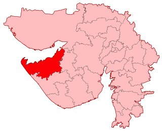
Nawanagar was an Indian princely state in the historical Halar region, located on the southern shores of the Gulf of Kutch. It was ruled by the Jadeja Rajput dynasty and became a part of newly formed India. Its capital city was Nawanagar city, now known as Jamnagar. It had an area of 3,791 square miles (9,820 km2) and a population estimated at 336,779 in 1901. Its rulers, who use the title of "Jam Saheb" are of the same clan as the Rao of Kutch. They were entitled to a 13-gun salute. The state flag was a rectangular red flag with a white elephant, near and facing the hoist. During the British, the state was part of the Kathiawar Agency, within the Gujarat Division of Bombay Presidency.

<span class="mw-page-title-main">Jamnagar Lok Sabha constituency</span> Lok Sabha Constituency in Gujarat

Jamnagar Lok Sabha constituency is one of the 26 Lok Sabha (parliamentary) constituencies in Gujarat state in western India.

Jamnagar North is one of the 182 Legislative Assembly constituencies of Gujarat state in India. It is part of Jamnagar district and it came into existence after 2008 delimitation.

Jamnagar South is one of the 182 Legislative Assembly constituencies of Gujarat state in India. It is part of Jamnagar district and covers a major area of Jamnagar Municipal Corporation.

Jamjodhpur is one of the 182 Legislative Assembly constituencies of Gujarat state in India. It is part of Jamnagar district.

<span class="mw-page-title-main">Morvi State</span> Princely state of India

Morvi State, also spelled as Morvee State or Morbi State, was a princely salute state in the historical Halar prant (district) of Kathiawar during the British Raj.

Chamardi is a large village located within the Vallabhipur Taluka township of the Bhavnagar district (Gujarat), in West India. It was formerly a part of Rajput princely state.

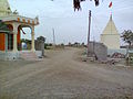
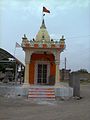
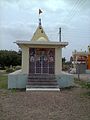
Nandpur is a small village in Jamnagar, Gujarat, India. The road to it is from Kalavad to Ranuja, Dhutarpur, Bajrangpur, Vijaypur, Bharatpur Nandpur and from Dhrol to Falla, Ranjitpar, Jamwanthali, Nandpur. Most people there are farmers. Some of them are connected with animal husbandry.

(Bhalgam) Baldhoi is a village and former non-salute princely state in Gujarat, western India.

Kamadhia is a town and former princely state in the western Indian state of Gujarat.

Vadal or Wadal is a village and petty former princely state on Saurashtra peninsula in Gujarat, western India.

Alampur is a town and former Rajput petty princely state on Saurashtra peninsula, in Gujarat, western India.

Amrapur may refer to the following places in India :

Gigasaran is a village and former petty princely state in Gujarat, western India.

Kathrota is a village and former non-salute princely state on Saurashtra peninsula in Gujarat, western India.

Kotda Nayani is a village and former non-salute princely state on Saurastra peninsula in Gujarat, western India.

Lakhapadar is a village and former non-salute princely state on the Saurashtra peninsula in Gujarat, western India.

Sahuka is a village and former Rajput princely state on Saurashtra peninsula, in Gujarat state, western India.

Chhalala is a village in Chuda Taluka of Surendranagar district, Gujarat, India. It was formerly Rajput princely state.

The Chitravav (Divani) is a village in Rajkot Taluka of Rajkot district, Gujarat, India and former petty Rajput princely state.

References

  1. "Archived copy". Archived from the original on 2 February 2020. Retrieved 20 October 2013.{{cite web}}: CS1 maint: archived copy as title (link)
  2. "Archived copy". Archived from the original on 20 January 2019. Retrieved 12 March 2014.{{cite web}}: CS1 maint: archived copy as title (link)
  3. "Archived copy". Archived from the original on 2 February 2020. Retrieved 20 October 2013.{{cite web}}: CS1 maint: archived copy as title (link)
  4. "Archived copy". Archived from the original on 20 January 2019. Retrieved 12 March 2014.{{cite web}}: CS1 maint: archived copy as title (link)
  5. "Archived copy". Archived from the original on 2 February 2020. Retrieved 20 October 2013.{{cite web}}: CS1 maint: archived copy as title (link)
  6. "Archived copy". Archived from the original on 20 January 2019. Retrieved 12 March 2014.{{cite web}}: CS1 maint: archived copy as title (link)
  7. "Archived copy". Archived from the original on 2 February 2020. Retrieved 20 October 2013.{{cite web}}: CS1 maint: archived copy as title (link)
  8. "Archived copy". Archived from the original on 20 January 2019. Retrieved 12 March 2014.{{cite web}}: CS1 maint: archived copy as title (link)
  9. "Archived copy". Archived from the original on 2 February 2020. Retrieved 20 October 2013.{{cite web}}: CS1 maint: archived copy as title (link)
  10. "Archived copy". Archived from the original on 20 January 2019. Retrieved 12 March 2014.{{cite web}}: CS1 maint: archived copy as title (link)
  11. "Archived copy". Archived from the original on 2 February 2020. Retrieved 20 October 2013.{{cite web}}: CS1 maint: archived copy as title (link)
  12. "Archived copy". Archived from the original on 20 January 2019. Retrieved 12 March 2014.{{cite web}}: CS1 maint: archived copy as title (link)
  13. "Archived copy". Archived from the original on 2 February 2020. Retrieved 20 October 2013.{{cite web}}: CS1 maint: archived copy as title (link)
  14. "Archived copy". Archived from the original on 20 January 2019. Retrieved 12 March 2014.{{cite web}}: CS1 maint: archived copy as title (link)
  15. "Archived copy". Archived from the original on 2 February 2020. Retrieved 20 October 2013.{{cite web}}: CS1 maint: archived copy as title (link)
  16. "Archived copy". Archived from the original on 20 January 2019. Retrieved 12 March 2014.{{cite web}}: CS1 maint: archived copy as title (link)
  17. "22°22'16.5"N 70°23'10.8"E".