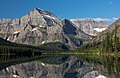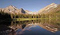
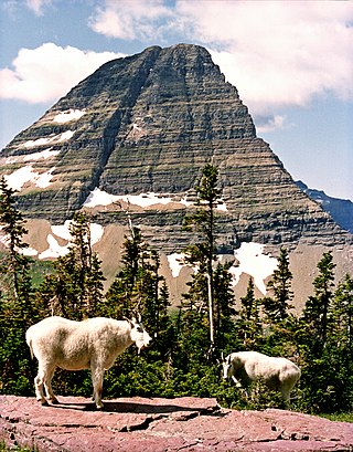
Mount Wilbur is located in the Lewis Range, Glacier National Park in the U.S. state of Montana. Plainly visible from the region of Many Glacier, the peak rises over 4,500 feet (1,372 m) above Swiftcurrent Lake and is a steep pyramid on three sides. The west slopes of the peak join to ridges along the continental divide. Much of the climbing routes are rated at class 4 to 5, with some only used once. The sedimentary rock of the mountains makes for often poor anchoring points and enhances the difficulty. A cirque on the north slopes of the mountain shelters Iceberg Lake, a popular hiking destination from Many Glacier. The mountain was named by George Bird Grinnell in 1885, for Edward R. Wilbur of New York, one of Grinnell's partners in the Forest and Stream Publishing Company, and both men were founders of the Audubon Society.

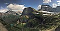
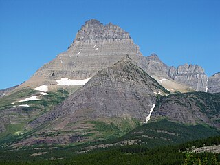
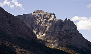
Mount Gould is a peak on the Continental Divide in Glacier National Park, Montana, United States. It is the highest point of the Garden Wall, a distinctive ridge of the Lewis Range. It is most notable for its huge, steep east face, which drops 4,000 ft (1,220 m) in only one-half mile (0.8 km). This face provides a backdrop to Grinnell Lake, and is often photographed.

Ipasha Peak is located in the Lewis Range, Glacier National Park in the U.S. state of Montana. Ipasha Peak is 1.29 miles (2.08 km) south of Mount Merritt and is in the northeastern section of Glacier National Park. Ahern Glacier is located on the southeastern slopes of the mountain while the Ipasha Glacier is to the southwest of the peak. Helen Lake lies almost 4,500 feet (1,400 m) below the summit of Ipasha Peak to the southeast.
Little Chief Mountain is located in the Lewis Range, Glacier National Park in the U.S. state of Montana. Little Chief Mountain is easily seen from the Going-to-the-Sun Road, rising to the south of Saint Mary Lake. Little Chief Mountain was named in 1887 by George Bird Grinnell for his friend, Frank North, U.S. Army. "Little Chief" was his Pawnee name, given to him by his Pawnee Scouts.
Mahtotopa Mountain is located in the Lewis Range, Glacier National Park in the U.S. state of Montana. Mahtotopa Mountain rises to the south above Saint Mary Lake midway between Red Eagle Mountain and Little Chief Mountain and can be easily seen from the Going-to-the-Sun Road to the southwest of Rising Sun. Originally named Four Bears Mountain by George Bird Grinnell in 1885, the name was changed in 1932 to Mahtotopa. Mahtotopa is an incorrect spelling of "Mato-tope", the Mandan chief known as Four Bears. Mato-tope was a grandfather of Joe Kipp, a hunting companion of Grinnell.

Mount Henkel is located in the Lewis Range, Glacier National Park in the U.S. state of Montana. Kennedy Lake is just to the north of the mountain.
Bearhat Mountain is located in the Lewis Range, Glacier National Park in the U.S. state of Montana. Bearhat Mountain is immediately west of Hidden Lake. The mountain was named after a Kootenai Native American, and was officially adopted by the U.S. Board on Geographic Names in 1932.

Mount Cannon is located in the Lewis Range, Glacier National Park in the U.S. state of Montana. Formerly called Goat Mountain it was renamed for the leading physiologist Dr. Walter Bradford Cannon and his wife Cornelia, who made the first recorded ascent of the mountain in 1901.

Olson Mountain, also known as Mount Olson, is a 7,913-foot-elevation mountain summit located in the Livingston Range, of Glacier National Park in the U.S. state of Montana. Olson Mountain rises more than 3,700 feet (1,100 m) above the western shore of Waterton Lake. The mountain was named for a surveyor on the International Boundary Survey, with the name officially adopted in 1929. The nearest higher peak is Campbell Mountain, 1.13 miles (1.82 km) to the north, and Citadel Peaks is two miles to the south. Precipitation runoff from the mountain drains into Olson Creek before it empties to Waterton Lake.

Stanton Mountain is a 7,750 feet (2,360 m) mountain summit located in the Livingston Range, of Glacier National Park in the U.S. state of Montana. Stanton Mountain rises more than 4,500 feet (1,400 m) above the northern shore of Lake McDonald. The mountain's name refers to Mrs. Lottie Stanton who lived near the west side of the park in the late 1800s, and with her husband operated a livery stable in historic Demersville. She was a pioneering woman who followed the construction camps during the railroad building days. The mountain's name was officially adopted in 1929. In the late 1800s it was known as Mt. Lottie Stanton. The nearest higher peak is Mount Vaught, 1.38 miles (2.22 km) to the northeast. Precipitation runoff from the mountain drains into tributaries of the Flathead River.
Little Matterhorn is a 7,886-foot elevation mountain summit located in the Lewis Range, of Glacier National Park in the U.S. state of Montana. The nearest higher peak is Edwards Mountain, 0.9 miles (1.4 km) to the south. Precipitation runoff from the mountain drains into creeks which empty into Lake McDonald. Based on the Köppen climate classification, Little Matterhorn has an alpine climate characterized by long, usually very cold winters, and short, cool to mild summers. Winter temperatures can drop below −10 °F with wind chill factors below −30 °F.

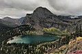
The Dragons Tail is an 8,580-foot (2,620-meter) elevation ridge located in the Lewis Range, of Glacier National Park in the U.S. state of Montana. It is situated on the Continental Divide, on the border shared by Flathead County and Glacier County. Topographic relief is significant as the north aspect rises 2,200 feet above Hidden Lake in one-half mile, and the west aspect rises nearly 4,700 feet above Avalanche Lake in two miles. It can be seen from the Hidden Lake overlook along with its nearest higher neighbor, Bearhat Mountain, 1.27 miles (2.04 km) to the northwest.

Red Crow Mountain is a 7,891-foot-elevation (2,405-meter) mountain summit located in Glacier National Park in the U.S. state of Montana. The summit is set on the border shared by Flathead County and Glacier County. It is situated on the Continental Divide so precipitation runoff from the east side of the mountain drains into Railroad Creek which is part of the Two Medicine River watershed, and the west side drains to Ole Creek, which is a tributary of Middle Fork Flathead River. It is set in the Lewis Range, 6.5 miles southwest of East Glacier Park Village. Topographic relief is significant as the east aspect rises approximately 2,000 feet in one mile. The nearest higher neighbor is Calf Robe Mountain 1.2 mile to the southeast, with Firebrand Pass forming the saddle between these two peaks.

Haystack Butte is a 7,486-foot-elevation (2,282-meter) summit located in the Lewis Range, of Glacier National Park in the U.S. state of Montana. It is situated one mile west of the Continental Divide, in Flathead County, above the Weeping Wall on its south slope. Topographic relief is significant as the west aspect rises 3,900 feet above McDonald Creek in less than 1.5 mile. It can be seen from Logan Pass, and from Going-to-the-Sun Road which traverses the west and south slopes of the peak. The nearest higher neighbor is Mount Gould, 1.07 miles (1.72 km) to the northeast. Climbing access is via the Highline Trail. This geographical feature's descriptive name was on maps as early as 1904, and was officially adopted March 6, 1929, by the United States Board on Geographic Names

Clyde Peak is an 8,610-foot-elevation (2,620-meter) mountain summit located in Glacier National Park in the U.S. state of Montana. The mountain straddles the border shared by Flathead County and Glacier County. It is situated on the Continental Divide so precipitation runoff from the west side of the mountain drains into Thompson Creek which is part of the Middle Fork Flathead River watershed, and the east side drains into headwaters of Red Eagle Creek, which flows to Red Eagle Lake, thence Saint Mary Lake. It is set in the Lewis Range, and the nearest higher neighbor is Mount Logan 1.44 mile to the northwest. Topographic relief is significant as the southwest aspect rises approximately 4,000 feet in one mile.
Elk Mountain is a 7,835-foot-elevation (2,388-meter) mountain summit located in Flathead County in the U.S. state of Montana. It is situated in the southern tip of Glacier National Park, in the Lewis Range, about four miles to the west side of the Continental Divide. US Highway 2 and the Hi-Line Subdivision of the BNSF Railway traverse the southern base of this mountain, approximately four miles west of Marias Pass. Topographic relief is significant as the northwest aspect rises 3,400 feet above Ole Creek in one mile. The nearest higher neighbor is Sheep Mountain 2.7 miles to the north-northwest. The mountain's name first appeared on a 1914 USGS map, and was officially adopted in 1929 by the United States Board on Geographic Names. The summit is the site of a former fire lookout that was built in the 1930s, and removed in 1963.
Scenic Point is a 7,522-foot-elevation (2,293-meter) mountain summit located in the Two Medicine area of Glacier National Park, in Glacier County, Montana, United States. It is situated in the Lewis Range, six miles northwest of East Glacier Park Village, and approximately seven miles east of the Continental Divide, with precipitation runoff from the mountain draining into the Two Medicine River watershed. Topographic relief is significant as the north aspect rises over 2,600 feet above Lower Two Medicine Lake in one mile. Access to the summit is via the Continental Divide National Scenic Trail which traverses the upper slopes of this mountain. The trail to Scenic Point was constructed by the Great Northern Railway, and the summit once hosted a locomotive bell, a Swiss Alps tradition. The mountain's name was officially adopted in 1929 by the United States Board on Geographic Names.

Spot Mountain is a 7,831-foot-elevation (2,387-meter) mountain summit located in the Two Medicine area of Glacier National Park, in Glacier County, Montana, United States. It is situated in the Lewis Range, nine miles northwest of East Glacier Park Village, and approximately five miles east of the Continental Divide. Precipitation runoff from the mountain drains into tributaries of Cut Bank Creek and Two Medicine River, which merge to form the Marias River. Topographic relief is significant as the south aspect rises nearly 3,000 feet above Lower Two Medicine Lake in two miles. The mountain's name was officially adopted in 1929 by the United States Board on Geographic Names.

Citadel Peaks is a mountain ridge located in the Goat Haunt area of Glacier National Park, in Glacier County of the U.S. state of Montana. This arête with a row of sharp points is part of the Livingston Range, and is approximately four miles east of the Continental Divide. Neighbors include Olson Mountain, two miles (3.2 km) to the north, Mount Cleveland four miles (6.4 km) to the east, and Kootenai Peak 2.7 miles (4.3 km) to the south. Topographic relief is significant as Citadel Peaks rises over 3,800 feet above Waterton Lake in less than two miles, and 3,000 feet above Lake Janet in one mile. Precipitation runoff from the mountain drains to the south end of Waterton Lake. The first ascent of Citadel Spire, a major pinnacle on the ridge, was made in 1967 by Jerry Kanzler, Jim Kanzler, Ray Martin, and Clare Pogreba. This geographical feature's name was officially adopted in 1929 by the United States Board on Geographic Names. To the Pikuni people, Citadel Peaks is known as "Ataniawxis", meaning "The Needles".

Porcupine Ridge is a prominent mountain ridge located in the Goat Haunt area of Glacier National Park, in Glacier County of the U.S. state of Montana. This mountain is part of the Livingston Range, and is situated 1.5 mile east of the Continental Divide. Topographic relief is significant as the summit rises approximately 3,900 feet above Lake Frances in one mile, and nearly 5,000 feet above Waterton Lake in five miles. Precipitation runoff from the mountain drains to the Waterton River via Olson and Valentine Creeks. This geographical feature's name was officially adopted in 1911 by the United States Board on Geographic Names.