Glacier County, Montana

Last updated

Glacier County
Glacier County Courthouse July 2020.jpg
Glacier County Courthouse in Cut Bank
Map of Montana highlighting Glacier County.svg
Location within the U.S. state of Montana
Montana in United States.svg
Montana's location within the U.S.
Coordinates: 48°42′N113°01′W / 48.7°N 113.02°W / 48.7; -113.02
CountryFlag of the United States.svg United States
StateFlag of Montana.svg  Montana
Founded1919
Named for The glaciers in Glacier National Park
Seat Cut Bank
Largest cityCut Bank
Area
  Total3,037 sq mi (7,870 km2)
  Land2,996 sq mi (7,760 km2)
  Water41 sq mi (110 km2)  1.40%
Population
 (2020)
  Total13,778
  Estimate 
(2022)
13,681 Decrease2.svg
  Density4.5/sq mi (1.8/km2)
Time zone UTC−7 (Mountain)
  Summer (DST) UTC−6 (MDT)
Congressional district 1st
Website www.glaciercountymt.org
  • Montana county number 38

Glacier County is located in the U.S. state of Montana. As of the 2020 census, the population was 13,778. [1] The county is located in northwestern Montana between the Great Plains and the Rocky Mountains, known to the Blackfeet as the "Backbone of the World". The county is geographically and culturally diverse and includes the Blackfeet Indian Reservation, Glacier National Park, and Lewis and Clark National Forest. The county is bordered by 75 miles of international boundary with two ports of entry (Piegan and Del Bonita) open year-round and one seasonal (Chief Mountain) international border crossing into Alberta, Canada.

Contents

Settlements

Several small unincorporated communities, one incorporated town, and one incorporated city are located within the county.

Cut Bank, the county seat [2] with a population of around 3,000, is located in eastern Glacier County, on the edge of the Great Plains. Cut Bank arose from the railway [3] and agricultural needs of the surrounding area, and was fostered by an oil boom in the 1920s. [4] The town's diverse population is a result of this settlement. Town resources and services include a hospital and clinic, an historic airport (with regional and international connections), a nine-hole golf course, and a municipal swimming pool. Nearby historical sites from the Lewis and Clark expedition, among other historic and prehistoric locations, can be visited. The Glacier County Museum has a collection of archaeological artifacts, historic buildings, community memorabilia, and a comprehensive archive of early area history and individuals, including a large collection of data on Blackfeet history.

Browning is the home and government seat of the Blackfeet Tribe. [5] The incorporated portion of Browning, at 1,400 residents, does not reflect the total population of around 7,000 in the wider community, largely representative of the Blackfeet Tribe on a part of their ancestral homeland, which dates back over 400 years. Town businesses and resources include a federal building, community college, Native American Museum and Heritage Center, casino, fairgrounds, racetrack, and Native American camp area that hosts an annual Native American celebration and powwow. Many events are held in this area during the summer months. Blackfeet tribal fishing, hunting and recreational permits, along with guide and tour services to blue-ribbon trout fishing (and other recreational opportunities), can be found there.

Babb is a small, unincorporated farming and ranching community on the Blackfeet Indian Reservation. The community experiences a large influx of tourists in the summer months, as it is the gateway to the Many Glacier area of Glacier National Park. Community infrastructure includes one school, a US post office, a fire station, and a general store as well as a motel, gas station, several restaurants, and two churches. Nearby attractions include the aforementioned Glacier National Park, the historic Many Glacier Hotel, the St. Mary River and Irrigation Canal, and Chief Mountain, as well as the Piegan and Chief Mountain border crossings with Alberta, Canada.

East Glacier Park Village, a small winter community, grows in the summertime with many visitors and the summer workforce, hailing from all parts of the globe to meet the needs of the larger population. It is the site of the largest of Glacier Park's historic hotels and its fleet of "red buses". It has a nine-hole golf course, campgrounds, trail rides, boat rides, and native interpretive tours.

St. Mary is an unincorporated community on the western border of the Blackfeet Native American Reservation, located adjacent to Glacier National Park. The village is the eastern terminus of the Going-to-the-Sun Road which bisects the park east-to-west at a length of 53 miles (85 km). Fewer than 50 people reside in the village year-round; however, the population increases tenfold on a busy summer evening. It has several lodges, restaurants and cafés, a small grocery store, two gas stations and campgrounds. A large housing area for National Park Service personnel is located adjacent to the village, within the park. U.S. Route 89 passes through the village, which lies between Saint Mary Lake in Glacier National Park and Lower St. Mary Lake on the Blackfeet Native American Reservation.

Starr School is a census-designated place (CDP) in Glacier County. The population was 252 at the 2010 census.

Geography

According to the United States Census Bureau, the county has a total area of 3,037 square miles (7,870 km2), of which 2,996 square miles (7,760 km2) is land and 41 square miles (110 km2) (1.3%) is water. [6] About 71% of the county's land area lies within the Blackfeet Indian Reservation. Another 21% lies within Glacier National Park in western Glacier County.

Adjacent counties

National protected areas

Politics

Owing largely to its majority Native American population, Glacier County generally votes Democratic, in contrast with most other rural Montana counties, which trend Republican.

United States presidential election results for Glacier County, Montana [7]
Year Republican Democratic Third party
No.%No.%No.%
2020 1,88433.54%3,61064.27%1232.19%
2016 1,62031.92%3,12161.50%3346.58%
2012 1,41531.76%2,92465.63%1162.60%
2008 1,45129.19%3,42368.86%971.95%
2004 1,82840.07%2,64157.89%932.04%
2000 1,70941.44%2,21153.61%2044.95%
1996 1,27031.01%2,29255.97%53313.02%
1992 1,22228.27%2,07648.02%1,02523.71%
1988 1,72843.16%2,15153.72%1253.12%
1984 2,22850.24%2,16748.86%400.90%
1980 2,28355.78%1,39434.06%41610.16%
1976 1,89250.81%1,75547.13%772.07%
1972 2,14356.11%1,46938.47%2075.42%
1968 1,64344.76%1,72346.94%3058.31%
1964 1,45839.44%2,21859.99%210.57%
1960 1,77543.95%2,26055.95%40.10%
1956 2,05452.99%1,82247.01%00.00%
1952 2,06154.68%1,69845.05%100.27%
1948 1,23835.29%2,23863.80%320.91%
1944 1,22836.34%2,14263.39%90.27%
1940 1,35235.96%2,39963.80%90.24%
1936 78123.92%2,45375.13%310.95%
1932 70228.78%1,71770.40%200.82%
1928 84746.39%97653.45%30.16%
1924 58641.68%51136.34%30921.98%
1920 1,29769.14%53128.30%482.56%

Demographics

Historical population
CensusPop.Note
1920 4,178
1930 5,29726.8%
1940 9,03470.5%
1950 9,6456.8%
1960 11,56519.9%
1970 10,783−6.8%
1980 10,628−1.4%
1990 12,12114.0%
2000 13,2479.3%
2010 13,4471.5%
2020 13,7782.5%
2022 (est.)13,681 [8] −0.7%
U.S. Decennial Census [9]
1790–1960, [10] 1900–1990, [11]
1990–2000, [12] 2010–2020 [1]

2020 census

As of the 2020 census, there were 13,778 people living in the county.[ citation needed ]

2010 census

As of the 2010 census, there were 13,399 people, 4,361 households, and 3,088 families residing in the county. The population density was 4.5 inhabitants per square mile (1.7/km2). There were 5,348 housing units at an average density of 1.8 per square mile (0.69/km2). The racial makeup of the county was 65.6% Native American, 31.1% white, 0.2% Asian, 0.1% black or African American, 0.2% from other races, and 2.8% from two or more races. Those of Hispanic or Latino origin made up 1.8% of the population. In terms of ancestry, 13.6% were German, 7.2% were Irish, 5.6% were Norwegian, and 1.4% were American.

Of the 4,361 households, 44.0% had children under the age of 18 living with them, 42.8% were married couples living together, 19.1% had a female householder with no husband present, 29.2% were non-families, and 24.9% of all households were made up of individuals. The average household size was 2.91 and the average family size was 3.49. The median age was 31.7 years.

The median income for a household in the county was $38,075 and the median income for a family was $44,397. Males had a median income of $31,700 versus $30,594 for females. The per capita income for the county was $17,053. About 21.4% of families and 25.4% of the population were below the poverty line, including 35.0% of those under age 18 and 12.9% of those age 65 or over.

Communities

The sign for Glacier County on U.S. Route 2 Glacier County Montana Sign Looking East US2.jpg
The sign for Glacier County on U.S. Route 2

City

Census-designated places

Unincorporated communities

Education

High school districts include: [25]

Elementary school districts include: [25]

See also

Related Research Articles

<span class="mw-page-title-main">Piegan Blackfeet</span> Native American tribe

The Piegan are an Algonquian-speaking people from the North American Great Plains. They are the largest of three Blackfoot-speaking groups that make up the Blackfoot Confederacy; the Siksika and Kainai are the others. The Piegan dominated much of the northern Great Plains during the nineteenth century.

<span class="mw-page-title-main">Hill County, Montana</span> County in Montana, United States

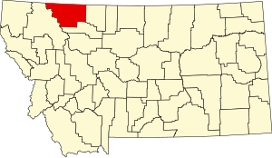
Hill County is a county located in the U.S. state of Montana. As of the 2020 census, the population was 16,309. Its county seat is Havre. It lies along the United States border with Canada, abutting Alberta and Saskatchewan.

<span class="mw-page-title-main">Toole County, Montana</span> County in Montana, United States

Toole County is a county in the northern portion of the U.S. state of Montana. As of the 2020 census, the population was 4,971. Its county seat is Shelby. The county was established in 1914 from parts of Hill County and Teton County and was named after Joseph Toole, the first and fourth governor of Montana. Its northern boundary is the Canada–United States border south of Alberta.

<span class="mw-page-title-main">Pondera County, Montana</span> County in Montana, United States

Pondera County is a county in the U.S. state of Montana. As of the 2020 census, the population was 5,898. Its county seat is Conrad.

<span class="mw-page-title-main">Missoula County, Montana</span> County in Montana, United States

Missoula County is located in the State of Montana. As of the 2020 census, the population was 117,922, making it Montana's third most populous county. Its county seat and most populous city is Missoula. The county was founded in 1860.

<span class="mw-page-title-main">Chouteau County, Montana</span> County in Montana, United States

Chouteau County is a county located in the North-Central region of the U.S. state of Montana. As of the 2020 census, the population was 5,895. Its county seat is Fort Benton. The county was established in 1865 as one of the original nine counties of Montana, and named in 1882 after Pierre Chouteau Jr., a fur trader who established a trading post that became Fort Benton, which was once an important port on the Missouri River.

<span class="mw-page-title-main">Cascade County, Montana</span> County in Montana, United States

Cascade County is a county located in the U.S. state of Montana. As of the 2020 census, the population was 84,414, making it the fifth-most populous county in Montana. Its county seat is Great Falls.

<span class="mw-page-title-main">Browning, Montana</span> Place in Montana, United States

Browning is a former town and current unincorporated community in Glacier County, Montana, United States. It is the headquarters for the Blackfeet Indian Reservation and was the only incorporated town on the Reservation. The population was 1,018 at the 2020 census.

<span class="mw-page-title-main">Cut Bank, Montana</span> City in Montana, United States

Cut Bank is a city in and the county seat of Glacier County, Montana, United States, located just east of the "cut bank" (gorge) along Cut Bank Creek. The population was 3,056 at the 2020 census, The town began in 1891 with the arrival of the Great Northern Railway.

<span class="mw-page-title-main">North Browning, Montana</span> Census-designated place in Montana, United States

North Browning is a census-designated place (CDP) in Glacier County, Montana, United States. The population was 2,408 at the 2010 census.

<span class="mw-page-title-main">South Browning, Montana</span> Census-designated place in Montana, United States

South Browning is a census-designated place (CDP) in Glacier County, Montana, United States. The population was 1,785 at the 2010 census. South Browning is a rural village on the Blackfeet Indian Reservation. It is bordered to the north by the town of Browning.

<span class="mw-page-title-main">Starr School, Montana</span> Census-designated place in Montana, United States

Starr School is a census-designated place (CDP) in Glacier County, Montana, United States. The population was 252 at the 2010 census.

<span class="mw-page-title-main">Blackfeet Nation</span> Indian tribe in Montana, United States

The Blackfeet Nation, officially named the Blackfeet Tribe of the Blackfeet Indian Reservation of Montana, is a federally recognized tribe of Siksikaitsitapi people with an Indian reservation in Montana. Tribal members primarily belong to the Piegan Blackfeet band of the larger Blackfoot Confederacy that spans Canada and the United States.

<span class="mw-page-title-main">Carway, Alberta</span> Hamlet in Alberta, Canada

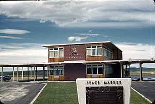
Carway is a hamlet in southern Alberta, Canada within Cardston County. It is a port of entry into the U.S. state of Montana opposite of Port of Piegan. Just on the other side of the border is the Blackfeet Indian Reservation in Glacier County, Montana.

Lewis and Clark National Forest is located in west central Montana, United States. Spanning 2,912 square miles (7,500 km2), the forest is managed as two separate zones. The eastern sections, under the Jefferson Division, is a mixture of grass and shrublands dotted with "island" pockets of forested areas. Here, cattle leases to local ranchers as well as timber harvesting are the norm. The western Rocky Mountain Division, which straddles the Continental divide, is managed chiefly for environmental preservation, as much of the land has been designated as wilderness. Forest headquarters are located in Great Falls, Montana. Local ranger district offices have been established in Choteau, Harlowton, Neihart, Stanford, and White Sulphur Springs.

<span class="mw-page-title-main">St. Mary, Montana</span> Census-Designated Place in Montana, United States

St. Mary is an unincorporated community on the western border of the Blackfeet Indian Reservation adjacent to Glacier National Park in Glacier County, Montana, United States. The village is the eastern terminus of the Going-to-the-Sun Road which bisects the park east to west, a distance of 53 mi (85 km).

Babb is a small unincorporated farming and ranching community in Glacier County, Montana, United States, on the Blackfeet Indian Reservation. The community experiences a large influx of tourists in the summer months as it is the gateway to the Many Glacier area of Glacier National Park. For statistical purposes, the United States Census Bureau has defined Babb as a census-designated place (CDP). It had a population of 174 at the 2010 census.

<span class="mw-page-title-main">Blackfeet Community College</span> Tribal land-grant community college in Browning, Montana, U.S.

Blackfeet Community College is a private tribal land-grant community college on the Blackfeet reservation in Browning, Montana. The Blackfeet reservation occupies an area of 1,525,712 acres adjacent to Glacier National Park, Lewis and Clark National Forest, and the province of Alberta, Canada. In 1994, the college was designated a land-grant college alongside 31 other tribal colleges.

Glacier Country, Montana is a tourism region in the U.S. state of Montana. Glacier Country includes the cities of Missoula, Kalispell, Polson, Libby, Whitefish, Browning, Eureka, and Thompson Falls. Glacier Country is home to Glacier National Park, and Montana's 2nd largest city- Missoula, Montana. The 2015 population of Glacier Country is 332,702.

Big Sky Colony is a Hutterite community and census-designated place (CDP) in Glacier County, Montana, United States. It is in the northeastern part of the county, within the Blackfeet Indian Reservation, 36 miles (58 km) by road northwest of Cut Bank and 32 miles (51 km) northeast of Browning.

References

  1. 1 2 "State & County QuickFacts". United States Census Bureau. Retrieved May 8, 2023.
  2. "Find a County". National Association of Counties. Archived from the original on May 31, 2011. Retrieved June 7, 2011.
  3. History of Cut Bank Cut Bank Chamber of Commerce (accessed January 2, 2019)
  4. Glacier County Historical Museum (accessed January 2, 2019)
  5. "Welcome to Blackfeet Country ~Browning Montana~ Glacier Park". www.blackfeetcountry.com. Retrieved April 2, 2018.
  6. "2010 Census Gazetteer Files". United States Census Bureau. August 22, 2012. Archived from the original on December 5, 2014. Retrieved November 28, 2014.
  7. Leip, David. "Atlas of US Presidential Elections". uselectionatlas.org. Retrieved April 2, 2018.
  8. "Annual Estimates of the Resident Population for Counties: April 1, 2020 to July 1, 2022". United States Census Bureau. Retrieved May 8, 2023.
  9. "U.S. Decennial Census". United States Census Bureau. Retrieved November 28, 2014.
  10. "Historical Census Browser". University of Virginia Library. Retrieved November 28, 2014.
  11. "Population of Counties by Decennial Census: 1900 to 1990". United States Census Bureau. Retrieved November 28, 2014.
  12. "Census 2000 PHC-T-4. Ranking Tables for Counties: 1990 and 2000" (PDF). United States Census Bureau. Archived (PDF) from the original on March 27, 2010. Retrieved November 28, 2014.
  13. Bison, Glacier County MT Google Maps (accessed January 2, 2019)
  14. False Summit, Glacier County MT Google Maps (accessed January 2, 2019)
  15. Fort Piegan, Glacier County MT Google Maps (accessed January 2, 2019)
  16. Gunsight, Glacier County MT Google Maps (accessed January 2, 2019)
  17. Kiowa, Glacier County MT Google Maps (accessed January 2, 2019)
  18. Meriwether, Glacier MT Google Maps (accessed January 2, 2019)
  19. Piegan, Glacier County MT Google Maps (accessed January 2, 2019)
  20. Rising Sun, Glacier County MT Google Maps (accessed January 2, 2019)
  21. Star, Glacier County MT Google Maps (accessed January 2, 2019)
  22. Summit, Glacier County MT Google Maps (accessed January 2, 2019)
  23. Sundance, Glacier County MT Google Maps (accessed January 2, 2019)
  24. Swiftcurrent, Glacier County MT Google Maps (accessed January 2, 2019)
  25. 1 2 "2020 CENSUS - SCHOOL DISTRICT REFERENCE MAP: Glacier County, MT" (PDF). U.S. Census Bureau . Retrieved March 13, 2024. - Text list

48°42′N113°01′W / 48.70°N 113.02°W / 48.70; -113.02