Going-to-the-Sun Road

Last updated

Going-to-the-Sun Road
Going-to-the-Sun Road - Glacier National Park.jpg
The road is often cut into steep rock
USA Montana relief location map.jpg
Red pog.svg
Location in Montana
Usa edcp relief location map.png
Red pog.svg
Going-to-the-Sun Road (the United States)
Location Glacier National Park, Flathead and Glacier counties, Montana, U.S.
Nearest city West Glacier, Montana
Coordinates 48°41′42″N113°49′01″W / 48.695°N 113.817°W / 48.695; -113.817
Built1921–1932; dedicated 1933
ArchitectNational Park Service; Bureau of Public Roads
NRHP reference No. 83001070
Significant dates
Added to NRHPJune 16, 1983 [1]
Designated NHLFebruary 18, 1997 [2]

Going-to-the-Sun Road is a scenic mountain road in the Rocky Mountains of the western United States, in Glacier National Park in Montana. The Sun Road, as it is sometimes abbreviated in National Park Service documents, is the only road that traverses the park, crossing the Continental Divide through Logan Pass at an elevation of 6,646 feet (2,026 m), which is the highest point on the road. [3] Construction began in 1921 and was completed in 1932 with formal dedication in the following summer on July 15, 1933. [4] [5] Prior to the construction of the road, visitors would need to spend several days traveling through the central part of the park, an area which can now be traversed within a few hours, excluding any stops for sightseeing or construction.

Contents

The road is the first to have been registered in all of the following categories: National Historic Place, [6] National Historic Landmark [2] and Historic Civil Engineering Landmark. [7] The road is approximately 50 miles (80 km) long and spans the width of the park between the east and west entrance stations. [3] The National Historic Landmark Nomination records a slightly shorter distance of 48.7 miles which is measured from the first main intersection just outside the park's west entrance to Divide Creek in St. Mary, Montana on the east side of the park. [3]

Name

The road is named after Going-to-the-Sun Mountain which dominates the eastbound view beyond Logan Pass. One Native American legend concerns the deity Sour Spirit who came down from the sun to teach the Blackfeet the basics of hunting. While returning to the sun, an image of Sour Spirit was placed on the mountain as an inspiration for the Blackfeet. Another story has suggested that a late-19th-century Euro-American explorer provided the mountain's name and the legend. [3]

Design

Road map (click map to enlarge) Glac gttsr map with structures.png
Road map (click map to enlarge)

Going-to-the-Sun Road, also known as Glacier Route 1 Road, is notable as one of the first National Park Service projects specifically intended to accommodate the automobile-borne tourist. The road was first conceived by superintendent George Goodwin in 1917, who became the chief engineer of the Park Service the following year. [8] As chief engineer, the new road became Goodwin's primary project, and construction began in 1921.

As the project proceeded, Goodwin lost influence with National Park Service director Stephen Mather, who favored landscape architect Thomas Chalmers Vint's alternative routing of the upper portion of the road along the Garden Wall escarpment. Vint's alignment reduced both switchbacks and the road's visual impact, at increased cost. [9] With Goodwin's resignation, Vint's proposal became the preferred alignment. The entire project was finally opened from end to end in 1933, at a cost of $2.5 million. [10]

The western terminus of the road is at U.S. Route 2 in West Glacier, Montana. The eastern terminus is at U.S. Route 89 in St. Mary.

The two-lane Going-to-the-Sun Road is quite narrow and winding, with hairpin turns, especially west of Logan Pass. Consequently, vehicle lengths over the highest portions of the roadway are limited to no longer than 21 feet (6.4 m) and no wider than 8 feet (2.4 m) between Avalanche Creek and Rising Sun picnic areas which are located many miles below Logan Pass, on the west and east sides of the pass, respectively. Vehicles over 10 feet (3.0 m) in height may not have sufficient clearance due to rock overhangs when driving west between Logan Pass and the hairpin turn called the Loop. [3] The speed limits are 45 mph (72 km/h) in the lower elevations and 25 mph (40 km/h) in the steeper and winding alpine sections. [3]

Repairs

Plowing not yet finished as of June 21 Going-to-the-Sun Road plowed.jpg
Plowing not yet finished as of June 21

The road is one of the most difficult roads in North America to snowplow in the spring. Up to 80 feet (24 m) of snow can lie on top of Logan Pass, and more just east of the pass where the deepest snowfield has long been referred to as the Big Drift. The road takes about ten weeks to plow, even with equipment that can move 4,000 tons of snow in an hour. The snowplow crew can clear as little as 500 feet (150 m) of the road per day. On the east side of the Continental Divide, there are few guardrails due to heavy snows and the resultant late-winter avalanches that have destroyed protective barriers. The road is generally open from early June to mid October, with its latest opening on July 13, 2022, marking the record for the latest opening since the inaugural date of July 15, 1933. [4]

A restoration project by the National Park Service and the Federal Highway Administration has been repairing road damage from many avalanches and rock slides over the years. [11] The repairs, which started in the 1980s and continue to the present day when weather permits, include fixing retaining walls, replacing the original pavement with reinforced concrete, and work on tunnels, bridges, culverts and overlooks. [12]

Buses

Red Jammer bus (2006) Jammer.jpg
Red Jammer bus (2006)

A fleet of vintage 1930s red buses, modernized in 2001 and called Red Jammers, or simply "Reds", continue the tradition of offering guided tours along the road. [13] The original bus drivers became affectionately known as "Gear Jammers" or simply "Jammers" since they had to jam the manual gearbox into low to safely negotiate the steepest road sections. [13] Thirty-three of the original buses were rebuilt with flexible-fuel engines which operate mainly on propane but can use gasoline, and with automatic transmissions, making the Jammer name archaic. [14] [15] Modern-style shuttle buses for shorter trips and Blackfeet tour buses operate on the road as well. [16]

Saint Mary Lake from road By St, Mary Lake on the Going-to-the-Sun Road, 1991.jpg
Saint Mary Lake from road

Going-to-the-Sun Road is shown in the opening credits of the 1980 film The Shining , as aerial flybys of Wild Goose Island and the protagonist's car traveling along the north shore of Saint Mary Lake, through the East Side tunnel and onward, going to a mountain resort hotel for his job interview as a winter caretaker. [17] The road is also featured at night at the climax of the sequel adaptation, Doctor Sleep, when Danny Torrance returns to the Overlook Hotel with Abra to confront the antagonist Rose The Hat.

The road is also seen briefly in the 1994 film Forrest Gump . As Forrest reminisces with Jenny he remembers running across the U.S. and remarks, "Like that mountain lake. It was so clear, Jenny. It looked like there were two skies, one on top of the other." The shots in the background are Going-to-the-Sun Road and Saint Mary Lake. [18]

The road is the subject of the song "Going-to-the-Sun Road" by Fleet Foxes, featured on their 2020 album Shore.

See also

Clements Mountain and the East Side tunnel Going-to-the-Sun Road-27527-2.jpg
Clements Mountain and the East Side tunnel

Major points of interest along the road from west-to-east include:

Related Research Articles

<span class="mw-page-title-main">Great Smoky Mountains National Park</span> National park in Tennessee and North Carolina

Great Smoky Mountains National Park is an American national park in the southeastern United States, with parts in North Carolina and Tennessee. The park straddles the ridgeline of the Great Smoky Mountains, part of the Blue Ridge Mountains, which are a division of the larger Appalachian Mountain chain. The park contains some of the highest mountains in eastern North America, including Clingmans Dome, Mount Guyot, and Mount Le Conte. The border between the two states runs northeast to southwest through the center of the park. The Appalachian Trail passes through the center of the park on its route from Georgia to Maine. With 13 million visitors in 2023, the Great Smoky Mountains National Park is the most visited national park in the United States.

<span class="mw-page-title-main">Allegheny Portage Railroad</span> National Historic Site of the United States

The Allegheny Portage Railroad was the first railroad constructed through the Allegheny Mountains in central Pennsylvania. It operated from 1834 to 1854 as the first transportation infrastructure through the gaps of the Allegheny that connected the midwest to the eastern seaboard across the barrier range of the Allegheny Front. Approximately 36 miles (58 km) long overall, both ends connected to the Pennsylvania Canal, and the system was primarily used as a portage railway, hauling river boats and barges over the divide between the Ohio and the Susquehanna Rivers. Today, the remains of the railroad are preserved within the Allegheny Portage Railroad National Historic Site operated by the National Park Service.

<span class="mw-page-title-main">Hana Highway</span> Highway in Hawaii, USA

The Hana Highway is a 64.4-mile-long (103.6 km) stretch of Hawaii Routes 36 and 360 which connects Kahului to the town of Hana in east Maui. To the east of Kalepa Bridge, the highway continues to Kipahulu as Hawaii Route 31. Although Hana is only about 52 miles (84 km) from Kahului, an uninterrupted car-trip takes about 2.5 hours to drive, since the highway is very winding, narrow, and passes over 59 bridges, of which 46 are only one lane wide. There are approximately 620 curves along Route 360 from just east of Kahului to Hana, almost all of it through lush, tropical rainforest. Many of the concrete and steel bridges date back to 1910 and all but one are still in use. That one bridge, badly damaged by erosion, has been replaced by a portable steel ACROW or Bailey bridge erected by the United States Army Corps of Engineers.

<span class="mw-page-title-main">Colonial Parkway</span> Scenic parkway in Virginia

Colonial Parkway is a 23-mile (37 km) scenic parkway linking the three points of Virginia's Historic Triangle, Jamestown, Williamsburg, and Yorktown. It is part of the National Park Service's Colonial National Historical Park. Virginia's official state classification for the parkway is State Route 90003. With portions built between 1930 and 1957, it links the three communities via a roadway shielded from views of commercial development. The roadway is toll-free, is free of semi trucks, and has speed limits of around 35 to 45 mph. As a National Scenic Byway and All-American Road, it is also popular with tourists due to the James River and York River ends of the parkway.

<span class="mw-page-title-main">Ohio and Erie Canal</span> 19th-century manmade water route between Akron and Cleveland, Ohio, USA

The Ohio and Erie Canal was a canal constructed during the 1820s and early 1830s in Ohio. It connected Akron with the Cuyahoga River near its outlet on Lake Erie in Cleveland, and a few years later, with the Ohio River near Portsmouth. It also had connections to other canal systems in Pennsylvania.

<span class="mw-page-title-main">Vicksburg National Military Park</span> American Civil War historic site

Vicksburg National Military Park preserves the site of the American Civil War Battle of Vicksburg, waged from March 29 to July 4, 1863. The park, located in Vicksburg, Mississippi, also commemorates the greater Vicksburg Campaign which led up to the battle. Reconstructed forts and trenches evoke memories of the 47-day siege that ended in the surrender of the city. Victory here and at Port Hudson, farther south in Louisiana, gave the Union control of the Mississippi River.

<span class="mw-page-title-main">Chickamauga and Chattanooga National Military Park</span> Preserved battlefields of the American Civil War in Georgia and Tennessee, United States

Chickamauga and Chattanooga National Military Park, located in northern Georgia and southeastern Tennessee, preserves the sites of two major battles of the American Civil War: the Battle of Chickamauga and the Siege of Chattanooga. A detailed history of the park's development was provided by the National Park Service in 1998.

<span class="mw-page-title-main">Prince William Forest Park</span> Protected forest in Virginia, U.S.

Prince William Forest Park is a national park in the U.S. state of Virginia within Prince William County, located adjacent to the Marine Corps Base Quantico near the town of Dumfries. Established as Chopawamsic Recreational Demonstration Area in 1936, the park is the largest protected natural area in the Washington, D.C. metropolitan region at over 13,000 acres (5,300 ha).

<span class="mw-page-title-main">Yukon–Charley Rivers National Preserve</span> United States national preserve in Alaska

Yukon–Charley Rivers National Preserve is a United States national preserve located in east central Alaska along the border with Canada. Managed by the National Park Service, the preserve encompasses 130 miles (208 km) of the 1,800-mile (3,000 km) Yukon River and the entire Charley River basin. The preserve protects the undeveloped Charley River and a significant portion of the upper Yukon. The interior Alaskan region experiences extremes of weather, with temperatures that can vary from −50 °F (−46 °C) in winter to 97 °F (36 °C) in summertime. The Yukon provided a means of access to the region, which is entirely roadless, during the late 19th century and early 20th centuries. Gold rushes in Alaska brought prospectors, who operated gold dredges to recover significant quantities of placer gold from area creeks. Today the preserve includes part of the route of the annual Yukon Quest dogsled race, which runs every February. During the summer float trips are popular on the Yukon and Charley Rivers.

<span class="mw-page-title-main">Croton Aqueduct</span> Pipeline that carried water to New York City from its reservoirs in 19th century

The Croton Aqueduct or Old Croton Aqueduct was a large and complex water distribution system constructed for New York City between 1837 and 1842. The great aqueducts, which were among the first in the United States, carried water by gravity 41 miles (66 km) from the Croton River in Westchester County to reservoirs in Manhattan. It was built because local water resources had become polluted and inadequate for the growing population of the city. Although the aqueduct was largely superseded by the New Croton Aqueduct, which was built in 1890, the Old Croton Aqueduct remained in service until 1955.

The Birmingham District is a geological area in the vicinity of Birmingham, Alabama, where the raw materials for making steel - limestone, iron ore, and coal - are found together in abundance. The district includes Red Mountain, Jones Valley, and the Warrior and Cahaba coal fields in Central Alabama.

<span class="mw-page-title-main">Hungry Horse Dam</span> Dam in Montana

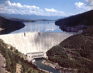
Hungry Horse Dam is an arch dam in the Western United States, on the South Fork Flathead River in the Rocky Mountains of northwest Montana. It is located in Flathead National Forest in Flathead County, about fifteen miles (24 km) south of the west entrance to Glacier National Park, nine miles (14 km) southeast of Columbia Falls, and twenty miles (32 km) northeast of Kalispell. The Hungry Horse project, dam, and powerplant are operated by the U.S. Bureau of Reclamation. The entrance road leading to the dam is located in Hungry Horse.

<span class="mw-page-title-main">Acadia National Park carriage paths, bridges and gatehouses</span> United States historic place

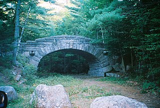
Acadia National Park, largely on Mount Desert Island, off the coast of the U.S. state of Maine, was created in part by land and other donations by John D. Rockefeller Jr. Between 1919 and 1931, Rockefeller, who was opposed to the introduction of automobiles on the island, personally oversaw the construction of a network of carriage roads, closed to motorized vehicles, on the eastern half of the island, including sixteen granite bridges and two gatehouses. The major portion of this network now falls within the bounds of the national park, and was listed on the National Register of Historic Places in 1979.

<span class="mw-page-title-main">Grand Loop Road</span> United States historic place

The Grand Loop Road is a historic district which encompasses the primary road system in Yellowstone National Park. Much of the 140-mile (230 km) system was originally planned by Captain Hiram M. Chittenden of the US Army Corps of Engineers in the early days of the park, when it was under military administration. The Grand Loop Road provides access to the major features of the park, including the Upper, Midway and Lower geyser basins, Mammoth Hot Springs, Tower Fall, the Grand Canyon of the Yellowstone and Yellowstone Lake.

<span class="mw-page-title-main">Generals' Highway Stone Bridges</span> United States historic place

The Generals' Highway Stone Bridges, built in 1930, are part of the Generals' Highway from the General Grant Grove of giant sequoias in Kings Canyon National Park through Sequoia National Park. One bridge spans the Marble Fork of the Kaweah River in a wooded setting, while the other, similar bridge spans Clover Creek in a bare canyon.

<span class="mw-page-title-main">Zion – Mount Carmel Highway</span> United States historic place

The Zion – Mount Carmel Highway is a 25-mile (40 km) long road in Washington and Kane counties in southern Utah, United States, that is listed on the National Register of Historic Places and is a National Historic Civil Engineering Landmark.

<span class="mw-page-title-main">Baltimore and Ohio and Related Industries Historic District</span> Historic district in West Virginia, United States

The Baltimore and Ohio Related Industries Historic District comprises a portion of Martinsburg, West Virginia to either side of the Baltimore and Ohio Railroad line as it runs through the city. The district includes the Baltimore and Ohio Railroad Martinsburg Shops, a National Historic Landmark, and a variety of industrial and commercial concerns that depended on the railroad.

<span class="mw-page-title-main">St. Andrews Creek Bridge</span> United States historic place

The St. Andrews Creek Bridge was built in 1930-31 as part of the West Side Road in Mount Rainier National Park. The bridge spans 26 feet (7.9 m) and is almost 34 feet (10 m) wide, carrying a two-lane road on a stone-faced concrete bridge. The West Side Road was planned to link the Nisqually and Carbon River entrances to the park, but only 13 miles (21 km) were completed in six years.

<span class="mw-page-title-main">Yosemite Valley Bridges</span> United States historic place

The Yosemite Valley Bridges are eight bridges in the Yosemite Valley of Yosemite National Park, most of them spanning the Merced River. Five of them were built in 1928, with the remainder built between 1921 and 1933. The bridges feature a concrete structure faced with local stone, in an elliptical or three-centred arch configuration. They are notable for their uniform character and for their conformance to tenets of the National Park Service rustic style. Design work for the seven newer bridges was by George D. Whittle of the San Francisco District Office of the U.S. Bureau of Public Roads for the National Park Service. Concrete bridges were chosen at the urging of Thomas Chalmers Vint of the Park Service, in lieu of alternative designs for steel truss bridges, or suspension bridges suggested by the park superintendent.

<span class="mw-page-title-main">Transcontinental Railroad Grade</span> United States historic place

The Transcontinental Railroad Grade is a section of railway in northwest Utah, near Corinne, Utah, which was listed on the National Register of Historic Places in 1994.

References

  1. "National Register Information System". National Register of Historic Places . National Park Service. January 23, 2007.
  2. 1 2 "Going-to-the-Sun Road". National Historic Landmark summary listing. National Park Service. Archived from the original on January 9, 2016. Retrieved January 9, 2016.
  3. 1 2 3 4 5 6 "Going-to-the-Sun Road FAQs". National Park Service. October 19, 2009. Archived from the original on May 28, 2010. Retrieved May 11, 2010.
  4. 1 2 Scott, Tristan (April 7, 2011). "Glacier's Going-to-the-Sun Road to open July 13, 2nd latest ever". Missoulian. Archived from the original on April 26, 2012. Retrieved January 9, 2016.
  5. "Session due on Sun Road improvement". Spokesman-Review. July 18, 1967. p. 6.
  6. "National Register of Historic Places Inventory - Nomination Form". National Park Service. June 16, 1983. Archived from the original on January 9, 2016. Retrieved January 9, 2016.
  7. "Top 10 Things...#2". National Park Service. January 9, 2016. Retrieved January 9, 2016.
  8. Carr, p. 160.
  9. Carr, p. 171.
  10. Carr, p. 186.
  11. "Going-to-the-Sun Road Project". Federal Highway Administration. October 16, 2015. Archived from the original on October 27, 2015. Retrieved January 9, 2016.
  12. "Top 10 Things...#3-7". National Park Service. January 9, 2016. Retrieved January 9, 2016.
  13. 1 2 "On the Road Again: Glacier National Park's Red Buses" (PDF). National Park Service. Archived from the original (PDF) on February 17, 2013. Retrieved October 4, 2016.
  14. Wille, Chris (May 5, 2002). "Classic jammers slowly returning to Glacier". Spokesman-Review. Spokane, Washington. p. H4.
  15. Siano, Joseph (September 1, 2002). "Parks take steps to clean air". Sunday Star-News. Wilmington, North Carolina. New York Times News Service. p. 9D.
  16. "Plan Your Visit-Getting Around". National Park Service. January 9, 2016. Retrieved January 9, 2016.
  17. "The Shining (1980) - IMDb".
  18. "Montanakids | Forrest Gump".

Carr, Ethan (1998). Wilderness by Design: Landscape Architecture & the National Park Service . University of Nebraska Press. ISBN   0-8032-6383-X.

Further reading