Waterton Lakes National Park

Last updated
Waterton Lakes National Park
Watertonlake.jpg
Upper Waterton Lake
Canada relief map 2.svg
Red pog.svg
Location of Waterton Lakes in Canada
Canada Alberta relief location map - transverse mercator proj.svg
Red pog.svg
Location of Waterton Lakes in Alberta
Location Alberta, Canada
Nearest city Pincher Creek
Coordinates 49°02′45″N113°54′55″W / 49.04583°N 113.91528°W / 49.04583; -113.91528
Area505 km2 (195 sq mi)
Established1895 (national park)
1979 (biosphere reserve)
1995 (world heritage site)
Visitors475,842(in 2022–23 [1] )
Governing bodyI.D. Council, Parks Canada
Part of Waterton-Glacier International Peace Park
Criteria Natural: vii, ix
Reference 354
Inscription1995 (19th Session)

Waterton Lakes National Park is in the southwest corner of Alberta, Canada. The national park borders Glacier National Park in Montana, United States. Waterton was the fourth Canadian national park, formed in 1895 as Kootenay Lakes Forest Reserve. It is named after Waterton Lake, in turn after the Victorian naturalist and conservationist Charles Waterton. Its range is between the Rocky Mountains and prairies. This park contains 505 km2 (195 sq mi) of rugged mountains and wilderness. It has a diverse ecosystem.

Contents

Operated by Parks Canada, Waterton is open all year, but the main tourist season is during July and August. The only commercial facilities available within the park are located at the Waterton Park townsite. This park ranges in elevation from 1,290 metres (4,232 ft) at the townsite to 2,910 m (9,547 ft) at Mount Blakiston. It offers many scenic trails, including Crypt Lake trail. In 2012/2013, Waterton Lakes National Park had 402,542 visitors. [2]

The park is the subject of a short film in 2011's National Parks Project , directed by Peter Lynch and scored by Cadence Weapon, Laura Barrett and Mark Hamilton. [3]

History

William Pearce, a Dominion Land Surveyor was the first to suggest a park be established in the vicinity of Waterton Lakes in his 1886 annual report, although no action was taken by the government. In 1893, Frederick William Godsal, a rancher who resided north of the lakes wrote Pearce referencing his 1886 report and suggested the area be turned into a park reserve, Pearce forwarded the proposal, noting the land had no value for agricultural and minimal grazing potential. Minister of the Interior Thomas Mayne Daly came across the proposal and directed a park reserve be created in the area. Finally on May 30, 1895, Order-in-Council 1895-1621 established a 140 km2 (54 sq mi) unnamed forest park under the Dominion Lands Act . [4] [5]

While oil had been found in the area since the late 1880s, the government began approving reservation and sales of land for prospecting in 1898. In 1901, John Lineham of Okotoks organized the Rocky Mountain Drilling Company. In 1902 he drilled the first oil exploration well in Alberta on the site of oil seeps near Cameron Creek. Despite a small recovery of 34° API sweet oil, neither this well nor seven later exploration attempts resulted in production. [6] The oil well and surrounding area was designated a National Historic Site of Canada in 1965. [7] By 1905 more than half of the sections of land compromising the park had been sold or reserved for oil exploration. On September 21, 1905, Frederick William Godsal wrote the Secretary of the Interior requesting he consider expanding the park reserve for scenic and recreational purposes. The Dominion Forest Reserves Act which came into force in 1906 established the Kootenay Lakes Forest Reserve under the authority of the Superintendent of Forestry. [8]

In 1911 Minister of the Interior Frank Oliver introduced the Dominion Forest Reserves and Parks Act which designated all existing mountain parks, Elk Island and Buffalo Parks into forest reserves, with the authority to designate all or part of the reserve a "Dominion Park" (later National Park). On June 8, 1911, Order-in-Council P.C. 1338 designated 35 km2 (14 sq mi) of the area of Waterton Lakes Forest Reserve as Dominion Park, much smaller than expected by resident staff, and only a small portion of the original 1895 reserve of 140 km2 (54 sq mi). [9] In 1914, Frank Oliver's successor as Minister of the Interior, William James Roche, significantly expanded the area of Waterton Lakes Park to 1,096 km2 (423 sq mi). [10] [8] [11]

In 1920 William Thomson, the designer and head professional of the original golf course in Banff National Park was brought to Waterton to design a nine-hole golf course. A clubhouse would be constructed in 1928 and the course was expanded to 18 holes between 1931 and 1936. Further renovations to the course in the 1950s were designed by golf course architect Stanley Thompson. [12]

Prince of Wales Hotel

The Prince of Wales Hotel, one of Canada's grand railway hotels, was constructed between 1926 and 1927 adjacent to Upper Waterton Lakes, by the Great Northern Railway of the United States in an attempt to lure American tourists during the U.S. prohibition era. The hotel which opened in July 1927 is the only grand railway hotel in Canada to be constructed by an American railway company. The hotel was named after the Prince of Wales (later King Edward VIII), in a transparent attempt to entice him to stay in the hotel on his 1927 Canadian tour, but the prince stayed at his own nearby ranch in Pekisko, Alberta, instead. [13] The hotel was designated as a national historic site of Canada on 6 November 1992. [14]

Later history

In 1932, Waterton-Glacier International Peace Park was formed from Waterton Lakes National Park and Glacier. It was dedicated to world peace by Sir Charles Arthur Mander on behalf of Rotary International on 18 June 1932, whose members from the Alberta and Montana chapters lobbied for the formation of the park. The Peace Park was the first of its nature in the world, and was intended to promote goodwill between nations and underscore the international nature of protection of wilderness. [15]

In terms of local governance, those lands within Waterton Lakes National Park were split between the Municipal District of Kerr No. 39 and the Municipal District of Castle River No. 40 prior to 1944. [16] Following a partial amalgamation of the two municipal districts, remnant unsurveyed lands within the park were incorporated as Improvement District (ID) No. 11 on January 1, 1944. [16] It was renumbered to ID No. 8 on April 1, 1945, and again to ID No. 4 on January 1, 1969. [16]

The Waterton-Glacier International was inscribed a UNESCO World Heritage Site in 1995. [17] In 1979, Waterton became Canada's second biosphere reserve and the first Canadian national park to take part in this UNESCO program. Biosphere Reserves are created to achieve a better understanding of the relationship between humans and the natural environment. [18]

In September 2017, a large forest fire forced the evacuation of the townsite and park. The fire burned through 200 km2 of the park, destroying the visitor centre, stables and other buildings. Some 80% of hiking trails were affected and several remained closed for the 2018 season. [19]

Geology

The oldest rocks in the park are marine sediments dating back 1.5 billion years. These rocks are composed of limestone, dolomite and igneous rocks. There are fossilized sea beds as well as salt pseudomorph. [20] There are numerous stromatolite formations that are 1.3 billion years old. [21]

Unlike the Canadian Rockies, whose sedimentary strata are more or less inclined, the Waterton sediments are characterized by a single overlap. The Lewis Overthrust allowed sediment Proterozoic to move as a unit, more or less, horizontally on the rocks of the Cretaceous period dating from about 70 million years ago on a remote 100 km south-east of the mountain's present location. [20] The fact that older rocks end up on younger rocks is a rare occurrence in geology. Under the Proterozoic layer, there is a layer dating from the Upper Cretaceous which is mainly composed of schist. [20]

Although there are no glaciers left in Waterton, aside from a few expanses of eternal snow, the landscape has been greatly shaped by the Wisconsin glaciation. The park has many glacial troughs, the hanging valleys, the ridge, the cirque, the kame and esker. Since the end of the last ice age, the Cameron and Blakiston rivers have formed two alluvial fans at their mouths. [20]

Ecology

Waterton Lakes National Park spans four ecoregions, foothills parkland, montane, subalpine and alpine. Waterton is the only National Park in Canada with the foothills parkland ecoregion, which comprises approximately 10 percent of the Park and occupies a narrow band along the eastern edge of the foothills of Alberta from Calgary to Waterton and into parts of the United States. [22]

Flora

There are over 1000 species of vascular plants found in the park. Over 20 species are endemic to the park such as Lewis' mock-orange and white-veined wintergreen. Over 50 species of plants that are found the park are rare in Canada such as Bolander's quillwort, Lyall's scorpionweed, and Brewer's monkeyflower. [23] Waterton Lakes National Park is also home to small ferns called moonworts and the Waterton moonwort is endemic to the park. [24]

Fauna

Animals that inhabit this national park include wolverines, bighorn sheep, bald eagles, white-tailed deer, mule deer, mountain goats, elk, moose, foxes, timber wolves, bison, coyotes, beavers, river otters, cougars, lynxes, bobcats, snowshoe hares, pikas, hoary marmots, grizzly bears and black bears. Many bird species nest or migrate through the park, some of which include bald eagles, Canada geese, orange-crowned warblers, and MacGillivray's warblers. [25]

Climate

Waterton Lakes National Park Cameron Falls weather station has a humid continental climate (Koppen: Dfb), bordering relatively closely on a subarctic climate (Dfc). Summertime is mild with cool nights, while winter is chilly with highs around freezing. Snowfall is heavy, averaging 481.5 cm (189.6 inches). [26]

Climate data for Waterton Lakes National Park Cameron Falls Weather Station, Alberta, Canada, 19712000 normals, extremes 19751995
MonthJanFebMarAprMayJunJulAugSepOctNovDecYear
Record high °C (°F)15.0
(59.0)
16.5
(61.7)
18.0
(64.4)
27.0
(80.6)
31.0
(87.8)
31.0
(87.8)
36.0
(96.8)
35.0
(95.0)
32.5
(90.5)
29.0
(84.2)
18.5
(65.3)
15.0
(59.0)
36.0
(96.8)
Mean daily maximum °C (°F)−0.6
(30.9)
0.9
(33.6)
5.2
(41.4)
9.5
(49.1)
14.6
(58.3)
19.0
(66.2)
22.7
(72.9)
22.0
(71.6)
17.2
(63.0)
11.1
(52.0)
2.7
(36.9)
−0.7
(30.7)
10.3
(50.5)
Daily mean °C (°F)−5.2
(22.6)
−4.0
(24.8)
0.2
(32.4)
4.2
(39.6)
8.9
(48.0)
12.8
(55.0)
16.0
(60.8)
15.4
(59.7)
11.0
(51.8)
6.2
(43.2)
−1.2
(29.8)
−4.7
(23.5)
5.0
(41.0)
Mean daily minimum °C (°F)−9.7
(14.5)
−8.9
(16.0)
−4.9
(23.2)
−1.1
(30.0)
3.1
(37.6)
6.5
(43.7)
9.3
(48.7)
8.8
(47.8)
4.9
(40.8)
1.2
(34.2)
−5.0
(23.0)
−8.8
(16.2)
−0.4
(31.3)
Record low °C (°F)−38.0
(−36.4)
−37.0
(−34.6)
−30.6
(−23.1)
−22.8
(−9.0)
−7.0
(19.4)
−1.0
(30.2)
0.5
(32.9)
−4.0
(24.8)
−8.0
(17.6)
−23.0
(−9.4)
−33.0
(−27.4)
−37.0
(−34.6)
−38.0
(−36.4)
Average precipitation mm (inches)82.2
(3.24)
74.6
(2.94)
89.7
(3.53)
89.9
(3.54)
121.3
(4.78)
109.8
(4.32)
80.0
(3.15)
75.2
(2.96)
73.2
(2.88)
101.5
(4.00)
115.7
(4.56)
90.2
(3.55)
1,103.2
(43.43)
Average rainfall mm (inches)17.7
(0.70)
14.6
(0.57)
16.4
(0.65)
39.2
(1.54)
107.1
(4.22)
109.8
(4.32)
80.0
(3.15)
72.6
(2.86)
67.1
(2.64)
60.3
(2.37)
45.2
(1.78)
18.5
(0.73)
648.4
(25.53)
Average snowfall cm (inches)67.1
(26.4)
65.9
(25.9)
80.5
(31.7)
49.7
(19.6)
13.3
(5.2)
0.0
(0.0)
0.0
(0.0)
2.5
(1.0)
5.6
(2.2)
43.4
(17.1)
74.8
(29.4)
78.8
(31.0)
481.5
(189.6)
Average precipitation days (≥ 0.2 mm)12.911.713.111.915.615.512.013.411.912.114.313.0157.3
Average rainy days (≥ 0.2 mm)2.42.32.76.414.915.512.013.211.48.85.72.697.8
Average snowy days (≥ 0.2 mm)10.79.810.56.51.70.00.00.141.04.010.110.965.2
Source: Environment Canada [26]

Biosphere Reserve

In 1979, Waterton and bordering Glacier National park in the US were designated as World Biosphere reserves, preserving mountains, prairie, lakes and freshwater wetlands ecosystems. Habitats represented in the parks' range include: prairie grasslands, aspen grove forests, alpine tundra/high meadows, lower subalpine forests, deciduous and coniferous forests. [27]

World Heritage Site

The park is part of the Waterton-Glacier International Peace Park, designated as World Heritage Site in 1995 for their distinctive climate, physiographic setting, mountain-prairie interface, and tri-ocean hydrographical divide. They are areas of significant scenic values with abundant and diverse flora and fauna. [28]

See also

Related Research Articles

<span class="mw-page-title-main">Rocky Mountains</span> Major mountain range in western North America

The Rocky Mountains, also known as the Rockies, are a major mountain range and the largest mountain system in North America. The Rocky Mountains stretch 3,000 miles in straight-line distance from the northernmost part of western Canada, to New Mexico in the southwestern United States. Depending on differing definitions between Canada and the U.S., its northern terminus is located either in northern British Columbia's Terminal Range south of the Liard River and east of the Trench, or in the northeastern foothills of the Brooks Range/British Mountains that face the Beaufort Sea coasts between the Canning River and the Firth River across the Alaska-Yukon border. Its southernmost point is near the Albuquerque area adjacent to the Rio Grande rift and north of the Sandia–Manzano Mountain Range. Being the easternmost portion of the North American Cordillera, the Rockies are distinct from the tectonically younger Cascade Range and Sierra Nevada, which both lie farther to its west.

<span class="mw-page-title-main">Banff National Park</span> National park in Alberta, Canada

Banff National Park is Canada's oldest national park, established in 1885 as Rocky Mountains Park. Located in Alberta's Rocky Mountains, 110–180 kilometres (68–112 mi) west of Calgary, Banff encompasses 6,641 square kilometres (2,564 sq mi) of mountainous terrain, with many glaciers and ice fields, dense coniferous forest, and alpine landscapes. Provincial forests and Yoho National Park are neighbours to the west, while Kootenay National Park is located to the south and Kananaskis Country to the southeast. The main commercial centre of the park is the town of Banff, in the Bow River valley.

<span class="mw-page-title-main">Glacier National Park (U.S.)</span> Park in Montana on the Canadian border

Glacier National Park is an American national park located in northwestern Montana, on the Canada–United States border, adjacent to Waterton Lakes National Park in Canada—the two parks are known as the Waterton-Glacier International Peace Park. The park encompasses more than 1 million acres (4,000 km2) and includes parts of two mountain ranges, more than 130 named lakes, more than 1,000 different species of plants, and hundreds of species of animals. This vast pristine ecosystem is the centerpiece of what has been referred to as the "Crown of the Continent Ecosystem," a region of protected land encompassing 16,000 sq mi (41,000 km2).

<span class="mw-page-title-main">Canadian Rockies</span> Mountain range in Canada

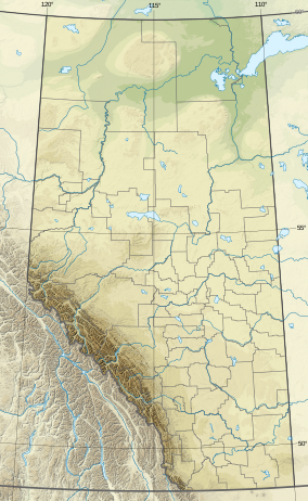
The Canadian Rockies or Canadian Rocky Mountains, comprising both the Alberta Rockies and the British Columbian Rockies, is the Canadian segment of the North American Rocky Mountains. It is the easternmost part of the Canadian Cordillera, which is the northern segment of the North American Cordillera, the expansive system of interconnected mountain ranges between the Interior Plains and the Pacific Coast that runs northwest–southeast from central Alaska to the Isthmus of Tehuantepec in Mexico.

<span class="mw-page-title-main">Waterton-Glacier International Peace Park</span> International park

The Waterton-Glacier International Peace Park is the union of Waterton Lakes National Park in Canada and Glacier National Park in the United States. Both parks are declared Biosphere Reserves by UNESCO and their union as a World Heritage Site.

<span class="mw-page-title-main">Riding Mountain National Park</span> National park in Manitoba, Canada

Riding Mountain National Park is a national park in Manitoba, Canada. The park is located within Treaty 2 Territory and sits atop the Manitoba Escarpment. Consisting of a protected area 2,969 km2 (1,146 sq mi), the forested parkland stands in sharp contrast to the surrounding prairie farmland. It was designated a national park because it protects three different ecosystems that converge in the area; grasslands, upland boreal and eastern deciduous forests. It is most easily reached by Highway 10 which passes through the park. The south entrance is at the townsite of Wasagaming, which is the only commercial centre within the park boundaries.

<span class="mw-page-title-main">Protected areas of Canada</span> Areas protected for conservation or historical reasons

Protected areas of Canada consist of approximately 12.1 percent of the nation's landmass and freshwater are considered conservation areas, including 11.4 percent designated as protected areas. Approximately 13.8 percent of Canada's territorial waters are conserved, including 8.9 percent designated as protected areas. Terrestrial areas conserved have increased by 65 percent in the 21st century, while marine areas conserved have increased by more than 3,800 percent.

<span class="mw-page-title-main">Prince of Wales Hotel</span> Building in Waterton, Alberta

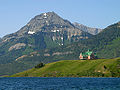
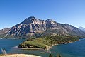
The Prince of Wales Hotel is a historic hotel located in Waterton, Alberta, Canada. It is situated within Waterton Lakes National Park, overlooking Upper Waterton Lakes. It was designed by and built for the Great Northern Railway company. It is currently managed by the Pursuit Collection.

Height of the Rockies Provincial Park is a provincial park in the Canadian Rockies of south eastern British Columbia, Canada. It is located west of the Continental Divide, adjacent to Elk Lakes Provincial Park.

<span class="mw-page-title-main">Lewis Range</span> Mountain range in Montana, United States and Alberta, Canada

The Lewis Range is a mountain range located in the Rocky Mountains of northern Montana, United States and extreme southern Alberta, Canada. It was formed as a result of the Lewis Overthrust, a geologic thrust fault resulted in the overlying of younger Cretaceous rocks by older Proterozoic rocks. The range is located within Waterton Lakes National Park in Alberta, Canada and Glacier National Park and the Bob Marshall Wilderness Complex in Montana, United States. The highest peak is Mount Cleveland at 10,479 ft (3,194 m).

<span class="mw-page-title-main">Tourism in Alberta</span> Tourism in Alberta, Canada

Alberta has been a tourist destination since the early days of the 20th Century, with attractions including national parks, National Historic Sites of Canada, urban arts and cultural facilities, outdoor locales for skiing, hiking and camping, shopping locales such as West Edmonton Mall, outdoor festivals, professional athletic events, international sporting competitions such as the Commonwealth Games and Olympic Winter Games, as well as more eclectic attractions.

<span class="mw-page-title-main">Waterton Lake</span> Lake in the American state of Montana and in the Canadian province of Alberta

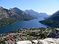
Waterton Lake is a mountain lake in southern Alberta, Canada, and northern Montana, United States. The lake is composed of two bodies of water, connected by a shallow channel known locally as the Bosporus. The two parts are referred to as Middle Waterton Lake, and Upper Waterton Lake, the latter of which is divided by the Canada–United States border with Canada containing about two thirds of the lake while the southern third falls in the United States. The Boundary Commission Trail ends at the lake as the last border marker was placed there on 8 August 1874. The United States Geological Survey gives the geocoordinates of 49°03′00″N113°54′03″W for Upper Waterton Lake. Lower Waterton Lake is north of Middle Waterton Lake and is separated by a channel known as the Dardanelles.

Babb is a small unincorporated farming and ranching community in Glacier County, Montana, United States, on the Blackfeet Indian Reservation. The community experiences a large influx of tourists in the summer months as it is the gateway to the Many Glacier area of Glacier National Park. For statistical purposes, the United States Census Bureau has defined Babb as a census-designated place (CDP). It had a population of 174 at the 2010 census.

<span class="mw-page-title-main">Montane Cordillera</span> Ecozone in south-central British Columbia

The Montane Cordillera Ecozone, as defined by the Commission for Environmental Cooperation (CEC), is an ecozone in south-central British Columbia and southwestern Alberta, Canada. A rugged and mountainous ecozone spanning 473,000 square kilometres, it still contains "two of the few significant agricultural areas of the province", the Creston Valley and the Okanagan Valley. Primarily a mountainous region, it consists of rugged ecosystems such as alpine tundra, dry sagebrush and dense conifer forests. The interior plains are encircled by a ring of mountains. The area has a mild climate throughout the year, with typically dry summers and wet winters.

<span class="mw-page-title-main">First Oil Well in Western Canada</span> Defunct oil well and national historic site of Canada

The First Oil Well in Western Canada, also known as Lineham Discovery Well No. 1, is a defunct oil well and national historic site of Canada. Which commemorates the September 21, 1902 oil strike in what is now Waterton Lakes National Park, Alberta. The oil well originally drilled in 1902, was the first productive oil well in the Western Canadian provinces.

<span class="mw-page-title-main">Waterton Biosphere Reserve</span> UNESCO Biosphere Reserve in Alberta, Canada

Waterton Biosphere Reserve is a UNESCO Biosphere Reserve encompassing Waterton Lakes National Park in the extreme south-west of the Province of Alberta, Canada. The reserve includes a section of the east slopes of the Rocky Mountains extending from the Continental Divide to the edge of the Canadian Great Plains to the east. The Glacier Biosphere Reserve and National Park in Montana, USA is located to the south of the area. The reserve is administered by Waterton Lakes National Park and the Waterton Biosphere Association.

Castle Wildland Provincial Park is a wildland provincial park in southern Alberta, Canada. The designation of the park was established on 20 January 2017, with an effective date of 16 February 2017. The designation involved the protection of 79,678 hectares of land. The park is included in the South Saskatchewan Region Land Use Framework. The park, along with Castle Provincial Park, is managed under the Castle Management Plan. The park takes its name from the region including the Castle River and Castle Peak of Windsor Mountain. Despite the name, it is not associated with Castle Mountain which is in Banff National Park.

References

  1. Canada, Parks. "Parks Canada attendance 2022_23 - Parks Canada attendance 2022_23 - Open Government Portal". open.canada.ca. Retrieved 2024-05-07.
  2. "Parks Canada Attendance 2007-08 to 2012-13" (PDF). Parks Canada. July 31, 2013. p. 2. Retrieved May 29, 2014.
  3. "The Monday Q&A: Film director Peter Lynch" . Retrieved 28 April 2020.
  4. Lothian, W.F. (1977). "Chapter 1 The Early Years (Up to 1900)". A History of Canada's National Parks. Vol. II. Parks Canada. Retrieved 25 March 2020.
  5. "1895-1621 - Dominion lands - Min. [Minister of the] Interior 1895/05/27 recds. [recommends] reservation certain for a Forest Park". Library and Archives Canada. Privy Council Office. May 30, 1895. Retrieved 25 March 2020.
  6. Smith, Thomas (2010). "Western Canada's First Oil Discovery". GEO ExPro. 7 (4). Retrieved 5 August 2020.
  7. First Oil Well in Western Canada National Historic Site . Canadian Register of Historic Places . Retrieved 5 August 2020.
  8. 1 2 Lothian, W.F. (1977). "Chapter 2 Expansion in the West (1900 to 1972)". A History of Canada's National Parks. Vol. II. Parks Canada. Retrieved 25 March 2020.
  9. "1911-1338 - Dominion Parks established Glacier Park, Yoho Park, Rocky Mountains Park, Jasper Park, Waterton Lake Park - Min. Int. [Minister of the Interior] 1911/06/01". Library and Archives Canada. Privy Council Office. June 6, 1911. Retrieved 25 March 2020.
  10. Lothian, W.F. (1977). "Chapter 4 National Parks Administration (1885 to 1973)". A History of Canada's National Parks. Vol. II. Parks Canada. Retrieved 25 March 2020.
  11. "1914-1165 Dominion Parks - Amendment of Boundaries of Jasper Park and Waterton Lake Park - Min. Int. [Minister of the Interior] 1914/03/19". Library and Archives Canada. Privy Council Office. June 24, 1914. Retrieved 25 March 2020.
  12. Lothian, W. F. (1977). "Chapter 6 Townsites and Subdivisions (1885-1973)". A History of Canada's National Parks. Vol. III. Parks Canada. Retrieved 25 March 2020.
  13. Djuff, Ray (1999). High on a Windy Hill: The Story of the Prince of Wales Hotel . Rocky Mountain Books Ltd. ISBN   0-9211-0271-2.
  14. "Prince of Wales National Historic Site". Parks Canada. 31 March 2017. Retrieved 27 September 2018.
  15. "Waterton-Glacier International Peace Park". Parks Canada . Retrieved 5 August 2020.
  16. 1 2 3 "Municipal Profiles: Improvement Districts" (PDF). Alberta Municipal Affairs. October 1, 2021. pp. 1–7. Retrieved October 3, 2021.
  17. "Waterton Glacier International Peace Park". whc.unesco.org. UNESCO . Retrieved 5 August 2020.
  18. "Waterton Lakes National Park". pc.gc.ca. Parks Canada . Retrieved 5 August 2020.
  19. "Ottawa spending $21M to help fire damaged Waterton Lakes National Park". Global News. 25 January 2019. Retrieved 27 January 2019.
  20. 1 2 3 4 "Geology and landforms". Waterton Lakes National Park. Parks Canada . Retrieved 5 August 2020.
  21. "Stromatolites". Waterton Lakes National Park. Parks Canada . Retrieved 5 August 2020.
  22. "From bottom to top". Waterton Lakes National Park. Parks Canada . Retrieved 6 August 2020.
  23. Parks Canada Agency, Government of Canada (2017-07-15). "Green Scene - Waterton Lakes National Park". www.pc.gc.ca. Retrieved 2022-03-10.
  24. Parks Canada Agency, Government of Canada (2018-07-10). "Green Scene - Moonworts and Quillworts - Waterton Lakes National Park". www.pc.gc.ca. Retrieved 2022-03-10.
  25. Parks Canada Agency, Government of Canada (2018-08-22). "Wildlife - Birds - Waterton Lakes National Park". www.pc.gc.ca. Retrieved 2022-03-10.
  26. 1 2 "Canadian Climate Normals 19712000 Station Data". Environment Canada. Retrieved 6 August 2020.
  27. UNESCO Archived 2006-10-09 at the Wayback Machine - Park description at UNESCO World Biosphere Reserve
  28. UNESCO - Park description at UNESCO World Heritage