External links
- Alberta Development - Willow Creek Provincial Park

50°07′02″N113°46′09″W / 50.11722°N 113.76917°W
| | This Alberta protected areas related article is a stub. You can help Wikipedia by expanding it. |
Willow Creek Provincial Park is a provincial park in Alberta, Canada.
The Wilson Creek Natural Area is an extension of the park. It is located in the Municipal District of Willow Creek No. 26, Alberta, northwest of the Town of Claresholm.
It was established on December 10, 1957.
50°07′02″N113°46′09″W / 50.11722°N 113.76917°W
| | This Alberta protected areas related article is a stub. You can help Wikipedia by expanding it. |

Lake Athabasca is in the north-west corner of Saskatchewan and the north-east corner of Alberta between 58° and 60° N in Canada. The lake is 26% in Alberta and 74% in Saskatchewan.

Kananaskis Country is a multi-use area west of Calgary, Alberta, Canada in the foothills and front ranges of the Canadian Rockies. The area is named for the Kananaskis River, which was named by John Palliser in 1858 after a Cree acquaintance. Covering an area of approximately 4,000 km2 (1,500 sq mi), Kananaskis Country was formed by the Alberta Government in 1978 to provide an assortment of land uses and designations. Land uses include resource extraction activities, recreation, power generation, and residential communities. Land designations include public land and protected areas.

Fish Creek Park is an urban provincial park that preserves the valley of Fish Creek in the southern part of Calgary, Alberta, Canada. It is bordered on three sides by the city, and on the west by the territory of the Tsuu T’ina Nation (Sarcee), a First Nation.
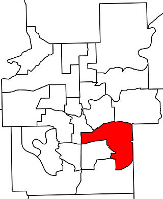
Edmonton Mill Creek was a provincial electoral district in Alberta, Canada, mandated to return a single member to the Legislative Assembly of Alberta using the first past the post method of voting from 1997 to 2019.

Macleod was a federal electoral district in Alberta, Canada, that was represented in the House of Commons of Canada from 1908 to 1968 and from 1988 to 2015. It was a mostly rural riding in southwest Alberta, however it extended as far north as the outer suburbs of Calgary, and in its final years included a few slivers of Calgary itself. It covered the Municipal District of Foothills No. 31, Municipal District of Willow Creek No. 26, Municipal District of Pincher Creek No. 9, Municipal District of Ranchland No. 66, Vulcan County, the Municipality of Crowsnest Pass, and Kananaskis Improvement District. It also included the towns of Okotoks, Cochrane, and High River.
Cardston-Chief Mountain was a provincial electoral district in Alberta, Canada, mandated to return a single member to the Legislative Assembly of Alberta using the first-past-the-post method of voting from 1993 to 1997.
Macleod was a provincial electoral district in Alberta, Canada, mandated to return a single member to the Legislative Assembly of Alberta from 1905 to 1993.

Division No. 3 is a census division in Alberta, Canada. It is located in the southwest corner of southern Alberta and its largest urban community is the Town of Claresholm.

Adams Lake Provincial Park is a provincial park in British Columbia, Canada. It encompasses three distinct parks: Adams Lake Provincial Park, Adams Lake Marine Provincial Park, and Adams Lake Marine Provincial Park.

Shuswap Lake Provincial Park is a provincial park in British Columbia, Canada.
There are several lakes named Mud Lake within the Canadian province of Alberta.

Beaver River is a large river in east-central Alberta and central Saskatchewan, Canada. It flows east through Alberta and Saskatchewan and then turns sharply north to flow into Lac Île-à-la-Crosse on the Churchill River which flows into Hudson Bay.
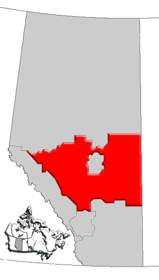
Central Alberta is a region located in the Canadian province of Alberta.
Woolford is a hamlet in southern Alberta, Canada within Cardston County. It is located on Highway 503, approximately 16 kilometres (9.9 mi) southeast of Cardston between the St. Mary River and the Milk River Ridge. It is named after Thomas Woolford who came to the area in 1900.
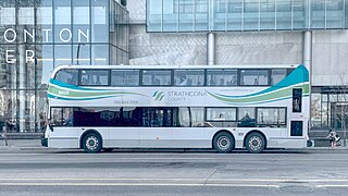
Strathcona County Transit provides local, commuter, and school bus services to the community of Sherwood Park, Alberta, Canada, which is east of Edmonton in Strathcona County. Transportation for elderly citizens and people with disabilities is provided by Mobility Bus within Sherwood Park and rural Strathcona County. Strathcona County is home to Alberta's first fleet of double-decker buses. It purchased 24 double-decker buses from 2010 to 2020 using a combination of municipal, provincial, and federal funding. In 2022, the system had a ridership of 847,300.
Pincher Creek was a provincial electoral district in Alberta, Canada, mandated to return a single member to the Legislative Assembly of Alberta from 1905 to 1940.
Edmonton-Sherwood Park was a provincial electoral district in Alberta, Canada, mandated to return a single member to the Legislative Assembly of Alberta using the first past the post method of voting from 1979 to 1986.
Marten Beach is a hamlet in northern Alberta, Canada within the Municipal District of Lesser Slave River No. 124. It is located on the northeast shore of Lesser Slave Lake, 2 kilometres (1.2 mi) west of Highway 88. It is approximately 36 kilometres (22 mi) north of the Town of Slave Lake and 238 kilometres (148 mi) northwest of the City of Edmonton.

Piikani 147, formerly Peigan 147, is an Indian reserve of the Piikani Nation in Alberta. It is located 61 km (38 mi) west of the City of Lethbridge. It has a land area of 426.992 km2 (164.863 sq mi), making it the fourth-largest Indian reserve in Canada, and lies at an elevation of 1,046 m (3,432 ft). The Canada 2011 Census reported a population of 1,217 inhabitants. It is bordered by the Municipal District of Willow Creek No. 26 on its north and east, and by the Municipal District of Pincher Creek No. 9 on its west and south. The nearest outside communities are Fort Macleod and Pincher Creek.

Peigan Timber Limit 147B is an Indian reserve of the Piikani Nation in Alberta, located within the Municipal District of Willow Creek No. 26.