Browning, Montana | |
---|---|
Coordinates: 48°33′25″N113°0′52″W / 48.55694°N 113.01444°W | |
Country | United States |
State | Montana |
County | Glacier |
Area | |
• Total | 0.28 sq mi (0.72 km2) |
• Land | 0.28 sq mi (0.72 km2) |
• Water | 0.00 sq mi (0.00 km2) |
Elevation | 4,377 ft (1,334 m) |
Population (2020) | |
• Total | 1,018 |
• Density | 3,688.41/sq mi (1,422.32/km2) |
Time zone | UTC-7 (Mountain (MST)) |
• Summer (DST) | UTC-6 (MDT) |
ZIP code | 59417 |
Area code | 406 |
FIPS code | 30-10375 |
GNIS feature ID | 0802063 |
Website | www.BrowningMontana.com |
Browning is a former town and current unincorporated community in Glacier County, Montana, United States. It is the headquarters for the Blackfeet Indian Reservation and was the only incorporated town on the Reservation. The population was 1,018 at the 2020 census. [2]
The town was named in 1885 for Commissioner of Indian Affairs Daniel M. Browning. [3] [4] The post office was established in 1895. [5] The town was disincorporated on September 26, 2018, after the town's government collapsed financially. [6] [7]
According to the United States Census Bureau, the town has a total area of 0.27 square miles (0.70 km2), all land. [8]
Browning has a warm-summer humid continental climate (Dfb), bordering on a subarctic climate, as well as cold semi-arid. From January 23 to January 24, 1916, the temperature fell 100 °F (56 °C), from 44 °F (7 °C) to −56 °F (−49 °C), the world record for greatest temperature drop in 24 hours. [9] Browning's climate is semi-arid and continental. Temperatures above 90 °F (32 °C) occur an average of twice annually, temperatures below 32 °F (0 °C) occur an average of 196 days annually, and those below 0 °F (−18 °C) occur an average of 32 days annually. There is a large degree of diurnal temperature variation that occurs in the summer, but not as much in the winter. Large temperature swings are possible, especially in fall, winter, and spring. Arctic-air intrusions from western Canada can bring sudden, severe temperature drops, while chinook events, with Pacific-originating warmer air descending from mountain ranges to the west, can result in dramatic temperature rises. Precipitation averages just over 14 inches per year, rendering the climate semi-arid. From November to March or April, the precipitation is primarily snow. Average monthly precipitation is lowest in winter and highest in the warm season. On average, June is the wettest month, with showers and thunderstorms most likely among all months.
Climate data for Browning (1894-1989) | |||||||||||||
---|---|---|---|---|---|---|---|---|---|---|---|---|---|
Month | Jan | Feb | Mar | Apr | May | Jun | Jul | Aug | Sep | Oct | Nov | Dec | Year |
Record high °F (°C) | 66 (19) | 68 (20) | 72 (22) | 91 (33) | 93 (34) | 100 (38) | 99 (37) | 102 (39) | 94 (34) | 83 (28) | 72 (22) | 69 (21) | 102 (39) |
Mean daily maximum °F (°C) | 28.2 (−2.1) | 31.9 (−0.1) | 38.0 (3.3) | 50.5 (10.3) | 60.7 (15.9) | 68.1 (20.1) | 77.8 (25.4) | 76.0 (24.4) | 65.4 (18.6) | 55.2 (12.9) | 40.2 (4.6) | 32.2 (0.1) | 52.0 (11.1) |
Mean daily minimum °F (°C) | 8.0 (−13.3) | 11.2 (−11.6) | 16.9 (−8.4) | 27.3 (−2.6) | 35.5 (1.9) | 41.8 (5.4) | 46.1 (7.8) | 44.4 (6.9) | 37.5 (3.1) | 30.9 (−0.6) | 19.9 (−6.7) | 13.3 (−10.4) | 27.7 (−2.4) |
Record low °F (°C) | −56 (−49) | −46 (−43) | −38 (−39) | −14 (−26) | 1 (−17) | 21 (−6) | 24 (−4) | 19 (−7) | 0 (−18) | −17 (−27) | −39 (−39) | −47 (−44) | −56 (−49) |
Average precipitation inches (mm) | 0.81 (21) | 0.70 (18) | 0.81 (21) | 1.09 (28) | 2.00 (51) | 2.77 (70) | 1.51 (38) | 1.39 (35) | 1.53 (39) | 0.83 (21) | 0.81 (21) | 0.72 (18) | 14.97 (381) |
Average snowfall inches (cm) | 9.5 (24) | 8.3 (21) | 8.9 (23) | 6.6 (17) | 2.3 (5.8) | 0.4 (1.0) | 0.1 (0.25) | 0.1 (0.25) | 2.6 (6.6) | 4.2 (11) | 7.4 (19) | 9.1 (23) | 59.5 (151.9) |
Source: [10] |
Census | Pop. | Note | %± |
---|---|---|---|
1920 | 986 | — | |
1930 | 1,172 | 18.9% | |
1940 | 1,825 | 55.7% | |
1950 | 1,691 | −7.3% | |
1960 | 2,011 | 18.9% | |
1970 | 1,700 | −15.5% | |
1980 | 1,226 | −27.9% | |
1990 | 1,170 | −4.6% | |
2000 | 1,065 | −9.0% | |
2010 | 1,016 | −4.6% | |
2020 | 1,018 | 0.2% | |
U.S. Decennial Census [11] [2] |
As of the census [12] of 2010, there were 1,016 people, 360 households, and 243 families living in the town. The population density was 3,763.0 inhabitants per square mile (1,452.9/km2). There were 394 housing units at an average density of 1,459.3 per square mile (563.4/km2). The racial makeup of the town was 5.5% White, 92.7% Native American, and 1.8% from two or more races. Hispanic or Latino of any race were 3.7% of the population.
There were 360 households, of which 45.3% had children under the age of 18 living with them, 28.6% were married couples living together, 28.6% had a female householder with no husband present, 10.3% had a male householder with no wife present, and 32.5% were non-families. 27.2% of all households were made up of individuals, and 8% had someone living alone who was 65 years of age or older. The average household size was 2.82 and the average family size was 3.43.
The median age in the town was 29.8 years. 33.1% of residents were under the age of 18; 9.6% were between the ages of 18 and 24; 23.6% were from 25 to 44; 23% were from 45 to 64; and 10.7% were 65 years of age or older. The gender makeup of the town was 46.1% male and 53.9% female.
Languages (2000) [13] | Percent |
---|---|
Spoke English at home | 90.76% |
Spoke Blackfoot at home | 9.24% |
As of the census [14] of 2000, there were 1,065 people, 360 households, and 254 families living in the town. The population density was 3,911.2 inhabitants per square mile (1,510.1/km2). There were 409 housing units at an average density of 1,502.0 per square mile (579.9/km2). The racial makeup of the town was 6.57% White, 90.52% Native American, 0.09% from other races, African American, 0.09% and 2.72% from two or more races. Hispanic or Latino of any race were 1.88% of the population.
There were 360 households, out of which 39.2% had children under the age of 18 living with them, 36.7% were married couples living together, 25.3% had a female householder with no husband present, and 29.2% were non-families. 27.2% of all households were made up of individuals, and 8.9% had someone living alone who was 65 years of age or older. The average household size was 2.81 and the average family size was 3.40.
In the town, the population was spread out, with 31.5% under the age of 18, 10.3% from 18 to 24, 28.1% from 25 to 44, 18.1% from 45 to 64, and 12.0% who were 65 years of age or older. The median age was 31 years. For every 100 females, there were 83.0 males. For every 100 females age 18 and over, there were 77.2 males.
The median income for a household in the town was $23,879, and the median income for a family was $25,000. Males had a median income of $24,375 versus $20,972 for females. The per capita income for the town was $8,955. About 28.3% of families and 29.2% of the population were below the poverty line, including 33.4% of those under age 18 and 23.6% of those age 65 or over.
The area school district is Browning Public Schools, [15] with its components being Browning Elementary School District and Browning High School District. [16] The two districts, under the name "Browning Public Schools," educate students from kindergarten through 12th grade. [17] They are known as the Indians. [18] Browning High School is a Class A school.
Browning is home to Blackfeet Community College.
Browning is home to low-power radio station KBWG-LP, broadcasting at 107.5 FM. [19]
The Glacier Reporter is a newspaper serving Browning and all of Glacier County. It is offered both in print and online. [20]
Browning is the setting for the TV-series The X-Files episode "Shapes".
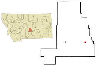
Glacier County is located in the U.S. state of Montana. As of the 2020 census, the population was 13,778. The county is located in northwestern Montana between the Great Plains and the Rocky Mountains, known to the Blackfeet as the "Backbone of the World". The county is geographically and culturally diverse and includes the Blackfeet Indian Reservation, Glacier National Park, and Lewis and Clark National Forest. The county is bordered by 75 miles of international boundary with two ports of entry open year-round and one seasonal international border crossing into Alberta, Canada.
Fromberg is a town in Carbon County, Montana, United States. As of the 2020 census, the population of the town was 392.
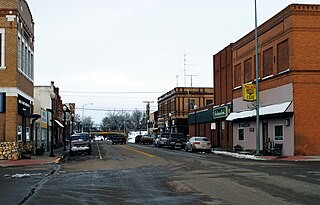
Belt is a town in Cascade County, Montana, United States. The population was 510 according to the 2020 census. It is part of the Great Falls, Montana metropolitan area.
Sun River is a census-designated place (CDP) in Cascade County, Montana, United States. The population was 124 at the 2010 census. It is part of the Great Falls, Montana Metropolitan Statistical Area.
Loma is a census-designated place (CDP) in Chouteau County, Montana, United States. The population was 85 at the 2010 census.
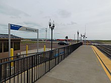
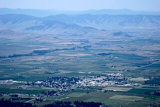
Cut Bank is a city in and the county seat of Glacier County, Montana, United States, located just east of the "cut bank" (gorge) along Cut Bank Creek. The population was 3,056 at the 2020 census, The town began in 1891 with the arrival of the Great Northern Railway.
East Glacier Park is an unincorporated community and census-designated place (CDP) in Glacier County, Montana, United States. As of the 2020 census, it had a population of 354.
North Browning is a census-designated place (CDP) in Glacier County, Montana, United States. The population was 2,408 at the 2010 census.
South Browning is a census-designated place (CDP) in Glacier County, Montana, United States. The population was 1,785 at the 2010 census. South Browning is a rural village on the Blackfeet Indian Reservation. It is bordered to the north by the town of Browning.
Starr School is a census-designated place (CDP) in Glacier County, Montana, United States. The population was 252 at the 2010 census.
Lavina is a town in Golden Valley County, Montana, United States. The population was 136 at the 2020 census. The town is situated on the north bank of the Musselshell River.
St. Ignatius is a town in Lake County, Montana, United States. The population was 768 at the 2020 census. The town is located on the Flathead Indian Reservation.
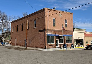
Chester is a town in and the county seat of Liberty County, Montana, United States. The population was 847 at the time of both the 2010 and 2020 U.S. Census.
Saco is a town in Phillips County, Montana, United States. The population was 159 at the 2020 census.
Broadus is a town in and the county seat of Powder River County, Montana, United States. The population was 456 at the 2020 census.
Elliston is a census-designated place (CDP) in Powell County, Montana, United States. The population was 225 at the 2000 census.
Medicine Lake is a town in Sheridan County, Montana, United States. The population was 244 at the 2020 census.
Wibaux is a town in and the county seat of Wibaux County, Montana, United States. It is the only incorporated town in Wibaux County. The population was 462 at the 2020 census.
Ronan is a city in Lake County, Montana, United States. It is on the Flathead Indian Reservation. The population was 1,955 at the 2020 census.
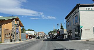
Eureka is a town in Lincoln County, Montana, United States, 9 miles (14 km) south of the Canada–US border. The population was 1,380 at the 2020 census.