Arlington, Oregon

Last updated

Arlington, Oregon
Arlington Oregon.jpg
Community of Arlington
Gilliam County Oregon Incorporated and Unincorporated areas Arlington Highlighted.svg
Location in Oregon
Coordinates: 45°42′54″N120°11′59″W / 45.71500°N 120.19972°W / 45.71500; -120.19972
Country United States
State Oregon
County Gilliam
Incorporated 1885
Government
   Mayor Jeff Bufton[ citation needed ]
Area
[1]
  Total3.17 sq mi (8.21 km2)
  Land2.55 sq mi (6.60 km2)
  Water0.62 sq mi (1.61 km2)
Elevation
[2]
285 ft (87 m)
Population
 (2020) [3]
  Total628
  Density246.27/sq mi (95.10/km2)
Time zone UTC-8 (Pacific)
  Summer (DST) UTC-7 (Pacific)
ZIP codes
97812, 97861
Area code 541
FIPS code 41-02800 [4]
GNIS feature ID2409730 [2]
Website https://www.cityofarlingtonoregon.com/

Arlington is a city in Gilliam County, Oregon, United States. The city's population was 586 at the 2010 census [5] and has a 2019 estimate of 591. [6]

Contents

History

The account of how the city received its name varies; one tradition claims it was named after the lawyer Nathan Arlington Cornish, while another tradition claims that the Southern inhabitants of the city had enough clout to rename the city after Arlington, Virginia, home of general Robert E. Lee. Originally named Alkali, Arlington came into existence as a place for shipping cattle down the Columbia River. It was incorporated as Arlington by the Oregon Legislative Assembly on November 20, 1885. [7]

Following the completion of the John Day Dam, the original location of Arlington was moved to higher ground in 1963 to avoid the resulting inundation.

In 2008, it was discovered that Mayor Carmen Kontur-Gronquist had posted photos of herself in lingerie online, [8] which, along with several other issues, led to her recall from office. [9]

Geography

According to the United States Census Bureau, the city has a total area of 2.4 square miles (6.22 km2), of which, 1.78 square miles (4.61 km2) is land and 0.62 square miles (1.61 km2) is water. [10]

Climate

According to the Köppen Climate Classification system, Arlington has a semi-arid climate, abbreviated "BSk" on climate maps. [11]

Climate data for Arlington, Oregon, 1991–2020 normals, extremes 1893–present
MonthJanFebMarAprMayJunJulAugSepOctNovDecYear
Record high °F (°C)66
(19)
74
(23)
81
(27)
97
(36)
107
(42)
117
(47)
114
(46)
115
(46)
104
(40)
90
(32)
84
(29)
74
(23)
117
(47)
Mean maximum °F (°C)56.2
(13.4)
59.4
(15.2)
67.8
(19.9)
79.3
(26.3)
90.2
(32.3)
96.4
(35.8)
103.4
(39.7)
102.1
(38.9)
93.8
(34.3)
79.9
(26.6)
65.4
(18.6)
56.7
(13.7)
104.8
(40.4)
Mean daily maximum °F (°C)40.8
(4.9)
46.9
(8.3)
55.6
(13.1)
63.7
(17.6)
73.2
(22.9)
79.7
(26.5)
89.5
(31.9)
88.9
(31.6)
80.0
(26.7)
65.5
(18.6)
50.4
(10.2)
41.1
(5.1)
64.6
(18.1)
Daily mean °F (°C)35.3
(1.8)
38.7
(3.7)
45.6
(7.6)
52.8
(11.6)
61.7
(16.5)
68.2
(20.1)
76.3
(24.6)
75.5
(24.2)
66.5
(19.2)
53.7
(12.1)
42.4
(5.8)
35.5
(1.9)
54.4
(12.4)
Mean daily minimum °F (°C)29.7
(−1.3)
30.6
(−0.8)
35.7
(2.1)
42.0
(5.6)
50.1
(10.1)
56.6
(13.7)
63.2
(17.3)
62.0
(16.7)
53.1
(11.7)
42.0
(5.6)
34.4
(1.3)
29.9
(−1.2)
44.1
(6.7)
Mean minimum °F (°C)15.4
(−9.2)
18.3
(−7.6)
24.8
(−4.0)
31.1
(−0.5)
37.0
(2.8)
46.2
(7.9)
52.6
(11.4)
51.0
(10.6)
40.9
(4.9)
28.4
(−2.0)
20.9
(−6.2)
16.7
(−8.5)
8.9
(−12.8)
Record low °F (°C)−18
(−28)
−21
(−29)
7
(−14)
19
(−7)
26
(−3)
37
(3)
42
(6)
40
(4)
26
(−3)
11
(−12)
−5
(−21)
−12
(−24)
−21
(−29)
Average precipitation inches (mm)1.47
(37)
0.98
(25)
0.83
(21)
0.61
(15)
0.75
(19)
0.48
(12)
0.10
(2.5)
0.15
(3.8)
0.33
(8.4)
0.81
(21)
1.13
(29)
1.66
(42)
9.30
(236)
Average snowfall inches (cm)2.0
(5.1)
1.2
(3.0)
0.2
(0.51)
0.0
(0.0)
0.0
(0.0)
0.0
(0.0)
0.0
(0.0)
0.0
(0.0)
0.0
(0.0)
0.1
(0.25)
0.4
(1.0)
1.4
(3.6)
5.3
(13.46)
Average precipitation days (≥ 0.01 in)11.28.18.56.16.53.51.01.72.56.89.711.477.0
Average snowy days (≥ 0.1 in)1.71.40.20.00.00.00.00.00.00.00.31.85.4
Source 1: NOAA [12]
Source 2: National Weather Service [13]

Demographics

Historical population
CensusPop.Note
1890 356
1900 3889.0%
1910 317−18.3%
1920 52966.9%
1930 60113.6%
1940 6091.3%
1950 68612.6%
1960 643−6.3%
1970 375−41.7%
1980 52138.9%
1990 425−18.4%
2000 52423.3%
2010 58611.8%
2020 6287.2%
U.S. Decennial Census [14] [3]
Park in Arlington, looking towards the Columbia River DSCN6633 arlingtonoregonelevator e.jpg
Park in Arlington, looking towards the Columbia River

2010 census

As of the census [15] of 2010, there were 586 people, 256 households, and 149 families residing in the city. The population density was 329.2 inhabitants per square mile (127.1/km2). There were 315 housing units at an average density of 177.0 per square mile (68.3/km2). The racial makeup of the city was 93.2% White, 0.2% African American, 1.0% Native American, 0.2% Asian, 2.2% Pacific Islander, 2.6% from other races, and 0.7% from two or more races. Hispanic or Latino of any race were 6.7% of the population.

There were 256 households, of which 30.1% had children under the age of 18 living with them, 45.7% were married couples living together, 8.2% had a female householder with no husband present, 4.3% had a male householder with no wife present, and 41.8% were non-families. 32.0% of all households were made up of individuals, and 8.9% had someone living alone who was 65 years of age or older. The average household size was 2.29 and the average family size was 2.92.

The median age in the city was 43.6 years. 21.8% of residents were under the age of 18; 4.8% were between the ages of 18 and 24; 24.9% were from 25 to 44; 32.9% were from 45 to 64; and 15.5% were 65 years of age or older. The gender makeup of the city was 53.9% male and 46.1% female.

2000 census

As of the census [4] of 2000, there were 524 people, 223 households, and 144 families residing in the city. The population density was 295.2 inhabitants per square mile (114.0/km2). There were 277 housing units at an average density of 156.0 per square mile (60.2/km2). The racial makeup of the city was 95.42% White, 1.72% Native American, 1.72% from other races, and 1.15% from two or more races. Hispanic or Latino of any race were 3.24% of the population.

There were 223 households, out of which 31.4% had children under the age of 18 living with them, 53.8% were married couples living together, 7.2% had a female householder with no husband present, and 35.4% were non-families. 30.0% of all households were made up of individuals, and 8.5% had someone living alone who was 65 years of age or older. The average household size was 2.35 and the average family size was 2.96.

In the city, the population was spread out, with 26.5% under the age of 18, 5.9% from 18 to 24, 28.1% from 25 to 44, 25.4% from 45 to 64, and 14.1% who were 65 years of age or older. The median age was 38 years. For every 100 females, there were 102.3 males. For every 100 females age 18 and over, there were 93.5 males.

The median income for a household in the city was $35,714, and the median income for a family was $45,875. Males had a median income of $34,250 versus $21,161 for females. The per capita income for the city was $17,883. About 7.9% of families and 10.1% of the population were below the poverty line, including 15.6% of those under age 18 and 9.7% of those age 65 or over.

Economy

Aerial view of Arlington, 2015 Aerial view of Arlington, OR 01.jpg
Aerial view of Arlington, 2015

Arlington is home to a sizable Waste Management landfill, notably receiving all of Seattle, Washington's trash and some from Portland, Oregon. [16] In March 2010, Waste Management announced [17] their plans to build a waste gasification plant next to their landfill that uses a plasma gasification technology that at the time was considered experimental. The plasma gasification plant was built in conjunction with the company, InEnTec, whose efforts to build such plants in California and elsewhere have met protest. [18] The plant went into pilot operation in November 2011. [19] [20]

The area around Arlington is largely agricultural farm land with wheat, barley and beef cattle being the principal products.

The area around Arlington is the location of several wind farms:

StationLocationCapacity (MW)StatusNotesNo. of turbines
Willow Creek Wind Farm Gilliam County and Morrow County 72Operational [21] 48
Shepherds Flat Wind Farm Gilliam County and Morrow County 845Operational [22] [23] [24] 338
Rattlesnake Road Wind Farm Gilliam County 103Operational [25] 49
Leaning Juniper Wind Project Gilliam County 302.3Operational [26] [27] 200
Pebble Springs Wind Farm Gilliam County 99Operational [28] 47
Wheatfield Wind Farm Gilliam County 97Operational [29] 46
Montague Wind Power Facility Gilliam County Phase 1 - 201 (Proposed - 404)Operational [30] [31] [32] [33] [34] [35] [36] [37] Phase 1 - 56

112-269

Saddle Butte Wind - Four Mile Wind Gilliam County and Morrow County 399Proposed [38] [39] 133
2Morrow Energy Gilliam County and Morrow County 900Proposed [40]
Montague Wind Project under construction. H3 Montague Wind Power Project.jpg
Montague Wind Project under construction.

Caithness Energy has the Shepherds Flat Wind Farm, one of the largest land-based wind farms in the world. Approved in 2008 by state regulators, groundbreaking came in 2009. It officially opened in September 2012 and "reached full commercial operations in November 2012." [24] There have been some controversies around the project that emerged in 2009 and 2010. [41]

In fall 2017, construction was started on the Montague Wind Power Project, a project owned and operated by Avangrid Renewables to provide power to Apple Inc.'s Prineville Data Center through Oregon's Direct Access Program. "Apple says Montague will provide it 560,000 megawatt-hours of electricity annually." [33] [36]

Along with the wind farm there have been several proposed solar farms. On April 20, 2020, Avangrid requested to change the boundary and site layout of its Montague Wind Power Facility. This request was to split "the existing site certificate into three new site certificates for facilities to be named Montague Wind, Montague Solar, and Oregon Trail Solar; and, transfer of site certificates for Montague Solar and Oregon Trail Solar to new limited liability companies, Montague Solar, LLC and Oregon Trail Solar, LLC, wholly owned subsidiaries of the current certificate holder owner, Avangrid Renewables, LLC." [42]

Notable people

Transportation

Welcome sign Sign welcoming visitors to Arlington, Oregon.jpg
Welcome sign

Arlington is located at the intersection of Interstate 84 and Oregon Route 19. I-84 travels west towards Portland and east towards Boise, Idaho; OR 19 connects Arlington to Condon and U.S. Route 26 near Dayville. [43]

The Port of Arlington [44] offers access the Columbia River water way and hosts

  1. a marina with a water depth of 24 feet that features a fuel dock and 8 transient moorage slips, 1 side tie dock, 11-30’ slips, and 7-20’ slips;
  2. Mid Columbia Producer, LLC [45] River Terminal; and
  3. a windsurfing and kiteboarding launch. [46]

The city has a small airport named Arlington Municipal Airport, located on a nearby plateau. In 2011, the U.S. Air Force proposed Arlington as the site of a future United States Department of Defense unmanned aerial vehicle base. [47] [48]

Public services

Churches

See also

Related Research Articles

<span class="mw-page-title-main">Wheeler County, Oregon</span> County in Oregon, United States

Wheeler County is a county in the U.S. state of Oregon. As of the 2020 census, the population was 1,451, making it Oregon's least populous county. It is named in honor of Henry H. Wheeler. an early settler who owned a farm near Mitchell. The county seat is Fossil, and Wheeler County is known for having Oregon's largest deposit of fossils.

<span class="mw-page-title-main">Union County, Oregon</span> County in Oregon, United States

Union County is one of the 36 counties in the U.S. state of Oregon, and one of the 8 counties of eastern Oregon. As of the 2020 census, the population was 26,196. The county comprises the La Grande micropolitan statistical area and the county seat is La Grande.

<span class="mw-page-title-main">Sherman County, Oregon</span> County in Oregon, United States

Sherman County is one of the 36 counties in the U.S. state of Oregon. As of the 2020 census, the population was 1,870, making it the second-least populous county in Oregon after nearby Wheeler. The county seat is Moro, and the largest city is Wasco. The county is named for William Tecumseh Sherman, a Union general in the American Civil War.

<span class="mw-page-title-main">Hood River County, Oregon</span> County in Oregon, United States

Hood River County is one of the 36 counties in the U.S. state of Oregon. As of the 2020 census, the population was 23,977. The county seat is Hood River. The county was established in 1908 and is named for the Hood River, a tributary of the Columbia River. Hood River County comprises the Hood River, OR Micropolitan Statistical Area. The Hood River Valley produces apples, pears, and cherries. Situated between Mount Hood and the Columbia River in the middle of the Columbia River Gorge, Hood River County is a popular destination for outdoor enthusiasts, such as windsurfers, mountain-bikers, skiers, hikers, kayakers, and many more.

<span class="mw-page-title-main">Gilliam County, Oregon</span> County in Oregon, United States

Gilliam County is one of the 36 counties in the U.S. state of Oregon. As of the 2020 census, the population was 1,995, making it the third-least populous county in Oregon. The county seat is Condon. The county was established in 1885 and is named for Cornelius Gilliam, a colonel who commanded the forces of the provisional government of Oregon after the Whitman Massacre.

<span class="mw-page-title-main">Montague, California</span> City in California, United States

Montague is a city in Siskiyou County, California, United States. Its population is 1,226 as of the 2020 census, down from 1,443 from the 2010 census.

<span class="mw-page-title-main">Philomath, Oregon</span> City in Oregon, United States

Philomath is a city in Benton County, Oregon, United States. It was named for Philomath College. The population was 4,584 at the 2010 census and was most recently estimated in 2019 to have a population of 5,666. It is part of the Corvallis, Oregon, Metropolitan Statistical Area.

<span class="mw-page-title-main">Molalla, Oregon</span> City in Oregon, United States

Molalla is a city in Clackamas County, Oregon. The population was 10,228 at the time of the 2020 census.

<span class="mw-page-title-main">Condon, Oregon</span> City in Oregon, United States

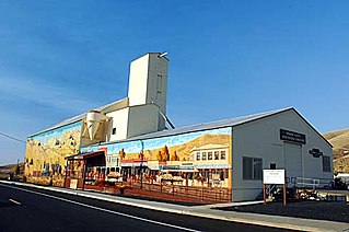
Condon is a city in, and the seat of, Gilliam County, in the U.S. state of Oregon. The population was 682 at the 2010 census. The city, with an historic main street along Oregon Route 19, is a farming and ranching community. The John Day River/Cottonwood Canyon State Park, the ghost town of Lonerock and the John Day Fossil Beds are all a short drive from Historic Condon.

<span class="mw-page-title-main">Lonerock, Oregon</span> City in Oregon, United States

Lonerock is a city in Gilliam County, Oregon, United States, twenty miles east of Condon. The population was 21 at the 2010 census.

<span class="mw-page-title-main">Heppner, Oregon</span> City in Oregon, United States

Heppner is a city in, and the county seat of, Morrow County, Oregon, United States. As of 2010, the population was 1,291. Heppner is part of the Pendleton-Hermiston Micropolitan Area. Heppner is named after Henry Heppner, a prominent Jewish-American businessman.

<span class="mw-page-title-main">Ione, Oregon</span> City in Oregon, United States

Ione is a city in Morrow County, Oregon, United States. The population was 329 at the 2010 census. It is part of the Pendleton–Hermiston Micropolitan Statistical Area.

<span class="mw-page-title-main">Lexington, Oregon</span> City in Oregon, United States

Lexington is a city in Morrow County, Oregon, United States. The population was 238 at the 2010 census. It is part of the Pendleton–Hermiston Micropolitan Statistical Area.

<span class="mw-page-title-main">Troutdale, Oregon</span> City in Oregon, United States

Troutdale is a city in Multnomah County, Oregon, United States, immediately north of Gresham and east of Wood Village. As of the 2020 census, the city population was 16,300. The city serves as the western gateway to the Historic Columbia River Highway, the Mount Hood Scenic Byway, and the Columbia River Gorge. It is approximately 12 miles (19 km) east of Portland.

<span class="mw-page-title-main">Rockaway Beach, Oregon</span> City in Oregon, United States

Rockaway Beach is a city in Tillamook County, Oregon, United States. The population was 1,312 at the 2010 census.

<span class="mw-page-title-main">Hermiston, Oregon</span> City in Oregon, United States

Hermiston is a city in Umatilla County, Oregon, United States. Its population of 20,322 makes it the largest city in Eastern Oregon. Hermiston is the largest and fastest-growing city in the Hermiston-Pendleton Micropolitan Statistical Area, the eighth largest Core Based Statistical Area in Oregon with a combined population of 92,261 at the 2020 census. Hermiston sits near the junction of I-82 and I-84, and is 7 miles south of the Columbia River, Lake Wallula, and the McNary Dam. The Hermiston area has become a hub for logistics and data center activity due to the proximity of the I-82 and I-84 interchange, Pacific Northwest fiber optic backbone, and low power costs.

<span class="mw-page-title-main">The Dalles, Oregon</span> City in the United States

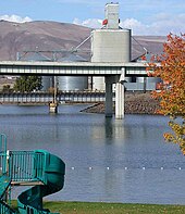
The Dalles, formally the City of The Dalles and also called Dalles City, is an inland port and the largest city in Wasco County, Oregon, United States. The population was 16,010 at the 2020 census, and it is the largest city in Oregon along the Columbia River outside the Portland Metropolitan Area. The Dalles is 75 miles east of Portland, within the Columbia River Gorge National Scenic Area.

<span class="mw-page-title-main">Wind power in Oregon</span> Electricity from wind in one U.S. state

The U.S. state of Oregon has large wind energy resources. Many projects have been completed, most of them in rural Eastern Oregon and near the Columbia River Gorge. Wind power accounted for 12.1% of the electricity generated in Oregon in 2016.

<span class="mw-page-title-main">Shepherds Flat Wind Farm</span> Wind farm in Oregon, USA

The Shepherds Flat Wind Farm is an 845 megawatt (MW) wind farm in the eastern part of U.S. state of Oregon, near Arlington, in both Gilliam and Morrow counties. Groundbreaking occurred in 2009, and it officially opened in September 2012.

References

  1. "ArcGIS REST Services Directory". United States Census Bureau. Retrieved October 12, 2022.
  2. 1 2 U.S. Geological Survey Geographic Names Information System: Arlington, Oregon
  3. 1 2 "Census Population API". United States Census Bureau. Retrieved October 12, 2022.
  4. 1 2 "U.S. Census website". United States Census Bureau. Retrieved January 31, 2008.
  5. American FactFinder - Results [ dead link ]
  6. "2019: ACS 5-Year Estimates Data Profiles". data.census.gov. Retrieved December 16, 2020.
  7. Leeds, W. H. (1899). "Special Laws". The State of Oregon General and Special Laws and Joint Resolutions and Memorials Enacted and Adopted by the Twentieth Regular Session of the Legislative Assembly. Salem, Oregon: State Printer: 702.
  8. "Mayor's racy photos become the talk of the town". KATU. January 7, 2008. Archived from the original on January 8, 2008. Retrieved January 8, 2008.
  9. "Mayor who posed in underwear loses office". Komo TV. Associated Press. February 26, 2008. Archived from the original on February 28, 2008. Retrieved February 26, 2008.
  10. "US Gazetteer files 2010". United States Census Bureau. Archived from the original on January 25, 2012. Retrieved December 21, 2012.
  11. Climate Summary for Arlington, Oregon
  12. "U.S. Climate Normals Quick Access – Station: Arlington, OR". National Oceanic and Atmospheric Administration. Retrieved April 15, 2023.
  13. "NOAA Online Weather Data – NWS Pendleton". National Weather Service. Retrieved April 15, 2023.
  14. "Census of Population and Housing". Census.gov. Retrieved June 4, 2015.
  15. "U.S. Census website". United States Census Bureau. Retrieved December 21, 2012.
  16. Mulady, Kathy (July 10, 2007). "Where your Seattle trash ends up". Seattle Post-Intelligencer . Retrieved April 6, 2008.[ dead link ]
  17. announced
  18. fierce protest
  19. Wolman, David (January 20, 2012). "High-Powered Plasma Turns Garbage Into Gas". Wired . Retrieved December 4, 2016.
  20. Surma, Jeff (January 27, 2012). "Gasification of Municipal Solid Waste Using the InEnTec InEnTec Plasma Enhanced Melter" (PDF). Archived from the original (PDF) on December 20, 2016. Retrieved December 4, 2016.
  21. "Willow Creek | Renewable Northwest". renewablenw.org. Retrieved March 14, 2019.
  22. "Caithness Shepherds Flat Wind Farm" . Retrieved March 14, 2019.
  23. "World's Largest Wind Farm Coming to Oregon". Portland Business Journal. December 10, 2009. Retrieved January 16, 2010.
  24. 1 2 "SHEPHERDS FLAT". Energy.gov. Retrieved March 14, 2019.
  25. "Oregon | Rattlesnake Road Wind Farm". rattlesnakeroadwindfarm.com. Retrieved March 14, 2019.
  26. "Leaning Juniper I". www.pacificorp.com. Archived from the original on June 28, 2019. Retrieved March 14, 2019.
  27. "Leaning Juniper II". www.pacificpower.net. Archived from the original on March 10, 2019. Retrieved March 14, 2019.
  28. "Pebble Springs Wind | Renewable Northwest". renewablenw.org. Retrieved March 14, 2019.
  29. "Wheat Field Wind Farm | Renewable Northwest". renewablenw.org. Retrieved March 14, 2019.
  30. "Montague Wind Power Facility | Renewable Northwest". renewablenw.org. Retrieved March 14, 2019.
  31. Rogoway, Mike (April 24, 2017). "Apple says new Oregon solar and wind projects will help power Prineville data centers". OregonLive. Retrieved 2024-05-28.
  32. Danko, Pete (May 19, 2017). "Apple's Oregon Wind Farm Eyes Bigger, and Fewer, Turbines". Portland Business Journal. Retrieved 2024-05-28.
  33. 1 2 Sellers, Dennis (May 19, 2017). "Apple's wind farm project developer wants bigger, but fewer, turbines". Apple World Today. Retrieved 2024-05-28.
  34. Danko, Pete (July 18, 2017). "Apple's Oregon wind farm cleared for super-sized turbines". Portland Business Journal. Retrieved 2024-05-28.
  35. Sellers, Dennis (July 20, 2017). "Apple's Oregon wind power project to use the biggest turbines ever deployed in the area". Apple World Today. Retrieved 2024-05-28.
  36. 1 2 Danko, Pete (September 14, 2017). "Apple Inc.'s Massive Oregon Wind Farm Breaks Ground". Portland Business Journal. Retrieved 2024-05-28.
  37. "AVANGRID Reports Third Quarter 2019 Earnings". Avangrid. October 29, 2019. Retrieved 2024-05-28.
  38. "Saddle Butte Wind | Renewable Northwest". renewablenw.org. Retrieved March 14, 2019.
  39. "State of Oregon: Facilities - Saddle Butte Wind Park". www.oregon.gov. Retrieved March 14, 2019.
  40. "2Morrow Energy | Renewable Northwest". renewablenw.org. Retrieved March 14, 2019.
  41. Schmit, Julie (December 10, 2009). "GE gets contract for big wind farm in Oregon". USA Today. Retrieved 2024-05-28.
  42. "State of Oregon: Facilities - Montague Wind Power Facility". www.oregon.gov. Retrieved May 25, 2020.
  43. Oregon 2017–2019 Official State Map (PDF) (Map). Oregon Department of Transportation. March 2017. Retrieved August 21, 2019, with inset maps.
  44. Port of Arlington
  45. Mid Columbia Producer, llc
  46. "WPS - Waterway Systems - Columbia River System Port Map". World Port Source. Retrieved May 25, 2020.
  47. HQ AFSC/SEFQ Lt Col (Maggie) Howard Chief, RPA Branch CNS/ATM Conference-June 13, 2011 "Air Force Safety Center RPA Branch Presentation" Archived 2016-12-31 at the Wayback Machine (PDF), 2011 Air Force Presentation
  48. "Revealed: 64 Drone Bases on American Soil"
  49. Arlington United Methodist Church
  50. Arlington Church of the Nazarene
  51. St. Francis Catholic Church