Dayville, Oregon

Last updated

Dayville, Oregon
Dayville, OR -- Dayville City Hall (PNG).png
City Hall
Grant County Oregon Incorporated and Unincorporated areas Dayville Highlighted.svg
Location in Oregon
Coordinates: 44°28′00″N119°31′56″W / 44.46667°N 119.53222°W / 44.46667; -119.53222
Country United States
State Oregon
County Grant
Incorporated 1913
Government
   Mayor Peter Bogardus[ citation needed ]
Area
[1]
  Total0.53 sq mi (1.36 km2)
  Land0.53 sq mi (1.36 km2)
  Water0.00 sq mi (0.00 km2)
Elevation
[2]
2,346 ft (715 m)
Population
 (2020) [3]
  Total132
  Density250.95/sq mi (96.96/km2)
Time zone UTC-8 (Pacific)
  Summer (DST) UTC-7 (Pacific)
ZIP Code
97825
Area code 541
FIPS code 41-18300 [4]
GNIS feature ID2412411 [2]

Dayville is a city along U.S. Route 26 in Grant County, in the U.S. state of Oregon. It was incorporated in 1913. The population was 149 at the 2010 census.

Contents

History

Dayville was named for the John Day River. [5] The original site of the Dayville post office was 3 miles (5 km) west of the city's current location. [5] In the mid-19th century, Dayville was along the route of a wagon road, renamed The Dalles Military Road in about 1870, that connected The Dalles on the Columbia River with gold mines near Canyon City. [6] Dayville was incorporated in 1913. [7]

Geography

Dayville welcome sign Dayville, Oregon Welcome Sign (37146635933).jpg
Dayville welcome sign

The city is 125 miles (201 km) east of Bend and 233 miles (375 km) southeast of Portland, [8] at the confluence of the John Day River with the South Fork John Day River. U.S. Route 26 runs eastwest through Dayville, and South Fork Road, which runs northsouth along the smaller river, meets the larger highway in the city. Murderers Creek State Wildlife Area, the Aldrich Mountains, and parts of the Malheur National Forest are slightly southeast of Dayville. Slightly southwest are the Black Canyon Wilderness, the Ochoco Mountains, and parts of the Ochoco National Forest. [9]

Picture Gorge, named for Native American pictographs painted on the canyon walls, is 6 miles (10 km) northwest of Dayville at the intersection of Route 26 and Oregon Route 19. The Sheep Rock Unit of the John Day Fossil Beds National Monument, including the Thomas Condon Paleontology Center and the James Cant Ranch Historic District and museum, are 2 miles (3 km) north of Picture Gorge along Route 19. [10]

According to the United States Census Bureau, the city has a total area of 0.53 square miles (1.37 km2), all land. [11]

Climate

Climate data for Dayville, Oregon, 1991–2020 normals, extremes 1978–present
MonthJanFebMarAprMayJunJulAugSepOctNovDecYear
Record high °F (°C)67
(19)
76
(24)
83
(28)
95
(35)
102
(39)
114
(46)
114
(46)
112
(44)
111
(44)
96
(36)
86
(30)
67
(19)
114
(46)
Mean maximum °F (°C)60.5
(15.8)
63.8
(17.7)
73.4
(23.0)
83.0
(28.3)
92.3
(33.5)
99.0
(37.2)
105.9
(41.1)
104.8
(40.4)
99.3
(37.4)
86.7
(30.4)
71.4
(21.9)
59.5
(15.3)
107.0
(41.7)
Mean daily maximum °F (°C)45.3
(7.4)
50.4
(10.2)
57.5
(14.2)
63.0
(17.2)
72.7
(22.6)
81.0
(27.2)
92.6
(33.7)
91.9
(33.3)
82.4
(28.0)
67.5
(19.7)
53.5
(11.9)
45.5
(7.5)
66.9
(19.4)
Daily mean °F (°C)37.1
(2.8)
39.7
(4.3)
45.5
(7.5)
50.0
(10.0)
58.1
(14.5)
65.1
(18.4)
73.6
(23.1)
72.6
(22.6)
64.7
(18.2)
53.1
(11.7)
43.0
(6.1)
36.5
(2.5)
53.3
(11.8)
Mean daily minimum °F (°C)28.8
(−1.8)
29.0
(−1.7)
33.4
(0.8)
37.1
(2.8)
43.6
(6.4)
49.2
(9.6)
54.6
(12.6)
53.3
(11.8)
47.0
(8.3)
38.7
(3.7)
32.5
(0.3)
27.4
(−2.6)
39.6
(4.2)
Mean minimum °F (°C)9.5
(−12.5)
13.1
(−10.5)
20.4
(−6.4)
24.3
(−4.3)
29.6
(−1.3)
37.3
(2.9)
43.9
(6.6)
41.1
(5.1)
34.3
(1.3)
23.0
(−5.0)
15.6
(−9.1)
10.8
(−11.8)
3.2
(−16.0)
Record low °F (°C)−12
(−24)
−12
(−24)
12
(−11)
16
(−9)
21
(−6)
28
(−2)
36
(2)
30
(−1)
24
(−4)
2
(−17)
−8
(−22)
−18
(−28)
−18
(−28)
Average precipitation inches (mm)1.12
(28)
0.85
(22)
1.27
(32)
1.38
(35)
1.95
(50)
1.38
(35)
0.53
(13)
0.54
(14)
0.56
(14)
1.09
(28)
1.32
(34)
1.14
(29)
13.13
(334)
Average snowfall inches (cm)1.2
(3.0)
0.4
(1.0)
0.3
(0.76)
0.0
(0.0)
0.0
(0.0)
0.0
(0.0)
0.0
(0.0)
0.0
(0.0)
0.0
(0.0)
0.0
(0.0)
0.0
(0.0)
1.1
(2.8)
3.0
(7.6)
Average precipitation days (≥ 0.01 in)7.56.710.810.111.17.13.42.73.26.310.56.385.7
Average snowy days (≥ 0.1 in)0.50.40.30.10.10.00.00.00.00.00.01.12.5
Source 1: NOAA [12]
Source 2: National Weather Service [13]

Demographics

Historical population
CensusPop.Note
1890 120
1900 52−56.7%
1910 10092.3%
1920 11717.0%
1930 106−9.4%
1940 13628.3%
1950 286110.3%
1960 234−18.2%
1970 197−15.8%
1980 1991.0%
1990 144−27.6%
2000 138−4.2%
2010 1498.0%
2020 132−11.4%
source: [4] [14] [3]

2010 census

As of the census of 2010, there were 149 people, 72 households, and 41 families residing in the town. The population density was 281.1 inhabitants per square mile (108.5/km2). There were 93 housing units at an average density of 175.5 per square mile (67.8/km2). The racial makeup of the town was 96.0% White, 3.4% Native American, and 0.7% from two or more races. Hispanic or Latino of any race were 0.7% of the population. [4]

There were 72 households, out of which 19.4% had children under the age of 18 living with them, 47.2% were married couples living together, 9.7% had a female householder with no husband present, and 43.1% were non-families. 38.9% of all households were made up of individuals, and 15.2% had someone living alone who was 65 years of age or older. The average household size was 2.07 and the average family size was 2.68. [4]

The median age in the town was 50.8 years. 14.8% of residents were under the age of 18; 8.1% were between the ages of 18 and 24; 16.1% were from 25 to 44; 38.3% were from 45 to 64; and 22.8% were 65 years of age or older. The gender makeup of the town was 53.7% male and 46.3% female. [4]

2000 census

As of the census of 2000, there were 138 people, 59 households, and 36 families residing in the city. The population density was 269.5 inhabitants per square mile (104.1/km2). There were 77 housing units at an average density of 150.4 per square mile (58.1/km2). The racial makeup of the city was 96.38% White, 2.17% Native American, 0.72% Asian, and 0.72% from two or more races. [4]

There were 59 households, out of which 27.1% had children under the age of 18 living with them, 49.2% were married couples living together, 11.9% had a female householder with no husband present, and 37.3% were non-families. 32.2% of all households were made up of individuals, and 10.2% had someone living alone who was 65 years of age or older. The average household size was 2.34 and the average family size was 3.05. [4]

In the city, the population was spread out, with 24.6% under the age of 18, 5.8% from 18 to 24, 24.6% from 25 to 44, 23.9% from 45 to 64, and 21.0% who were 65 years of age or older. The median age was 42 years. For every 100 females, there were 89.0 males. For every 100 females age 18 and over, there were 96.2 males. [4]

The median income for a household in the city was $30,893, and the median income for a family was $33,438. Males had a median income of $27,083 versus $25,417 for females. The per capita income for the city was $18,319. There were 12.2% of families and 16.1% of the population living below the poverty line, including 26.5% of under eighteens and none of those over 64. [4]

Economy

Dayville is home to Dayville School District, a K−12 system with a total of about 50 students in 2007. [15] As of 2002, the five largest employers in Dayville were the school district, the Dayville Merc (groceries), a cafe, a lounge, and a gas station. [8]

The Dayville Presbyterian Church [16] has since the 1970s offered hospitality to bicyclists journeying along the TransAmerica bicycle trail. [17]

Related Research Articles

<span class="mw-page-title-main">Wheeler County, Oregon</span> County in Oregon, United States

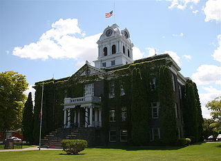
Wheeler County is a county in the U.S. state of Oregon. As of the 2020 census, the population was 1,451, making it Oregon's least populous county. It is named in honor of Henry H. Wheeler. an early settler who owned a farm near Mitchell. The county seat is Fossil, and Wheeler County is known for having Oregon's largest deposit of fossils.

<span class="mw-page-title-main">Crook County, Oregon</span> County in Oregon, United States

Crook County is one of the 36 counties in the U.S. state of Oregon. As of the 2020 census, the population was 24,738. The county seat is Prineville. The county is named after George Crook, a U.S. Army officer who served in the American Civil War and various Indian Wars.

<span class="mw-page-title-main">Canyon Day, Arizona</span> CDP in Gila County, Arizona

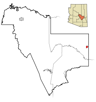
Canyon Day is a census-designated place (CDP) in Gila County, Arizona, United States, on the Fort Apache Indian Reservation. The population was 1,209 at the 2010 census.

<span class="mw-page-title-main">Homedale, Idaho</span> City in Idaho, United States

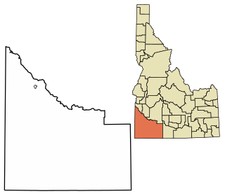
Homedale is a city in Owyhee County Idaho. The population was 2,633 at the time of the 2010 census. The town name was chosen by drawing names from a hat during a community picnic. Homedale is part of the Boise metropolitan area. It was, at one time, the terminus of a branch of the Oregon Short Line Railroad.

<span class="mw-page-title-main">Marsing, Idaho</span> City in Owhyee County, Idaho, United States

Marsing is a city in Owyhee County, Idaho, United States. The population was 1,031 at the time of the 2010 census. It is part of the Boise metropolitan area.

<span class="mw-page-title-main">Gering, Nebraska</span> City in and county seat of Scotts Bluff County, Nebraska, United States

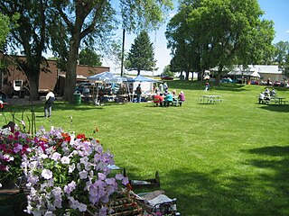
Gering is a city in and the county seat of Scotts Bluff County, Nebraska, United States, in the Panhandle region of the state. The population was 8,564 at the 2020 census, making it the 17th most populous city in Nebraska.

<span class="mw-page-title-main">Richland, Oregon</span> City in Oregon, United States

Richland is a city in Baker County, Oregon, United States. The population was 156 at the 2010 census.

<span class="mw-page-title-main">Lakeside, Oregon</span> City in Oregon, United States

Lakeside is a city in Coos County, Oregon, United States. The population was 1,699 at the 2010 census.

<span class="mw-page-title-main">John Day, Oregon</span> City in Oregon, United States

John Day is a city located approximately 2 miles (3.2 km) north of Canyon City in Grant County, Oregon, United States, at the intersection of U.S. Routes 26 and 395. The city was named for the nearby John Day River, which, along with Dayville, had been named for a Virginia member of the 1811 Astor Expedition, John Day. The city was incorporated in 1901.

<span class="mw-page-title-main">Dunes City, Oregon</span> City in Oregon, United States

Dunes City is a city in Lane County, Oregon, United States. The population was 1,303 at the 2010 census.

<span class="mw-page-title-main">Lowell, Oregon</span> City in Oregon, United States

Lowell is a city in Lane County, in the U.S. state of Oregon. As of the 2010 census, the city population was 1,045. The city is on the north shore of Dexter Reservoir on the Middle Fork Willamette River. The most used route to Lowell is along Lowell Bridge, a covered bridge that crosses the reservoir from Oregon Route 58.

<span class="mw-page-title-main">Harrisburg, Oregon</span> City in Oregon, United States

Harrisburg is a city in Linn County, Oregon, United States. The population was 3,567 at the 2010 census.

<span class="mw-page-title-main">Adrian, Oregon</span> City in Oregon, United States

Adrian is a city in Malheur County, Oregon, United States, near the confluence of the Snake River and the Owyhee River. The population was 177 at the 2010 census. It is part of the Ontario, OR–ID Micropolitan Statistical Area.

<span class="mw-page-title-main">Detroit, Oregon</span> City in Oregon, United States

Detroit is a city in Marion County, Oregon, United States. It was named for Detroit, Michigan, in the 1890s because of the large number of people from Michigan in the community. The population was 203 at the 2020 census. It is part of the Salem Metropolitan Statistical Area.

<span class="mw-page-title-main">Donald, Oregon</span> City in Oregon, United States

Donald is a city in Marion County, Oregon, United States. The population was 1,009 at the 2020 census. It is part of the Salem Metropolitan Statistical Area.

<span class="mw-page-title-main">Adams, Oregon</span> City in Oregon, United States

Adams is a city in Umatilla County, Oregon, United States, located about 13 miles (21 km) northeast of Pendleton on Oregon Route 11. The population was 350 at the 2010 census. It is part of the Pendleton–Hermiston Micropolitan Statistical Area.

<span class="mw-page-title-main">Banks, Oregon</span> City in Oregon, United States

Banks is a city in Washington County, Oregon, United States which is located in the Tualatin Valley. It is the southern anchor to the Banks–Vernonia State Trail, which is a 21-mile (34 km) long linear trail popular with bicyclists, hikers, and equestrians. The population was 1,777 at the 2010 census. The community was named for John and Nancy Banks, who owned a nearby dairy farm. Incorporated in 1921, it is located in the western part of the county where Oregon Route 6 intersects Oregon Route 47.

<span class="mw-page-title-main">Mitchell, Oregon</span> City in Oregon, United States

Mitchell is a city in Wheeler County, Oregon, United States. The population was 130 at the 2010 census. It was founded in 1873 and was named after John H. Mitchell, a politician.

<span class="mw-page-title-main">Gates, Oregon</span> City in Oregon, United States

Gates is a city on the border of Linn and Marion counties in Oregon, United States. The population was 548 at the 2020 census. The greater part of Gates' population is in Marion County and the city is primarily under Marion County's jurisdiction.

<span class="mw-page-title-main">Idanha, Oregon</span> City in Oregon, United States

Idanha is a city on the Marion County/Linn County line in Oregon, United States, on Oregon Route 22 and the Santiam River. The population was 156 at the 2020 census.

References

  1. "ArcGIS REST Services Directory". United States Census Bureau. Retrieved October 12, 2022.
  2. 1 2 U.S. Geological Survey Geographic Names Information System: Dayville, Oregon
  3. 1 2 "Census Population API". United States Census Bureau. Retrieved October 12, 2022.
  4. 1 2 3 4 5 6 7 8 9 "U.S. Census website". U.S. Census Bureau. Retrieved August 10, 2013.
  5. 1 2 McArthur, Lewis A.; McArthur, Lewis L. (2003) [1928]. Oregon Geographic Names (7th ed.). Portland, Oregon: Oregon Historical Society Press. p. 271. ISBN   978-0875952772.
  6. "Regional History". Oregon Paleo Lands Institute. 2013. Retrieved August 11, 2013.
  7. "Incorporated Cities: Dayville". Oregon Blue Book. Oregon State Archives. Retrieved January 10, 2015.
  8. 1 2 "Community Profile: Dayville". Infrastructure Finance Authority. 2009. Archived from the original on April 3, 2013. Retrieved August 10, 2013.
  9. Oregon Atlas & Gazetteer (7th ed.). Yarmouth, Maine: DeLorme. 2008. p. 77. ISBN   978-0-89933-347-2.
  10. "John Day Fossil Beds: Directions". National Park Service, U.S. Department of the Interior. Retrieved September 10, 2007.
  11. "U.S. Gazetteer: 2010, 2000, and 1990". United States Census Bureau. Retrieved August 10, 2013.
  12. "U.S. Climate Normals Quick Access – Station: Dayville 8 NW, OR". National Oceanic and Atmospheric Administration. Retrieved April 15, 2023.
  13. "NOAA Online Weather Data – NWS Pendleton". National Weather Service. Retrieved April 15, 2023.
  14. Moffatt, Riley Moore (1996). Population History of Western U.S. Cities and Towns, 1850–1990. Lanham, Maryland: Scarecrow Press. p. 208. ISBN   978-0-8108-3033-2.
  15. "Dayville School: Home of the Tigers". Dayville School. 2007. Archived from the original on August 25, 2007. Retrieved August 29, 2007.
  16. "Eastern Oregon Presbytery Congregations". Archived from the original on October 21, 2016. Retrieved November 9, 2011.
  17. "TransAmerica Trail". Adventure Cycling Association. Archived from the original on October 11, 2011. Retrieved November 9, 2011.