The James Cant Ranch is a pioneer ranch complex in Grant County in eastern Oregon, United States. The ranch is located on both sides of the John Day River in the John Day Fossil Beds National Monument. The ranch was originally homesteaded by Floyd Officer in 1890. Officer sold the property to James Cant in 1910. Cant increased the size of the property and built a modern ranch complex on the west bank of the river. The National Park Service bought the ranch from the Cant family in 1975, and incorporated the property into the John Day Fossil Beds National Monument. The National Park Service used the main house as a visitor center until 2003. Today, the Cant Ranch complex is preserved as an interpretive site showing visitors an early 20th-century livestock ranch. The James Cant Ranch is listed on the National Register of Historic Places.
Native Americans used the area around the John Day River for thousands of years before the arrival of European settlers. While boundaries were never clearly defined, the site that is now the Cant Ranch was used for seasonal hunting and fishing camps by Warm Springs and Umatilla bands, both Sahaptin speaking Columbia Plateau peoples. By the nineteenth century, Northern Paiutes had migrated north from the Great Basin and were also using portions of the upper John Day watershed.[2][3]
As a result of the arid climate, only a few trappers and prospectors traveled through the area before 1862 when gold was discovered in Canyon Creek, tributary of the John Day River. The discovery of gold drew a large number of miners to the area. This led to the founding of a number of mining towns in northeastern Oregon. The largest of these towns was Canyon City. A wagon road, formalized in 1869 as The Dalles Military Road between Fort Dalles on the Columbia River and Canyon City, encouraged additional growth.[3][4]
Permanent homesteaders began arriving in the John Day Valley shortly after the miners. The Homestead Act of 1862 encouraged settlement by offering grants of 160 acres (0.65km2) to American pioneers. Livestock operations in the John Day area supplied isolated mining towns with fresh meat. Initially, most ranches produced beef cattle. However, sheep were the primary ranch stock by the 1890s. This coincided with a wave of Scottish, Irish, and Basque immigrants who were experienced sheep herders.[3]
In 1890, Floyd Officer homesteaded land in the Butler Basin along the John Day River. He worked the property for seven years before securing a 160-acre (0.65km2)land patent in 1898. That same year, he married Sylvia Fitzgerald and together they began a hard pioneer life on their remote homestead. Because of his knowledge of the Butler Basin and Sheep Rock areas, Officer served as a guide for pioneer paleontologistThomas Condon during several of his fossil hunting expeditions. The Officers sold the ranch in 1910, moving to Dayville where their children could attend school.[5][6] The property was purchased by James Cant and his partner John Mason for $4,000. It included 357 acres (1.44km2) in Grant County and 320 adjoining acres (1.3km2) in Wheeler County. Cant bought out Mason's share in the property in 1915.[7][8]
James Cant
James Cant was born in Scotland in 1879. He left Scotland at the age of 20 for South America, where he spent five years raising horses and mules. He immigrated to the United States in 1905. After arriving in New York City, Cant traveled overland to the John Day country of Oregon, an area that already had many Scottish immigrants. Alexander Murray, who owned a large ranch west of Dayville, hired Cant as a sheep herder. By 1908, Cant had saved enough money to send for his childhood sweetheart, Elizabeth Grant, who was still in Scotland. They were married in Canyon City on October 10, 1908. Cant continued to work on the Murray ranch for two more years, until he had saved enough to join with Mason in purchasing the Officer ranch.[5][7][8]
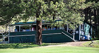
The main house at the historic James Cant Ranch
After Cant and his wife moved to the ranch, it became a popular overnight stop for people traveling between Dayville and the Columbia River. Their hospitality was well known, and it was not uncommon for the Cants to serve dinner to twenty or more people including family, ranch hands, and traveling guest. To accommodate their growing family, an expanding livestock business and their many guests, the Cants undertook a major expansion of the ranch between 1915 and 1918, replacing most of the original building constructed by the Officer family. As part of this expansion, Cant built a large main house that became the centerpiece of the ranch complex.[5][7][9]
In the 1920s, Cant acquired more land to expand his successful sheep business. He also improved the landscape around the main house, adding a large lawn, fencing the yard, and planting numerous shrubs and trees. The most important change was made by the State of Oregon, when it began construction of Highway 19 from Arlington on the Columbia River to Dayville. The highway follows the John Day River, passing just west of the Cant Ranch complex. It was completed in the mid-1920s, effectively ending the Cant's isolation. However, the highway was not paved until the mid-1930s.[10]
The Cant family kept their sheep operation going through the Great Depression. It recovered some during World War II; however, the shortage of labor made raising sheep increasingly difficult. As a result, Cant transitioned from sheep to cattle production in 1946. Over the next three decades the Cant's cattle operation grew and prospered. By 1965, the Cant ranch covered 6,500 acres (26km2) plus an additional 4,500 acres (18km2) leased from the Bureau of Land Management. At that time the ranch was sending 500 to 600 cattle to market each year. James Cant died in 1972, and his wife died in 1973. The Cant family sold the ranch to the National Park Service in 1975 to be incorporated into the new John Day Fossil Beds National Monument.[8][10][11]
National Park Service
National Park Service headquarters at the Cant Ranch
When the John Day Fossil Beds National Monument was established in 1975, the initial development plan recommended purchasing the Cant Ranch complex for use as the monument's headquarters and visitor center. The National Park Service purchased 878 acres (3.55km2) from the Cant family in 1975. This included the main ranch complex and adjacent ranch property along the John Day River. The National Park Service used the main house as a visitor center, museum, and office until the Thomas Condon Visitor Center was built in 2003. The ranch complex is now used as an interpretive site, giving visitors the experience of an early 20th-century livestock operation. The main house and several of the other buildings are open to the public.[12][13]
Today, the Cant Ranch offers visitors the opportunity to experience eastern Oregon's ranching heritage. Because the ranch played an important role in the commercial and social development of the John Day River Valley, the Cant Ranch was listed on the National Register of Historic Places in 1984. This historic district covers approximately 200 acres (81ha) along both sides of the John Day River. There are eleven historic buildings on the property.[13][14][8][15]
Structures
During the 1930s, there were at least seventeen buildings in the Cant Ranch complex. Today, there are eleven ranch buildings in the Cant Ranch Historic District. They are the main ranch house, a bunkhouse, a watchman's cabin, the barn and adjoining sheep pens, a workshop, general purpose shed, chicken coop, feed storage shed, privy, and an Officer era log cabin. There is also a small cabin on the east bank of the river known as Christina’s Cabin; however, it is in very poor condition and is not open to the public. The Cant family built two hand-operated cable cars for crossing the river, but only one is still operational. The ranch property displays original irrigation ditches, fences, gates, and feed racks plus vintage equipment purchased from the Cant family in 1978.[14][8]
Log cabin built by Floyd Officer in the 1890s
The main house is the most prominent building at the ranch. It was built sometime between 1915 and 1918. It is based on architectural designs from The Radford American Homes catalog, published 1903 by the Radford Architectural Company of Chicago. Cant hired two carpenters, Andrew Cress and Clarence Bisbee, to oversee construction of the house. The builders combined design features from several Radford plans to create the Cant's ranch house.[13][8]
Sheep Rock looking south from the Cant Ranch
The front of the main house faces Highway 19 with the back porch overlooking the river. The house is a two and one-half-story, wood-frame structure with a hip roof. It has wide porches that run the full length of the east and west sides of the structure. The eastern, river-view porch extends around the house, continuing about half the building's length along the north and south sides. The first floor is built around a central hallway that runs from front to back (east to west). Located off the main hall are a living room, dining room, kitchen, parlor, bedroom, bathroom, and a storage room. An open stairway in the central hall leads to the second floor. There are six bedrooms and a bathroom on the second floor. The third floor is a single open room that the Cant family used as a school room and as a gathering place for large social event.[13][8]
The other ranch buildings are all simple wood-frame structures. The barn was built about 1920. It is a 1+1⁄2-story timber-frame structure. Its footprint is approximately 60 feet (18m) by 120 feet (37m). The barn has vertical board siding and a gable roof with wood-shingles. Inside there are twelve bays divided into a number of stalls, holding pens, and storage areas. Attached to the north end of the barn is a single-story structure with stalls for sheep shearing. This structure is approximately 20 feet (6.1m) by 60 feet (18m). There is a workshop and a small shed west of the barn. The National Park Service uses these building for their original purposes. The larger building is a maintenance shop and the small structure is used for general-purpose storage. East of the barn is a one-room wood-frame watchman's cabin, used by shepherds during the lambing season.[8]
Closer to the main house is a bunkhouse, chicken-coop, feed storage shed, and a privy. All are wood-frame structures with wood-shingle roofs. After the National Park Service purchased the Cant property, the bunkhouse was renovated and used to house exhibits. The chick-coop still houses live chickens and the shed is used to store feed and ranch equipment. The National Park Service also replaced the original roofs on all these buildings in the 1980s to help preserve the structures. There is also small log cabin behind the main house. It is the only remaining structure that dates back to the Officer homestead period. The Officer family used the log cabin for storage, as did the Cant family.[8]
Location
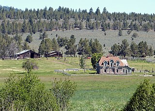
The Cant Ranch national historic district is located along the John Day River in northeastern Oregon. The elevation of the ranch is 2,244 feet (684m) above sea level. Sheep Rock is a prominent geographic feature located approximately 1 mile (1.6km) southeast of the ranch complex and can easily be seen from the ranch. There is a 0.5-mile (0.80km) hiking trail, known as the Sheep Rock Overlook Trail, that begins at the Cant Ranch and leads to an overlook with a view of the valley.[16]
The Cant Ranch is located within the boundaries of the Sheep Rock Unit of the John Day Fossil Beds National Monument. Highway 19 runs through the ranch property on the west side of the John Day River. The ranch complex is located on the east side of the roadway. The Thomas Condon Visitor Center is located across the highway from the ranch complex.[17]
The ranch is 8 miles (13km) northeast of Dayville, Oregon. From Dayville, travel west 2 miles (3.2km) on Highway 26 and then turn north on Highway 19. The ranch is 20 miles (32km) southeast of Spray, Oregon, on Highway 19. This route passed through the small unincorporated community of Kimberly, Oregon, 14 miles (23km) north of the ranch.[18][19]
Grant County is one of the 36 counties in the U.S. state of Oregon. As of the 2020 census, the population was 7,233, making it Oregon's fourth-least populous county. The county seat is Canyon City. It is named for President Ulysses S. Grant, who served as an army officer in the Oregon Territory, and at the time of the county's creation was a Union general in the American Civil War.
Dayville is a city along U.S. Route 26 in Grant County, in the U.S. state of Oregon. It was incorporated in 1913. The population was 149 at the 2010 census.
Dinosaur National Monument is an American national monument located on the southeast flank of the Uinta Mountains on the border between Colorado and Utah at the confluence of the Green and Yampa rivers. Although most of the monument area is in Moffat County, Colorado, the Dinosaur Quarry is located in Utah, north of the town of Jensen, Utah. The nearest Colorado town is Dinosaur while the nearest city is Vernal, Utah.
Agate Fossil Beds National Monument is a U.S. National Monument near Harrison, Nebraska. The main features of the monument are a valley of the Niobrara River and the fossils found on Carnegie Hill and University Hill.
The John Day River is a tributary of the Columbia River, approximately 284 miles (457 km) long, in northeastern Oregon in the United States. It is known as the Mah-Hah River by the Cayuse people, the original inhabitants of the region. Undammed along its entire length, the river is the fourth longest free-flowing river in the contiguous United States. There is extensive use of its waters for irrigation. Its course furnishes habitat for diverse species, including wild steelhead and Chinook salmon runs. However, the steelhead populations are under federal Endangered Species Act (ESA) protections, and the Chinook salmon have been proposed for such protection.
John Day Fossil Beds National Monument is a U.S. national monument in Wheeler and Grant counties in east-central Oregon. Located within the John Day River basin and managed by the National Park Service, the park is known for its well-preserved layers of fossil plants and mammals that lived in the region between the late Eocene, about 45 million years ago, and the late Miocene, about 5 million years ago. The monument consists of three geographically separate units: Sheep Rock, Painted Hills, and Clarno.
John Day was an American hunter and fur trapper in the Pacific Northwest, including present-day Oregon, Washington, Idaho, Western Montana and Southern British Columbia.
Thomas Condon (1822–1907) was an Irish Congregational minister, geologist, and paleontologist who gained recognition for his work in the U.S. state of Oregon.
Kimberly is an unincorporated community in Grant County, Oregon, United States. It is located at the intersection of Oregon Route 19 and Oregon Route 402 and the confluence of the John Day and the North Fork John Day rivers.
Oregon Caves Historic District covers 6 acres (24,000 m2) in the main visitor area of Oregon Caves National Monument in southern Oregon. The district includes four primary buildings plus two other structures. Because of the unique rustic architecture of these National Park Service buildings and the surrounding park landscape, the area was listed on the National Register of Historic Places in 1992.
Kinzua is a ghost town or former town site in Wheeler County, Oregon, United States. It existed as a company town from 1927 to 1978. Kinzua lies directly east of Fossil and uses a Fossil mailing address.
The Riddle Brothers Ranch is a pioneer ranch complex located in the Steens Mountain Cooperative Management and Protection Area in Harney County in eastern Oregon, United States. It is a rare extant example of the small family ranch. The ranch is located on both sides of the Little Blitzen River on public land and is administered by the Bureau of Land Management.
Merychyus is an extinct genus of oreodont of the family Merycoidodontidae, endemic to North America. It lived during the Miocene, 20.4—10.3 mya, existing for approximately 10 million years. Fossils are widespread through the central and western United States.
John Day Highway No. 5 is a highway in eastern Oregon. It comprises Oregon Route 19 (OR 19) and U.S. Route 26 (US 26), as well as short segments of OR 206, OR 207, and US 395.
John Miller Drake was a Union Army officer in the 1st Oregon Cavalry and the 1st Oregon Infantry regiments during the American Civil War. He eventually reached the rank of lieutenant colonel. He led one of the first campaigns to respond to the threat Chief Paulina posed to settlers and rival Indians in central Oregon. Later he was a purchasing agent for the Oregon Railway and Navigation Company.
The P Ranch is a historic ranch in Harney County in southeastern Oregon, United States. The remaining ranch structures are located on the west bank of the Donner und Blitzen River in the Malheur National Wildlife Refuge. The ranch was built by Peter French, a well known 19th-century cattle baron. The P Ranch became headquarters for the French-Glenn Livestock Company, which eventually covered over 140,000 acres (570 km2). After French was murdered in 1897, the French-Glenn Livestock Company slowly sold off the P Ranch property. In 1935, the United States Government purchased the remaining P Ranch property to add to an adjacent wildlife refuge. The Civilian Conservation Corps demolished most of the original ranch buildings in the 1930s, and a fire destroyed the main ranch house in 1947. The few remaining P Ranch structures are now listed on the National Register of Historic Places.
The Sod House Ranch is a historic ranch in Harney County in southeastern Oregon, United States. The remaining ranch structures are located south of Malheur Lake in the Malheur National Wildlife Refuge. The ranch was built by Peter French, a well known 19th-century cattle baron. The Sod House Ranch became the headquarters for the northern operating division of the French-Glenn Livestock Company, which eventually covered over 140,000 acres (570 km2). After French was murdered in 1897, the French-Glenn Livestock Company slowly sold off its ranch property. In 1935, the United States Government purchased the Sod House Ranch property to add to an adjacent wildlife refuge. The eight remaining Sod House Ranch buildings are now listed on the National Register of Historic Places.
Bakeoven is an unincorporated community in Wasco County, in the U.S. state of Oregon. It is southeast of Maupin and northwest of Shaniko along Bakeoven Creek, a tributary of the Deschutes River.
The Roba Ranch is a pioneer ranch located near the small unincorporated community of Paulina in Crook County, Oregon. The ranch is named for George and Mary Roba, sheep ranchers who acquired the property in 1892. Most of the important ranch buildings were constructed by the Roba family between about 1892 and 1910. Today, the ranch covers 1,480 acres (6.0 km2) and is privately owned. The ranch was listed on the National Register of Historic Places in 2007.
↑ Beckham, Stephen Dow and Florence K. Lentz, Indigenous Peoples and Cultures”, Rocks and Hard Places, Historic Resource Study, John Day Fossil Beds National Monument, National Park Service, United States Department of Interior, Seattle, Washington, 2000, p. 1.
1 2 3 Taylor, Terri and Cathy Gilbert, "Pre-Contact to Euro-American Settlement", Cultural Landscape Report; Cant Historical District], Cultural Resources Division, National Park Service, United States Department of Interior, Seattle, Washington, September 1996, pp. 19–20.
↑ "History of Forest Transportation System Development", Malheur national Forest Roads Analysis Report, Malheur National Forest, John Day, Oregon, United States Forest Service, United States Department of Agriculture, John Day, Oregon, December 2004, p. 14.
1 2 3 Beckham, Stephen Dow and Florence K. Lentz, "Early Settlement in the Vicinity of the National Monument”, Rocks and Hard Places, Historic Resource Study, John Day Fossil Beds National Monument, National Park Service, United States Department of Interior, Seattle, Washington, 2000.
↑ Taylor, Terri and Cathy Gilbert, "Officer Homestead Era: 1890–1909", Cultural Landscape Report; Cant Historical District, Cultural Resources Division, National Park Service, United States Department of Interior, Seattle, Washington, September 1996, pp. 21–24.
1 2 3 Taylor, Terri and Cathy Gilbert, "Cant Sheep Ranch: 1910–1946", Cultural Landscape Report; Cant Historical District], Cultural Resources Division, National Park Service, United States Department of Interior, Seattle, Washington, September 1996, pp. 27–29.
↑ "Life at the Cant Ranch", John Day Fossil Beds National Monument, National Park Service, United States Department of Interior, Kimberly, Oregon, August 15, 2006.
1 2 Taylor, Terri and Cathy Gilbert, "Cant Sheep Ranch: 1910–1946", Cultural Landscape Report; Cant Historical District, Cultural Resources Division, National Park Service, United States Department of Interior, Seattle, Washington, September 1996, pp. 30–40.
↑ Taylor, Terri and Cathy Gilbert, "Cant Cattle Ranch: 1946–1975", Cultural Landscape Report; Cant Historical District], Cultural Resources Division, National Park Service, United States Department of Interior, Seattle, Washington, September 1996, pp. 43–47.
↑ Taylor, Terri and Cathy Gilbert, "National Park Service: 1975–Present", Cultural Landscape Report; Cant Historical District, Cultural Resources Division, National Park Service, United States Department of Interior, Seattle, Washington, September 1996, pp. 51–52.
1 2 3 4 "Cant Ranch House Museum opens to the Public", John Day Fossil Beds, John Day Fossil Beds National Monument, National Park Service, United States Department of Interior, Kimberly, Oregon, Fall/Summer 2004.
1 2 Taylor, Terri and Cathy Gilbert, "Structures", Cultural Landscape Report; Cant Historical District, Cultural Resources Division, National Park Service, United States Department of Interior, Seattle, Washington, September 1996, pp. 69–77.
↑ "Sheep Rock Trails", John Day Fossil Beds National Monument, National Park Service, United States Department of Interior, Kimberly, Oregon, July 10, 2010.
↑ "Sheep Rock", John Day Fossil Beds National Monument, National Park Service, United States Department of Interior, Kimberly, Oregon, July 10, 2010.
↑ "Directions", John Day Fossil Beds National Monument, National Park Service, United States Department of Interior, Kimberly, Oregon, July 10, 2010.
↑ Cant Ranch topographic map, United States Geological Survey, United States Department of Interior, Reston, Virginia; displayed via ACME mapper, www.acme.com, July 10, 2010.
This page is based on this Wikipedia article Text is available under the CC BY-SA 4.0 license; additional terms may apply. Images, videos and audio are available under their respective licenses.