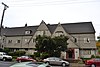
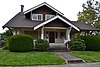
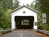
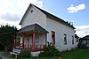
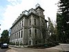
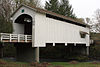
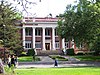
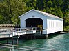
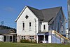
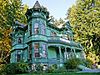
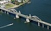
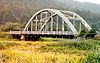
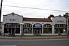
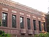
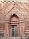
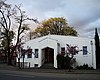
[5] Name on the Register Image Date listed [6] Location City or town Description 1 Alpha Phi Sorority House Alpha Phi Sorority House October 24, 1991 (# 91001564 1050 Hilyard St. 44°02′53″N 123°04′52″W / 44.048056°N 123.081111°W / 44.048056; -123.081111 (Alpha Phi Sorority House ) Eugene 2 Alpha Tau Omega Fraternity House (Old) Alpha Tau Omega Fraternity House (Old) September 1, 1983 (# 83002158 1143 Oak St. 44°02′50″N 123°05′23″W / 44.047222°N 123.089722°W / 44.047222; -123.089722 (Alpha Tau Omega Fraternity House (Old) ) Eugene 3 Archeological site 35LA1 Upload image September 10, 1997 (# 97001014 Address restricted [7] Searose Beach 4 Archeological site 35LA2 Upload image September 10, 1997 (# 97001016 Address restricted [7] Searose Beach 5 Archeological site 35LA4 Upload image September 10, 1997 (# 97001018 Address restricted [7] Searose Beach 6 Archeological site 35LA5 Upload image September 10, 1997 (# 97001019 Address restricted [7] Searose Beach 7 Archeological site 35LA6 Upload image September 10, 1997 (# 97001020 Address restricted [7] Searose Beach 8 Archeological site 35LA7 Upload image September 10, 1997 (# 97001021 Address restricted [7] Searose Beach 9 Archeological Site 35LA11 Upload image September 10, 1997 (# 97001025 Address restricted [7] Searose Beach 10 Archeological Site 35LA13 Upload image September 10, 1997 (# 97001026 Address restricted [7] Searose Beach 11 Archeological Site 35LA16 Upload image September 10, 1997 (# 97001027 Address restricted [7] Searose Beach 12 Archeological Site 35LA227 Upload image September 10, 1997 (# 97001024 Address restricted [7] Searose Beach 13 Archeological site 35LA228 Upload image September 10, 1997 (# 97001015 Address restricted [7] Searose Beach 14 Ax Billy Department Store Ax Billy Department Store August 26, 1982 (# 82003731 E. 10th Ave. and Willamette St. 44°02′56″N 123°05′28″W / 44.048889°N 123.091111°W / 44.048889; -123.091111 (Ax Billy Department Store ) Eugene Occupied by the Downtown Athletic Club, Conference Center, and the Ax Billy Grill & Sports Bar [8] 15 Baldwin Market Baldwin Market May 29, 1996 (# 96000619 765–781 Monroe St. 44°03′05″N 123°06′17″W / 44.051358°N 123.104732°W / 44.051358; -123.104732 (Baldwin Market ) Eugene 16 Abraham and Phoebe Ball House Abraham and Phoebe Ball House November 21, 2003 (# 03001181 1312 Lincoln St. 44°02′44″N 123°05′46″W / 44.045556°N 123.096111°W / 44.045556; -123.096111 (Abraham and Phoebe Ball House ) Eugene 17 Belknap Bridge Belknap Bridge November 29, 1979 (# 79002097 Off SR 126 44°10′06″N 122°13′37″W / 44.168333°N 122.226944°W / 44.168333; -122.226944 (Belknap Bridge ) Rainbow 18 Edwin E. Benedict House Edwin E. Benedict House October 18, 1979 (# 79002090 East of Florence on Cox Island 43°58′31″N 124°04′01″W / 43.975279°N 124.067069°W / 43.975279; -124.067069 (Edwin E. Benedict House ) Florence 19 Beta Theta Pi Fraternity House, Old Beta Theta Pi Fraternity House, Old October 30, 1989 (# 89001858 379–381 E. 12th Ave. 44°02′49″N 123°05′08″W / 44.046944°N 123.085556°W / 44.046944; -123.085556 (Beta Theta Pi Fraternity House, Old ) Eugene 20 Big Creek Bridge No. 01180 Big Creek Bridge No. 01180 August 5, 2005 (# 05000819 OR Coast 9, US 101, MP175.02 44°10′28″N 124°06′51″W / 44.174444°N 124.114167°W / 44.174444; -124.114167 (Big Creek Bridge No. 01180 ) Heceta Head 21 The Big "O" The Big "O" September 23, 2010 (# 10000800 Skinner Butte 44°03′28″N 123°05′34″W / 44.057778°N 123.092778°W / 44.057778; -123.092778 (The Big "O" ) Eugene 22 Bob Creek Site 35LA10 Upload image September 10, 1997 (# 97001023 Address restricted [7] Searose Beach 23 Clarence and Ethel Boyer House Clarence and Ethel Boyer House February 25, 2009 (# 09000061 1138 E. 22nd Ave. 44°02′07″N 123°04′32″W / 44.035278°N 123.075556°W / 44.035278; -123.075556 (Clarence and Ethel Boyer House ) Eugene 24 Windsor W. Calkins House Windsor W. Calkins House December 9, 1981 (# 81000498 588 E. 11th Ave. 44°02′51″N 123°04′58″W / 44.0475°N 123.082778°W / 44.0475; -123.082778 (Windsor W. Calkins House ) Eugene 25 Robert E. Campbell House Robert E. Campbell House November 1, 1979 (# 79002088 890 Aspen Dr. 44°03′14″N 123°02′31″W / 44.053889°N 123.041944°W / 44.053889; -123.041944 (Robert E. Campbell House ) Springfield 26 Cape Creek Bridge No. 01113 Cape Creek Bridge No. 01113 August 5, 2005 (# 05000820 OR Coast 9, US101, MP178.35 44°08′01″N 124°07′14″W / 44.133611°N 124.120556°W / 44.133611; -124.120556 (Cape Creek Bridge No. 01113 ) Heceta Head 27 Chambers Bridge Chambers Bridge November 29, 1979 (# 79002081 S. River Rd. 43°47′22″N 123°04′11″W / 43.78937°N 123.06968°W / 43.78937; -123.06968 (Chambers Bridge ) Cottage Grove 28 Frank L. and Ida H. Chambers House Frank L. and Ida H. Chambers House September 14, 1987 (# 87001537 1006 Taylor St. 44°02′56″N 123°06′47″W / 44.048889°N 123.113056°W / 44.048889; -123.113056 (Frank L. and Ida H. Chambers House ) Eugene 29 Fred E. Chambers House and Grounds Fred E. Chambers House and Grounds September 27, 1996 (# 96001047 1151 Irving Rd. 44°06′14″N 123°09′10″W / 44.103889°N 123.152778°W / 44.103889; -123.152778 (Fred E. Chambers House and Grounds ) Eugene 30 Chase Gardens Residential Grouping Chase Gardens Residential Grouping August 5, 1999 (# 99000943 274 S. Garden Way 44°03′32″N 123°03′06″W / 44.058889°N 123.051667°W / 44.058889; -123.051667 (Chase Gardens Residential Grouping ) Eugene 31 Chi Psi Fraternity House Chi Psi Fraternity House March 18, 1993 (# 91001563 1018 Hilyard St. 44°02′55″N 123°04′52″W / 44.048611°N 123.081111°W / 44.048611; -123.081111 (Chi Psi Fraternity House ) Eugene 32 Daniel and Catherine Christian House † Daniel and Catherine Christian House January 29, 2008 (# 07001507 170 E. 12th Ave. 44°02′47″N 123°05′20″W / 44.046389°N 123.088889°W / 44.046389; -123.088889 (Daniel and Catherine Christian House ) Eugene 33 Christian-Patterson Rental Property Christian-Patterson Rental Property October 24, 1991 (# 91001567 244 E. 16th Ave. 44°02′32″N 123°05′16″W / 44.042222°N 123.087778°W / 44.042222; -123.087778 (Christian-Patterson Rental Property ) Eugene 34 Jacob Clearwater House Jacob Clearwater House July 3, 2017 (# 100001273 1656 Clearwater Lane 44°01′35″N 122°57′04″W / 44.026348°N 122.951247°W / 44.026348; -122.951247 (Jacob Clearwater House ) Springfield 35 Coburg Historic District Coburg Historic District January 7, 1986 (# 86000036 Roughly bounded by Van Duyn Rd., Diamond and Miller Sts., Dixon St. and Tax lots 1700 and 201, and Bottom Loop Rd. 44°08′22″N 123°03′57″W / 44.139444°N 123.065833°W / 44.139444; -123.065833 (Coburg Historic District ) Coburg 36 Cochran-Rice Farm Complex Cochran-Rice Farm Complex October 17, 1991 (# 91001558 993 N. Lane St. 43°48′19″N 123°03′09″W / 43.805278°N 123.0525°W / 43.805278; -123.0525 (Cochran-Rice Farm Complex ) Cottage Grove Dismantled in 2012. [9] 37 Cottage Grove Armory Cottage Grove Armory March 7, 2012 (# 12000081 628 E. Washington Avenue 43°47′48″N 123°03′41″W / 43.796717°N 123.061341°W / 43.796717; -123.061341 (Cottage Grove Armory ) Cottage Grove 38 Cottage Grove Downtown Commercial Historic District Cottage Grove Downtown Commercial Historic District January 28, 1994 (# 93001568 Area surrounding Main St. between Coast Fork Willamette R. and Ninth St. 43°47′51″N 123°03′38″W / 43.7975°N 123.060556°W / 43.7975; -123.060556 (Cottage Grove Downtown Commercial Historic District ) Cottage Grove 39 Coyote Creek Bridge Coyote Creek Bridge November 29, 1979 (# 79002084 Southeast of Crow 43°58′12″N 123°19′08″W / 43.97°N 123.318889°W / 43.97; -123.318889 (Coyote Creek Bridge ) Crow 40 Creswell Public Library and Civic Improvement Club Clubhouse Creswell Public Library and Civic Improvement Club Clubhouse January 29, 2008 (# 07001508 195 S. 2nd St. 43°54′59″N 123°01′13″W / 43.916389°N 123.020278°W / 43.916389; -123.020278 (Creswell Public Library and Civic Improvement Club Clubhouse ) Creswell 41 Currin Bridge Currin Bridge November 29, 1979 (# 79002082 East of Cottage Grove 43°47′37″N 122°59′43″W / 43.793611°N 122.995278°W / 43.793611; -122.995278 (Currin Bridge ) Cottage Grove 42 Dads' Gates Dads' Gates August 11, 2004 (# 04000829 11th Ave. E. bet. Kincaid St. and Franklin Blvd. 44°02′52″N 123°04′35″W / 44.047778°N 123.076389°W / 44.047778; -123.076389 (Dads' Gates ) Eugene 43 Deadwood Creek Bridge Deadwood Creek Bridge November 29, 1979 (# 79002099 Northeast of Swisshome 44°08′37″N 123°43′13″W / 44.14361°N 123.720414°W / 44.14361; -123.720414 (Deadwood Creek Bridge ) Swisshome 44 Deady Hall Deady Hall April 11, 1972 (# 72001082 University of Oregon campus 44°02′48″N 123°04′31″W / 44.046667°N 123.075278°W / 44.046667; -123.075278 (Deady Hall ) Eugene Now known as University Hall 45 Devil's Elbow Site (35LA17) Upload image September 10, 1997 (# 97001028 Address restricted [7] Searose Beach 46 Dorena Bridge Dorena Bridge November 29, 1979 (# 79002086 Northwest of Dorena 43°44′14″N 122°53′01″W / 43.737222°N 122.883611°W / 43.737222; -122.883611 (Dorena Bridge ) Dorena 47 Dorris Apartments Dorris Apartments October 24, 1991 (# 91001565 963 Ferry Ln. 44°02′57″N 123°05′00″W / 44.049167°N 123.083333°W / 44.049167; -123.083333 (Dorris Apartments ) Eugene 48 Dorris Ranch Dorris Ranch June 22, 1988 (# 88000724 S. Second St. at Dorris Ave. 44°01′41″N 123°01′02″W / 44.028056°N 123.017222°W / 44.028056; -123.017222 (Dorris Ranch ) Springfield 49 Benjamin Franklin Dorris House Benjamin Franklin Dorris House February 23, 1996 (# 96000171 707 E. 17th Ave. 44°02′29″N 123°04′51″W / 44.041389°N 123.080833°W / 44.041389; -123.080833 (Benjamin Franklin Dorris House ) Eugene 50 East Skinner Butte Historic District East Skinner Butte Historic District September 23, 1982 (# 82003732 Pearl and High Sts., and 2nd and 3rd Aves. 44°03′25″N 123°05′17″W / 44.056944°N 123.088056°W / 44.056944; -123.088056 (East Skinner Butte Historic District ) Eugene 51 Ernest Bridge Ernest Bridge November 29, 1979 (# 79002094 Northeast of Marcola 44°12′04″N 122°50′10″W / 44.201111°N 122.836111°W / 44.201111; -122.836111 (Ernest Bridge ) Marcola 52 Eugene Blair Boulevard Commercial Historic District Eugene Blair Boulevard Commercial Historic District September 21, 1993 (# 93000928 Blair Blvd. between W. 3rd and W. 5th Aves., including Van Buren St. between Blair and W. 3rd 44°03′20″N 123°06′30″W / 44.055556°N 123.108333°W / 44.055556; -123.108333 (Eugene Blair Boulevard Commercial Historic District ) Eugene 53 Eugene Hotel Eugene Hotel October 7, 1982 (# 82001508 222 E. Broadway 44°02′59″N 123°05′21″W / 44.049711°N 123.089253°W / 44.049711; -123.089253 (Eugene Hotel ) Eugene Built in 1925; Americanized-Spanish architecture. [10] 54 Eugene Pioneer Cemetery Eugene Pioneer Cemetery August 1, 1997 (# 97000850 Jct. of E. Eighteenth Ave. and University St. 44°02′30″N 123°04′30″W / 44.041667°N 123.075°W / 44.041667; -123.075 (Eugene Pioneer Cemetery ) Eugene 55 First Congregational Church First Congregational Church February 12, 1980 (# 80003333 492 E. 13th Ave. 44°02′43″N 123°05′08″W / 44.04525°N 123.085472°W / 44.04525; -123.085472 (First Congregational Church ) Eugene 56 First Presbyterian Church First Presbyterian Church December 31, 1974 (# 74001690 216 S. 3rd St. 43°47′42″N 123°03′48″W / 43.795°N 123.063333°W / 43.795; -123.063333 (First Presbyterian Church ) Cottage Grove 57 Charles C. Fitch Farmstead Charles C. Fitch Farmstead June 16, 1989 (# 89000510 26689 Pickens Rd. 44°01′47″N 123°16′51″W / 44.029722°N 123.280833°W / 44.029722; -123.280833 (Charles C. Fitch Farmstead ) Eugene 58 Flanagan Site (35 LA 218) Upload image July 20, 1977 (# 77001106 Address restricted [7] Eugene 59 Foster–Simmons House Foster–Simmons House October 30, 2017 (# 100001773 417 E. 13th Ave. 44°02′45″N 123°05′11″W / 44.045710°N 123.086454°W / 44.045710; -123.086454 (Foster–Simmons House ) Eugene 60 Gamma Phi Beta Sorority House Gamma Phi Beta Sorority House October 24, 1991 (# 91001566 1021 Hilyard St. 44°02′55″N 123°04′50″W / 44.048611°N 123.080556°W / 44.048611; -123.080556 (Gamma Phi Beta Sorority House ) Eugene 61 Goodpasture Bridge Goodpasture Bridge November 29, 1979 (# 79002100 West of Vida 44°08′54″N 122°35′10″W / 44.148333°N 122.586111°W / 44.148333; -122.586111 (Goodpasture Bridge ) Vida 62 Howard A. Hall House Howard A. Hall House July 14, 1988 (# 88001036 1991 Garden Ave. 44°02′47″N 123°03′46″W / 44.046483°N 123.062664°W / 44.046483; -123.062664 (Howard A. Hall House ) Eugene 63 Elmer Harlow House Elmer Harlow House February 12, 1980 (# 80003334 2991 Harlow Rd. 44°04′12″N 123°03′49″W / 44.069880°N 123.063675°W / 44.069880; -123.063675 (Elmer Harlow House ) Eugene Built in 1922, this bungalow is a representative example of the style promoted by The Craftsman magazine. It is especially notable for fine detailing, including in woodwork and windows. The use of two-tone brickwork emphasizes the refined and careful construction. [11] 64 Hayse Blacksmith Shop Hayse Blacksmith Shop November 7, 1980 (# 80003335 357 Van Buren St. 44°03′21″N 123°06′29″W / 44.055833°N 123.108056°W / 44.055833; -123.108056 (Hayse Blacksmith Shop ) Eugene 65 Heceta Head Lighthouse and Keepers Quarters Heceta Head Lighthouse and Keepers Quarters November 28, 1978 (# 78002296 North of Florence on U.S. 101 44°08′15″N 124°07′37″W / 44.1375°N 124.126944°W / 44.1375; -124.126944 (Heceta Head Lighthouse and Keepers Quarters ) Florence 66 Jessie M. Honeyman Memorial State Park Historic District Jessie M. Honeyman Memorial State Park Historic District November 28, 1984 (# 84000473 U.S. 101 43°55′48″N 124°06′26″W / 43.930092°N 124.107206°W / 43.930092; -124.107206 (Jessie M. Honeyman Memorial State Park Historic District ) Dunes City 67 Johnson Hall Johnson Hall June 20, 1985 (# 85001351 E. 13th between University and Kincaid Sts. 44°02′43″N 123°04′29″W / 44.045278°N 123.074722°W / 44.045278; -123.074722 (Johnson Hall ) Eugene 68 William Kyle and Sons Building William Kyle and Sons Building December 2, 1981 (# 81000499 1297 Bay St. 43°58′00″N 124°06′19″W / 43.966667°N 124.105278°W / 43.966667; -124.105278 (William Kyle and Sons Building ) Florence 69 Lake Creek Bridge Lake Creek Bridge November 29, 1979 (# 79002091 West of Greenleaf 44°06′16″N 123°40′25″W / 44.104356°N 123.673678°W / 44.104356; -123.673678 (Lake Creek Bridge ) Greenleaf 70 Lane County Clerk's Building Lane County Clerk's Building November 25, 1983 (# 83004174 740 W. 13th Ave. 44°02′41″N 123°06′09″W / 44.044722°N 123.1025°W / 44.044722; -123.1025 (Lane County Clerk's Building ) Eugene 71 Lane County Farmers' Union Cooperative Wholesalers' Association Building Lane County Farmers' Union Cooperative Wholesalers' Association Building October 17, 1991 (# 91001560 532 Olive St. 44°03′14″N 123°05′37″W / 44.053889°N 123.093611°W / 44.053889; -123.093611 (Lane County Farmers' Union Cooperative Wholesalers' Association Building ) Eugene 72 Leaburg Hydroelectric Project Historic District Leaburg Hydroelectric Project Historic District June 29, 2015 (# 15000375 14348 McKenzie River Highway 44°06′05″N 122°41′20″W / 44.101433°N 122.688779°W / 44.101433; -122.688779 (Leaburg Hydroelectric Project Historic District ) Leaburg vicinity 73 Dr. Norman L. Lee House Dr. Norman L. Lee House November 2, 1977 (# 77001108 655 Holly St. 44°13′12″N 123°12′09″W / 44.22°N 123.2025°W / 44.22; -123.2025 (Dr. Norman L. Lee House ) Junction City 74 Log Cabin Inn Ensemble Log Cabin Inn Ensemble December 4, 2002 (# 02001486 56483 McKenzie Highway 44°10′27″N 122°09′33″W / 44.174167°N 122.159167°W / 44.174167; -122.159167 (Log Cabin Inn Ensemble ) McKenzie Bridge 75 Lowell Bridge Lowell Bridge November 29, 1979 (# 79002085 East of Dexter 43°54′33″N 122°46′42″W / 43.909167°N 122.778333°W / 43.909167; -122.778333 (Lowell Bridge ) Lowell 76 Lowell Grange Lowell Grange August 10, 2005 (# 05000849 51 E 2nd St. 43°55′17″N 122°46′54″W / 43.921389°N 122.781667°W / 43.921389; -122.781667 (Lowell Grange ) Lowell 77 Marx-Schaefers House † Marx-Schaefers House August 2, 2006 (# 06000662 1718 Lincoln St. 44°02′28″N 123°05′45″W / 44.041111°N 123.095833°W / 44.041111; -123.095833 (Marx-Schaefers House ) Eugene 78 Masonic Cemetery and Hope Abbey Mausoleum Masonic Cemetery and Hope Abbey Mausoleum September 15, 1980 (# 80003336 25th and University Sts. 44°01′53″N 123°04′24″W / 44.031389°N 123.073333°W / 44.031389; -123.073333 (Masonic Cemetery and Hope Abbey Mausoleum ) Eugene 79 Nelson and Margret Mathews House Nelson and Margret Mathews House June 14, 1984 (# 84003025 231 E. Pearl St. 44°08′13″N 123°03′50″W / 44.136944°N 123.063889°W / 44.136944; -123.063889 (Nelson and Margret Mathews House ) Coburg 80 McCracken Brothers Motor Freight Building McCracken Brothers Motor Freight Building September 21, 2005 (# 05001055 375 W. 4th St. 44°03′21″N 123°05′50″W / 44.055833°N 123.097222°W / 44.055833; -123.097222 (McCracken Brothers Motor Freight Building ) Eugene 81 McDonald Theater Building McDonald Theater Building August 26, 1982 (# 82003733 1004–1044 Willamette St. 44°02′55″N 123°05′30″W / 44.048611°N 123.091667°W / 44.048611; -123.091667 (McDonald Theater Building ) Eugene 82 Old McKenzie Fish Hatchery Old McKenzie Fish Hatchery February 23, 1996 (# 96000142 44645 McKenzie Hwy. 44°08′31″N 122°36′31″W / 44.141944°N 122.608611°W / 44.141944; -122.608611 (Old McKenzie Fish Hatchery ) Leaburg 83 McKenzie Highway Historic District McKenzie Highway Historic District February 7, 2011 (# 10001215 OR 242 44°14′55″N 121°50′18″W / 44.248611°N 121.838333°W / 44.248611; -121.838333 (McKenzie Highway Historic District ) Belknap Springs vicinity Extends into Linn and Deschutes counties. 84 McMorran and Washburne Department Store Building McMorran and Washburne Department Store Building March 2, 1989 (# 89000125 795 Willamette St. 44°03′05″N 123°05′29″W / 44.051389°N 123.091389°W / 44.051389; -123.091389 (McMorran and Washburne Department Store Building ) Eugene 85 Methodist Episcopal Church of Goshen Methodist Episcopal Church of Goshen October 17, 1991 (# 91001559 85896 First St. 43°59′45″N 123°00′37″W / 43.995833°N 123.010278°W / 43.995833; -123.010278 (Methodist Episcopal Church of Goshen ) Goshen 86 Wayne Morse Farm Wayne Morse Farm February 12, 1999 (# 99000066 595 Crest Dr. 44°01′23″N 123°05′55″W / 44.023056°N 123.098611°W / 44.023056; -123.098611 (Wayne Morse Farm ) Eugene 87 Mosby Creek Bridge Mosby Creek Bridge November 29, 1979 (# 79002083 East of Cottage Grove 43°46′41″N 123°00′13″W / 43.778056°N 123.003611°W / 43.778056; -123.003611 (Mosby Creek Bridge ) Cottage Grove 88 Musick Guard Station Musick Guard Station March 6, 1991 (# 91000170 Northeast of Bohemia Mtn., Umpqua NF 43°34′51″N 122°38′25″W / 43.580833°N 122.640278°W / 43.580833; -122.640278 (Musick Guard Station ) Cottage Grove 89 The Neptune Site (35LA3) Upload image September 10, 1997 (# 97001017 Address restricted [7] Searose Beach 90 Office Bridge Office Bridge November 29, 1979 (# 79003768 Crosses N. Fork Middle Fork Willamette River 43°46′04″N 122°29′40″W / 43.767778°N 122.494444°W / 43.767778; -122.494444 (Office Bridge ) Westfir 91 Oregon Electric Railway Passenger Station Oregon Electric Railway Passenger Station March 13, 1979 (# 79002087 27 E. 5th St. 44°03′17″N 123°05′28″W / 44.054722°N 123.091111°W / 44.054722; -123.091111 (Oregon Electric Railway Passenger Station ) Eugene 92 Oregon Power Company's Springfield Substation Oregon Power Company's Springfield Substation February 23, 1996 (# 96000170 590 Main St. 44°02′47″N 123°01′02″W / 44.046389°N 123.017222°W / 44.046389; -123.017222 (Oregon Power Company's Springfield Substation ) Springfield 93 Oregon Railway and Navigation Company Bridge Oregon Railway and Navigation Company Bridge March 13, 1980 (# 80003332 Southeast of Coburg 44°06′45″N 123°02′44″W / 44.1125°N 123.045556°W / 44.1125; -123.045556 (Oregon Railway and Navigation Company Bridge ) Coburg 94 Our Lady of Perpetual Help Roman Catholic Church Our Lady of Perpetual Help Roman Catholic Church February 21, 1997 (# 97000127 147 N. H St. 43°47′57″N 123°03′54″W / 43.799083°N 123.065°W / 43.799083; -123.065 (Our Lady of Perpetual Help Roman Catholic Church ) Cottage Grove 95 Pacific Cooperative Poultry Producers Egg-Taking Station Pacific Cooperative Poultry Producers Egg-Taking Station September 8, 1988 (# 88001523 506 Olive St. 44°03′12″N 123°05′37″W / 44.053333°N 123.093611°W / 44.053333; -123.093611 (Pacific Cooperative Poultry Producers Egg-Taking Station ) Eugene 96 Palace Hotel Palace Hotel December 23, 1977 (# 77001105 488 Willamette St. 44°03′16″N 123°05′35″W / 44.054537°N 123.093042°W / 44.054537; -123.093042 (Palace Hotel ) Eugene 97 Parvin Bridge Parvin Bridge November 29, 1979 (# 79003767 South of Dexter off Lost Creek Rd. 43°53′59″N 122°49′17″W / 43.899722°N 122.821389°W / 43.899722; -122.821389 (Parvin Bridge ) Dexter 98 Patterson-Stratton House Patterson-Stratton House September 29, 1992 (# 92001262 1605 Pearl St. 44°02′32″N 123°05′18″W / 44.042222°N 123.088333°W / 44.042222; -123.088333 (Patterson-Stratton House ) Eugene 99 Pengra Bridge Pengra Bridge November 29, 1979 (# 79002092 Spanning Fall Creek on Place Road [12] 43°57′58″N 122°50′43″W / 43.966056°N 122.845404°W / 43.966056; -122.845404 (Pengra Bridge ) Jasper vicinity 100 A. V. Peters House A. V. Peters House October 25, 1990 (# 90001597 1611 Lincoln St. 44°02′32″N 123°05′44″W / 44.042222°N 123.095556°W / 44.042222; -123.095556 (A. V. Peters House ) Eugene 101 Petersen Apartments † Petersen Apartments December 16, 2005 (# 05001420 1263 Oak St. 44°02′46″N 123°05′23″W / 44.046111°N 123.089722°W / 44.046111; -123.089722 (Petersen Apartments ) Eugene 102 Wallace and Glenn Potter House Wallace and Glenn Potter House April 24, 2007 (# 07000360 120 Fir Ln. 44°03′56″N 123°06′54″W / 44.065556°N 123.115°W / 44.065556; -123.115 (Wallace and Glenn Potter House ) Eugene 103 Psi Alpha Chapter, Chi Omega House Psi Alpha Chapter, Chi Omega House December 28, 2001 (# 01001402 1461 Alder St. 44°02′37″N 123°04′50″W / 44.043611°N 123.080556°W / 44.043611; -123.080556 (Psi Alpha Chapter, Chi Omega House ) Eugene 104 Quackenbush Hardware Store Quackenbush Hardware Store September 23, 1982 (# 82003734 160 E. Broadway 44°02′56″N 123°05′20″W / 44.048889°N 123.088889°W / 44.048889; -123.088889 (Quackenbush Hardware Store ) Eugene 105 Rice Apartments † Rice Apartments November 15, 2006 (# 06001031 360 W. 13th Ave. 44°02′43″N 123°05′52″W / 44.045322°N 123.097889°W / 44.045322; -123.097889 (Rice Apartments ) Eugene 106 Schaefers Building Schaefers Building October 30, 1979 (# 79003735 1001 Willamette St. 44°02′55″N 123°05′28″W / 44.048611°N 123.091111°W / 44.048611; -123.091111 (Schaefers Building ) Eugene 107 Shelton-McMurphey House and Grounds Shelton-McMurphey House and Grounds June 14, 1984 (# 84003028 303 Willamette St. 44°03′28″N 123°05′25″W / 44.057778°N 123.090278°W / 44.057778; -123.090278 (Shelton-McMurphey House and Grounds ) Eugene 108 Horace J. and Ann S. Shinn Cottage Horace J. and Ann S. Shinn Cottage March 5, 1998 (# 98000206 1308 Ash Ave. 43°47′56″N 123°04′10″W / 43.798889°N 123.069444°W / 43.798889; -123.069444 (Horace J. and Ann S. Shinn Cottage ) Cottage Grove 109 Siuslaw River Bridge No. 01821 Siuslaw River Bridge No. 01821 August 5, 2005 (# 05000816 OR Coast 9, US101, MP109.98 43°57′52″N 124°06′27″W / 43.964444°N 124.1075°W / 43.964444; -124.1075 (Siuslaw River Bridge No. 01821 ) Florence 110 Smeede Hotel Smeede Hotel January 17, 1974 (# 74001691 767 Willamette St. 44°03′06″N 123°05′28″W / 44.051667°N 123.091111°W / 44.051667; -123.091111 (Smeede Hotel ) Eugene 111 Southern Pacific Passenger Depot Southern Pacific Passenger Depot August 16, 2007 (# 07000823 433 Willamette St. 44°03′18″N 123°05′29″W / 44.055°N 123.091389°W / 44.055; -123.091389 (Southern Pacific Passenger Depot ) Eugene 112 Southern Pacific Railroad Passenger Station and Freight House Southern Pacific Railroad Passenger Station and Freight House February 24, 1993 (# 82005088 101 S. A St. 44°02′41″N 123°00′56″W / 44.044722°N 123.015556°W / 44.044722; -123.015556 (Southern Pacific Railroad Passenger Station and Freight House ) Springfield 113 Springfield General Hospital Springfield General Hospital September 1, 1983 (# 83002159 846 F St. 44°03′06″N 123°00′52″W / 44.051644°N 123.014369°W / 44.051644; -123.014369 (Springfield General Hospital ) Springfield 114 Springfield High School Upload image October 23, 2023 (# 100009475 525 Mill Street 44°03′01″N 123°01′32″W / 44.0502°N 123.0256°W / 44.0502; -123.0256 (Springfield High School ) Springfield 115 Springfield Motors Buick Dealership Springfield Motors Buick Dealership June 1, 2011 (# 11000328 702 North A St. 44°02′50″N 123°01′00″W / 44.047222°N 123.016667°W / 44.047222; -123.016667 (Springfield Motors Buick Dealership ) Springfield 116 Stewart Bridge Stewart Bridge November 29, 1979 (# 79002102 Southeast of Walden 43°45′59″N 122°59′35″W / 43.766389°N 122.993056°W / 43.766389; -122.993056 (Stewart Bridge ) Walden 117 LaSells D. Stewart House LaSells D. Stewart House January 28, 1994 (# 93001569 1807 E. Main St. 43°47′50″N 123°02′50″W / 43.797222°N 123.047222°W / 43.797222; -123.047222 (LaSells D. Stewart House ) Cottage Grove 118 Strawberry Hill Site (35LA8) Upload image September 10, 1997 (# 97001022 Address restricted [7] Searose Beach 119 John Sutherland House John Sutherland House February 2, 1995 (# 94001631 83246 Lorane Highway 43°55′06″N 123°14′23″W / 43.918226°N 123.239683°W / 43.918226; -123.239683 (John Sutherland House ) Eugene 120 Ten Mile Creek Bridge No. 01181 Ten Mile Creek Bridge No. 01181 August 5, 2005 (# 05000818 OR Coast 9, US101, MP171.44 44°13′27″N 124°06′35″W / 44.22410°N 124.10959°W / 44.22410; -124.10959 (Ten Mile Creek Bridge No. 01181 ) Yachats vicinity 121 Thompson-Roach Building Thompson-Roach Building November 15, 2006 (# 06001032 544–550 E. 13th Ave. 44°02′43″N 123°04′59″W / 44.045278°N 123.083056°W / 44.045278; -123.083056 (Thompson-Roach Building ) Eugene Included in Eugene West University Neighborhood MPS 122 Triangle Lake Round Barn Triangle Lake Round Barn July 3, 2017 (# 100001274 19941 Highway 36 44°11′20″N 123°33′47″W / 44.188853°N 123.563096°W / 44.188853; -123.563096 (Triangle Lake Round Barn ) Blachly vicinity 123 Unity Bridge Unity Bridge November 29, 1979 (# 79002093 North of Lowell 43°56′43″N 122°46′26″W / 43.945278°N 122.773889°W / 43.945278; -122.773889 (Unity Bridge ) Lowell 124 University of Oregon Library and Memorial Quadrangle University of Oregon Library and Memorial Quadrangle March 9, 1990 (# 90000370 Kincaid St. at E. Fifteenth Ave. 44°02′38″N 123°04′39″W / 44.043767°N 123.077623°W / 44.043767; -123.077623 (University of Oregon Library and Memorial Quadrangle ) Eugene Includes the Knight Library 125 University of Oregon Museum of Art University of Oregon Museum of Art June 5, 1986 (# 86001224 1430 Johnson Lane 44°02′39″N 123°04′37″W / 44.044289°N 123.077004°W / 44.044289; -123.077004 (University of Oregon Museum of Art ) Eugene Also known as the "Jordan Schnitzer Museum of Art" 126 U.S. Post Office U.S. Post Office August 14, 1985 (# 85001805 520 Willamette St. 44°03′14″N 123°05′35″W / 44.053984°N 123.093152°W / 44.053984; -123.093152 (U.S. Post Office ) Eugene 127 Villard Hall Villard Hall April 11, 1972 (# 72001083 University of Oregon 44°02′50″N 123°04′35″W / 44.047222°N 123.076389°W / 44.047222; -123.076389 (Villard Hall ) Eugene 128 Washburne Historic District Washburne Historic District February 10, 1987 (# 87000042 Roughly bounded by G, N. Tenth, A, and N. Second Sts. 44°03′01″N 123°01′00″W / 44.050278°N 123.016667°W / 44.050278; -123.016667 (Washburne Historic District ) Springfield 129 Wendling Bridge Wendling Bridge November 29, 1979 (# 79002095 Northeast of Marcola 44°11′29″N 122°47′56″W / 44.191389°N 122.798889°W / 44.191389; -122.798889 (Wendling Bridge ) Wendling 130 Wildcat Creek Bridge Wildcat Creek Bridge November 29, 1979 (# 79002089 West of Eugene 44°00′13″N 123°39′09″W / 44.003611°N 123.6525°W / 44.003611; -123.6525 (Wildcat Creek Bridge ) Walton 131 Wilder Apartments † Wilder Apartments August 23, 2006 (# 06000727 259 E. 13th Ave. 44°02′45″N 123°05′15″W / 44.045833°N 123.0875°W / 44.045833; -123.0875 (Wilder Apartments ) Eugene 132 Willakenzie Grange Hall Willakenzie Grange Hall January 22, 2009 (# 08001368 3055 Willakenzie Rd. 44°04′55″N 123°03′47″W / 44.081825°N 123.063074°W / 44.081825; -123.063074 (Willakenzie Grange Hall ) Eugene 133 C. S. Williams House C. S. Williams House July 14, 1988 (# 88001037 1973 Garden Ave. 44°02′48″N 123°03′42″W / 44.046667°N 123.061667°W / 44.046667; -123.061667 (C. S. Williams House ) Eugene 134 Lew Williams Chevrolet Dealership Lew Williams Chevrolet Dealership June 1, 2011 (# 11000329 2020 Franklin Blvd. 44°02′39″N 123°03′44″W / 44.044167°N 123.062222°W / 44.044167; -123.062222 (Lew Williams Chevrolet Dealership ) Eugene 135 Woodrow Wilson Junior High School Woodrow Wilson Junior High School October 25, 1990 (# 90001602 650 W. Twelfth Ave. 44°02′47″N 123°06′04″W / 44.046389°N 123.101111°W / 44.046389; -123.101111 (Woodrow Wilson Junior High School ) Eugene 136 Women's Memorial Quadrangle Ensemble Women's Memorial Quadrangle Ensemble October 2, 1992 (# 92001320 Bounded by University St., Johnson Ln. and Pioneer Cemetery on the University of Oregon campus 44°02′38″N 123°04′28″W / 44.043889°N 123.074444°W / 44.043889; -123.074444 (Women's Memorial Quadrangle Ensemble ) Eugene 137 Woodmen of the World Hall Woodmen of the World Hall June 3, 1996 (# 96000618 291 W. 8th Ave. 44°03′04″N 123°05′50″W / 44.051178°N 123.097108°W / 44.051178; -123.097108 (Woodmen of the World Hall ) Eugene 138 James W. Working Flats James W. Working Flats August 26, 1994 (# 94001024 614 Lawrence St. 44°03′12″N 123°05′52″W / 44.053333°N 123.097778°W / 44.053333; -123.097778 (James W. Working Flats ) Eugene