
The Willamette River is a major tributary of the Columbia River, accounting for 12 to 15 percent of the Columbia's flow. The Willamette's main stem is 187 miles (301 km) long, lying entirely in northwestern Oregon in the United States. Flowing northward between the Oregon Coast Range and the Cascade Range, the river and its tributaries form the Willamette Valley, a basin that contains two-thirds of Oregon's population, including the state capital, Salem, and the state's largest city, Portland, which surrounds the Willamette's mouth at the Columbia.

Lane County is one of the 36 counties in the U.S. state of Oregon. As of the 2020 census, the population was 382,971, making it the fourth-most populous county in Oregon. The county seat is Eugene, the state's second most populous city. It is named in honor of Joseph Lane, Oregon's first territorial governor.

The Geographic Names Information System (GNIS) is a database of name and location information about more than two million physical and cultural features throughout the United States and its territories; the associated states of the Marshall Islands, Federated States of Micronesia, and Palau; and Antarctica. It is a type of gazetteer. It was developed by the United States Geological Survey (USGS) in cooperation with the United States Board on Geographic Names (BGN) to promote the standardization of feature names.

State Route 91 (SR 91) is a major east–west state highway in the U.S. state of California that serves several regions of the Greater Los Angeles urban area. A freeway throughout its entire length, it officially runs from Vermont Avenue in Gardena, just west of the junction with the Harbor Freeway, east to Riverside at the junction with the Pomona and Moreno Valley freeways.

Oregon OR 126 (OR 126) is a 204.63-mile-long (329.32 km) state highway that connects coastal, western, and central parts of the U.S. state of Oregon. A short freeway section of OR 126 in Eugene and Springfield is concurrent with Interstate 105 (I-105).

State Route 526 (SR 526), also known as the Boeing Freeway, is a state highway in Snohomish County, Washington, United States. The east–west highway travels 4.52 miles (7.27 km) and connects SR 525 in Mukilteo to Interstate 5 (I-5) in southern Everett. The highway serves the Boeing Everett Factory and Paine Field; it also serves as a main route to the city of Mukilteo and the state-run ferry to Whidbey Island.

Route 200, known locally as Saddle Road, traverses the width of the Island of Hawaiʻi, from downtown Hilo to its junction with Hawaii Route 190 near Waimea. The road was once considered one of the most dangerous paved roads in the state, with many one-lane bridges and areas of marginally maintained pavement. Most of the road has now been repaved, and major parts have new re-alignments to modern standards. The highway is mostly one-lane in each direction, but there are two lanes on the uphill portions. The highway reaches a maximum elevation of 6,632 feet (2,021 m) and is subject to fog and low visibility. Many rental car companies used to prohibit use of their cars on Saddle Road, but now allow use of the road. The highway experiences heavy use as it provides the shortest driving route from Hilo to Kailua-Kona and access to the slopes of Mauna Loa and the Mauna Kea Observatories.

Stafford is an unincorporated community, classified as a hamlet, in Clackamas County, Oregon, United States. It is a census-designated place (CDP), with a population of 1,577 as of the 2010 census. The community covers approximately 15.7 km2 located in a rough triangle south of Lake Oswego, east of Tualatin, and west of West Linn. Students in the area attend the schools of the West Linn-Wilsonville School District.

Maryland Route 27 is a state highway in the U.S. state of Maryland. Known for most of its length as Ridge Road, the highway runs 39.17 miles (63.04 km) from MD 355 in Germantown north to MD 30 in Manchester. MD 27 follows a ridge that separates several watersheds in northern Montgomery County and Carroll County. The highway connects Germantown and Manchester with Damascus in far northern Montgomery County; Westminster, the county seat of Carroll County; and Mount Airy, which lies at the junction of Carroll, Frederick, Howard, and Montgomery counties and where MD 27 intersects Interstate 70 (I-70)/U.S. Route 40.
Cornelius Pass Road is an arterial road in the Portland metropolitan area of Oregon, United States. The north-south road serves as an arterial connection between Burlington and Hillsboro. It intersects with several main roads throughout its route.
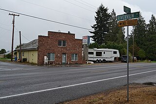
Riverview is an unincorporated locale in Lane County, Oregon, United States. Riverview lies at the intersection of River Road and Riverview Drive, southeast of Junction City, near the Willamette River.

Lorane is an unincorporated community in Lane County, Oregon, United States. It is located on Territorial Road about 20 miles (32 km) southwest of Eugene; it is 13 miles (21 km) northwest of Cottage Grove. The community is near the headwaters of the North Fork Siuslaw River in a valley in the foothills of the Central Oregon Coast Range. Local businesses include several wineries, including the King Estate Winery, Chateau Lorane Winery and Iris Hill Winery, and two general stores.

Amazon Creek is a stream that runs through southeastern and western Eugene, Oregon, United States. It is a tributary of the Long Tom River and is Eugene's second-largest waterway after the Willamette River.

In the U.S. state of Idaho, U.S. Route 95 (US-95) is a north–south highway near the western border of the state, stretching from Oregon to British Columbia for over 538 miles (866 km); it was earlier known in the state as the North and South Highway.

Maryland Route 178 is a state highway in the U.S. state of Maryland. Known as Generals Highway, the highway runs 8.06 miles (12.97 km) from MD 450 in Parole north to Veterans Highway near Millersville. MD 178 connects Annapolis with Crownsville in central Anne Arundel County. The highway is indirectly named for George Washington, who traveled the highway in 1783 on his way to Annapolis to resign his commission in the Continental Army at the conclusion of the American Revolutionary War. MD 178 was planned as early as 1910 as part of a western route between Baltimore and Annapolis. However, most of the highway south of MD 3 was not built until the early 1930s. The portion south of MD 3 served as a primary segment in the western corridor connecting Baltimore–Annapolis, until the construction of Interstate 97 (I-97) in the late 1980s.

Maryland Route 794 is a state highway in the U.S. state of Maryland. Known as Southern Maryland Boulevard, the highway runs 2.75 miles (4.43 km) from MD 4 in Bristol north to MD 408 at Waysons Corner in southwestern Anne Arundel County. MD 794 is the old alignment of MD 4 between Bristol and Waysons Corner. Southern Maryland Boulevard was constructed in the late 1920s and was designated MD 416. MD 416 was expanded to a divided highway in the early 1960s, shortly before MD 416 became part of MD 4. Northbound MD 4 followed the original alignment of MD 416 until MD 4 was upgraded to a freeway in the early 1990s and MD 794 was extended along its current course.
Linslaw is an unincorporated community in Lane County, Oregon, United States. It is located about eight miles west of Walton on Oregon Route 126 next to the Siuslaw River.
Tiernan is an unincorporated community in Lane County, Oregon, United States. It is about five miles west of Mapleton on Oregon Route 126 near the Siuslaw River and within the Siuslaw National Forest.

Coyote Creek is a tributary of the Long Tom River via Fern Ridge Reservoir in Lane County in the U.S. state of Oregon. Beginning in hills south of Eugene, it meanders generally north through Gillespie Corners and Crow before entering the reservoir east of Veneta.
Hadleyville is an unincorporated community in Lane County, Oregon, United States. It is located about two miles southeast of Crow along Territorial Highway, near Coyote Creek.


