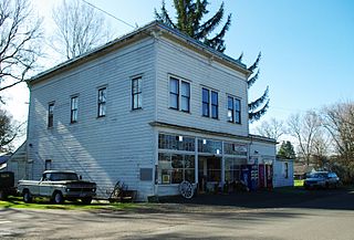
Orenco is a former company town in Washington County, Oregon, United States, located between Hillsboro and Aloha. The former community of Orenco now forms the Orenco neighborhood in Hillsboro, which is the site of the Orenco Station housing development.

Eagle Creek is an unincorporated community in Clackamas County, Oregon, United States. It is located seven miles southwest of Sandy, seven miles north of Estacada, and five miles southeast of Carver, at the junction of Oregon Routes 224 and 211, on the Clackamas River.
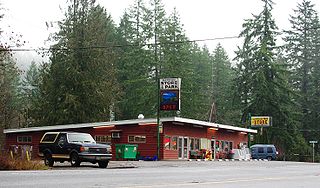
Rome, also called Rome Station after its sole business, is an unincorporated community in Malheur County, Oregon, United States. It is part of the Ontario, OR–ID Micropolitan Statistical Area. In the sparsely populated high desert of southeastern Oregon, Rome is immediately west of the Owyhee River on U.S. Route 95, approximately 12 miles (19 km) northeast of Burns Junction. Jordan Creek enters the river slightly downstream of Rome. The elevation of Rome is 3,390 feet (1,033 m) above sea level.
Reedville is an unincorporated community in Washington County, Oregon, United States, located between Hillsboro and Aloha. Oregon Route 8 runs through the area. The community is served by the Hillsboro School District, with some portions of the area within the city limits of Hillsboro.

Days Creek is an unincorporated community and census-designated place in Douglas County, Oregon, United States. At the 2010 census it had a population of 272.

Crane is a census-designated place and unincorporated community in Harney County, Oregon, United States, northeast of Malheur Lake on Oregon Route 78. Its population was 129 at the 2010 census.

Bull Run is an unincorporated community in Clackamas County, Oregon, United States. It is located about 5 miles (8.0 km) northeast of Sandy, near the Bull Run River and the powerhouse of the defunct Mount Hood Railway and Power Company.

Walton is an unincorporated community in Lane County, Oregon, United States. It is located halfway between Eugene and Florence on Oregon Route 126.

Gales Creek is an unincorporated community in Washington County, Oregon, United States on Oregon Route 8 northwest of Forest Grove in the foothills of the Oregon Coast Range.

Blachly is an unincorporated community in Lane County, Oregon, United States, on Oregon Route 36 in the Coast Range. Blachly lies along Lake Creek, about 3 miles (5 km) from Triangle Lake.

Diamond is an unincorporated community in Harney County, Oregon, United States. Diamond is west of Oregon Route 205 and south of Malheur Lake, 52 miles (84 km) south-southeast of Burns by highway. Its post office is assigned ZIP code 97722.

Greenleaf is an unincorporated community in Lane County, Oregon, United States. Greenleaf lies on Oregon Route 36 east of Deadwood and west of Triangle Lake.
Eddyville is an unincorporated community in Lincoln County, in the U.S. state of Oregon. Eddyville's unofficial estimated population as of 2014 was about 400 to 500.
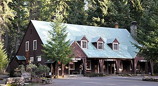
Union Creek is an unincorporated community in Jackson County in the U.S. state of Oregon. It is located along Union Creek and Oregon Route 62, about 15 miles (24 km) from Crater Lake National Park. The community is home to the Union Creek Historic District, which has been listed on the National Register of Historic Places since 1980.
Glenwood is an unincorporated community in Washington County, Oregon, United States, northwest of Forest Grove on Oregon Route 6.
Fair Oaks is an unincorporated community and census-designated place in Douglas County, in the U.S. state of Oregon. It lies at the south end of Driver Valley and along Calapooya Creek, between Sutherlin and Nonpareil by road and upstream from Oakland along the creek. As of the 2010 census, it had a population of 278.
Foots Creek is an unincorporated community and census-designated place (CDP) in Jackson County, in the U.S. state of Oregon. It lies along Oregon Route 99 near the mouth of Foots Creek, where it empties into the Rogue River. Interstate 5 and Valley of the Rogue State Park are on the side of the river opposite Foots Creek.
Alpha is an unincorporated community in Lane County, in the U.S. state of Oregon. Alpha is located at 44°09′51″N123°42′02″W.
Suntex is the name of an unincorporated community in Harney County, in the U.S. state of Oregon. It was established with the placement of a post office in the valley of Silver Creek west of Burns and north of U.S. Route 20.
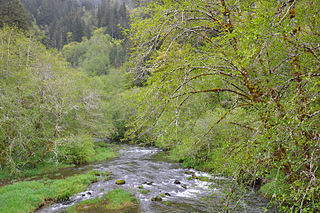
Deadwood Creek is a tributary of Lake Creek in the Siuslaw River basin in Lane County in the U.S. state of Oregon. Beginning near Taylor Butte in the Central Oregon Coast Range, it meanders generally southwest through the Siuslaw National Forest to meet the larger creek at the rural community of Deadwood. This is 5 miles (8 km) from Lake Creek's confluence with the river near Swisshome and 34 miles (55 km) by water from the Siuslaw River's mouth on the Pacific Ocean at Florence.


