
Eugene is a city in and the county seat of Lane County, Oregon, United States. It is located at the southern end of the Willamette Valley, near the confluence of the McKenzie and Willamette rivers, about 50 miles (80 km) east of the Oregon Coast.

Lane County is one of the 36 counties in the U.S. state of Oregon. As of the 2020 census, the population was 382,971, making it the fourth-most populous county in Oregon. The county seat is Eugene, the state's second most populous city. It is named in honor of Joseph Lane, Oregon's first territorial governor.

Oakridge is a city in Lane County, Oregon, United States. The population was 3,205 as of the 2010 census. It is located east of Westfir on Oregon Route 58, about 40 miles (64 km) east of Eugene and 150 miles (240 km) southeast of Portland. Surrounded by the Willamette National Forest and the Cascade Range, Oakridge is popular with outdoor enthusiasts for its hiking, mountain biking, wildflowers, fly fishing, birding, watersports, and the nearby Willamette Pass Resort.
Veneta is a city in Lane County, Oregon, United States. As of the 2010 census, the city population was 4,561.

The Long Tom River is a 57-mile (92 km) tributary of the Willamette River in western Oregon in the United States. It drains an area at the south end of the Willamette Valley between Eugene and Corvallis.

Mapleton is an unincorporated community in Lane County, Oregon, United States. It is located on Oregon Route 126 and the Siuslaw River, 45 miles (72 km) west of Eugene and 15 miles (24 km) east of Florence. It is also the western terminus of Oregon Route 36. As of the 2000 census, Mapleton had a total population of 918.

Noti is an unincorporated community in Lane County, Oregon, United States, located in the foothills of the Central Oregon Coast Range between Eugene and Florence. Per the 2000 census, Noti had a total population of 699.
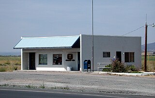
Riley is an unincorporated community in Harney County, Oregon, United States, located at the crossroads of U.S. Highway 395 and U.S. Highway 20, milepost 104, about 28 miles (45 km) west of Burns, the seat of Harney County. The elevation of Riley is 4,226 feet (1,288 m). The town presently consists entirely of two service establishments with attached apartments: a post office, and a general store with gas pump and garage service. It exists to serve the rural farming and ranching community that surrounds it, and highway travelers.
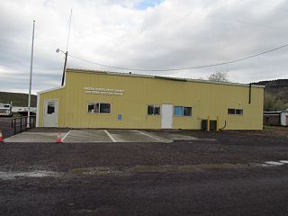
Drewsey is an unincorporated community in Harney County, in the U.S. state of Oregon. Drewsey is along the main stem of the Malheur River, about 45 miles (72 km) east of Burns, off U.S. Route 20. It has the ZIP Code of 97904.

Alvadore is an unincorporated community in Lane County, Oregon, United States, located nine miles northwest of downtown Eugene and one mile northeast of Fern Ridge Reservoir.

Laurelwood is an unincorporated community in Washington County, Oregon, United States. The community is located southwest of the Portland metropolitan area near Oregon Route 47 along Laurelwood Road, to the east of the city of Gaston and Wapato Lake. Laurelwood, a farming community, has a population of approximately 500 people. Settled in the 1860s, the community was home to Laurelwood Academy from 1904 until 2007. A large portion of the community is of the Seventh-day Adventist faith.

Elmira High School is a public high school in Elmira, Oregon, United States, located approximately 15 miles from Eugene, Oregon. It is one of the four schools of the Fern Ridge School District and provides an education of grades 9-12 for the city of Veneta, as well as for the towns of Elmira, Noti and Walton. Total enrollment numbers range from 350 to 450 students with a roughly even gender ratio. They operate on a seven period schedule over the course of two semesters, beginning in early September and ending in early June. EHS has four main buildings. In the lower left corner of the school consists of the main office and entrance, the theatre, library and the main studio for the school's radio station KOCF 92.7 FM, hosted by Stuart "Stu" Burgess. This building also contains the main hallways for the sophomore, junior and senior classes, as well as the counseling and learning centers. There is also an outdoor area outside of the building for social gatherings between students during passing periods and lunch. In the lower right corner is where the main gym and auxiliary gym are situated, as well as the freshman hallway and the Home Ec classroom. The auxiliary gym used to be the school's front entrance, however due to the athletics department asking for more practicing space and extracurricular opportunities, the auxiliary gym was built to satisfy those needs, and the school went for a more interior focused entrance. In the upper left corner is the Cafeteria, and in the upper right corner is the Band/Choir room, the weight room and workshops for students interested in welding, carpentry, woodworking and more.

Plush is an unincorporated rural community and census-designated place in the Warner Valley of Lake County, in the U.S. state of Oregon. As of the 2010 census it had a population of 57. The community is in an arid, sparsely populated part of the state 39 miles (63 km) by road northeast of Lakeview. The valley surrounding Plush contains many marshes and shallow lakes, most of them intermittent.
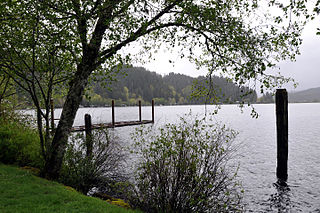
Triangle Lake is an unincorporated community in Lane County, Oregon, United States. It is about 25 miles (40 km) west of Junction City on Oregon Route 36, on the southwest side of the lake of same name. Lake Creek, a tributary of the Siuslaw River, enters and exits the lake. Triangle Lake is closely linked to the unincorporated community of Blachly, on the northeast side of the lake, and the two communities share the K-12 Triangle Lake School, the only school in Blachly School District. Triangle Lake is served by the Blachly post office and the Pioneer Telephone Cooperative.

Walterville is an unincorporated community in Lane County, Oregon, United States. It is located six miles (9.7 km) east of Springfield on Oregon Route 126 near the McKenzie River.

Irving was an unincorporated community in Lane County, Oregon, United States, and now partly within the Eugene city limits.

Diamond is an unincorporated community in Harney County, Oregon, United States. Diamond is west of Oregon Route 205 and south of Malheur Lake, 52 miles (84 km) south-southeast of Burns by highway. Its post office is assigned ZIP code 97722.

Bellfountain is a census-designated place and unincorporated community in Benton County, Oregon, United States. Bellfountain lies on Bellfountain Road north of Alpine and northwest of Monroe. The population was 75 at the 2010 census.

Amazon Creek is a stream that runs through southeastern and western Eugene, Oregon, United States. It is a tributary of the Long Tom River and is Eugene's second-largest waterway after the Willamette River.

Lookingglass is an unincorporated community and census-designated place in the Lookingglass Valley of Douglas County, Oregon, United States, about 9 miles (14 km) southwest of Roseburg. As of the 2010 census it had a population of 855. Lookingglass is considered a suburb of Roseburg.


