Veneta is a city in Lane County, Oregon, United States. As of the 2010 census, the city population was 4,561.

The Rogue River in southwestern Oregon in the United States flows about 215 miles (346 km) in a generally westward direction from the Cascade Range to the Pacific Ocean. Known for its salmon runs, whitewater rafting, and rugged scenery, it was one of the original eight rivers named in the Wild and Scenic Rivers Act of 1968. Beginning near Crater Lake, which occupies the caldera left by the explosive volcanic eruption and collapse of Mount Mazama, the river flows through the geologically young High Cascades and the older Western Cascades, another volcanic province. Further west, the river passes through multiple exotic terranes of the more ancient Klamath Mountains. In the Kalmiopsis Wilderness section of the Rogue basin are some of the world's best examples of rocks that form the Earth's mantle. Near the mouth of the river, the only dinosaur fragments ever discovered in Oregon were found in the Otter Point Formation, along the coast of Curry County.

The Hood River, formerly known as Dog River, is a tributary of the Columbia River in northwestern Oregon, United States. Approximately 25 miles (40 km) long from its mouth to its farthest headwaters on the East Fork, the river descends from wilderness areas in the Cascade Range on Mount Hood and flows through the agricultural Hood River Valley to join the Columbia River in the Columbia River Gorge.

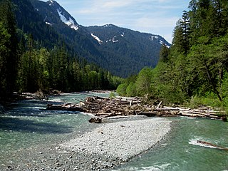
The McKenzie River is a 90-mile (145 km) tributary of the Willamette River in western Oregon in the United States. It drains part of the Cascade Range east of Eugene and flows westward into the southernmost end of the Willamette Valley. It is named for Donald McKenzie, a Scottish Canadian fur trader who explored parts of the Pacific Northwest for the Pacific Fur Company in the early 19th century. As of the 21st century, six large dams have been built on the McKenzie and its tributaries.

Lake Oroville is a reservoir formed by the Oroville Dam impounding the Feather River, located in Butte County, northern California. The lake is situated 5 miles (8 km) northeast of the city of Oroville, within the Lake Oroville State Recreation Area, in the western foothills of the Sierra Nevada. Known as the second-largest reservoir in California, Lake Oroville is treated as a keystone facility within the California State Water Project by storing water, providing flood control, recreation, freshwater releases to assist in controlling the salinity intrusion into the Sacramento-San Joaquin Delta and protecting fish and wildlife.

The Metolius River is a tributary of the Deschutes River in Central Oregon, United States, near the city of Sisters. The river flows north from springs near Black Butte, then turns sharply east, descending through a series of gorges before ending in the western end of the lake. The unincorporated community of Camp Sherman lies astride the southern end of the river. The name of the river comes from the Warm Springs or Sahaptin word mitula, meaning white salmon and referring to a light colored Chinook salmon and not a whitefish.
The Baker River is an approximately 30-mile (48 km), southward-flowing tributary of the Skagit River in northwestern Washington in the United States. It drains an area of the high North Cascades in the watershed of Puget Sound north of Seattle, and east of Mount Baker. With a watershed of approximately 270 square miles (700 km2) in a complex of deep valleys partially inside North Cascades National Park, it is the last major tributary of the Skagit before the larger river reaches its mouth on Skagit Bay. The river flows through Concrete, Washington, near its mouth and has two hydroelectric dams owned by Puget Sound Energy.

The Crooked River is a tributary, 125 miles (201 km) long, of the Deschutes River in the U.S. state of Oregon. The river begins at the confluence of the South Fork Crooked River and Beaver Creek. Of the two tributaries, the South Fork Crooked River is the larger and is sometimes considered part of the Crooked River proper. A variant name of the South Fork Crooked River is simply "Crooked River". The Deschutes River flows north into the Columbia River.

Lost Creek Lake is a reservoir located on the Rogue River in Jackson County, Oregon, United States. The lake is impounded by William L. Jess Dam which was constructed by the U.S. Army Corps of Engineers in 1977 for flood control and fisheries enhancement. The lake and dam were the first completed elements of the multi-purpose Rogue River Basin Project, consisting of Lost Creek Lake, Applegate Lake and the Elk Creek project. The lake is located approximately 27 miles (43 km) northeast of Medford.

Diamond Lake is a natural body of water in the southern part of the U.S. state of Oregon. It lies near the junction of Oregon Route 138 and Oregon Route 230 in the Umpqua National Forest in Douglas County. It is located between Mount Bailey to the west and Mount Thielsen to the east; it is just north of Crater Lake National Park.

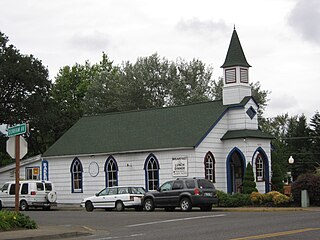
Walterville is an unincorporated community in Lane County, Oregon, United States. It is located six miles (9.7 km) east of Springfield on Oregon Route 126 near the McKenzie River.

The Chewaucan River is part of the Great Basin drainage. It flows 53 miles (85 km) through the Fremont–Winema National Forests, Bureau of Land Management land, and private property in southern Oregon. Its watershed consists of 651 square miles (1,690 km2) of conifer forest, marsh, and rural pasture land. The river provides a habitat for many species of wildlife, including native Great Basin redband trout, a subspecies of rainbow trout.

Marion Forks is an unincorporated community on the North Santiam Highway, 15 miles (24 km) south of the city of Detroit, in Linn County, Oregon, United States.

Blue River is a tributary of the McKenzie River in Linn and Lane counties in the U.S. state of Oregon. From its source at the confluence of Mann and Wolf creeks in the Cascade Range, it flows generally southwest to join the McKenzie near the community of Blue River. Saddle Dam and Blue River Dam block the river about 2 miles (3 km) from its mouth to form Blue River Reservoir, a multipurpose impoundment built in 1968 by the United States Army Corps of Engineers.

Cougar Dam is a 519-foot (158 m) tall rockfill hydroelectric dam in the U.S. state of Oregon. It has a gated concrete spillway and a powerhouse with two turbines totaling 25 megawatts of electric power.

The Old McKenzie Fish Hatchery was used to raise trout and salmon for release into the McKenzie River in western Oregon in the United States. It is located near the unincorporated community of Vida in Lane County. The hatchery is closed, however, the historic site is now a county park. It is also listed on the National Register of Historic Places.

Dexter Reservoir is a reservoir in Lane County, in the U.S. state of Oregon. It is about 16 miles (26 km) southeast of Eugene on the Middle Fork Willamette River, immediately downriver from Lookout Point Lake, another reservoir. The communities of Dexter and Lowell are near the lake. Oregon Route 58 follows the lake's southern shore, while Pengra Road parallels the lake's northern shore as far east as Lowell.
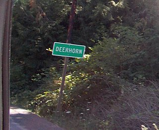
Deerhorn is an unincorporated community in Lane County, Oregon, United States. It is about 4 miles (6 km) west of Leaburg on Oregon Route 126 in the McKenzie River valley.

Blue River Reservoir is an artificial impoundment, about 6 miles (10 km) long, of the Blue River in Lane County in the U.S. state of Oregon. The reservoir is about 1 mile (1.6 km) north of Oregon Route 126 in the Willamette National Forest about 45 miles (72 km) east of Eugene.
Pine Hollow Reservoir is an impoundment of water from Threemile and Pine Hollow creeks on the east flank of the Cascade Range in Wasco County, Oregon, United States. The reservoir, created in the 1960s to provide water for Errol Davis mint fields, lies on private land about 12 miles (19 km) west-northwest of Maupin near the boundary of the Mount Hood National Forest. Public access and fishing are permitted along most of the 3.2-mile (5.1 km) shoreline of the reservoir.


