
Noti is an unincorporated community in Lane County, Oregon, United States, located in the foothills of the Central Oregon Coast Range between Eugene and Florence. Per the 2000 census, Noti had a total population of 699.

Goshen is an unincorporated community in Lane County, Oregon, United States. It is located at the junction of Oregon Route 58, Oregon Route 99, and Interstate 5.
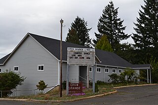
Crow is an unincorporated community in Lane County, Oregon, United States.

Vida is an unincorporated community in Lane County, Oregon, United States. It is located on Oregon Route 126 and the McKenzie River.
Winchester is an unincorporated community in Douglas County, Oregon, United States. It is on the south bank of the North Umpqua River 4 miles (6.4 km) north of Roseburg on Interstate 5 and is included in the Roseburg North CDP for statistical purposes.

Walton is an unincorporated community in Lane County, Oregon, United States. It is located halfway between Eugene and Florence on Oregon Route 126.

Gales Creek is an unincorporated community in Washington County, Oregon, United States on Oregon Route 8 northwest of Forest Grove in the foothills of the Oregon Coast Range.

Bethel is an unincorporated community in Polk County, Oregon, United States. It sits at the base of the Eola Hills in Plum Valley. Bethel is considered a ghost town as the only remaining structure is a school, now serving as a church. The locale was named by the Rev. Glen O. Burnett for a Church of Christ in Missouri where he had served as pastor. Bethel is a common name for churches as it is a Hebrew word that means "house of god". After traveling with his family on the Oregon Trail, Burnett settled on a Donation Land Claim in 1846. Burnett later rode circuit to the surrounding area, preaching in nearby communities, including Rickreall.

Farmington is an unincorporated community in Washington County, Oregon, United States. It is located on the Tualatin River, a tributary of the Willamette, about eight miles southwest of Beaverton, at the intersection of Oregon Route 10 and River Road. It is about two miles east of the junction of OR 10 with Oregon Route 219. Farmington was one of the earliest settlements in Oregon and was prominent for a time as an important milling and grain-shipping point on the Tualatin when steamships were the principal means of shipping grain along the Willamette River. Farmington was the site of an early Christian Church, founded by 1845 pioneers in Sarah and Philip Harris, who arrived in Oregon via the Meek Cutoff. At that time the locale was called "Bridgeport". Baptisms were in the Tualatin River.

Hardman is a historic community located in southern Morrow County, in the U.S. state of Oregon. It is on Oregon Route 207 about 20 miles (32 km) southwest of Heppner and 32 miles (51 km) north of Spray. Hardman is at an elevation of about 3,600 feet (1,100 m) in an agricultural area slightly west of the Blue Mountains of northeastern Oregon. Rock Creek, a tributary of the Columbia River, flows northwest by Hardman and to its south to meet the river at Lake Umatilla. A former social and commercial center for surrounding farm communities, Hardman became a ghost town following the completion of a railroad to Heppner in the 1920s. The main surviving commercial building, the Hardman IOOF Lodge Hall, was added to the National Register of Historic Places (NRHP) in 2012.
Goldson is an unincorporated community in Lane County, Oregon, United States on Oregon Route 36 near Bear Creek, about 3.5 miles (5.6 km) from Cheshire. Goldson post office was established in 1891 and named for the first postmaster, J. M. Goldson. It ran until 1934. The community's elevation is 404 feet (123 m).
Salt Creek is an unincorporated historic community in Polk County, Oregon, United States on Oregon Route 22 about six miles northwest of Dallas. As an early European American settlement of the Oregon Country, the cemetery at Salt Creek has graves dating back to 1847. Salt Creek, a tributary of the South Yamhill River, was named by early settlers for the salt licks found on its banks. The Salt Creek post office, named after the creek, was established in 1852 and closed in 1903. James B. Riggs, who arrived in Oregon via the Oregon Trail and the Meek Cutoff in 1845, was the first postmaster. Riggs previously been the first postmaster of Yoncalla, followed by Jesse Applegate.

Horton is an unincorporated community in Lane County, Oregon, United States. It is about three miles northeast of Blachly, in the Lake Creek valley of the Central Oregon Coast Range.
Walker is an unincorporated community in Lane County, Oregon, United States. It is located about 4 miles (6 km) north of Cottage Grove on Oregon Route 99, near the Coast Fork Willamette River.
Bridge is an unincorporated community in Coos County, Oregon, United States. It is about 9 miles (14 km) east of Myrtle Point on Oregon Route 42 near the Middle Fork Coquille River.
Cloverdale is an unincorporated community in Lane County, Oregon, United States. It is approximately 3 miles (5 km) northeast of Creswell on Oregon Route 222.
Clifton is an unincorporated community in Clatsop County, Oregon, United States. It is located north of U.S. Route 30, about nine miles northwest of Westport on the south bank of the Columbia River. It is on Clifton Channel across from Tenasillahe Island.
Black Butte was an unincorporated community in Lane County, Oregon, United States. It was located near Black Butte, a dark-colored mountain at the headwaters of the Coast Fork Willamette River, about 20 miles south of Cottage Grove, at the confluence of Garoutte Creek and the Little River. The Black Butte Mine, which operated from the 1890s to the 1960s, was one of the largest mercury mines in the state. Mercury contamination from abandoned mine tailings continues to be a health concern in the area, including mercury-contaminated runoff from Furnace Creek that has made its way to Cottage Grove Lake.
Canary is an unincorporated community in Lane County, Oregon, United States.

