Aurora, Nebraska

Last updated

Aurora, Nebraska
City
Hamilton County courthouse, Aurora, Nebraska, USA.jpg
Hamilton County courthouse in Aurora
Hamilton County Nebraska Incorporated and Unincorporated areas Aurora Highlighted.svg
Location of Aurora, Nebraska
Coordinates: 40°51′53″N98°00′27″W / 40.86472°N 98.00750°W / 40.86472; -98.00750
Country United States
State Nebraska
County Hamilton
IncorporatedJuly 3, 1877
Government
  TypeCouncil/Mayor
  MayorMarlin Seeman
Area
[1]
  Total3.31 sq mi (8.58 km2)
  Land3.28 sq mi (8.49 km2)
  Water0.03 sq mi (0.09 km2)
Elevation
[2]
1,795 ft (547 m)
Population
 (2020)
  Total4,678
  Density1,427.09/sq mi (550.93/km2)
Time zone UTC-6 (Central (CST))
  Summer (DST) UTC-5 (CDT)
ZIP code
68818
Area code 402
FIPS code 31-02690
GNIS feature ID2394036 [2]
Website http://www.cityofaurora.org/

Aurora is a city in Hamilton County, Nebraska, United States. The population was 4,479 at the 2010 census. It is the county seat of Hamilton County. [3]

Contents

History

In 1861, David Millspaw became the first permanent settler in the area of what was to become Aurora. Hamilton County was formed in 1870. [4]

Aurora was laid out as a town in 1871 by David Stone who named it after his former hometown of Aurora, Illinois. [5] [6] The county seat was transferred from Orville City (an extinct town) to Aurora in 1876. [5]

Geography

According to the United States Census Bureau, the city has a total area of 2.91 square miles (7.54 km2), of which 2.90 square miles (7.51 km2) is land and 0.01 square miles (0.03 km2) is water. [7] The average precipitation per year in Hamilton County during the years 1971 to 2000 was between 26 and 30 inches (660 and 760 mm). [8]

Demographics

Historical population
CensusPop.Note
1890 1,862
1900 1,9213.2%
1910 2,63036.9%
1920 2,96212.6%
1930 2,715−8.3%
1940 2,419−10.9%
1950 2,4551.5%
1960 2,5764.9%
1970 3,18023.4%
1980 3,71716.9%
1990 3,8102.5%
2000 4,22510.9%
2010 4,4796.0%
2020 4,6784.4%
U.S. Decennial Census [9]
2012 Estimate [10]

2010 census

At the 2010 census, [11] there were 4,479 people, 1,781 households and 1,199 families in the city. The population density was 1,544.5 inhabitants per square mile (596.3/km2). There were 1,939 housing units at an average density of 668.6 per square mile (258.1/km2). The racial makeup of the city was 97.7% White, 0.4% African American, 0.2% Native American, 0.2% Asian, 0.7% from other races, and 0.8% from two or more races. Hispanic or Latino of any race were 2.4% of the population.

There were 1,781 households, of which 33.7% had children under the age of 18 living with them, 55.7% were married couples living together, 8.5% had a female householder with no husband present, 3.1% had a male householder with no wife present, and 32.7% were non-families. 29.1% of all households were made up of individuals, and 15.3% had someone living alone who was 65 years of age or older. The average household size was 2.45 and the average family size was 3.00.

The median age in the city was 40.4 years. 26.5% of residents were under the age of 18; 5.7% were between the ages of 18 and 24; 23.3% were from 25 to 44; 25.7% were from 45 to 64; and 18.7% were 65 years of age or older. The gender makeup of the city was 48.4% male and 51.6% female.

2000 census

At the 2000 census, there were 4,225 people, 1,662 households and 1,163 families residing in the city. The population density was 2,243.0 inhabitants per square mile (866.0/km2). There were 1,798 housing units at an average density of 954.5 per square mile (368.5/km2). The racial makeup of the city was 97.92% White, 0.19% African American, 0.05% Native American, 0.43% Asian, 0.57% from other races, and 0.85% from two or more races. Hispanic or Latino of any race were 1.56% of the population.

There were 1,662 households, of which 34.9% had children under the age of 18 living with them, 59.3% were married couples living together, 7.8% had a female householder with no husband present, and 30.0% were non-families. 27.1% of all households were made up of individuals, and 14.1% had someone living alone who was 65 years of age or older. The average household size was 2.45 and the average family size was 2.98.

27.4% of the population were under the age of 18, 6.2% from 18 to 24, 25.7% from 25 to 44, 20.9% from 45 to 64, and 19.7% who were 65 years of age or older. The median age was 39 years. For every 100 females, there were 90.8 males. For every 100 females age 18 and over, there were 84.6 males.

The median household income was $37,690 and the median family income was $43,884. Males had a median income of $29,162 compared with $20,484 for females. The per capita income for the city was $17,309. About 6.1% of families and 6.2% of the population were below the poverty line, including 7.4% of those under age 18 and 5.4% of those age 65 or over.

Education

Public schools

Aurora is served by Aurora Public Schools

Media

Radio

Newspaper

Notable people

Related Research Articles

<span class="mw-page-title-main">Hamilton County, Nebraska</span> County in Nebraska, United States

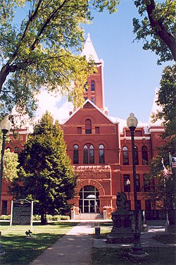
Hamilton County is a county in the U.S. state Nebraska. As of the 2020 United States Census, the population was 9,429. Its county seat is Aurora. The county was named for Alexander Hamilton, the first Secretary of the Treasury in the new United States government.

<span class="mw-page-title-main">Phillips County, Colorado</span> County in Colorado, United States

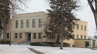
Phillips County is a county located in the U.S. state of Colorado. As of the 2020 census, the population was 4,530. The county seat is Holyoke. The county was named in honor of R.O. Phillips, a secretary of the Lincoln Land Company, who organized several towns in Colorado.

<span class="mw-page-title-main">Greendale, Indiana</span> City in Indiana, United States

Greendale is a city in Dearborn County, Indiana, United States. The population was 4,520 at the 2010 census.

<span class="mw-page-title-main">Aurora, Kansas</span> City in Cloud County, Kansas

Aurora is a city in Cloud County, Kansas, United States. As of the 2020 census, the population of the city was 56.

<span class="mw-page-title-main">Albion, Nebraska</span> City in Nebraska, United States

Albion is a city in and the county seat of Boone County, Nebraska, United States. The population was 1,650 at the 2010 census.

<span class="mw-page-title-main">Edgar, Nebraska</span> City in Nebraska, United States

Edgar is a city in Clay County, Nebraska, United States. The population was 498 at the 2010 census. It is part of the Hastings, Nebraska Micropolitan Statistical Area.

<span class="mw-page-title-main">Fairfield, Nebraska</span> City in Nebraska, United States

Fairfield is a city in Clay County, Nebraska, United States. The population was 387 at the 2010 census. It is part of the Hastings, Nebraska Micropolitan Statistical Area.

<span class="mw-page-title-main">Dakota City, Nebraska</span> City in Dakota County, Nebraska, United States

Dakota City is a city in Dakota County, Nebraska, United States. The population was 1,919 at the 2010 census. It is the county seat of Dakota County. Tyson Foods' largest beef production plant is located in Dakota City.

<span class="mw-page-title-main">Chappell, Nebraska</span> City in Nebraska, United States

Chappell is a city and county seat of Deuel County, Nebraska, United States. The population was 929 at the 2010 census.

<span class="mw-page-title-main">Benkelman, Nebraska</span> City in and county seat of Dundy County, Nebraska, United States

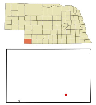
Benkelman is a city in and the county seat of Dundy County, Nebraska, United States. As of the 2020 census, the city population was 821.

<span class="mw-page-title-main">Burwell, Nebraska</span> City in Nebraska, United States

Burwell is a city in Garfield County, Nebraska, United States. The population was 1,210 at the 2010 census. It is the county seat of Garfield County.

<span class="mw-page-title-main">Wood River, Nebraska</span> Village in Hall County, Nebraska, United States

Wood River is a city in southwestern Hall County, Nebraska, United States. The population was 1,172 at the 2020 census. It is part of the Grand Island, Nebraska Metropolitan Statistical Area.

<span class="mw-page-title-main">Alma, Nebraska</span> City in Nebraska, United States

Alma is a city in Harlan County, Nebraska, United States. The population was 1,133 at the 2010 census. It is the county seat of Harlan County.

<span class="mw-page-title-main">Nelson, Nebraska</span> Village in Nebraska, United States

Nelson is a village and the county seat of Nuckolls County, Nebraska, United States. The population was 488 at the 2010 census. The city was named for C. Nelson Wheeler, the original owner of the town site.

<span class="mw-page-title-main">Grant, Nebraska</span> City in Nebraska, United States

Grant is a city and county seat of Perkins County, Nebraska, United States. The population was 1,165 at the 2010 census.

<span class="mw-page-title-main">Bassett, Nebraska</span> City in and county seat of Rock County, Nebraska, United States

Bassett is a city in Rock County, Nebraska, United States. The population was 538 at the 2020 census. It is the county seat of Rock County.

<span class="mw-page-title-main">Wilber, Nebraska</span> City in Saline County, Nebraska, United States

Wilber is a city in and the county seat of Saline County, Nebraska, United States. The population was 1,855 at the 2010 census. It is the county seat of Saline County. Wilber is the official "Czech Capital of the USA" and hosts an annual Czech festival in August. Wilber's school is the Wilber-Clatonia High School.

<span class="mw-page-title-main">Seward, Nebraska</span> City in and county seat of Seward County, Nebraska, United States

Seward is a city and county seat of Seward County, Nebraska, United States. The population was 6,964 at the 2010 census. Seward is part of the Lincoln, Nebraska Metropolitan Statistical Area.

<span class="mw-page-title-main">Deshler, Nebraska</span> City in Thayer County, Nebraska, United States

Deshler is a city in Thayer County, Nebraska, United States. The population was 739 at the 2020 census.

<span class="mw-page-title-main">Wayne, Nebraska</span> City in Wayne County, Nebraska, United States

Wayne is a city in Wayne County, Nebraska, United States. The population was 5,660 at the 2010 census. It is the county seat of Wayne County and the home of Wayne State College.

References

  1. "ArcGIS REST Services Directory". United States Census Bureau. Retrieved September 18, 2022.
  2. 1 2 U.S. Geological Survey Geographic Names Information System: Aurora, Nebraska
  3. "Find a County". National Association of Counties. Archived from the original on May 31, 2011. Retrieved 2011-06-07.
  4. Nebraska State Historical Society (June 4, 2004). "The Hamilton County Courthouse". Archived from the original on August 20, 2004. Retrieved September 11, 2009.{{cite web}}: CS1 maint: unfit URL (link)
  5. 1 2 "Aurora, Hamilton County". Center for Advanced Land Management Information Technologies. University of Nebraska. Retrieved August 10, 2014.
  6. Fitzpatrick, Lillian L. (1960). Nebraska Place-Names. University of Nebraska Press. p. 71. ISBN   0-8032-5060-6.
  7. "US Gazetteer files 2010". United States Census Bureau. Archived from the original on January 12, 2012. Retrieved 2012-06-24.
  8. PRISM Group and Oregon Climate Service, Oregon State University (2006). "Average Annual Precipitation, 1971–2000, Nebraska". Archived from the original on June 23, 2010. Retrieved July 16, 2010.
  9. United States Census Bureau. "Census of Population and Housing" . Retrieved October 18, 2013.
  10. "Annual Estimates of the Resident Population: April 1, 2010 to July 1, 2012". Archived from the original on October 19, 2013. Retrieved October 18, 2013.
  11. "U.S. Census website". United States Census Bureau . Retrieved June 24, 2012.
  12. "Aurora High School". Archived from the original on September 4, 2019. Retrieved September 4, 2019.
  13. "Clarence Mitchell Baseball Field Aurora, Nebraska" . Retrieved October 16, 2010.
  14. "Clarence Mitchell Stats". Baseball Almanac. Retrieved September 15, 2009.