Babar Islands

Last updated
Babar Islands
Native name:
Kepulauan Babar
Maluku Islands en.png
Babar Islands in the south of the Maluku Islands
Topographic map of Babar Islands-en.svg
Map of the Babar Islands.
Geography
Location Southeast Asia
Archipelago Maluku Islands
Administration
Province Maluku
Additional information
Time zone

The Babar Islands( Indonesian: Kepulauan Babar) are located in Maluku Province, Indonesia between latitudes 7 degrees 31 minutes South to 8 degrees 13 minutes South and from longitudes 129 degrees 30 minutes East to 130 degrees 05 minutes East. The group now constitutes five districts (kecamatan) within the Maluku Barat Daya Regency of Maluku province.

Contents

Tepa (a town with a population of about 2,000 people) is the administrative center of the Babar Islands district ("Kecamatan Pulau-Pulau Babar") now reduced to encompass only the western half of Babar Island together with Dai Island (to the north of Babar). Wetang Island (lying to the west of Babar) now forms a separate district. The town of Letwurung on the east side of Babar island is the capital of the district called "East Babar" ("Kecamatan Pulau-Pulau Babar Timor") in the east half of the Babar Islands, consisting of the East half of Babar Island. Masela Island (to the south-east of Babar) forms a separate district, as do the islands of Dawelor and Dawera (to the east). The archipelago covers a land area of 2,224 km2 and had 17,406 inhabitants at the 2010 Census. [1]

The Babar Islands are part of the Banda Sea Islands moist deciduous forests ecoregion.

Central island

The islands take their name from the large central island of Babar which is roughly 32 km (20 mi) across and a circumference of 97 km (60 mi). Babar Island has a maximum elevation of approximately 750 meters and is lightly covered with sub-tropical montane forest, although the 5 rivers and 2 large year-round springs afford tropical forest in their narrow ravine courses.

Topography

The topography of all the Babar islands is distinctive for their marked stepped appearance, the result of a combination of periodic uplifting of the tectonic plate interacting with the erosive action of the constant ocean waves. Water action on the coral base over the millennia has created many caves and shafts.

Agriculture and fisheries

Rain is plentiful from December to July so corn, plantains, bananas, cassava, various tubers and red rice (unirrigated) grow plentifully. Fish is the main source of protein. Sufficient potable water on Babar Island is provided by year round springs and shallow wells. Coconut oil is important for consumption while the oily meat called copra, is sold. Other items harvested and sold for export are sea shells, sea weed, sea cucumbers, shark fins, live lizards and birds, cattle, cashews, nutmeg, cloves and eucalyptus oil.

Smaller islands

This situation contrasts markedly with the much smaller islands ringing Babar Island. These are low-lying, uplifted reef and limestone (with the exception of Dai Island, which is largely granite), infertile, not heavily forested and lacking in fresh water sources. The more difficult environment leads the indigenous inhabitants to focus more of their energies on fishing and hand-crafts which are then traded for garden produce from Babar Island. The people collect rain water in large above ground cisterns which can last them through the driest time of the year (September to December). When the drought is longer than usual the water in these tanks is exhausted and the people have to walk miles to the few villages with springs or wells, and queue up for a turn to draw a few liters of water. People camp overnight beside the well waiting their turn. The Indonesian government has provided funds for many more collection tanks for rain water, so the situation has improved markedly in the last few years.

Transport

There is no airport or landing strip in the Babar Islands. Small freighters that have contracts to carry passengers service the islands. It is a minimum twelve-hour ride to the nearest city with an airport where one can catch a commercial flight to other towns in Maluku - these airports being at Tual, Larat, Wonreli (Kisar) and Ambon.

People

In comparison to the majority of Indonesians living nearer the political centre of the country, the indigenous Babar Islanders tend to have darker epidermal pigmentation, have kinky hair and generally lack the epicanthic eyefold of East Asians.

Religion

Most indigenous Babar Islanders are baptised into the Protestant Church of Maluku (Gereja Protestan Maluku, GPM). The GPM's roots are in the Dutch Reformed Church started by the Dutch colonists. Due undoubtedly to the aridity of the islands and the lack of natural resources, there has been no mass transmigration from more populous Indonesian areas. In Tepa, there are 3 other denominations with church buildings: a Catholic church, a Seventh-day Adventist church, and a Pentecostal church. There is also a mosque in Tepa that serves the small community of Muslims. All the other towns have one GPM church each, totaling 56 GPM churches in the entire GPM diocese of Babar islands ("Klasis GPM Pulau-pulau Babar"). While these world faiths are represented, there is much hybridization with the preexisting animist beliefs and practices. The traditional dance of Babar is "Seka".

See also

Islands in the Babar Islands cluster (in alphabetic order)

Related Research Articles

<span class="mw-page-title-main">Ambon Island</span> Island of Indonesia

Ambon Island is part of the Maluku Islands of Indonesia. The island has an area of 743.37 km2 (287.02 sq mi) and is mountainous, well watered, and fertile. Ambon Island consists of two territories: the city of Ambon to the south and various districts (kecamatan) of the Central Maluku Regency to the north. The main city and seaport is Ambon, which is also the capital of Maluku province, while those districts of Maluku Tengah Regency situated on Ambon Island had a 2020 Census population of 128,069. Ambon has an airport and is home to the Pattimura University and Open University, state universities, and a few private universities, which include Darussalam University and Universitas Kristen Indonesia Maluku (UKIM).

<span class="mw-page-title-main">Morotai Island Regency</span> Regency in North Maluku, Indonesia

Morotai Island Regency is a regency of North Maluku province, Indonesia, located on Morotai Island. It covers an area of 2,337.15 km2. The population was 52,860 at the 2010 census and 74,436 at the 2020 census.

<span class="mw-page-title-main">Kai Islands</span> Island group of Indonesia

The Kai Islands of Indonesia are a group of islands in the southeastern part of the Maluku Islands, located in the province of Maluku. The Moluccas have been known as the Spice Islands due to regionally specific plants such as nutmeg, mace, and cloves that originally intrigued the European nations of the 16th century.

<span class="mw-page-title-main">Tanimbar Islands</span> Group of islands in Maluku, Indonesia

The Tanimbar Islands, also called Timur Laut, are a group of about 65 islands in the Maluku province of Indonesia. The largest and most central of the islands is Yamdena; others include Selaru to the southwest of Yamdena, Larat and Fordata to the northeast, Maru and Molu to the north, and Seira, Wuliaru, Selu, Wotap and Makasar to the west. The Indonesian phrase timur laut means "east of the sea" or "northeast".

<span class="mw-page-title-main">Barat Daya Islands</span> Island group in Maluku, Indonesia

The Barat Daya Islands are a group of islands in the Maluku province of Indonesia. The Indonesian phrase barat daya means 'south-west'.

<span class="mw-page-title-main">Rote Island</span> Southernmost Island in Indonesia

Rote Island is an island of Indonesia, part of the East Nusa Tenggara province of the Lesser Sunda Islands. According to legend, this island got its name accidentally when a lost Portuguese sailor arrived and asked a farmer where he was. The surprised farmer, who could not speak Portuguese, introduced himself, "Rote".

<span class="mw-page-title-main">Buru</span> Island in Maluku, Indonesia

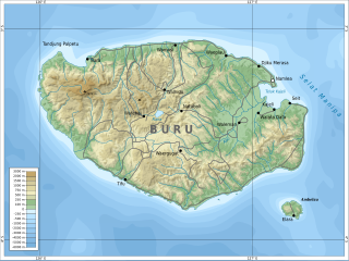
Buru is the third largest island within the Maluku Islands of Indonesia. It lies between the Banda Sea to the south and Seram Sea to the north, west of Ambon and Seram islands. The island belongs to Maluku province and includes the Buru and South Buru regencies. Their administrative centers, Namlea and Namrole, respectively, have ports and are the largest towns of the island, served by Namlea Airport and Namrole Airport.

<span class="mw-page-title-main">Maluku (province)</span> Province of Indonesia

Maluku is a province of Indonesia. It comprises the central and southern regions of the Maluku Islands. The main city and capital of Maluku province is Ambon on the small Ambon Island. The land area is 46,150.92 km2, and the total population of this province at the 2010 census was 1,533,506 people, rising to 1,848,923 at the 2020 census. The official estimate as at mid 2022 was 1,881,727. Maluku is located in Eastern Indonesia. It is directly adjacent to North Maluku, Southwest Papua, and West Papua in the north, Central Sulawesi, and Southeast Sulawesi in the west, Banda Sea, East Timor and East Nusa Tenggara in the south and Arafura Sea, Central Papua and South Papua in the east.

<span class="mw-page-title-main">Kisar</span> Island in Indonesia

Kisar, also known as Yotowawa, is a small island in the Southwestern Moluccas in Indonesia, located to the northeast of Timor Island. Most of the island is included within the Southernmost Islands District within the Southwest Islands Regency of Maluku Province. The District previously also includes the larger Romang Island further north, but this with its own outliers was subsequently split off to form its own district. The rest of the island forms the North Kisar District within the regency. It is one of the 92 officially listed outlying islands of Indonesia. The principal town is Wonreli, with 6,652 inhabitants at the 2010 Census.

<span class="mw-page-title-main">Run (island)</span> Village in Maluku Tengah, Maluku Province, Indonesia

Run is one of the smallest islands of the Banda Islands, which are a part of the Moluccas, Indonesia. It is located within Banda District (kecamatan) in Central Maluku Regency.

<span class="mw-page-title-main">Romang (island)</span> Island in Maluku, Indonesia

Romang is an island, part of Barat Daya Islands in Indonesia, located at 7.5833333°S 127.4333333°E, east of Wetar Island. Alternate names in use are Roma, Romonu and Fataluku. It is included within the Terselatan Islands District within the Barat Daya Islands Regency of the Maluku Province; the District also includes the smaller Kisar Island further south.

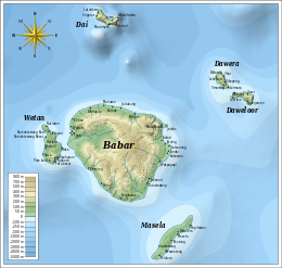
The Babar languages are a subgroup of the Austronesian language family spoken on the Babar Islands.

<span class="mw-page-title-main">Ambelau</span> Island and district in Buru Selatan Regency, Maluku Province, Indonesia

Ambelau or Ambalau is a volcanic island in the Banda Sea within Maluku Islands of Indonesia. The island forms an administrative district which is part of the South Buru Regency of Maluku province, Indonesia. It has a land area of 201.7 km2, and had a population of 6,846 at the 2010 Census. The administrative center is Wailua, a settlement located at the south of the island. About half of the island's population is composed of indigenous Ambelau people who speak the Ambelau language; the other half are mostly immigrants from the nearby Maluku Islands and Java.

<span class="mw-page-title-main">Southwest Maluku Regency</span> Regency in Maluku, Indonesia

Southwest Maluku Regency is a regency of Maluku Province, Indonesia. It comprises a number of islands and island groups in the south of the province, including Lirang Island, Wetar Island, Kisar Island, Romang Island, the Letti Islands, the Damer Islands, Mdona Hyera and the Babar Islands. The administrative centre lies at Tiakur on Moa Island, but the largest town is Wonreli.

<span class="mw-page-title-main">Kaimana Regency</span> Regency in West Papua, Indonesia

Kaimana Regency is a regency in the south of West Papua province of Indonesia. It covers an area of 18,500 sq. km, and had a population of 46,249 at the 2010 Census and 62,256 at the 2020 Census. The administrative centre is the town of Kaimana. The Mairasi languages are spoken in the regency, among other languages.

<span class="mw-page-title-main">Tual</span> City in Maluku, Indonesia

Tual is a city in Maluku Province of Indonesia located within the Kei Islands. In 2007, it was separated from the rest of the Kei Islands, which form the Southeast Maluku Regency to form an independent city.

The Protestant Church of Maluku is a Reformed church in Indonesia. It is known locally as: Gereja Protestan Maluku or simply GPM. It was formed on September 6, 1935 when it was separated from the Protestant Church in Indonesia. The Protestant Church of Maluku has congregations only in the provinces of Maluku and North Maluku.

<span class="mw-page-title-main">Thousand Islands (Indonesia)</span> Administrative regency in Jakarta, Indonesia

The Thousand Islands are a chain of islands to the north of Jakarta's coast. It forms the only regency of Jakarta, the capital of Indonesia. It consists of a string of 342 islands stretching 45 km (28 mi) north into the Java Sea at West Jakarta Bay and in fact north of Banten Province. Pramuka Island is the regency seat.

Wetan Island is an island, part of the Babar Islands, in the Moluccas, Indonesia. Its people speak the Wetan language. A species of moth was discovered on the island and named for it.

References

  1. Badan Pusat Statistik, Jakarta, 2018.

Coordinates: 7°55′S129°45′E / 7.917°S 129.750°E / -7.917; 129.750