Baijnath, Uttarakhand

Last updated

Baijnath
town
Baijnath Dham with Himalayas in the backdrop.jpg
BAIJNATH TEMPLE.jpg
Baijnath Lake, Uttarakhand.jpg
top to bottom: Baijnath Skyline, Baijnath Group of Temples and Baijnath Lake
India Uttarakhand location map.svg
Red pog.svg
Baijnath
Location in Uttarakhand, India
India location map.svg
Red pog.svg
Baijnath
Baijnath (India)
Coordinates: 29°55′N79°37′E / 29.92°N 79.62°E / 29.92; 79.62
CountryFlag of India.svg  India
State Uttarakhand
District Bageshwar
Established850 AD
Founded byNarsingh Deo
Languages
  Official Hindi
Time zone UTC+5:30 (IST)
Vehicle registration UK 02
Website uk.gov.in

Baijnath is a small town on the banks of the Gomati river in the Bageshwar district in Kumaon division of Uttarakhand, India. The place is most noted for its ancient temples, [1] which have been recognized as Monuments of National Importance by the Archaeological Survey of India in Uttarakhand. [2] Baijnath has been selected as one of the four places [3] to be connected by the 'Shiva Heritage Circuit' in Kumaon, under the Swadesh Darshan Scheme of the Government of India. [4] [5]

Contents

Baijnath, then known as Kartikeyapura, was the seat of the Katyuri kings who ruled over an area consisting of combined parts of Garhwal and Kumaun in modern-day state of Uttarakhand, India and Doti in Modern day Nepal.

History

Descriptive Board at the Temple Site by Archaeological Survey of India. The board depicts the temples to be made between 9th and 12th Century Ad by Katyuri Kings. Descriptive board, temples of Baijnath, Uttarakhand, India.jpg
Descriptive Board at the Temple Site by Archaeological Survey of India. The board depicts the temples to be made between 9th and 12th Century Ad by Katyuri Kings.

The first permanent settlement of the area was a town named Karvirpur or Karbirpur. [6] [7] The ruins of this town were used by Katyuri King Narsingh Deo to establish his capital in the area. [8] [9] Baijnath remained the capital of Katyuri Dynasty, who ruled the area from 7th-13th century AD., it was then known as Kartikeyapura. The katyuri kingdom then consisted of combined parts of Garhwal and Kumaun in modern-day state of Uttarakhand, India and Doti in Modern day Nepal.

After death of Birdeo the last king of united katyuri kingdom. the kingdom disintegrated in the 13th century giving rise to 8 different princely states. Baijnath remained under the rule of Baijnath Katyurs [10] [11] [12] descendants of Katyuri kings, till 1565 until king Balo Kalyan Chand of Almora annexed Baijnath to Kumaon. [13]

The Gorkhas of Nepal while expanding their kingdom westwards across Kali River, invaded and overran Almora, [14] the seat of the Kumaon Kingdom and other parts of Kumaon in 1791. In 1816, the Gorkhas were defeated by the East India Company [15] in Anglo-Nepalese War in 1814 [16] [17] [18] and were forced to cede Kumaon to the British as part of the Treaty of Sugauli. [19] :594 [20]

It was a small village with a population of 148 in 1901 although it has grown somewhat since. [21]

Geography

Baijnath Lake Baijnath Lake Uttarakhand India.jpg
Baijnath Lake

Baijnath is located at 29°55′N79°37′E / 29.92°N 79.62°E / 29.92; 79.62 , [22] 20 km northwest of Bageshwar city, in Bageshwar district in Uttarakhand. It has an average elevation of 1,130 metres (3,707 feet). Baijnath is situated in the Katyur valley of the Kumaon Himalayas at the left bank of Gomati river. Nearby villages include Dangoli, Gagrigol, Haat, Teet Bazar, Purara, Noghar, etc.

An artificial lake near the temple compound was announced in 2007-2008. [23] It was completed and inaugurated on 14 January 2016 by Harish Rawat, the then Chief Minister of Uttarakhand. [24] The lake is full of "Golden Mahaseer" fishes. Although fishing is strictly restricted at this site, the lake is a major tourist attraction where tourists offer chana to fishes. The nearby market is Garur which is supposed to be one of the oldest in the region.

Heritage

The temple is significant to Hindus because of mythology concerning its location near a river.

Baijnath Temple 2019.jpg
Temples of Baijnath Temples of Baijnath, Uttarakhand, India.jpg
Temples of Baijnath

There is a famous Baijnath Mandir (Lord Shiva) on the bank of the river which is said to have been built by the Kumaon Katyuri king in around 1150 A.D. and it was Capital of the Katyuri dynasty of kings who ruled Uttaranchal during 12th and 13th century, Baijnath was once known as Kartikyapura. One of the most important places to visit in Baijnath is the historically and religiously significant Baijnath Temple constructed in the twelfth century. The temple holds significance because, according to Hindu mythology, Lord Shiva and Parvati were married at the confluence of River Gomati and Garur Ganga. Dedicated to SivaVaidyanatha, the Lord of Physicians, the Baijnath temple is actually a temples’ complex built by the Katyuri kings with the idols of Shiva, Ganesh, Parvati, Chandika, Kuber, Surya and Brahma. Also the town of Baijnath draws its name from the temple. Situated on the left bank of the Gomti River at an elevation of 1,126 m, the temples are constructed in stone. The main temple that houses a beautiful idol of Parvati is chiseled in black stone. The temple is approached from the riverside by a flight of steps made of stones constructed by the orders of a Katyuri queen. On the way to the main temple, just below the house of the Mahanta, is the temple of Bamani. Legend goes that the temple was built by a Brahmin woman and dedicated to Lord Shiva. it is believed that it was built in one night by katyuri kings.

Around 2 km from Baijnath there is a temple of Bhagwati Mata Kot Bhramri Devi Temple or (Kot Ka Mandir) (traces of Ma Bhramri can be found in the last two paragraph of Chapter Eleven of Durga Shaptashati Path - The most sacred Hindu Book equivalent to Gita and Ramayana), which once was a fort owned by the Katyuri Kings. Also there is a myth that Adiguru Shankaracharya stayed on this temple overnight while en route to Badrinath. There is widespread belief among the local populace that the goddess, (after whom the temple is named) Kot Bhramri Devi's, Goddess face should not be shown to anyone except the priest of the temple if not followed this advice the entire Katur Valley will face ill luck and massive disaster will follow hence backside of the goddess is worshipped, except during the annual festival of "Nandaashtmi" during Bhadrapad Ashtami or Radha Ashtami during September month (the state government declares as State holiday) or when the Raj Jaat Yatra which takes place once in twelve year. Since last 150 Years buffalo and Lamb used to be sacrificed in the name of Nandaashtami has been stopped by The Honorable High Court of Nainital on a Public Interest Litigation filed by Animal Protection Society and as a result under police protection this practice has stopped. Though the Goddess Ma Bhramri is Satvik but some 200 years back during Nepalese Invasasion and their Kingdom, local deity Ma Nandadevi's status got installed at Kot Bhramri Mandir as a result animal sacrifice got started some 200 years back.

Commerce and tourism

For travelers, there are good lodging and boarding facilities at Baijnath with budget accommodation at the state run Tourist Reception Centre (TRC) and good rooms with all modern amenities can be availed at very cheap rates. Two kilometres further is a heli-pad facility for emergency landing for state and defence usage.

The chief occupation of its inhabitants are pensioners from retired services, State Government Teachers, Bankers, Post Officer Employees, Forest Services, agriculture, retired and serving defence personnel, petty and large shopkeepers dealing into day to day items and tea stall owners, butchers and finally point small scale taxi services.

There is a nearby market at Dangoli but main market remains two kilometers away at Garur which caters to household items, daily use goods to people and is considered to be biggest market place in the region after Almora, Ranikhet and Bageshwar District in Kumaon Hills up to Karanprayag District in Garhwal.

The market of Garur is one of the oldest in the region (since pre-independence days of the British Rule in India, but the market expanded during 1970 to 2010 with the efforts of local area people. Primarily, Garur is the last recognised and biggest Kumaon market prior to entering Garhwal via Kumaon en route to Garur Gwaldam road.

Transport

Pantnagar Airport, located in Pantnagar is the nearest Airport, while Kathgodam railway station is the nearest railway station to Baijnath. Baijnath is located at the junction of the Bageshwar-Gwaldam and the Almora-Gopeshwar road. It is connected to Haldwani, Bhimtal, Almora and Ranikhet by the 'Kumaun Darshan' service of Uttarakhand Transport Corporation. [25]

From Baijnath en route to Bageshwar Bridge which is motorable route up to 'Song' at sub town place called Kapkot whereby thousands of foreign as well as domestic trackers come to trek on Sunderdhunga as well as Pindari Glaciers which are within a trekable distance of one hundred km (fifty Up and fifty down trek on foot).

A discussion is being held on laying a railway track between Tanakpur to Bageshwar which if materialised would bring this district on faster national connectivity and invite much larger tourist population by 2020. [26] [27] [28]

Related Research Articles

<span class="mw-page-title-main">Kumaon division</span> Administrative division in India

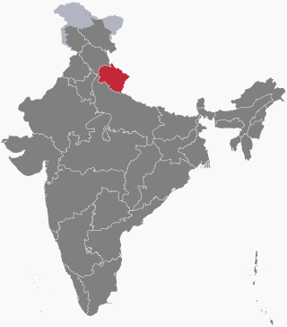
Kumaon is a revenue and administrative division in the Indian State of Uttarakhand. It spans over the eastern half of the state and is bounded on the north by Tibet, on the east by Nepal, on the south by the state of Uttar Pradesh, and on the west by Garhwal. Kumaon comprises six districts of the state: Almora, Bageshwar, Champawat, Nainital, Pithoragarh and Udham Singh Nagar.

<span class="mw-page-title-main">Almora district</span> District of Uttarakhand in India

Almora is a district in the Kumaon Division of Uttarakhand state, India. The headquarters is at Almora. It is 1,638 meters above sea level. The neighbouring regions are Pithoragarh district to the east, Chamoli district to the west, Bageshwar district to the north and Nainital district to the south.

<span class="mw-page-title-main">Gangolihat</span> Town in Uttarakhand, India

Gangolihat is a town in the Pithoragarh district of Uttarakhand, India. It is the headquarters of an eponymous tehsil ~ one of the 12 revenue subdivisions of the Pithorarh district.

<span class="mw-page-title-main">Chand kings</span> Medieval Indian Chand dynasty of Kumaon

The Chand dynasty was a Hindu dynasty that ruled the Kumaon area in present-day Uttarakhand state of India, after the decline of the Katyuri rule. At times, their rule also extended to the western parts of present-day Nepal. Somchand, who claimed Chandravanshi Rajput ancestry, established the dynasty, establishing his capital at Rajbunga in present-day Champawat.

<span class="mw-page-title-main">Pithoragarh</span> Town in Kumaon division, Uttarakhand, India

Pithoragarh is a Himalayan town with a Municipal Board in Pithoragarh district in the Indian state of Uttarakhand. It is the largest hill town in Kumaon Division.

<span class="mw-page-title-main">Bageshwar district</span> District of Uttarakhand in India

Bageshwar is a district of Uttarakhand state in northern India. The town of Bageshwar is the district headquarters. Prior to its establishment as a district in 1997 it was part of Almora district.

<span class="mw-page-title-main">Bageshwar</span> Town in Uttarakhand, India

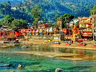
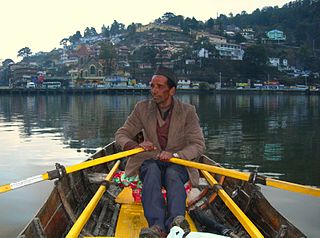
Bageshwar is a town and a municipal board in Bageshwar district in the state of Uttarakhand, India. It is located at a distance of 470 km from the National Capital New Delhi and 332 km from the State Capital Dehradun. Bageshwar is known for its scenic environment, glaciers, rivers and temples. It is also the administrative headquarters of Bageshwar district.

<span class="mw-page-title-main">Almora</span> Town in Uttarakhand, India

Almora is a municipal board and a cantonment town in the state of Uttarakhand, India. It is the administrative headquarters of Almora district. Almora is located on a ridge at the southern edge of the Kumaon Hills of the Himalaya range. The Koshi (Kaushiki) and Suyal (Salmale) rivers flow along the city and snow-capped Himalayas can be seen in the background.

<span class="mw-page-title-main">Lohaghat</span> City in Uttarakhand, India

Lohaghat is a town and a nagar palika in Champawat district in the Indian state of Uttarakhand. Lohaghat is also famous for its various cultural events like Holi Rang Mahotsav, Devidhar Mela ,etc. Most special thing regarding Lohaghat is the Ramleela of Lohaghat which is one of the oldest Ramleela of Kumaoun Division.

<span class="mw-page-title-main">Garur</span> Town in Uttarakhand

Garur is a town in the Bageshwar district of the state of Uttarakhand, India.

The Katyuri kings were a medieval Hindu ruling clan of Khasha origin that ruled over the regions in Uttarakhand in India and western Nepal from 700 to 1200 CE. The founder of this dynasty, King Vasu Dev was originally a Buddhist ruler, but later he started following Hindu practices sometimes attributed to a vigorous campaign of Hindu philosopher Adi Shankara.

<span class="mw-page-title-main">Kumaoni people</span> Ethnolinguistic group of India and Nepal

Kumaonis, also known as Kumaiye and Kumain, are an Indo-Aryan ethno-linguistic group who speak Kumaoni as their first-language and live mostly in Kumaon division in the state of Uttarakhand in India and parts of the Sudurpashchim Province in far western Nepal.

<span class="mw-page-title-main">Kumaon Kingdom</span> Independent Himalayan kingdom (600–1791)

Kumaon Kingdom was an independent Himalayan kingdom in Kumaon, a region located in the eastern part of the present-day Uttarakhand state of India. It was established around 7th century and remained an independent and sovereign kingdom until 1791.

<span class="mw-page-title-main">Kanda, Uttarakhand</span> Town in Uttarakhand, India

Kanda is a small historic town and tehsil in Bageshwar district, in the state of Uttarakhand, India.

<span class="mw-page-title-main">Bagnath Temple</span> Hindu Temple in Uttarakhand

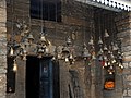
Bagnath Temple is an ancient shrine dedicated to Shiva, situated in the Bageshwar city at the confluence of Sarayu and Gomati rivers. Bagnath Temple is festooned with bells of all sizes and features impressive carvings. It is the most famous Temple in Bageshwar District. It is flooded with devotees on the occasion of Shivratri. The city of Bageshwar gets its name from this Temple.

<span class="mw-page-title-main">Gomati River (Uttarakhand)</span>

Gomati is a tributary of the Saryu River. The river originates in the higher reaches of Bhatkot northwest to the town of Baijnath in Uttarakhand, India. It joins Saryu at Bageshwar, which then proceeds towards Pancheshwar where it joins the Kali River.

<span class="mw-page-title-main">Outline of Uttarakhand</span> Overview of and topical guide to Uttarakhand

The following outline is provided as an overview of and topical guide to Uttarakhand:

<span class="mw-page-title-main">Sarju</span> River in Uttarakhand, India

The Sarju, also known as Sarayu, is a major river draining Central Kumaon region in the Indian state of Uttarakhand. Originating from Sarmul, Sarju flows through the cities of Kapkot, Bageshwar and Seraghat before joining Mahakali at Pancheshwar. The Sarju is the largest tributary of the Sharda River. The river forms the South-eastern border between the districts of Pithoragarh and Almora. Temperate and sub-Tropical forests cover the entire Catchment area of the River.

<span class="mw-page-title-main">Baijnath Temple Complex</span> Cluster of 18 Hindu temples, Baijnath, Uttarakhand, India

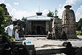
Baijnath Temple Complex is a cluster of 18 Hindu temples which are situated in the town of Baijnath in Uttarakhand, India. The complex is located in Bageshwar district along the banks of Gomati river at an elevation of 1,125 m (3,691 ft) above the mean sea level. These temples are renowned for possibly being one of the very few temples in the world where Parvati is depicted with her husband Shiva. Pilgrims arrive here on occasion of Shivratri and Makar Sankranti.

The Coolie-Begar or Coolie- Utar movement was a non-violent movement by the general public of Kumaun in the Bageshwar town of United Provinces in 1921. This movement was led by Hargovind Pant and Badri Datt Pandey, who were awarded the titles of 'Jannayak' and 'Kumaon Kesari' respectively after the success of this movement. The aim of this movement was to put pressure on the British to end the practice of Coolie-Begar. Mahatma Gandhi, while praising the movement, named it 'Bloodless Revolution'.

References

  1. Kohli, M. S. (2002). Mountains of India : tourism, adventure and pilgrimage. New Delhi: Indus Publ. Co. p. 148. ISBN   9788173871351.
  2. "List of Ancient Monuments and Archaeological Sites and Remains of Uttranchal - Archaeological Survey of India". asi.nic.in. Retrieved 18 November 2016.
  3. The other three include Jageshwar and Katarmal in Almora, and Devidhura in Champawat
  4. Kala, Gaurav (12 October 2016). "Lord shiva's temple in kumaun will be refurnished" (in Hindi). Dehradun: Dainik Jagran . Retrieved 6 May 2017.
  5. Negi, Sunil (4 March 2017). "Picture of Baijnath lake will change by 32 Crore". www.jagran.com (in Hindi). Bageshwar: Dainik Jagran . Retrieved 6 May 2017.
  6. Oakley, E. Sherman (1905). Holy Himalaya: The Religion, Traditions and Scenery of a Himalayan Province (Kumaon and Garhwál). Oliphant Anderson & Ferrier. p. 98.
  7. Handa, O. C. (2008). Panorama of Himalayan architecture. New Delhi: Indus. p. 217. ISBN   9788173872129.
  8. Misra, N.N. (1994). Source materials of Kumauni history. Almora, U.P. Hills: Shree Almora Book Depot. p. 166. ISBN   9788185865249.
  9. Epigraphia Indica. Manager of Publications. 1982. p. 114.
  10. Ramesh, S. (2001). Kumaon : jewel of the Himalayas. UBS Publishers' Distributors. OCLC   604020215.
  11. Kathoch, Y.S. A New History of Uttarakhand.
  12. Atkinson, Edwin Thomas (1981). The Himalayan gazetteer. Cosmo Publications. OCLC   832603490.
  13. "Home to ancient Katyuri culture" . Retrieved 4 August 2016.
  14. Hamilton, Francis; Buchanan, Francis Hamilton (1819). An Account of the Kingdom of Nepal: And of the Territories Annexed to this Dominion by the House of Gorkha. A. Constable. Retrieved 2 September 2016. The name Rajapur is also mentioned over a number of ancient copper plates.
  15. Lamb, Alastair (1986). British India and Tibet, 1766-1910 (2nd, rev. ed.). London: Routledge & Kegan Paul. ISBN   0710208723.
  16. Cross, John Pemble ; foreword by J.P. (2008). Britain's Gurkha War : the invasion of Nepal, 1814-16 ([Rev. ed.] ed.). London: Frontline. ISBN   978-1-84832-520-3.{{cite book}}: CS1 maint: multiple names: authors list (link)
  17. Naravane, M.S. (2006). Battles of the honourable East India Company : making of the Raj. New Delhi: A. P. H. Pub. Corp. ISBN   978-81-313-0034-3.
  18. Gould, Tony (2000). Imperial warriors : Britain and the Gurkhas. London: Granta Books. ISBN   1-86207-365-1.
  19. Martin, Robert Montgomery. The History of the Indian Empire. Mayur Publications.
  20. Summary of the operations in India: with their results : from 30 April 1814 to 31 Jan. 1823. Marquis of Hastings. 1824.
  21. Kartikeyapura The Imperial Gazetteer of India 1909, v. 6, p. 217.
  22. Falling Rain Genomics, Inc. - Baijnath
  23. "साकार हुआ बैजनाथ में झील निर्माण का सपना : दास" (in Hindi). Garur: Amar Ujala . Retrieved 6 May 2017.
  24. "सीएम करेंगे बैजनाथ झील का लोकार्पण" (in Hindi). Garur: Amar Ujala . Retrieved 6 May 2017.
  25. "सात को कुमाऊं दर्शन को रवाना होगा पहला दल" (in Hindi). Haldwani: Dainik Jagran . Retrieved 6 May 2017.
  26. Prashant, Shishir. "Demand for Tanakpur-Bageshwar railway line resurfaces". Dehradun: Business Standard. Retrieved 4 August 2016.
  27. Markuna, Rajendra S. "Tanakpur-Bageshwar rail project need of the hour". Haldwani: Daily Pioneer. Retrieved 4 August 2016.
  28. "ex mp tamta demands three railway lines". The Tribune. Pithoragarh . Retrieved 4 August 2016.